,_September_18,_1926_(5109773).jpg) | |
| Meteorological history | |
|---|---|
| Formed | September 11, 1926 |
| Dissipated | September 22, 1926 |
| Category 4 major hurricane | |
| 1-minute sustained (SSHWS/NWS) | |
| Highest winds | 150 mph (240 km/h) |
| Lowest pressure | 930 mbar (hPa); 27.46 inHg (estimated) |
| Overall effects | |
| Fatalities | 372–539+ |
| Damage | $100 million (1926 USD) (costliest U.S. hurricane on record when adjusted for wealth normalization) |
Areas affected | |
| [1][2] | |
Part of the 1926 Atlantic hurricane season | |
The 1926 Miami hurricane (also called the Great Miami Hurricane) was a large and intense tropical cyclone that devastated the Greater Miami area of Florida and caused catastrophic damage in the Bahamas and the U.S. Gulf Coast in September 1926, accruing a US$100 million damage toll. The devastation brought by the hurricane resulted in the end of Florida's land boom, and represented an early start to the Great Depression in the state. It has been estimated that a similar hurricane would cause about $235 billion in damage if it were to hit Miami in 2018.
The hurricane is believed to have formed in the central Atlantic Ocean on September 11.[a] Steadily strengthening as it tracked west-northwestward, the storm reached hurricane intensity the next day. As a result of scattered observations at open sea, however, no ship encountered the storm until September 15, by which time it had reached major hurricane intensity—Category 3 or higher on the Saffir–Simpson scale—north of the Virgin Islands. Strengthening continued up until the following day, when the storm reached peak intensity with a strength equivalent to a Category 4 hurricane. This intensity was maintained as the storm tracked across the Turks and Caicos and the Bahamas to landfall near Miami on September 18.
The hurricane caused immense destruction throughout the islands and across southern Florida. The storm destroyed hundreds of structures in its path over the islands, leaving thousands of residents homeless. At least 125 deaths occurred on the islands, though many others—some related only indirectly to the storm—were reported in the aftermath. Upon striking South Florida, the cyclone generated hurricane-force winds over a broad swath of the region, causing widespread and severe structural damage from both wind and water. Most of the deaths occurred near Lake Okeechobee, when a large storm surge breached muck dikes and drowned hundreds of people.
The hurricane quickly traversed the Florida peninsula before emerging into the Gulf of Mexico near Fort Myers. It flooded surrounding communities and barrier islands, while strong winds downed trees and disrupted electrical service. The storm later made two landfalls with weaker intensities on Alabama and Mississippi on September 20 and 21, respectively. It caused additional but less severe damage in those states, primarily from heavy rains and storm surge. Land interaction caused the cyclone to deteriorate and later dissipate on September 22.
Meteorological history
edit
Tropical storm (39–73 mph, 63–118 km/h)
Category 1 (74–95 mph, 119–153 km/h)
Category 2 (96–110 mph, 154–177 km/h)
Category 3 (111–129 mph, 178–208 km/h)
Category 4 (130–156 mph, 209–251 km/h)
Category 5 (≥157 mph, ≥252 km/h)
Unknown
The origins of the storm were from a tropical wave off West Africa in early September, likely near Portuguese Cape Verde, though weather stations in the island chain failed to detect it,[3] obscuring its precise formative area and date;[4] meteorologist Ivan Ray Tannehill placed it south of the Cape Verde islands on September 6.[5] Official records (HURDAT) overseen by the National Hurricane Center (NHC) initiate the cyclone as a strong tropical storm on September 11 in the tropical Atlantic, about midway between West Africa and the Lesser Antilles, as judged by the Atlantic hurricane reanalysis project in 2010.[6] From this point the storm—centered about 1,000 mi (1,610 km) east of the Caribbean—headed west-northwest at a steady clip of about 14 mph (23 km/h), a trajectory and pace it maintained for a week.[7] Toward the Bahamas and Florida it encountered few ships in its trek,[4] thwarting efforts by forecasters to track its whereabouts.[7]
At the same time it gradually strengthened, reaching hurricane threshold on September 12, and achieved sustained winds of 105 mph (165 km/h)—equal to Category 2 on the Saffir–Simpson scale—a few days later,[6] when reports wired to the United States Weather Bureau first verified its existence.[7] Unusually,[8] it coincided with three other storms in the Atlantic, including a pair of hurricanes—an event outdone only twice in history.[b][11][6] On September 15 the steamship Matura first reported hurricane-force winds northeast of Puerto Rico,[12] at which time the storm was already a major hurricane, Category 3 or higher on the Saffir–Simpson scale.[4] Overnight it bypassed the easternmost Greater Antilles,[13] and the next day intensified into the equivalent of a Category 4 hurricane, peaking with winds of 150 mph (240 km/h). Shortly afterward it hit the Lucayan Archipelago, passing north of Grand Turk Island and across the Bahamas at or near peak intensity on September 17,[14][6] though observations near its eye were scarce.[15]

On September 18 it crossed the Gulf Stream and at 12:00 UTC impacted Florida near Perrine, about 15 mi (30 km) south of downtown Miami, with winds of 145 mph (230 km/h).[16] Larger than usual, it was defined by its sprawling circulation, as shown by its radius of outermost closed isobar and broad hurricane-force wind swath;[17][8] its breadth greatly exceeded—perhaps triply—Hurricane Andrew, a storm of comparable potency, according to the Hurricane Research Division, which reviewed both storms. Winds of hurricane force swept the peninsula between St. Lucie County and the upper Florida Keys; conversely, similar winds in Hurricane Andrew only reached north to the Broward–Dade border.[18][19] A barometer at the Weather Bureau office in Miami measured a pressure of 27.61 inHg (935 mb),[20] a value then believed by meteorologists to be the lowest in the U.S. to date.[21][22] The eye of the storm entered Dade County between Homestead and northern Miami Beach,[20] causing a lull in the winds of up to 3⁄4 hour at any given point.[23] Wind and tidal data showed Miami was near the edge of the eye, implying a slightly lower reading—resolved to be 930 mb (27 inHg)—at its center,[24] 5 mb (0.15 inHg) lower than the value assigned before reanalysis.[25] Based on the duration of the calm, scientists in 2010 assessed a near-normal radius of maximum wind of 20 nmi (23 mi; 37 km),[4] while older analysis calculated an eye width of 13 mi (21 km).[23]
Moving inland at a brisk 19 mph (31 km/h), the cyclone slowly decelerated as it transited the Everglades,[7][26] passing well south of Lake Okeechobee. Weakening due to land interaction, it entered the Gulf of Mexico near Punta Rassa as a Category 2 hurricane. Once over water, it restrengthened and gradually took a more northwesterly course through the gulf, nearing the Florida panhandle on September 19. A day later, it attained a secondary peak of 125 mph (205 km/h) about 45 mi (70 km) south-southwest of Cape San Blas. Hours later it weakened and slowed dramatically offshore Pensacola, curving westward along the coastline. At 21:30 UTC it moved ashore near Perdido Beach, Alabama, as a low-end major hurricane with winds of 115 mph (185 km/h). After landfall, the storm quickly unraveled and meandered off Alabama's barrier islands, making a final landfall near Gulfport, Mississippi, as a moderate tropical storm. The cyclone continued its decay inland, degenerating into a tropical depression the following day before dissipating over Louisiana shortly thereafter.[6][16]
Storm progression
edit September 15: the hurricane passing north of the Leeward Islands
 September 16: the cyclone nears Grand Turk, with storms Four and Six to its west
 September 17: the storm over the Bahamas and approaching South Florida
 September 18: the storm over South Florida
 September 19: the storm over the eastern Gulf of Mexico
 September 20: the storm near Northwest Florida
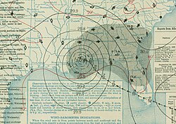 September 21: the storm over Alabama and Mississippi
.jpg)

.jpg)


.jpg)
Warnings and preparations
edit
On September 15 the Weather Bureau first apprised Florida of the storm, downplaying its immediate threat to the state,[27] though marine traffic linking Miami and the Bahamas was disrupted.[28]: 1, 4 On September 16, the agency advised caution to ships tracking in Bahamian waters and the Florida Straits,[29] at a time when the storm was predicted to miss Florida.[30]: 1 The first tropical cyclone warning associated with the storm was a northeast storm warning issued on September 17 for the Florida coast from Jupiter Inlet to Key West, Florida. Warnings along the United States Eastern Seaboard eventually stretched as far north as Charleston, South Carolina, upon the storm's first landfall. Additional warnings were posted for the United States Gulf Coast on September 19 and covered coastal areas from Apalachicola, Florida, to Burrwood, Louisiana. Information on the storm as ascertained by the Weather Bureau was relayed by various radio and local press services, though the bureau specifically acknowledged the Mobile Register for their efforts in disseminating storm details.[29]
.png)
A day before landfall various sources expected the storm to strike near Biscayne Bay, based on an extrapolation of its motion.[31] The issuance of warnings in the Miami area prompted boaters to relocate craft into sheltered locations;[32] similar precautions were taken in the Florida panhandle.[33]: 10 Miami officials guided overseers of building projects to fasten loose objects,[34] but few provisions were completed in time or made at all,[35] as hurricane warnings were not posted until near midnight. One historian noted that survivors recounted the storm a "frightening surprise",[36] worsened by deficient weather data over the Bahamas that delayed the release of warnings.[37] Local media refrained from the word "hurricane",[38] and the populace included many new arrivals with little hurricane awareness, many of whose names appeared on death lists after the storm.[39] Others belonged to at-risk groups such as uncounted migrants or racial minorities who resided in weak buildings, factors that likely magnified the death toll due to lowered readiness.[40][41]
Impact
editThe 1926 hurricane is known primarily for its impacts and lasting aftermath in South Florida,[42] particularly in the Miami area.[43] Effects were concentrated around Florida's southeastern coast and south-central Florida, with additional impacts in Northwest Florida.[4] The storm also heavily impacted the Lucayan Archipelago.[44]
Lucayan Archipelago
editThroughout the Lucayan Archipelago the storm affected the same areas as a similarly intense cyclone a few months prior, snarling ongoing rebuilding and depleting the meager income of many denizens, who ended up with higher debt levels—a cycle compounded by a third cyclone in October.[c][47] As it brushed the Turks and Caicos Islands the storm generated estimated winds of 150 mph (240 km/h), though its intensity at the time was based on the extent of damage there as any measurement device was knocked out by the damaging winds.[4] On Grand Turk the winds were strong enough to unroof buildings at the weather station and rip the spines off pricklypears.[48] The cyclone wrought extensive property damage there and on neighboring islands,[49] leaving 4,000 people homeless.[50] Most of the homes on Grand Turk were leveled, with the remainder damaged. Farming and salt harvesting, the islanders' means of livelihood, were devastated, raising fears of starvation and relief demands. A full recovery of the salt industry was determined to take months.[51][52]: 3 The majority of lighters at port were wrecked,[49] due to high surf that penetrated up to 3⁄4 mi (1.2 km) inland, depositing knee-deep sand drifts. Additionally, rainfall totals of up to 10 in (250 mm) attended the storm,[53] forming ruts in roads and wrecking waterside structures.[51] Despite tremendous losses, the storm produced few casualties, with no deaths reported across the Turks and Caicos Islands.[49]
Extreme damage extended into the Bahamas,[54] though due to lapsed communication, its extent was initially unclear.[55] The death toll in the archipelago reached 125, with several thousand injuries.[52]: 3 Wind gusts in the islands climaxed at 120 mph (190 km/h) in the capital Nassau, while Long Island clocked 102 mph (164 km/h). Bimini bore the brunt of the storm,[56][54] with the loss of over half the dwellings on North Bimini,[57] along with a wireless station, docks, and hotel. The sea overspread all but the crest of the island, marooning refugees who likened themselves to a "ship stranded atop a reef".[58] A school was badly damaged, canceling classes for months, as were several churches. Seawater lay 7 ft (2.1 m) deep in spots, contaminating potable supplies and resulting in 16 typhoid deaths, in addition to 25 fatalities from the direct effects of the storm. All ships in the harbor but one were sunk with their supplies.[59] On Andros the storm killed 30 people, of whom it drowned six, and severely damaged the north of the island, razing entire villages, large structures, and coconut groves. In Calabash Bay and Fresh Creek erosion exposed the public graves, causing the dead to be reburied in new plots.[56][60] On Exuma a large storm surge ruined many crops,[61] while strong winds downed trees and shattered homes on New Providence.[54] Over 52 lives were lost on Acklins and 25 more on Long Island. Inundations at the former spread as far as 3 mi (4.8 km) landward, killing many livestock and wildlife. Collectively the storm smashed 500 buildings there and on Crooked Island.[62] The yacht Advance was impaired off Castle Island and its crew of four saved.[63]
United States
editAccording to the American Red Cross, the storm caused 372 fatalities,[64][65] but these totals apparently do not include deaths outside the United States.[41] Prior to 2003, the National Weather Service (NWS) had long accepted 243 as the number of deaths,[1] but historical research indicated that this total was far too low.[66] The NWS then updated its totals to reflect the new findings.[67]
Florida
editAll known U.S. deaths occurred in Florida, along with 6,831 injuries.[41] The storm displaced approximately 38,000 people.[68][69] Agricultural losses totaled about $10 million, though crop-specific totals were inaccessible.[70]
Miami metropolitan area
edit
On Florida's Gold Coast—the tricounty area of Dade, Broward, and Palm Beach—the storm killed at least 220 people.[41] 114 deaths were reported from the city of Miami.[71] Although the official number of fatalities would later be revised downward,[1] initial estimates suggested that the death toll would likely be over 1,000 in Miami alone with an additional 2,000 injured.[69] News reports indicated that dozens of people were fatally pinned beneath fallen buildings.[72] The storm afflicted 13,825 residences in the Miami–Fort Lauderdale area, of which 4,725 were total losses.[71] The severest damage ran from Homestead to Deerfield,[73] with total destruction of buildings in some areas.[74] Damage figures from the storm in the Miami area alone reached $76 million,[71] accounting for most of the damage that the tropical cyclone wrought in South Florida.[73] Destructive winds lingered for 14 hours, due to the expansive wind field of the storm.[75]

The strongest winds buffeted Miami Beach, where records showed a one-minute peak of 130 mph (210 km/h);[76][4] at the time this was the top wind reading on record in the U.S., adjusted for elevation, bias, and timescale. Due to anemometer failure,[77] extrapolation suggested speeds may have neared 150 mph (240 km/h).[78] In Miami 10,000 homes lost their roofs or suffered other wind damage. The winds blew out hundreds of downtown shop windows, enticing looters.[79]: 1, 3 Due to their susceptibility to strong winds, most wooden buildings in Miami were either blown down or lost their roofs. Concrete and steel buildings were warped at their bases. Many of the injuries in the city were due to ballistic roofing fragments including iron sheeting.[69] While skyscrapers mostly sustained minor damage, the 18-story Meyer–Kiser Building bore considerable damage,[80] swaying and vibrating violently during the storm.[81][82]

The storm spawned high tides, peaking at 14 to 15 ft (4.3 to 4.6 m) in Coconut Grove—then a national record.[78][d] The surge followed the wind fetch around the eye,[85] flooding Miami Beach before its passage and downtown Miami afterward;[24] it swept east to west across Biscayne Bay, extending three blocks inland in Miami.[71] Surge heights rose to 11.7 ft (3.6 m) on Dinner Key and 10 ft (3.0 m) in Miami Beach,[86][64] limited only by the continental shelf.[19] The surge flooded city streets with knee-deep water on each side of the bay,[69] moving boats, homes, and outhouses hundreds of feet inshore.[87] The brunt of the surge hit Biscayne Boulevard,[88] carrying boats ashore Bayfront Park.[79]: 1 Up to 600 watercraft in the bay beached,[89] such as the Rose Mahoney and Wilhelm II's yacht Nohab.[90][91] In the port of Miami only the Prinz Valdemar stayed afloat.[92] The surge uplifted vehicles, dredges, and other weighty objects such as fuel tanks, tossing them onto embankments or into the bay.[79]: 3 On the Miami River a tidal bore jumbled vessels,[79]: 1 [71] carrying them upstream. Many were pulverized by the storm wave,[93] and 90 received at least some damage.[94]

Communication between Miami and Miami Beach, as well as with the rest of the United States, was cut after all local telecommunications and power lines were disabled, along with the County Causeway, which was submerged under 6 ft (1.8 m) of water.[55] The arrival of the rear eyewall trapped hundreds of bathers by the seaside or on the causeway,[95]: 1 Raging seas gouged out portions of the roadbed and the nearby Venetian Causeway. The ocean intruded into ground floors, forcing victims to cling to floating objects or scramble to safer sites.[96] The combined force of waves and storm surge collapsed structures,[71] including multi-story casinos on South Beach. Wave action snatched furniture, masonry, and vegetation. Much of the area was strewn with sand piles and dead fish.[79]: 3 [97] The storm despoiled some of the most affluent premises in the state,[81] among them estates belonging to developer Carl G. Fisher and tire magnate Harvey S. Firestone.[97] The storm wrecked prominent restaurants and tourist attractions on Miami Beach, including the Million Dollar Pier.[98] The storm also ravaged the Fulford–Miami Speedway in North Miami Beach,[99] which then ceased operation.[100]
Powerful winds tore into suburban Miami communities, including Goulds, where streets were cluttered with crates, galvanized iron, and other storm debris, along with numerous dead birds. The storm tore apart three large packing houses in the community, and shifted and tilted homes at stark angles.[101][102] Almost all stores and homes were damaged in nearby Kendall, Naranja, Black Point, and Peters,[69] with residential damage heaviest in Coral Gables.[79]: 6 The Barnacle and the Villa Vizcaya incurred significant damage.[103][104] At the former, the storm tide engulfed the grounds, rising to attic level in the main house and sweeping away the boathouse, which served as a factory and storage for 40 years,[103] though the house withstood the assault with only surface damage.[105] At the latter, the yacht Nepenthe and fishing boat Psyche were sunk.[106] The town of Hialeah lay in ruins, with 70% of its buildings badly damaged or unusable. The storm shredded low-income housing, totaling several hundred homes. Five towers at the Tropical Radio station were blown over, narrowly missing storm refugees. Intermixed wreckage blocked streets, including piled-up household items and trees.[107] Winds peeled the roof of the grandstand at the Miami Kennel Club into pieces and destroyed the kennels, allowing racing greyhounds to escape.[107] Another grandstand was crushed at the Miami Jockey Club, along with the stalls.[69][79]: 3
Across Dade County almost no trees were left upright,[79]: 1, 3 and thick, verdant stands were stripped bare. Uprooted trees fell onto houses, doing serious damage, and rainwater seeped through broken windows and roofs, soaking fixtures.[108][109] Century-old pine and other shade trees were snapped, rendering the landscape unfamiliar. Tree rings sampled by naturalist Charles Torrey Simpson hinted at a similar storm in the 1820s.[110][81] Damaging winds battered interior locales—some far from the coast—as well, wrecking farm buildings, garages, and sheds.[111] The storm laid waste to the Miccosukee and Seminole tribes, leveling chickees, campsites, and a few villages. Elevated water levels depleted wild game, leading to food shortages.[112][113] Florida Seminoles deemed the tempest the worst in their history.[114] Pets and wildlife were influenced by the storm. Over 100 frigatebirds—seen as storm omens in Seminole culture[115]—circled the lodge at Royal Palm State Park, pursuing refuge at the apex of the storm.[116] Domestic cats and dogs by the thousands perished or strayed. A caged canary, shielded by a towel, endured the storm unruffled, while its owner's apartment was torn apart.[117] Miami Daily News columnist Janet Wood Reno recalled fetching and cooking a live snapper caught in a sunken Miami street.[38]

Farther north, the storm tore apart 868 homes in Fort Lauderdale and severely damaged 3,500 buildings, despite the town having just 12,000 inhabitants at the time, with losses tabulated at between $8–$10 million.[118][114] Among affected landmarks were the New River House of Refuge,[119] the county courthouse,[114] the Las Olas Inn,[120]: 2 and the Bonnet House.[121] Coastal flooding reached 3 ft (0.91 m) deep, notably along Las Olas Boulevard.[122] The twin forks of the New River met, forming a brackish, 1-mile-wide (1.6 km) watercourse.[120]: 2 Many yachts sank in the river as well.[114] Coastal erosion occurred,[123] removing sections of Florida State Road A1A and 20 ft (6.1 m) of sand underlying Hillsboro Inlet Light.[124][125]

Due to the size of the storm,[19] its effects reached well into Palm Beach County.[126] In Boca Raton fierce winds sufficed to hurl railcars off the tracks,[127][128] and reached 100 mph (160 km/h) as far north as West Palm Beach, downing walls, flimsy buildings, and large trees.[129][130] What was described as a "cyclonic gust" by officials carved a 400-foot-wide (120 m) swath in Jupiter, downing trees, buildings, and a few 200-foot (61 m) towers at the naval radio station. An anchor bolt to which one of the towers was affixed was ripped out of its 12-cubic-foot (0.34 m3) concrete base.[131] High tides ascended to the top of the beach ridge, wrecking a casino at the Boca Raton Inlet,[132] piling debris on the streets of Palm Beach, crumpling a seaside boardwalk, and worsening previous damage from the July storm.[129] The Lake Worth Lagoon overflowed its banks, immersing streets, parks, and golf courses.[133][130]
The surge rotated with the wind fetch around the eye, successively hitting Miami Beach and Miami. circulatory circulated with the wind fetch rotated around the eye bulge dome Brickell Avenue
The County Causeway connecting Miami and Miami Beach was submerged under 6 ft (1.8 m) of water; communication between the two locales as well as the rest of the United States was cut after all local telecommunications and power lines were disabled.[55] Raging seas gouged out portions of the roadbed and the nearby Venetian Causeway. The surge uplifted vehicles, dredges, and other weighty objects such as fuel tanks, tossing them onto embankments or into the bay. Yachts and large vessels were carried by the intense wind and waves onto shore,[69][79]: 3 with few left at sea.[87] As many as 600 watercraft beached along Biscayne Bay.[89] Many vessels capsized, with heavy losses in particular along Brickell Avenue. Among the sunk craft was a yacht belonging to Wilhelm II.[134] The schooner Rose Mahoney grounded 200 yd (180 m) inland.[90] In the port of Miami only the Prinz Valdemar stayed afloat.[92] Many yachts sank in the New River as well.[114] The ocean swamped Miami Beach, intruding into ground floors and forcing people to flee.[69][79]: 3
The combined force of waves and storm surge undermined coastal structures that collapsed,[71] including multi-story casinos on South Beach. Wave action snatched furniture, masonry, vegetation, and various outbuildings; much of the area was strewn with sand piles and dead fish.[79]: 3 [97] Some of the most affluent premises in the state were despoiled,[81] among them estates belonging to such noted figures as developer Carl G. Fisher and tire magnate Harvey S. Firestone.[97] As the storm surge rushed onshore, victims clung to floating objects or scrambled to safer sites.[135][79]: 3

The storm spread coastal erosion over a wide area,[123][136] abrading seafront thoroughfares and pathways; coastal flooding also occurred, notably along and east of Federal Highway. Floodwaters reached 3 ft (0.91 m) deep in Fort Lauderdale, notably along Las Olas Boulevard.[122][132] The twin forks of the New River met, forming a brackish, 1-mile-wide (1.6 km) watercourse.[120]: 2 Rough seas effaced sections of the present Florida State Road A1A,[124] removing 20 ft (6.1 m) of sand underlying Hillsboro Inlet Light and the ends of a bridge at Baker's Haulover Inlet.[125][137] Surf invaded the interior of the Hollywood Beach Hotel, depositing a sand layer on the second floor that fell just short of the ceiling.[128] Near Boca Raton waves ascended to the top of the beach ridge, wrecking a casino at the inlet.[132] High tides piled debris on the streets of Palm Beach and crumpled a seaside boardwalk, worsening previous damage from the July storm.[129] The Lake Worth Lagoon overflowed its banks, immersing streets, parks, and golf courses.[133][130]
.jpg)
The storm wrecked prominent restaurants and tourist attractions on Miami Beach, including the Million Dollar Pier.[98] Many historic structures throughout South Florida sustained significant damage, including the Las Olas Inn,[120]: 2 the Barnacle,[103] and the Villa Vizcaya,[104] where the yacht Nepenthe and fishing boat Psyche were sunk.[106] At the Barnacle, the storm tide engulfed the grounds, rising to attic level in the main house and sweeping away the boathouse, which served as a factory and storage for 40 years,[103] though the house withstood the assault with only surface damage.[105] The storm also ravaged entertainment venues, such as the Fulford–Miami Speedway in North Miami Beach,[99] which then ceased operation.[100] Winds peeled the roof of the grandstand at the Miami Kennel Club into pieces and destroyed the kennels, allowing racing greyhounds to escape.[107] Another grandstand was crushed at the Miami Jockey Club, along with the stalls.[69][79]: 3

Prolific rains fell over South Florida, mostly in the western semicircle of the storm,[138] with maxima in the northwest quadrant.[8] Totals reached 10 in (250 mm) in the Miami area,[138] though peak amounts could not be measured due to the loss of instruments during the storm.[20] The storm also dropped 5.67 in (144 mm) in Jupiter and 5.6 in (140 mm) in Hypoluxo.[8] Flash floods immersed croplands south of Miami, mainly near Homestead and Florida City,[139] destroying half of the citrus-bearing trees in the area.[69] The desolation caused locals to barter for goods.[140] At Dania much of the citrus was a total loss, due to 6-foot (1.8 m) flood depths that lingered for over a week.[118] The storm marred cultivated areas throughout South Florida, with near-100% grapefruit and orange losses around Miami.[141] Total crop losses in the area reached $20 million. Fall harvests were blighted, burdening farmers with extra costs. Communications were savaged as well, with 19,500 out of 20,000 telephones in Miami still unserviceable more than a week after the storm. Collapsed garages and flying debris damaged several hundred vehicles across town.[142]

Lake Okeechobee
edit
As it moved inland, the storm's fringes swept Lake Okeechobee, generating winds of 95 to 100 mph (153 to 161 km/h).[24] The winds heaped up lake water, driving it toward the lakefront,[143] topped by 30-foot (9.1 m) swells.[144] The worst of the surge hit Moore Haven, a town of 1,200 at the time,[145] where the lake breached a makeshift muck barrier facing the town;[146] a nearby drainage dam was destroyed, causing additional flooding of the countryside. Most of the city's buildings were swept off of their original foundations.[69] The storm occurred at night, magnifying casualties.[147] Residents fled to rooftops or clutched debris, but were swept away by the furious storm.[148] The surge also inundated Clewiston, reportedly leaving numerous bodies along the road connecting the city with Miami.[69] A survey team noted that the town was devastated,[149] but no deaths occurred in the town limits.[150] Homes in Lakeport were infested with snakes, lifeless fish, and clumps of water hyacinth, an aquatic plant.[151] 75 bodies were recovered from Muckland, a small settlement near Moore Haven.[149]

At least 150 deaths were reported from Moore Haven by the American Red Cross,[78] but estimates ranged up to 300[152]—more than at any other point in the state.[153] Many bodies were never found or properly discerned,[114] due to being swept miles into the Everglades, where they decayed or were eaten by vultures.[148] Among the dead were up to 40 children and women.[154]: 1 Animal carcasses littered the area as well.[155] Water lay several feet deep in the streets for three weeks,[114] and denizens were ferried by National Guardsmen onto a train sent to relieve the area from Sebring. An emergency evacuation of the town was later imposed,[148] and other trains were readied to transport evacuees.[152] Two years later, another hurricane killed at least 2,500 people along Lake Okeechobee, but mostly affected the eastern shore, leaving Moore Haven largely unscathed.[156] Outside Moore Haven, modest losses consisted of fallen citrus,[157] unroofed or collapsed outbuildings, and fractured pines—some aged 150—in LaBelle.[149][158]
Rest of Florida peninsula
edit
The storm lashed much of Central Florida with hurricane-force winds, uprooting trees, breaking windows, and downing power poles.[159] Lightweight objects were blown off at inland sites such as Orlando and Lakeland.[160] The Gulf Coast of the Florida peninsula saw comparatively less damage compared to Greater Miami but still suffered significant impacts.[70] Gusts reached 75 mph (121 km/h) in the Tampa Bay area, felling light structures and several thousand trees in St. Petersburg,[154]: 2 [161]: 1 but with few other impacts.[162] Several injuries in Tampa ensued from aerial debris,[154]: 2 mostly glass. Signs, awnings, and roofs were damaged in the city.[163]: 1-A, 12-A Store windows ruptured in Sarasota, allowing rains to damage stock inside.[154]: 2 Similar damage spread as far south as Naples.[159] Winds knocked down pillars at the Gamble Mansion.[164]
At Fort Myers many roofs were blown off, with property losses of $1 million.[161] The storm flattened dozens of homes on the eastern side of town, among hundreds of others throughout the area. Many of the homes were well built. Several churches were torn apart as well.[165] The Edison and Ford Winter Estates were defoliated,[161] with slight impacts to buildings.[166] Citrus crops sustained some damage and public utilities were paralyzed.[69] Winds unroofed a hotel on Useppa Island, a resort in Pine Island Sound.[167]: 3 On Pine Island air pressures dipped lower than in any prior storm.[168] Storm damage extended lengthwise across the state. Roads on the Treasure Coast were coated with tangled wires and vegetation. Bulkheads, docks, and billboards were torn down in Stuart.[169]
.jpg)
A peak storm tide of 11 to 12 ft (3.4 to 3.7 m) affected Punta Rassa and the islands of Captiva and Sanibel, causing $3 million in flood damage.[170] The storm opened Redfish Pass between Captiva and North Captiva islands.[171] Water rose a foot higher than in a 1921 storm, washing out a bridge linking Captiva and Sanibel islands. The tide also obliterated docks and warehouses.[172] The surge virtually leveled Punta Rassa, both dwellings and other buildings. Enormous waves hit Estero Island, wrecking homes. The surf also wrecked cottages, fishing camps, and a casino on Fort Myers Beach. At St. James City fishing nets and boats were total losses, as were personal belongings across Pine Island. At least 10 people drowned on and around the islands. Six of the deaths were aboard a sloop off San Carlos Pass, with only a few survivors.[173][168] Freshwater supplies ran low, due to the destruction of storage tanks.[174]: 1 A county dredge foundered in the storm off Matlacha.[167]
South of the eye, a storm tide of 8 ft (2.4 m) submerged the streets of Everglades City, forcing people into the upper stories of buildings. Homes that were not secured to their foundations floated away on the tide,[159] but only one building was irreparable.[175] In addition, tidal effects battered the opposite coast of the state. The Indian River exceeded flood stage, undermining roads and riverside buildings. Fishing boats and packing houses crumbled as well.[176] Tampa Bay tides were the lowest in years due to offshore winds.[161]: 1 Almost all vessels there went aground due to low tides during the first half of the storm.[163]: 1
Heavy rainfall affected much of the north-central peninsula, peaking at 8.76 in (223 mm) in Bradenton. Rain gauges amassed 8.02 in (204 mm) in Fort Myers, 8 in (200 mm) in Vero Beach, and 6.58 in (167 mm) in Pinellas Park.[8][176] The rains caused flooding in the outlying districts of nearby Tampa,[69] notably along the Hillsborough River and Tampa Bay.[161]: 1 Crop losses were sizeable, mainly in Lee and Monroe counties. In the former all crops were destroyed, including half the citrus countywide.[177]
Florida panhandle
edit
Although the hurricane weakened before striking the upper Gulf Coast, its slow movement produced substantial effects to coastal regions between Mobile and Pensacola; these areas experienced heavy damage from wind, rain, and storm surge.[159] Wind records at Pensacola indicate that the city encountered sustained winds of hurricane force for more than 20 hours, including winds above 100 mph (160 km/h) for five hours.

The storm tide destroyed nearly all waterfront structures on Pensacola Bay and peaked at 14 ft (4.3 m) near Bagdad, Florida.[159]

Rainfall peaked at Bay Minette, Alabama, where 18+1⁄2 in (470 mm) fell.[178]
Guideline
edit- Surge
- Coastal flooding
- Erosion
- Well over 100 rumored dead at Hollywood[179]
- 155 rumored deaths (mostly blacks) at a construction site in Sunny Isles[180]
- 2,200 homeless housed in Biltmore Hotel[181]
- [120]
- Miami inspectors undertook study to assess building quality[182]
- [183]
- Royal Palm Park, Biscayne Blvd. "annual yacht show"[82]
- Bayfront Park filled with small boats[79]: 1
- Royal Palm Hotel damage?
- Loss of life centered on Moore Haven[153]
- Gray: storm most damaging to date in U.S., by monetary loss[184]
- Martial law in Miami, Fort Lauderdale, and Hollywood[73]
- 200 Miami children orphaned or lost[185]
- [186]
shoreward shore migrated with the sea return rate (Simpson pines)
Aftermath
edit

Nonetheless, the grave number of casualties forced resorts to serve as temporary morgues and hospitals. Homes and office buildings were used to serve as refugee camps for the approximately 38,000 people displaced by the hurricane.[69]
The storm destroyed many frail buildings erected during a real estate boom in South Florida,[187] partly factoring into the end of the boom.[188] Several events, including the sinking of a ship in the Miami harbor and an embargo by the Florida East Coast Railroad before the storm, weakened the boom in South Florida. However, the storm is considered the final blow to end the boom locally. Thousands of newcomers to Florida left the state and cleared their bank accounts, leaving many banks to the brink of bankruptcy. As a result, the Great Depression of 1929 did not make a great impact to Florida unlike the rest of the country.[189] Many planned communities, which had fallen into deadlock due to inadequate resources, were abandoned due to the economic effects of the hurricane.[citation needed] Among these were Poinciana in the lower Ten Thousand Islands and Villa Rica by Addison Mizner in Boca Raton.[190][191]

The project headquarters of Poinciana, a development in the lower Ten Thousand Islands, were destroyed, causing it to be subsequently abandoned.[190]
In Boca Raton, for instance, one planned community by Addison Mizner, called Villa Rica, was destroyed by the hurricane and never rebuilt.[191] South Florida did not achieve full economic recovery until the 1940s,[192] when the onset of World War II drew military bases and newcomers to the area.[193]
| Costliest U.S. Atlantic hurricanes, 1900–2017 Direct economic losses, normalized to societal conditions in 2018[194] | |||
|---|---|---|---|
| Rank | Hurricane | Season | Cost |
| 1 | 4 "Miami" | 1926 | $235.9 billion |
| 2 | 4 "Galveston" | 1900 | $138.6 billion |
| 3 | 3 Katrina | 2005 | $116.9 billion |
| 4 | 4 "Galveston" | 1915 | $109.8 billion |
| 5 | 5 Andrew | 1992 | $106.0 billion |
| 6 | ET Sandy | 2012 | $73.5 billion |
| 7 | 3 "Cuba–Florida" | 1944 | $73.5 billion |
| 8 | 4 Harvey | 2017 | $62.2 billion |
| 9 | 3 "New England" | 1938 | $57.8 billion |
| 10 | 4 "Okeechobee" | 1928 | $54.4 billion |
| Main article: List of costliest Atlantic hurricanes | |||
Well-built structures—including frame homes—with bolted roofs, buttresses, and sturdy materials generally resisted the storm,[195][196] incurring modest damage;[197][118] these findings were later incorporated into the nation's first storm-proofed local building codes, implemented by Miami Beach.[198][199] In response to the widespread destruction of buildings on Miami Beach, John J. Farrey was appointed chief building, plumbing and electrical inspector. He initiated and enforced the first building code in the United States, which more than 5,000 U.S. cities duplicated.[200]
.jpg)
The disarray in Miami following the hurricane's passage led to a breakout of looting in the city's African-American districts that resulted in seven arrests.[citation needed] This unrest prompted the declaration of martial law with the swearing-in of 300 special policemen for voluntary duty. Similarly, 200 policemen were placed on duty in Hollywood, Florida. After a survey indicated that the available food and water supplies would only last 30 days, hoarding was banned.[69] Soup kitchens were set up in Miami's business district in order to serve food to the recently displaced and as a source for clean drinking water that was contaminated in other areas. The first aid arriving from outside the impacted areas was a relief train guarded by state militiamen that carted medical staff, medicine, potable water, and other relief supplies into Miami immediately following the storm's passage.[201] Afterwards, then-U.S. president Calvin Coolidge placed the United States Army and Coast Guard on standby should relief efforts necessitate their presence in Florida and the Bahamas.[202] The Red Cross offered its facilities and the Pullman Company offered its resources for use in relief efforts. The National Guard of the United States dispatched several companies of guardsmen to disaster areas following urgent appeals from then-Florida governor John W. Martin.[69]

Even the estimates for the United States are uncertain and vary, since there were many people, especially migrants in South Florida, listed as "missing". About 43,000 people were left homeless, mostly in the Miami area. The toll for the storm in the United States was $100 million ($1.82 billion 2026 USD). It is estimated that if an identical storm hit in the year 2005, with modern development and prices, the storm would have caused $140–157 billion in damage ($196 billion in 2016); this would make the storm the costliest on record in the United States, adjusted for inflation, if it were to occur in contemporary times.[203][204]
The University of Miami, located in Coral Gables, had been founded in 1925 and opened its doors for the first time just days after the hurricane passed. The university's athletic teams were nicknamed the Hurricanes in memory of this catastrophe. The school's mascot is Sebastian the Ibis, an ibis. The ibis is a small white bird that can be seen around South Florida, including on the UM campus. According to folklore, the ibis is the last bird to leave before a hurricane strikes and the first to return after the storm, hence its selection for the school mascot.[205]
See also
edit- Hurricane Andrew – Caused unprecedented destruction in Greater Miami before striking Louisiana
- Hurricane Harvey – The costliest tropical cyclone in American history, noted for floods in Greater Houston
- Hurricane King – The last storm to hit downtown Miami with winds of major hurricane intensity
- 1928 Okeechobee hurricane – Third-deadliest tropical cyclone in American history, struck nearly two years to date after the 1926 hurricane
- 1945 Homestead hurricane – Tracked across the Bahamas before curving into Florida and causing extensive damage
- 1947 Fort Lauderdale hurricane – Intense hurricane whose effects were lessened in southern Florida thanks to improved warning systems
Notes
edit- ↑ For consistency, Coordinated Universal Time (UTC) is used for all references of time as the cyclone existed in multiple time zones during its existence.
- ↑ The 1893 and 1998 seasons jointly set a record number—four—of Atlantic hurricanes active at once.[9][10]
- ↑ Cumulatively these storms killed more Bahamians than all others combined from 1927–2008,[45] resulting in widespread economic dislocation due to food scarcity and unemployment.[46]
- ↑ A storm in 1888 roughly equaled this.[83] Hurricane Andrew later excelled this with a surge of 16.9 ft (5.2 m), more than any prior storm in southeastern Florida.[84]
References
edit- Citations
- 1 2 3 Rappaport, Edward N.; Fernández-Partagás, José (April 22, 1997) [28 May 1995]. "Appendix 1. Cyclones with 25+ Deaths". The Deadliest Atlantic Tropical Cyclones, 1492–1996 (Technical report). National Weather Service, National Hurricane Center. NWS NHC 47. Retrieved December 10, 2024.
- ↑ Landsea, Christopher W. (June 1, 2007). "What have been the deadliest hurricanes for the USA?". National Hurricane Center. Archived from the original on January 3, 2011. Retrieved January 19, 2011.
- ↑ View expanded list of sources
- Barnes, p. 111
- Dunn & Miller, pp. 54, 270
- "Hurricane: History". About US Southern Command: Hurricane Preparedness. United States Southern Command. March 29, 2007. Archived from the original on September 28, 2011. Retrieved January 18, 2026.
- Tannehill, pp. 194–5
- Barnes, p. 111
- 1 2 3 4 5 6 7 Landsea, Chris; Anderson, Craig; Bredemeyer, William; et al. Documentation of Atlantic Tropical Cyclones Changes in HURDAT: 1926/07 – 2010 REVISION. Re-Analysis Project (Report). Miami, Florida: Atlantic Oceanographic and Meteorological Laboratory, Hurricane Research Division. Retrieved June 18, 2026.
- ↑ Tannehill, p. 194.
- 1 2 3 4 5 "Atlantic hurricane best track (HURDAT version 2)" (Database). United States National Hurricane Center. April 4, 2025.
 This article incorporates text from this source, which is in the public domain.
- Landsea, Chris (April 2022). "The revised Atlantic hurricane database (HURDAT2) - Chris Landsea – April 2022" (PDF). Hurricane Research Division – NOAA/AOML. Miami, Florida: Hurricane Research Division – via Atlantic Oceanographic and Meteorological Laboratory.
- 1 2 3 4 Mitchell 1926a, p. 409.
- 1 2 3 4 5 Mitchell 1926b, p. 39.
- ↑ "August 22, 1893 – Four Atlantic Hurricanes in 1 Day". The Weather Network. Mississauga: Pelmorex Media. August 22, 2020. Retrieved January 18, 2026.
- ↑ "120th anniversary of the Great Sea Island hurricane". NOAA's Atlantic Hurricane Blog. Miami: Atlantic Oceanographic and Meteorological Laboratory. August 26, 2013. Retrieved January 18, 2026.
- ↑ Young, p. 391.
- ↑ USWB, p. 392.
- ↑ Tannehill, p. 195.
- ↑ Landsea, Feuer & Hagen, p. 882.
- ↑ "Hurricane: History". About US Southern Command: Hurricane Preparedness. United States Southern Command. March 29, 2007. Archived from the original on September 28, 2011. Retrieved January 18, 2026.
- 1 2 Landsea, Chris; Anderson, Craig; Bredemeyer, William; et al. (March 2026). Detailed List of Continental United States Hurricane Impacts/Landfalls 1851–1970, 1983–2025. Re-Analysis Project (Report). Miami: Hurricane Research Division. Retrieved June 18, 2026 – via Atlantic Oceanographic and Meteorological Laboratory.
- ↑ Landsea, Feuer & Hagen, p. 868.
- ↑ Landsea, Franklin & McAdie, p. 1710.
- 1 2 3 Frank, Josh (September 18, 2006). "A date with disaster: '26 storm would be devastating". South Florida Sun-Sentinel. Fort Lauderdale, Florida. p. 7B. Retrieved April 4, 2020 – via Newspapers.com.

- 1 2 3 Mitchell 1926a, p. 410.
- ↑ Mitchell 1926b.
- ↑ Tannehill, p. 83.
- 1 2 Dunn & Miller, p. 81.
- 1 2 3 Best Track Committee (May 2010). Landsea, Christopher (ed.). "Comments on the proposed revisions to the 1926 Hurricane Season". HURDAT Re-analysis. Miami: Hurricane Research Division. Retrieved January 18, 2026.
- ↑ Blake, Landsea & Gibney, p. 13.
- ↑ Dunn & Miller, p. 270.
- ↑ Written at Miami. "Storms to Miss Coast of Florida". Miami Herald. Vol. 16, no. 295. Washington, D.C. (published September 18, 1926). Associated Press. September 15, 1926. p. 1 – via Newspapers.com.
- ↑ Written at Turks Island. "Ships Ordered to Seek Safety from Hurricane". Miami Daily News. Vol. 31, no. 277. Miami. Associated Press. September 17, 1926. p. 1 – via Newspapers.com.
- 1 2 Mitchell 1926a, p. 414.
- ↑ "Hurricane reported". Miami Herald. Vol. 16, no. 296. September 17, 1926. p. 1 – via Newspapers.com.
- ↑ "Storm Felt in Miami One of Three in Ocean". Miami Herald. Vol. 16, no. 297. p. 2 – via Newspapers.com.
- ↑ "Storm's Edge Brings Strong Wind to Miami". Miami Herald. Vol. 16, no. 297. September 18, 1926. p. 1 – via Newspapers.com.
- ↑ "100 Mile Gale Devastates South Florida; Gulf City in Direct Path of Storm". The Pensacola Journal. Vol. 31, no. 137. September 19, 1926. p. 1 – via Newspapers.com.
- ↑ SFHM, p. 10.
- ↑ "The Hurricane of 1926". Mr. Miami Beach. American Experience. PBS. Archived from the original on January 14, 2016.
- ↑ Reardon, p. iv.
- ↑ Mitchell 1926a, pp. 409–10.
- 1 2 Reardon, p. v.
- ↑ Cunningham, pp. 4–5.
- ↑ Barnes, p. 126.
- 1 2 3 4 Pfost, p. 1368.
- ↑ Pfost, p. 1369.
- ↑ Barnes, p. 111.
- ↑ Neely.
- ↑ Neely, p. xxiii.
- ↑ McElroy & Albuquerque, p. 184.
- ↑ Neely, p. 117.
- ↑ Goodwin, p. 416.
- 1 2 3 "Storm Does Enormous Damage". The Index-Journal. Vol. 7, no. 224. Greenwood, South Carolina. Associated Press. September 17, 1926. p. 1. Retrieved January 1, 2015 – via Newspapers.com.
- ↑ Written at Grand Turk Island. "Bahamas Are Hard Hit by Hurricane; Thousands of People Homeless on 3 Islands". New York Times. Vol. 76, no. 25078. New York City (published September 22, 1926). Associated Press. September 21, 1926. p. 1. ProQuest 103780663. Retrieved January 19, 2026.
- 1 2 Written at Grand Turk Island. "Grand Turk Faced with Bad Famine". The Gazette. Vol. 155, no. 227. Montreal (published September 22, 1926). September 20, 1926. p. 3 – via Newspapers.com.
- 1 2 "38,000 Homeless In Florida Hurricane; Hundreds Are Dead; Huge Property Loss". The China Press. No. 3899. West Palm Beach, Florida (published September 21, 1926). Reuters. September 19, 1926. pp. 1, 3. ProQuest 1324849988. Retrieved November 29, 2025.
- ↑ Goodwin.
- 1 2 3 Written at Palm Beach, Florida. "17 Killed in the Bahamas". New York Times. Vol. 76, no. 25080. New York City (published September 24, 1926). Associated Press. September 23, 1926. p. 10. ProQuest 103750292. Retrieved January 19, 2026.
- 1 2 3 "Tropical Hurricane Sweeps Southern Part Of Country". Lancaster Eagle-Gazette. Vol. 36, no. 137. Lancaster, Ohio. Associated Press. September 18, 1926. p. 1. Archived from the original on January 20, 2015. Retrieved January 1, 2015 – via Newspapers.com.
- 1 2 "Cyclone in the Bahamas". The Glasgow Herald. Vol. 144, no. 229. Glasgow, Scotland. Reuters. September 24, 1926. p. 12. Retrieved January 19, 2011 – via Google News Archive.
- ↑ Neely, p. 132.
- ↑ Peters, p. 7.
- ↑ Neely, pp. 132–3.
- ↑ Neely, pp. 124–5.
- ↑ Neely, p. 130.
- ↑ Neely, pp. 144–7.
- ↑ "Four Saved on Yacht Hit by Hurricane". New York Times. Vol. 76, no. 25080. September 24, 1926. p. 18. ProQuest 103714286. Retrieved January 19, 2026.
- 1 2 Memorial Web Page for the Great Miami Hurricane of 1926. Miami – South Florida Weather Forecast Office (Report). Miami: National Weather Service. Retrieved January 19, 2026.
- ↑ Barnes, p. 126.
- ↑ Pfost, p. 1372.
- ↑ Blake, Landsea & Gibney, p. 7.
- ↑ "500 Killed in Florida; Damage in Millions". Miami Herald. Vol. 16, no. 299. Associated Press. September 20, 1926. p. 2 – via Newspapers.com.
- 1 2 3 4 5 6 7 8 9 10 11 12 13 14 15 16 17 "500 Reported Killed In The City Of Miami". Portsmouth Daily Times. Vol. EXTRA. Portsmouth, Ohio. Associated Press. September 20, 1926. p. 1. Retrieved January 1, 2015 – via Newspapers.com.
- 1 2 Mitchell 1926b, p. 40.
- 1 2 3 4 5 6 7 Mitchell 1926a, p. 412.
- ↑ "26 of Hollywood Dead Have Been Identified". Vol. 16, no. 299 (published September 20, 1926). September 19, 1926. p. 1 – via Newspapers.com.
- 1 2 3 Written at West Palm Beach, Florida. "Hurricane Rages 9 Hours". New York Times. Vol. 76, no. 25076. New York City (published September 20, 1926). September 19, 1926. p. 1. ProQuest 103744626. Retrieved February 9, 2026.
- ↑ "Fort Lauderdale Feels Full Force of Storm". Miami Herald. Vol. 16, no. 299 (published September 20, 1926). September 19, 1926. p. 2 – via Newspapers.com.
- ↑ Stark, p. 12.
- ↑ "Hurricane Hits Miami". Miami Daily News. Vol. 31, no. 278. September 18, 1926. p. 1 – via Newspapers.com.
- ↑ Kadel, pp. 415–6.
- 1 2 3 Reardon, p. 110.
- 1 2 3 4 5 6 7 8 9 10 11 12 13 14 "Property Loss Is $13,000,000 in Miami District". Miami Herald. Vol. 16, no. 299. September 20, 1926. p. 1 – via Newspapers.com.
- ↑ "Highlights of the Storm". Portsmouth Daily Times. Vol. EXTRA. Portsmouth, Ohio. Associated Press. September 20, 1926. p. 1. Retrieved January 1, 2015 – via Newspapers.com.
- 1 2 3 4 Barnes, p. 116.
- 1 2 Reardon, p. 17.
- ↑ "Comments of and replies to the National Hurricane Center Best-Track Change Committee January 2003". Hurricane Research Division Reanalysis Project. Miami: Atlantic Oceanographic and Meteorological Laboratory. January 2003. Retrieved August 10, 2025.
- ↑ View expanded list of sources
- NOAA, p. 10
- Barnes, p. 276
- Rappaport, Edward (December 10, 1993). Hurricane Andrew. National Hurricane Center (Preliminary Report). Miami: NOAA/NWS. Archived from the original on September 6, 2016. Retrieved August 10, 2025.
- Williams & Duedall, pp. 91, 97
- NOAA, p. 10
- ↑ Harris 1963, p. 21.
- ↑ "It Was Storm Without Name". Miami Herald. Vol. 66, no. 291 (Final ed.). September 18, 1976. p. 19-A. Retrieved April 4, 2020 – via Newspapers.com.
- 1 2 Ayars, p. 8.
- ↑ Barnes, p. 113.
- 1 2 Munroe, p. 356.
- 1 2 Brown, Joseph (January 21, 2008). "A New Perspective on the Great Miami Hurricane of 1926". South Beach USA. Archived from the original on April 17, 2010. Retrieved January 18, 2026.
- ↑ Reardon, p. 30.
- 1 2 Kleinberg, Howard (June 23, 1992). "A bit of Miami's history aboard the Prins Valdemar". Miami Herald (Florida ed.). p. 11A – via Newspapers.com.
- ↑ Reardon, p. vi.
- ↑ Ballinger, p. 155.
- ↑ Written at Tampa, Florida. "Survivors Picture Hurricane Horrors". New York Times. Vol. 76, no. 25078. New York City (published September 22, 1926). September 21, 1926. pp. 1, 8. ProQuest 103692081. Retrieved February 9, 2026.
- ↑ View expanded list of sources
- "500 Reported Killed In The City Of Miami". Portsmouth Daily Times. Vol. EXTRA. Portsmouth, Ohio. Associated Press. September 20, 1926. p. 1. Retrieved January 1, 2015 – via Newspapers.com.
- "Property Loss Is $13,000,000 in Miami District". Miami Herald. Vol. 16, no. 299. September 20, 1926. p. 1 – via Newspapers.com. : 3
- Barnes, pp. 116–8
- "Property Loss Is $13,000,000 in Miami District". Miami Herald. Vol. 16, no. 299. September 20, 1926. p. 1 – via Newspapers.com.
- "500 Reported Killed In The City Of Miami". Portsmouth Daily Times. Vol. EXTRA. Portsmouth, Ohio. Associated Press. September 20, 1926. p. 1. Retrieved January 1, 2015 – via Newspapers.com.
- 1 2 3 4 Reardon, pp. 34–8.
- 1 2 Barnes, pp. 116–7.
- 1 2 Reardon, p. 63.
- 1 2 "Miami-Fulford Speedway". NA-Motorsports. August 31, 2008. Archived from the original on October 25, 2007. Retrieved January 20, 2026.
- ↑ Barnes, pp. 120–1.
- ↑ Cooper, p. 5.
- 1 2 3 4 Munroe, pp. 335–7.
- 1 2 Wooldridge, Jane (September 16, 2012). "Vizcaya Museum & Gardens in Miami shows a keen eye for detail". Los Angeles Times. Retrieved April 4, 2020.
- 1 2 "Our History". thebarnacle.org. Coconut Grove, Miami, Florida: The Barnacle Society. Archived from the original on September 13, 2015. Retrieved February 21, 2015.
- 1 2 Sandler, Nathaniel; Wouters (Curator), Gina (2016). "Maritime Vizcaya – Boats and Boating Culture at the Estate (December 2016)". Vizcaya Museum & Gardens. Archived from the original on September 3, 2018. Retrieved September 2, 2018.
- 1 2 3 Barnes, p. 119.
- ↑ Gray 1936, p. 2.
- ↑ Ayars, pp. 6–7.
- ↑ Gaby, p. 7.
- ↑ Douglas, p. 339.
- ↑ Tiger & Kersey Jr., pp. 60–3.
- ↑ "Seminoles Safe After Hurricane But Face Famine". Miami Daily News. Vol. 31, no. 284. September 24, 1926. p. 3 – via Newspapers.com.
- 1 2 3 4 5 6 7 Barnes, p. 120.
- ↑ Jumper & West, p. 75.
- ↑ "Heavy Storm Toll Is Taken at State Park". Miami Daily News. Vol. 31, no. 290. September 30, 1926. p. 15 – via Newspapers.com.
- ↑ Barnes, p. 125.
- 1 2 3 Cunningham, p. 5.
- ↑ Linehan & Nelson, p. 99.
- 1 2 3 4 5 "Known Death Toll of Hurricane Now 15 in Lauderdale". Daily News. Fort Lauderdale, Florida. September 20, 1926. p. 1 – via Newspapers.com.
- ↑ Beard.
- 1 2 Hortt, pp. 218–9.
- 1 2 Simms, p. 11.
- 1 2 Cunningham, p. 4.
- 1 2 McGarry, p. 53.
- ↑ Harris 1990, p. 74.
- ↑ Skip, Sheffield (June 28, 1981). "Stark memories of storms gone by". Boca Raton News. Vol. 26, no. 177. p. 6 – via Newspapers.com.
- 1 2 Mitchell 1978, pp. 7–8.
- 1 2 3 "City Is Cut Off From Nation When 100 Mile Hurricane Rages". Palm Beach Post. Vol. 18, no. 222. September 19, 1926. p. 1. Retrieved April 4, 2020 – via Newspapers.com.
- 1 2 3 "Bulletins". The Palm Beach Post. Vol. 18, no. 222. September 19, 1926. p. 1. Retrieved April 4, 2020 – via Newspapers.com.
- ↑ Boyer.
- 1 2 3 Williams, Mrs. Arthur (September 24, 1926). "Boca Raton News". Delray Beach News. p. 15.
- 1 2 "Many Buildings in Lake Worth Razed by Storm". Palm Beach Post. Vol. 18, no. 222. September 19, 1926. p. 1. Retrieved April 4, 2020.
- ↑ Reardon, pp. 30, 62.
- ↑ Barnes, pp. 116–8.
- ↑ "Survey Reveals Delray Damage". Delray Beach News. September 24, 1926. p. 1.
- ↑ Reardon, p. 3.
- 1 2 Schoner & Molansky.
- ↑ Simmons & Ogden, pp. 3–4.
- ↑ Taylor, p. 161.
- ↑ Attaway, pp. 88–90.
- ↑ "Storm Damage in Miami Area Is $76,000,000". Miami Daily News. Vol. 31, no. 287. September 27, 1926. p. 1 – via Newspapers.com.
- ↑ Written at Lakeland, Florida. "100 Reported Drowned in Moorehaven Floods". Miami Herald. Vol. 16, no. 299. Miami (published September 20, 1926). Associated Press. September 19, 1926. p. 2 – via Newspapers.com.
- ↑ Written at Sebring, Florida. "Fisherman Saves 19 from Lake at Height of Hurricane's Fury". Tampa Tribune. Vol. 34, no. 264. Tampa, Florida (published September 21, 1926). Associated Press. September 20, 1926. p. 2-A – via Newspapers.com.
- ↑ Reese, pp. 12–3.
- ↑ Will, p. 16.
- ↑ Reese, p. 54.
- 1 2 3 Reardon, p. 96.
- 1 2 3 "Between 600 and 1,500 Dead in City of Miami". Fort Myers Press. Vol. 43, no. 238. September 20, 1926. p. 1 – via Newspapers.com.
- ↑ "Men From Clewiston Report Little Damge". Fort Myers Press. Vol. 43, no. 241. September 23, 1926. p. 6 – via Newspapers.com.
- ↑ Attaway, p. 94.
- 1 2 Reese, p. 57.
- 1 2 Reese, p. 13.
- 1 2 3 4 "1,000 Killed in Florida Hurricane; $125,000,000 Loss; Many Homeless; Food, Water And Medicines Needed". The Hartford Courant. Hartford, Connecticut. September 20, 1926. p. 1. Retrieved October 2, 2021 – via Newspapers.com.
- ↑ "Death Toll at Moore Haven Mounts". Fort Myers Press. Vol. 43, no. 238. September 21, 1926. p. 1 – via Newspapers.com.
- ↑ Memorial Web Page for the 1928 Okeechobee Hurricane. Miami – South Florida Weather Forecast Office (Report). Miami: National Weather Service. Retrieved February 7, 2026.
- ↑ Written at LaBelle, Florida. "LaBelle Escapes Serious Loss in Hurricane's Path". Tampa Tribune. Vol. 34, no. 264. Tampa, Florida (published September 21, 1926). Associated Press. September 20, 1926. p. 1-A – via Newspapers.com.
- ↑ Attaway, p. 96.
- 1 2 3 4 5 Barnes, p. 121.
- ↑ "Hurricane Sweeps South Florida". Orlando Sentinel. Vol. 14, no. 214. September 19, 1926. p. 1 – via Newspapers.com.
- 1 2 3 4 5 "Hundreds Perish in Gale". St. Petersburg Times. Vol. 44, no. 109. September 19, 1926. p. 1 – via Newspapers.com.
- ↑ Written at West Palm Beach, Florida. "Miami Is Hardest Hit". New York Times. Vol. 76, no. 25076. New York City (published September 20, 1926). Associated Press. September 19, 1926. p. 2. ProQuest 103744675. Retrieved February 9, 2026.
- 1 2 "Miami in Ruins, with $100,000,000 Loss, 75 Dead, after Nation's Worst Storm". Tampa Tribune. Vol. 34, no. 262. September 19, 1926. p. 1-A – via Newspapers.com.
- ↑ Kleinberg, Eliot (October 3, 2020). "Florida History: Gamble Mansion of the South's antebellum plantation era". The Ledger. Lakeland, Florida: USA Today Co. Retrieved February 10, 2026.
- ↑ "Wind, Rain Storm Takes Heavy Toll". Fort Myers Press. Vol. 43, no. 237. September 18, 1926. p. 1 – via Newspapers.com.
- ↑ "Edison Estate Escapes Lightly". Fort Myers Press. Vol. 43, no. 238. September 20, 1926. p. 1 – via Newspapers.com.
- 1 2 "Efforts Made Today to Salvage County Dredge in Matlacha Pass". Fort Myers Press. Vol. 43, no. 238. September 21, 1926. p. 1 – via Newspapers.com.
- 1 2 "2 Infants Added to Fort Myers Toll of Death". Fort Myers Press. Vol. 43, no. 238. September 21, 1926. p. 1 – via Newspapers.com.
- ↑ "Hurricane". Stuart Daily News. Vol. 1, no. 290. September 18, 1926. p. 1 – via Newspapers.com.
- ↑ Doyle, Sharma & Hine, p. 124.
- ↑ Edic, pp. 126–7.
- ↑ "Sanibel and Captiva Flooded". Fort Myers Press. Vol. 43, no. 238. September 20, 1926. p. 1 – via Newspapers.com.
- ↑ "Island Buildings Wrecked; Fishing Camps Disappear". Fort Myers Press. Vol. 43, no. 238. September 20, 1926. p. 1 – via Newspapers.com.
- ↑ "Supplies Sent to Estero Isle". Fort Myers Press. Vol. 43, no. 238. September 21, 1926. p. 1 – via Newspapers.com.
- ↑ "Everglades Is Badly Buffeted". Fort Myers Press. Vol. 43, no. 238. September 20, 1926. p. 1 – via Newspapers.com.
- 1 2 "Hurricane's Edge Hits This Section; Damage Is Light". Vero Beach Press. Vol. 7, no. 191. September 20, 1926. p. 1 – via Newspapers.com.
- ↑ Attaway, pp. 85–6.
- ↑ USACE, pp. 135–6.
- ↑ "Hollywood Destruction Is Complete; Scores Killed". Miami Daily News. Vol. 31, no. 279–80. September 20, 1926. p. 4 – via Newspapers.com.
- ↑ Reardon, p. 48.
- ↑ "Gables Rushes Building Plans in Storm's Wake". Miami Daily News. Vol. 31, no. 279–80. September 20, 1926. p. 4 – via Newspapers.com.
- ↑ "Miami to Seek Wind-Resisting Type of Houses". Miami Daily News. Vol. 31, no. 287. September 27, 1926. p. 1 – via Newspapers.com.
- ↑ Peck, Alfred P. (September 20, 1926). "From South Times Writer". Miami Tribune (Extra ed.). p. 1 – via Newspapers.com.
- ↑ Reese, p. 16.
- ↑ Written at Miami. "Miami Puts Dead at 325". New York Times. Vol. 76, no. 25077. New York City (published September 21, 1926). Associated Press. September 20, 1926. p. 1. ProQuest 103777219. Retrieved February 9, 2026.
- ↑ Kleinberg, pp. 15, 30, 145.
- ↑ Douglas, pp. 339–40.
- ↑ Stronge, pp. 100–2.
- ↑ Gannon, pp. 294–5, 298.
- 1 2 "Everglades Settlements". HistoryMiami. Archived from the original on February 13, 2022. Retrieved February 13, 2022.
- 1 2 Gillis, p. 97.
- ↑ Gannon, p. 324.
- ↑ Kleinberg, p. 216.
- ↑ Weinkle, Jessica; et al. (2018). "Normalized hurricane damage in the continental United States 1900–2017". Nature Sustainability. 1: 808–813. doi:10.1038/s41893-018-0165-2.
- ↑ Gray 1933, pp. 12–3.
- ↑ Gray 1936, p. 3.
- ↑ Tannehill, p. 123.
- ↑ Willoughby, Hugh. "MET 4532 Lecture 16 & 17" (PDF). Hugh Willoughby's Home Page at FIU. Westchester, Florida: Florida International University. Retrieved October 30, 2025.
- ↑ mbcc (October 29, 2019). "Lighting Up Miami Beach". Miami Beach Chamber of Commerce. Miami Beach, Florida: Miami Beach Chamber of Commerce. Retrieved October 30, 2025.
- ↑ "Great Floridians 2000 Project". Archived from the original on May 19, 2006. Retrieved June 4, 2006.
- ↑ "Bread Lines Appear In Miami; A Relief Train Rushed There". Portsmouth Daily Times. Vol. EXTRA. Portsmouth, Ohio. Associated Press. September 20, 1926. p. 1. Retrieved January 1, 2015 – via Newspapers.com.
- ↑ "Nation To Rush Aid". Portsmouth Daily Times. Vol. EXTRA. Portsmouth, Ohio. United Press. September 20, 1926. p. 1. Retrieved January 1, 2015 – via Newspapers.com.
- ↑ Pielke Jr., Gratz & Landsea.
- ↑ Malmstadt, Scheitlin & Elsner.
- ↑ "Traditions :: University of Miami". Archived from the original on October 17, 2007. Retrieved November 8, 2007.
- Sources
- Attaway, John A. (1999). "The 1920s, With Two of the Most Destructive Hurricanes in Florida History". Hurricanes and Florida Agriculture. Lakeland: Florida Science Source. pp. 69–114. ISBN 978-0-944961-05-6 – via Internet Archive.
- Ayars, Erling (August–October 1978). "The 1926 Hurricane in the Grove" (PDF). Update. Vol. 5, no. 6. Historical Association of Southern Florida. pp. 6–8. Retrieved January 21, 2026 – via History Miami.
- Ballinger, J. Kenneth (1936). Miami Millions. Miami: The Franklin Press, Inc. OCLC 1535930 – via Internet Archive.
- Barnes, Jay (1998). "Hurricanes in the Sunshine State, 1900–1949". Florida's Hurricane History (1st ed.). Chapel Hill: UNC Press. pp. 111–26. ISBN 0-8078-2443-7 – via Internet Archive.
- Beard, Karen (Winter 2006). "Letter from the Executive Director". Bonnet House Museum & Gardens: 1.
- Blake, Eric; Landsea, Christopher W.; Gibney, Ethan J. (August 2011). The Deadliest, Costliest, and Most Intense United States Tropical Cyclones from 1851 to 2010 (and Other Frequently Requested Hurricane Facts) (PDF) (Technical report). NOAA Technical Memorandum. Miami: National Hurricane Center. NWS NHC-6. Retrieved September 2, 2012.
- Boyer, H. B. (October 4, 1926). "Destructive Gust at Jupiter, Fla., Following the Miami Hurricane". Monthly Weather Review. 54 (10) (published October 1926): 416. Bibcode:1926MWRv...54..416B. doi:10.1175/1520-0493(1926)54<416a:DGAJFF>2.0.CO;2.
- Cooper, George Hubert (September 19, 1926). "A Letter to Mother" (PDF). Update. Vol. 8, no. 3. Historical Association of Southern Florida (published August 1981). pp. 3–5. Retrieved January 21, 2026 – via History Miami.
- Cunningham, Dennis (2008). "The Big Blow: Broward County and the 1926 Hurricane". Broward Legacy. Vol. 28, no. 1. Broward County Historical Commission. pp. 1–28. Archived from the original on January 6, 2019.
- Doehring, Fred; Duedall, Iver W.; Williams, John M. (June 1994). Florida Hurricanes and Tropical Storms, 1871–1993: An Historical Survey (Technical report). Technical Paper. Gainesville, Florida: Florida Sea Grant. 71, Florida Hurricanes and Tropical Storms – via National Oceanic and Atmospheric Administration.
- Williams, John M.; Duedall, Iver W. (2002) [1997]. Florida Hurricanes and Tropical Storms, 1871–2001 (2nd ed.). Gainesville: University Press of Florida. ISBN 0-8130-2494-3 – via Internet Archive.
- Douglas, Marjory Stoneman (1997) [1947]. The Everglades: River of Grass (50th anniversary ed.). Sarasota, Florida: Pineapple Press. ISBN 1-56164-135-9.
- Doyle, Larry J.; Sharma, Dinesh C.; Hine, Albert C.; et al. (1984). Living with the West Florida Shore. Durham, North Carolina: Duke University Press. ISBN 978-0-8223-0517-0 – via Internet Archive.
- Dunn, Gordon; Miller, Banner I. (1960). Atlantic Hurricanes. Louisiana State University Press. LCCN 60-10630. OCLC 511348 – via Internet Archive.
- Edic, Robert F. (1996). Fisherfolk of Charlotte Harbor, Florida. Gainesville, Florida: Institute of Archaeology and Paleoenvironmental Studies. ISBN 978-1-881448-04-4.
- Gaby, Donald (November 1984). "1824 Storm Search Is Rewarding" (PDF). Update. Vol. 11, no. 4. Historical Association of Southern Florida. pp. 7–10. Retrieved January 21, 2026 – via History Miami.
- Gannon, Michael, ed. (1996). The New History of Florida. Gainesville: University Press of Florida. ISBN 0-8130-1415-8 – via Internet Archive.
- Gillis, Susan (2007). Boomtime Boca: Boca Raton in the 1920s. Charleston, South Carolina: Arcadia Publishing. ISBN 978-0-7385-4443-4 – via Internet Archive.
- Goodwin, George (October 1926). "The Hurricane At Turks Island, September 16, 1926" (PDF). Monthly Weather Review. 54 (10): 416–417. Bibcode:1926MWRv...54..416G. doi:10.1175/1520-0493(1926)54<416b:THATIS>2.0.CO;2. Archived from the original (PDF) on February 25, 2017.
- Gray, Richard W. (January 1933). Written at Miami. "Florida Hurricanes" (PDF). Monthly Weather Review. 61 (1). Washington, D.C.: United States Weather Bureau: 11–13. Bibcode:1933MWRv...61...11G. doi:10.1175/1520-0493(1933)61<11:FH>2.0.CO;2. Archived from the original (PDF) on February 16, 2008. Retrieved December 10, 2024 – via American Meteorological Society.
{{cite journal}}: CS1 maint: ref duplicates default (link)- — (1936). Norton, Grady (ed.). Florida Hurricanes (Report). United States Department of Agriculture. 68891–36. Retrieved December 11, 2024 – via Internet Archive.
{{cite report}}: CS1 maint: ref duplicates default (link)
- — (1936). Norton, Grady (ed.). Florida Hurricanes (Report). United States Department of Agriculture. 68891–36. Retrieved December 11, 2024 – via Internet Archive.
- Grazulis, Thomas P. (1993). Significant Tornadoes 1680–1991: A Chronology and Analysis of Events. St. Johnsbury, Vermont: The Tornado Project of Environmental Films. ISBN 978-1-879362-03-1.
- Harris, Margaret Garnett (1990). Pioneer Daughter. Hypoluxo, Florida: Star Publishing. OCLC 24893724.
- Hortt, M. A. (1953). Gold Coast Pioneer. New York City: Exposition Press. OCLC 1068559797 – via Internet Archive.
- Hurricane Andrew: South Florida and Louisiana August 23–26, 1992 (PDF) (Technical Report). Natural Disaster Survey Report. National Oceanic and Atmospheric Administration. November 1993. Retrieved February 19, 2026.
- "In the wake of Hugo: The '26 storm revisited" (PDF). South Florida History Magazine. No. 4. Historical Association of Southern Florida. 1989. pp. 10–13. Archived from the original (PDF) on November 16, 2017. Retrieved November 16, 2017 – via History Miami.
- Jumper, Betty Mae Tiger; West, Patsy (2001). "Grandpa, the Church, and Traditions". A Seminole Legend: the Life of Betty Mae Tiger Jumper. Gainesville: University Press of Florida. p. 75. ISBN 0-8130-2285-1 – via Internet Archive.
- Kadel, Benjamin J. (October 1926). "An Interpretation of the Wind Velocity Record at Miami Beach, Fla., September 17–18, 1926". Monthly Weather Review. 54 (10): 414–416. Bibcode:1926MWRv...54..414K. doi:10.1175/1520-0493(1926)54<414:AIOTWV>2.0.CO;2.
- Kleinberg, Eliot (2003). Black Cloud: The Deadly Hurricane of 1928 (1st ed.). New York City: Carroll & Graf Publishers. ISBN 0-7867-1386-0 – via Internet Archive.
- Landsea, Christopher W.; Franklin, James L.; McAdie, Colin J.; et al. (November 2004). "A Reanalysis of Hurricane Andrew's Intensity" (PDF). Bulletin of the American Meteorological Society. 85 (11): 1699–1712. Bibcode:2004BAMS...85.1699L. doi:10.1175/BAMS-85-11-1699. Retrieved July 22, 2012.
- Landsea, Christopher W.; Feuer, Steve; Hagen, Andrew; et al. (February 1, 2012). "A Reanalysis of the 1921–30 Atlantic Hurricane Database". Journal of Climate. 25 (3). Boston: American Meteorological Society: 865–85. Bibcode:2012JCli...25..865L. doi:10.1175/JCLI-D-11-00026.1.
- Harris, D. Lee (1963). Characteristics of the Hurricane Storm Surge (PDF) (Technical Paper). Washington, D.C.: United States Weather Bureau. p. 139. 48. Archived from the original (PDF) on December 24, 2016. Retrieved August 7, 2015.
- Linehan, Mary Collar; Nelson, Mary Watts (1994). Pioneer Days on the Shores of Lake Worth, 1873–1893. St. Petersburg, Florida: Southern Heritage Press. ISBN 978-0-941072-14-4.
- Malmstadt, Jill; Scheitlin, Kelsey; Elsner, James (2009). "Florida Hurricanes and Damage Costs". Southeastern Geographer. 49 (2): 108–131. doi:10.1353/sgo.0.0045. S2CID 129898413.
- McGarry, Carmen C. (1997). Magnificent Mile: A History of Hillsboro Beach. Morriston, Florida: RitAmelia Press. ISBN 978-0-9641216-3-8.
- McElroy, Jerome L.; Albuquerque, Klaus (January 1, 1986). "Bahamian labor migration, 1901–1963". New West Indian Guide. 60 (3–4). Leiden: Royal Netherlands Institute of Southeast Asian and Caribbean Studies: 167–202. doi:10.1163/13822373-90002059 – via Brill.
- Mitchell, Charles L. (October 1926). Henry, Alfred J.; Varney, Burton M. (eds.). "The West Indian Hurricane of September 14–22, 1926". Monthly Weather Review. 54 (10): 409–14. Bibcode:1926MWRv...54..409M. doi:10.1175/1520-0493(1926)54<409:TWIHOS>2.0.CO;2. Retrieved October 2, 2021.
- Mitchell, Alexander J., ed. (September 1926). Written at Jacksonville, Florida. "The Florida Hurricane, September 17–20, 1926". Florida section. Climatological Data. 30 (9). Washington, D.C.: United States Department of Agriculture: 39–40 – via National Centers for Environmental Information.
- Mitchell, Floy C. (1978). "Mrs Mitchell's Memories of Early Boca Raton" (PDF). The Spanish River Papers. 6 (2). Boca Raton Historical Society: 3–19. Retrieved January 19, 2026.
{{cite journal}}: CS1 maint: ref duplicates default (link) - Munroe, Ralph Middleton (1990) [1930]. Gilpin, Vincent (ed.). The Commodore's Story (1990 ed.). Miami: Historical Association of Southern Florida. ISBN 0-935761-00-4.
- Neely, Wayne (2009). The Great Bahamian Hurricanes of 1926: the Story of Three of the Greatest Hurricanes to Ever Affect the Bahamas. New York City: iUniverse. ISBN 978-1-4401-5174-3 – via Google Books.
- "Ocean Gales and Storms". Monthly Weather Review. 54 (9): 392–3. September 1926. Bibcode:1926MWRv...54..392.. doi:10.1175/1520-0493(1926)54<392:OGASS>2.0.CO;2. Retrieved October 2, 2021.
- Peters, Thelma (August 1975). "Hurricane Honeymoon" (PDF). Update. Vol. 2, no. 6. Historical Association of Southern Florida. pp. 6–7. Retrieved January 21, 2026 – via History Miami.
- Pfost, Russell L. (2003). "Reassessing the Impact of Two Historical Florida Hurricanes". Bulletin of the American Meteorological Society. 84 (10): 1367–72. Bibcode:2003BAMS...84.1367P. doi:10.1175/BAMS-84-10-1367.
- Pielke Jr., Roger A.; Gratz, Joel; Landsea, Christopher W.; et al. (February 2008). "Normalized Hurricane Damage in the United States: 1900–2005" (PDF). Natural Hazards Review. 9 (1): 29–42. Bibcode:2008NHRev...9...29P. doi:10.1061/(ASCE)1527-6988(2008)9:1(29). Archived from the original (PDF) on June 17, 2013.
- Reardon, L. F. (1986) [1926]. Parks, Arva Moore (ed.). The Florida Hurricane & Disaster. Coral Gables, Florida: Arva Parks & Company. ISBN 0-914381-04-0 – via HathiTrust.
- Reese, Joseph Hugh (1926). . Lysle E. Fesler – via Wikisource.
- Schoner, R. W.; Molansky, S. (July 1956). "Storms in the south Atlantic coastal region". Storm of September 17–21, 1926 (PDF) (Technical report). National Hurricane Research Project. Washington, D.C.: United States Weather Bureau. pp. 126–7. 3, Rainfall Associated with Hurricanes – via Weather Prediction Center.
- Simms, Louis M. (1984). In Place of Pearls: A Brief History of Deerfield Beach. Hamilton, New Zealand: Rimus Books. OCLC 11653039.
- Simmons, Glen; Ogden, Laura (1998). Gladesmen: Gator Hunters, Moonshiners, and Skiffers. Gainesville, Florida: University Press of Florida. ISBN 978-0-8130-1573-6 – via Internet Archive.
- Stark, Jack (Summer 1992). "The 1926 Blow vs. Hurricane Andrew: Perspective from a Survivor of Both" (PDF). South Florida History Magazine. Vol. 20, no. 3. Historical Association of Southern Florida. pp. 12–13. Retrieved January 21, 2026 – via History Miami.
- Stronge, William B. (2008). The Sunshine Economy: An Economic History of Florida since the Civil War. Gainesville: University Press of Florida. ISBN 978-0-8130-3201-6 – via Internet Archive.
- Tannehill, I. R. (1952) [1938]. Hurricanes: Their Nature and History (8th ed.). Princeton, New Jersey: Princeton University Press. pp. 106–8, 216–7. OCLC 3024697 – via Internet Archive.
- Taylor, Jean (1985). The Villages of South Dade. St. Petersburg, Florida: Byron Kennedy and Co. LCCN 88132899.
- Tiger, Buffalo; Kersey Jr., Harry A. (2002). "Learning the White Man's Ways". Buffalo Tiger: A Life in the Everglades. Lincoln: University of Nebraska Press. ISBN 0-8032-1317-4 – via Google Books.
- United States Army Corps of Engineers (January 2, 1958) [1945]. Storm Rainfall in the United States: Depth-Area-Duration Data. War Department – via Internet Archive.
- Will, Lawrence E. (1961). Okeechobee Hurricane and the Hoover Dike (1st ed.). St. Petersburg, Florida: Great Outdoors Publishing. OCLC 1309988 – via Internet Archive.
- Young, F. A. (September 1926). "North Atlantic Ocean". Monthly Weather Review. 54 (9): 391–2. Bibcode:1926MWRv...54..391Y. doi:10.1175/1520-0493(1926)54<391:NAO>2.0.CO;2.
External links
Category 4 Atlantic hurricanes
DEFAULTSORT:Miami hurricane (1926)