The Tropical Cyclones Portal

A tropical cyclone is a storm system characterized by a large low-pressure center, a closed low-level circulation and a spiral arrangement of numerous thunderstorms that produce strong winds and heavy rainfall. Tropical cyclones feed on the heat released when moist air rises, resulting in condensation of water vapor contained in the moist air. They are fueled by a different heat mechanism than other cyclonic windstorms such as Nor'easters, European windstorms and polar lows, leading to their classification as "warm core" storm systems. Most tropical cyclones originate in the doldrums, approximately ten degrees from the Equator.
The term "tropical" refers to both the geographic origin of these systems, which form almost exclusively in tropical regions of the globe, as well as to their formation in maritime tropical air masses. The term "cyclone" refers to such storms' cyclonic nature, with anticlockwise rotation in the Northern Hemisphere and clockwise rotation in the Southern Hemisphere. Depending on its location and intensity, a tropical cyclone may be referred to by names such as "hurricane", "typhoon", "tropical storm", "cyclonic storm", "tropical depression" or simply "cyclone".
Types of cyclone: 1. A "Typhoon" is a tropical cyclone located in the North-west Pacific Ocean which has the most cyclonic activity and storms occur year-round. 2. A "Hurricane" is also a tropical cyclone located at the North Atlantic Ocean or North-east Pacific Ocean which have an average storm activity and storms typically form between May 15 and November 30. 3. A "Cyclone" is a tropical cyclone that occurs in the South Pacific and Indian Oceans.
Selected named cyclone -

Hurricane Beryl (/ˈbɛrɪl/, BEHR-ril) was an extremely rare and destructive tropical cyclone that impacted parts of the Caribbean, the Yucatán Peninsula, and the Gulf Coast of the United States in late June and early July 2024. The second named storm, first hurricane, first major hurricane, and first Category 5 hurricane on the Saffir–Simpson scale of the extremely active 2024 Atlantic hurricane season, the system broke many meteorological records, primarily for formation and intensity. Beryl was one of only two Atlantic hurricanes to reach Category 5 hurricane status in July, along with Emily in 2005. Beryl was both the earliest-forming Category 4 and Category 5 hurricane on record in the Atlantic Ocean, and the strongest hurricane to develop within the Main Development Region of the Atlantic before the month of July.
Beryl developed from a tropical wave that left the coast of Africa on June 25. After forming on June 28 in the Main Development Region, it began rapidly intensifying as it moved west through the central tropical Atlantic. On July 1, Beryl made landfall on the island of Carriacou, Grenada, as a Category 4 hurricane, causing significant damage. The hurricane intensified further as it entered the Caribbean Sea, peaking as a Category 5 hurricane early the next morning with maximum sustained winds of 165 mph (270 km/h) and a minimum central pressure of 932 mbar (27.52 inHg). Over the next few days, Beryl slowly weakened due to wind shear as it passed south of Jamaica and then the Cayman Islands. It briefly re-intensified into a Category 3 hurricane before weakening again as it made landfall in Tulum, Quintana Roo, as a high-end Category 1 hurricane on July 5. After weakening into a tropical storm over the Yucatán Peninsula, the system moved into the Gulf of Mexico, where it gradually reorganized into a Category 1 hurricane on July 8, just before making its final landfall near Matagorda, Texas. Beryl slowly weakened over land as it accelerated to the northeast, eventually becoming post-tropical over the state of Arkansas on July 9 and dissipating over Ontario on July 11. (Full article...)
Selected article -

A storm surge is a coastal flood or tsunami-like phenomenon of rising water commonly associated with low-pressure weather systems, such as tropical cyclones. Alternatively, it may be known as a storm flood, tidal surge, or storm tide. It is measured as the rise in water level above the normal tidal level, and does not include waves.
The main meteorological factor contributing to a storm surge is high-speed wind pushing water towards the coast over a long fetch. Other factors affecting storm surge severity include the shallowness and orientation of the water body in the storm path, the timing of tides, and the atmospheric pressure drop due to the storm. (Full article...)
Selected image -

Selected season -

The 2007 Atlantic hurricane season was the first season since 2003 to feature tropical activity both before and after the official bounds of the season. Although there were an above-average number of named storms during the season – 15, most of them were weak and short-lived. Despite the predominance of weak systems, this was the first season on record to feature more than one Category 5 landfalling hurricane. It produced 17 tropical cyclones, 15 tropical storms, six hurricanes, and two major hurricanes. It officially started on June 1 and ended on November 30, dates which conventionally delimit the period during which most tropical cyclones form in the Atlantic Ocean, although as shown by Subtropical Storm Andrea and Tropical Storm Olga in early May and early December, respectively, the formation of tropical cyclones is possible at any time of the year. The first system, Subtropical Storm Andrea, developed on May 9, while the last storm, Tropical Storm Olga, dissipated on December 13. The most intense hurricane, Dean, was, at the time, the third most intense landfalling Atlantic storm on record. It was the second on record in which an Atlantic hurricane, Felix, and an eastern Pacific hurricane, Henriette, made landfall on the same day. September had a then record-tying eight storms, until it was surpassed in 2020. However, the strengths and durations of most of the storms were low.
Pre-season forecasts by Colorado State University called for 14 named storms and 7 hurricanes, of which three were expected to attain major hurricane status. The National Oceanic and Atmospheric Administration (NOAA) later issued its initial forecast, which predicted 13 to 17 named storms, 7 to 10 hurricanes and three to five major hurricanes. After several revisions in the projected number of storms, NOAA and CSU lowered their forecasts by the middle of the season. (Full article...)
Related portals
Currently active tropical cyclones

Italicized basins are unofficial.
- North Atlantic (2026)
- No active systems
- East and Central Pacific (2026)
- No active systems
- North Indian Ocean (2026)
- No active systems
- Mediterranean (2025–26)
- No active systems
- South-West Indian Ocean (2025–26)
- No active systems
- Australian region (2025–26)
- No active systems
- South Pacific (2025–26)
- No active systems
- South Atlantic (2025–26)
- No active systems
Last updated: 00:33, 20 June 2026 (UTC)
Tropical cyclone anniversaries

June 19,
- 1959 - Hurricane Three, which caused the 1959 Escuminac disaster, looped in the Gulf of Saint Lawrence, sinking 22 of 54 fishing boats from Escuminac, New Brunswick. The storm killed a total of 35 people.
- 1993 - Tropical Storm Arlene (pictured) reaches tropical storm intensity prior to making landfall on Padre Island, Texas. Arlene killed a total of 29 people and caused about $55 million of damage, with most of the deaths occurring while it was a tropical wave.

June 20,
- 2009 - Tropical Storm Linfa reaches peak intensity as a severe tropical storm. Linfa caused damages of about $105 million, mostly from eastern China and Taiwan.
- 2013 - Tropical Storm Barry (pictured) makes landfall over in Veracruz, Mexico, killing only five people in total.

June 21
- 1989 - Hurricane Cosme made landfall over in southern Mexico as a category 1 hurricane killing a total of 30 people.
- 2008 - Typhoon Fengshen (pictured) reached its peak intensity of 200 km/h (125 mph) while moving through the Philippines. Fengshen killed more than 1,300 people mostly from the capsizing of the MV Princess of the Stars.
Did you know…


- …that the first recorded instance of two tropical cyclones holding category 5 status, on the Saffir–Simpson scale, simultaneously was on September 11th of the 1961 Pacific typhoon season, with typhoons Pamela and Nancy (pictured)?
- …that the Australian region have three distinct lists of names for tropical storms, each one of them being administered by agencies in Australia, Indonesia and Papua New Guinea, respectively?
- …that the Joint Typhoon Warning Center considers that Typhoon Vera (pictured) of 1986 is actually two distinct systems, formed from two separated low-level circulations?
- …that Cyclone Freddy (track pictured) in 2023 was the longest-lasting tropical cyclone recorded?
General images -
 Personnel and equipment from the National Guard of the United States en route to Hurricane Florence response efforts in 2018
 Percentages of hurricane deaths in the United States from 1970 to 1999. (from Effects of tropical cyclones)
 Cyclone on Mars, imaged by the Hubble Space Telescope (from Cyclone)
 A polar low over the Sea of Japan in December 2009 (from Cyclone)
 Hurricane response involves working in hazardous conditions, including contamination and electrocution hazards from floodwater.
 Hurricane Isabel (2003)'s effect on the North Carolina Outer Banks (from Effects of tropical cyclones)
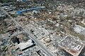
 Comparison between extratropical and tropical cyclones on surface analysis (from Cyclone)
 The dangerous semicircle is the upper-right corner, with the arrow marking the direction of motion of a Northern Hemisphere storm. Note that typhoons, etc. are asymmetrical, and semicircle is a convenient misnomer. (from Effects of tropical cyclones)
 Radar image of Hurricane Erika making landfall over Northeastern Mexico (from Tropical cyclone observation)
 Wind damage varies exponentially with wind speed, so that small increases in wind strength can dramatically increase damage. Damages rise by about a factor of four for every category increase in the Saffir–Simpson scale. (from Cyclone)
 Aerial image of destroyed houses in Tacloban, following Typhoon Haiyan (from Effects of tropical cyclones)
 Flooding in Port Arthur, Texas caused by Hurricane Harvey. Harvey was the wettest and second-costliest tropical cyclone in United States history. (from Effects of tropical cyclones)
 Surface weather map of the 1935 Labor Day hurricane moving up the west coast of Florida (from Tropical cyclone observation)
 Broken concrete utility pole in Puerto Rico after Hurricane Maria in 2017, which ranks fourth in costliest US tropical cyclones. (from Effects of tropical cyclones)
 Tropical cyclones form when the energy released by the condensation of moisture in rising air causes a positive feedback loop over warm ocean waters. (from Cyclone)
- The aftermath of Hurricane Katrina in Gulfport, Mississippi. Katrina was the costliest tropical cyclone in United States history. (from Effects of tropical cyclones)
 All but the most expensive bottles of water were sold out at this Publix supermarket before Hurricane Irma; in the week preceding the storm, water sold out soon after shipments arrived (from Tropical cyclone preparedness)
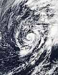

 The initial extratropical low-pressure area forms at the location of the red dot on the image. It is usually perpendicular (at a right angle to) the leaf-like cloud formation seen on satellite during the early stage of cyclogenesis. The location of the axis of the upper level jet stream is in light blue. (from Cyclone)
 A fictitious synoptic chart of an extratropical cyclone affecting the UK and Ireland. The blue arrows between isobars indicate the direction of the wind, while the "L" symbol denotes the centre of the "low". Note the occluded, cold and warm frontal boundaries. (from Cyclone)
 Effects in Buncombe County, North Carolina after Hurricane Helene passed through the area in September 2024. (from Effects of tropical cyclones)
 An example of a chart for Matthew showing its five-day forecast track (from Tropical cyclone preparedness)
 Chart with concurrent information for Hurricane Arlene and Tropical Storm Bret logged and plotted (from Tropical cyclone preparedness)
 An extratropical cyclone near Iceland (from Cyclone)
.jpg)


.jpg)


_(50).jpg)


_(cropped).jpg)


 Featured list -

The list of North Carolina hurricanes between 1900 and 1949 encompasses 75 tropical cyclones or their remnants that affected the U.S. state of North Carolina. Collectively, cyclones in North Carolina during that time period resulted in 53 total fatalities, as well as about $328 million in damage in 2008 USD. Tropical cyclone affected the state in all but nine seasons. In the 1916 season, five storms affected the state, which makes it the season with the most storms impacting the state.
The strongest hurricanes to affect the state during the time period were the 1933 Outer Banks hurricane and the 1944 Great Atlantic Hurricane, which produced winds of Category 3 status on the Saffir–Simpson hurricane scale within the state. The 1933 Outer Banks hurricane was the deadliest hurricane in the state during the time period, which killed 21 people. The remnants of a hurricane in 1940 dropped heavy rainfall in the state, which caused over $150 million in damage (2008 USD) from flooding and landslides. Most storms affected the state in September, though in the first half of the 20th century, cyclones impacted the state between May and December. (Full article...)
Topics
Subcategories

Related WikiProjects
WikiProject Tropical cyclones is the central point of coordination for Wikipedia's coverage of tropical cyclones. Feel free to help!
WikiProject Weather is the main center point of coordination for Wikipedia's coverage of meteorology in general, and the parent project of WikiProject Tropical cyclones. Three other branches of WikiProject Weather in particular share significant overlaps with WikiProject Tropical cyclones:
- The Non-tropical storms task force coordinates most of Wikipedia's coverage on extratropical cyclones, which tropical cyclones often transition into near the end of their lifespan.
- The Floods task force takes on the scope of flooding events all over the world, with rainfall from tropical cyclones a significant factor in many of them.
- WikiProject Severe weather documents the effects of extreme weather such as tornadoes, which landfalling tropical cyclones can produce.
Things you can do
 |
Here are some tasks awaiting attention:
|
Wikimedia
The following Wikimedia Foundation sister projects provide more on this subject:
-
 Commons
Free media repository -
 Wikidata
Free knowledge base -
 Wikiquote
Collection of quotations -
 Wikisource
Free-content library -
 Wikiversity
Free learning tools -
 Wikivoyage
Free travel guide -
 Wiktionary
Dictionary and thesaurus


