Talk:Territorial evolution of the United States
| This is the talk page for discussing improvements to the Territorial evolution of the United States article. This is not a forum for general discussion of the subject of the article. |
Article policies
|
| Find sources: Google (books · news · scholar · free images · WP refs) · FENS · JSTOR · TWL |
| Archives: 1, 2, 3, 4, 5, 6, 7Auto-archiving period: 28 days |
| Territorial evolution of the United States is a featured list, which means it has been identified as one of the best lists produced by the Wikipedia community. If you can update or improve it, please do so. | ||||||||||||||||||||||||||||
| This article appeared on Wikipedia's Main Page as Today's featured list on September 11, 2020. | ||||||||||||||||||||||||||||
| ||||||||||||||||||||||||||||
| Territorial evolution of the United States received a peer review by Wikipedia editors, which is now archived. It may contain ideas you can use to improve this article. |
| This article is rated FL-class on Wikipedia's content assessment scale. It is of interest to the following WikiProjects: | |||||||||||||||||||||||||||||||||||||||||||||||||||||||||||||||||||||||||||||||||||||||||||||||||||||||||||||||||||||||||||||||||||||||||||||||||||||||||||||||||||
| |||||||||||||||||||||||||||||||||||||||||||||||||||||||||||||||||||||||||||||||||||||||||||||||||||||||||||||||||||||||||||||||||||||||||||||||||||||||||||||||||||


|
Version 4
editI've been working on this in my sandbox for months, and it's time to finally put it up.
- Every single entry has been at-least quadruple checked, for accuracy, to remove assumptions, to handle any ambiguity in dating, and many other checks. Everything was given at least a secondary and primary source, if possible.
- Citations to laws and treaties, since those are often linked differently from a normal citation, were given their own section of references, with roman numeral identifiers.
- Any information on additional dates is made in a footnote; this is to finally end any and all ambiguity there might be. You have no idea how many maps will mix up, say, the date a treaty was signed, with when it took effect, with when the provisions were actually carried out, etc. Or the date a law was passed with the date it took effect.
- I tried to remove all assumptions. I think the only ones that remain involve the Western Reserve being considered part of the Northwest Territory (academic, since the question would only matter for three years) and using the dates of foreign claims to islands to consider American claims to them dormant.
- The maps were completely remade in QGIS. There are now legends built in to each image, legal citations where tidy, and, oh right, the surveys.
- So this started as a project on the colonies. As I worked on the colonial borders, it became apparent that I should not be treating any line as gospel. Not just the lines in the far west - the lines back east? Folly. When I started marking the lines as surveyed when that was noted in history - and because of how important surveying was, it was pretty well documented - I started to notice a few things, and realize a few anachronisms. And as I was documenting this, I realized... hey, wait, this is really carrying forward into the main map. I think I should do a new version of the main map based on what I've learned?
- The types of lines are: "Ideal" (dashed lines, meaning the ideal line. For latitudes, always just a simple line; for mountain ridges, I freehand clicked, because 1) it was poor form to be specific on a land survey like that, and 2) it made the dashes ugly. They're vague by definition. However, what isn't vague by definition: "River" lines. Why are these separate? Because look at the first image. It felt weird to have these dashed lines going all the way to the Mississippi, but then color the Mississippi as if it were a solidified final line. It absolutely wasn't. But, it's not a vague mountain ridge either - it's a river. You know when you've crossed it. So I decided, rivers start as blue River lines until both ends are attached to a Surveyed line, at which point the blue river joins the black survey. And, as you've gussed, "Final" ie surveyed lines.
- The surveys start to be a lot less important west of the Mississippi, but east, there are some lines that, while surveyed, weren't legally confirmed as the border until stupidly late. Because of this, instead of flooding the article with a bunch of western surveys, most of which were only dated to the year, I decided that surveys west of the Mississippi would be noted when they became a state border, unless otherwise notable, which was typically indicated by "had legislation involved".
Oh, and this is just the start. I have at least three more passes planned, to put back in some things I removed for time (like WW2 and the Wedge, Chamizal, and Country Club disputes), maritime borders, Indian treaties, and a whole list of to-do notes. But I'm really proud of where I've gotten this, and if anyone has any questions, comments, criticisms, I've been staring at this for months so it's possible I've made assumptions that other people wouldn't know just because they haven't been immersed in this. So any feedback is welcome and appreciated. :) --Golbez (talk) 17:25, 7 March 2026 (UTC)
Water Island revisited
editTime to handle Water Island. My info so far:
- In 1905, the East Asiatic Company purchased Water Island.
- The treaty to purchase the Danish West Indies specified "all territory, dominion and sovereignty, possessed, asserted or claimed by Denmark in the West Indies including the Islands of Saint Thomas, Saint John and Saint Croix together with the adjacent islands and rocks."
- The East Asiatic Company continued to operate on the island until it was purchased from them on June 19, 1944, and placed under Defense.
- It was transferred from Defense to Interior in 1952.
- Interior transferred it to USVI administration in 1996.
The primary question here is, was Water Island included in the Danish West Indies purchase? I have to assume yes.
- It's absolutely an island claimed by Denmark in the West Indies, and is absolutely an adjacent island to Saint Thomas.
- The EAC owning it does not mean it was no longer under Danish sovereignty.
- The US purchased the sovereignty, it doesn't mean they purchased the island from its owners. That kind of transfer makes perfect sense. Just because, for example, Texas joined the US, it doesn't mean any existing landowners in Texas get an independent carveout. They still own that land.
The next question: Was it part of the USVI before 1996? Again I have to assume yes.
- There was nothing specifying it as being excluded from the territory when purchased or organized.
- I have found no law adding land to a territory, which I've seen for almost every transfer.
- Administration was certainly transferred to the territory, but one interpretation of that is: When the federal government stopped running the prison, Alcatraz didn't needed to be ceded to San Francisco. When Interior stopped managing Water Island, they didn't need to formally cede it to the USVI. Plan and transfer things, sure, because you're moving administration, but the border? I don't think it moved.
So the final question is, what do we need to mention of it? I see two options. First, I thought, we could give the 1944 purchase, 1952 transfer, and 1996 transfer their own entries. But I'm not a fan of this. It makes the situation seem far more "special" than I think it actually was.
My suggested option is, we contain everything in a footnote in the 1917 USVI entry. Something like, "Water Island was privately owned at the time of the treaty, and was purchased by Defense in 1944. It was administered by Interior from 1952 to 1996, when it transferred administration to the territorial government."
Here's a great contemporary news source for the transfer, btw:
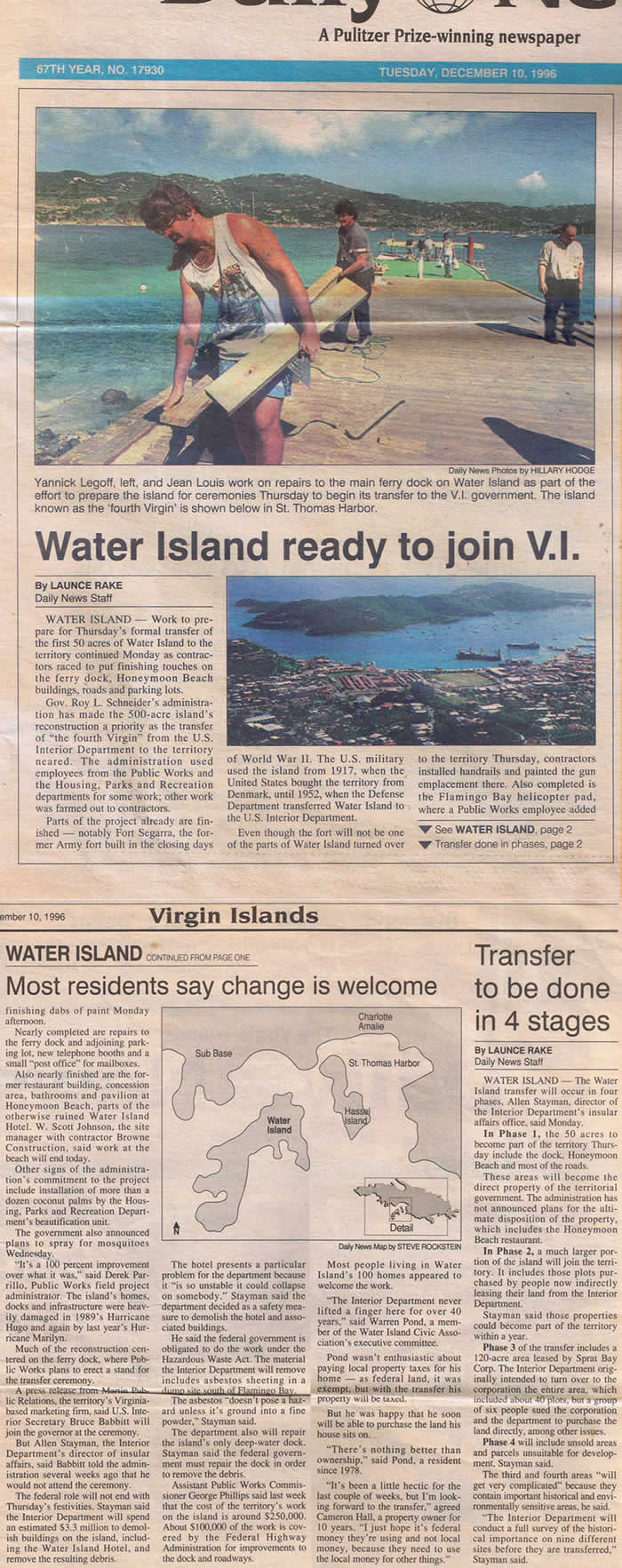
Any thoughts before I go through on this? Thanks! --Golbez (talk) 03:26, 24 March 2026 (UTC)
- @Golbez: I just noticed this thread. I have a couple of potential sources on this topic that I will check out tomorrow. (Also, as a minor nitpick, the Department of Defense didn't yet exist in 1944.) Regards, Newyorkbrad (talk) 04:01, 24 March 2026 (UTC)
- Hah, fair, I forgot about that and just parroted Water Island. --Golbez (talk) 14:18, 24 March 2026 (UTC)
- I just checked some books I have on U.S. territorial history, but unfortunately, none discuss pre-1944 sovereignty over Water Island. However, your reasoning and suggested presentation above makes sense to me. Best regards, Newyorkbrad (talk) 20:58, 24 March 2026 (UTC)
- Hah, fair, I forgot about that and just parroted Water Island. --Golbez (talk) 14:18, 24 March 2026 (UTC)
Should we change the efn type for the legal citations?
editCurrently it uses {{efn-lr}} (lower roman numerals) but i feel like it gets kind of confusing after you have several dozen of those (currently 302); they also get pretty long (longest one is [cclxxxviii]). Should we change to {{efn-ua}} (upper alpha)? E.g. [cclxxxviii] would become [KB]. —LGap (talk • edits) 13:55, 29 May 2026 (UTC)
- You can have my [fd][399][clxxxv][clxxxviii] when you pry them from my cold dead hands! ... okay, fine, yeah, that is a bit much. Not averse to it, there's no overlap in the letters (unlike the current one, which both have "i"), ... sure, why not. I'll try it out. --Golbez (talk) 15:19, 29 May 2026 (UTC)