| This is the talk page for discussing Ottoman Hungary and anything related to its purposes and tasks. This is not a forum for general discussion of the subject of the article. |
Article policies
|
| Find sources: Google (books · news · scholar · free images · WP refs) · FENS · JSTOR · TWL |
| Archives: 1Auto-archiving period: 2 months |
| The contentious topics procedure applies to this article. This article relates to the Balkans or Eastern Europe. Editors who repeatedly or seriously fail to adhere to the purpose of Wikipedia, any expected standards of behaviour, or any normal editorial process may be blocked or restricted by an administrator. |
A fact from Ottoman Hungary appeared on Wikipedia's Main Page in the Did you know column on 23 November 2006. The text of the entry was as follows:
|
| This article is rated C-class on Wikipedia's content assessment scale. It is of interest to the following WikiProjects: | |||||||||||||||||||||||||||||||||||||||||
| |||||||||||||||||||||||||||||||||||||||||


Hungarians called the Ottoman Hungary (Danube-Tisza interfluve) as Rascia in the 17th century
editDear User:OrionNimrod!
Why did you deleted the sourced material? Your reaction was a simple "I don't like it" type of editing. Especially the Danube-Tisza interfluve. The most of the Alföld region had to be re-populated and settlements had to be completely rebuild after the Ottoman wars. Unfortunately,there is no Hungarian continuity in most of Alföld cities. --Mandliners (talk) 10:39, 12 October 2024 (UTC)
- Hi Mandliners,
- my problem that you arbitrary deleted almost the entire lead section many times. Which is just a short description of the history of Ottoman Hungary. OrionNimrod (talk) 14:16, 13 October 2024 (UTC)
- It's not short! It's far too long and bloated. It's almost half the length of the History section and also covers things not in the History section which doesn't conform to WP:LEAD. DeCausa (talk) 17:15, 13 October 2024 (UTC)
- This edit by Norden1990 is an improvement which I support. DeCausa (talk) 20:04, 13 October 2024 (UTC)
It is not about the lead only. He deleted this very important info from the other sections on the basis of "I don't like it".--Mandliners (talk) 19:45, 14 October 2024 (UTC)
- No, I just copy pasted back what you deleted without deep checking all other small edits, but Norden moved those part to relevant sections. You can add your edit. OrionNimrod (talk) 21:26, 14 October 2024 (UTC)
POV of the map
editAs already discussed in the talk page of the ethnic map of Transylvania of 1495, the map has obvious NPOV issues. ZZARZY223 (talk) 11:16, 29 March 2025 (UTC)
- Hi ZZARZY223,
- It is clearly attributed the map is the modern mainstream Hungarian academic view and and their researches by the Hungarian Academy of Sciences, the top scientific institute in Hungary. So everybody know it is their academic point of view, this is the Hungarian research and view. It is clear visible that this is not a Chinese/Romanian/Brazilian source/view. Do you want to hide/remove the mainstream academic historiogaphy of an entire country regarding their own history? This is not an user painted fantasy map, this map based on 30 years of researches by many scholars and using many sources (even a lot of non Hungarian sources). The last nationwide registry in Hungary before the Ottoman period was carried out in 1494–1495 on the commission of the royal treasury. The estimated absolute or relative linguistic majority of the local population based on the family names of taxpayers recorded in national or domanial registers, the linguistic analysis of the names of geographic objects and on various scholarly sources. A really detailed research: https://emna.hu/en/map/Km_nyelvi_terszerk_1495/@46.6812151,21.2342624,7.00z The academic map fit with Wikipedia rules: https://en.wikipedia.org/wiki/Wikipedia:Attribution + Wikipedia:Verifiability + Wikipedia:Academic bias + Wikipedia:Reliable sources#Scholarship
- It is also fact by many sources/academic books that during the centuries long Ottoman and Habsburg wars the ethnic pattern of Hungary changed, as Hungary was battlefield, with many settlement and population destruction, immigration, that is why the comparison of the 2 maps.
- Regarding your linked talk page, the most absurd that you claim that Buda the Hungarian capital should be German majority in 1495 and not Hungarian majority, which means that you want to know better the demography history of the Hungarian capital than local Hungarian scholars who study this in their full life with very deep knowledge (family connections in the city, householders, every streets, disctricts, many deeps things with in very big books).
- It is your original research Wikipedia:No original research, that you claim "this city should be German/Romanian in 1495" because this is your personal opinion. It will not overwrite the Wikipedia rules, which based on reliable academic sources, and the map is attributed that is the view of Hungarian scholars about Hungarian history. The map should be not exactly which is your vision, as this is their academic research, which is properly attributed.
- Your real problem is simple, that you do not tolerate that universally Hungarian historiography do not hold "Romanians were always majority", and you have problem only with 1495 map and not with the 1784 or with the other maps from the same scholars https://hungarian-geography.hu/konyvtar/karpat-pannon2015/en/supplementary_maps.html. That map is based on researches and data, not by theories and ideologies. It is well known that Romanian and Hungarian scholars think different in many things. That is why in articles we use proper attributions "according to Hungarian historiography" / "according to Romanian historiography" / "according to X historian", respecting and providing more views.
- When you wanted to remove the map from German Wikipedia, a German user also checked deeply the map and he claimed the map is correct:
- https://de.wikipedia.org/wiki/Diskussion:Universitas_Valachorum#Kartenentfernung_durch_Benutzer:ZZARZY223
- https://de.wikipedia.org/wiki/Diskussion:Universitas_Valachorum
- Do not forget the awards which got the Atlas: https://nemzetiatlasz.hu/MNA/National-Atlas-of-Hungary_Vol3_Ch2.pdf
- The English version of the Hungarian atlas won the most prestigious professional prize in the biennial International Cartographic Conference (ICC) was held in Tokyo between 15 and 20 July 2019 by the International Cartographic Association (ICA). https://mta.hu/english/english-edition-of-the-national-atlas-of-hungary-voted-world-number-one-109950
- International Cartographic Conference 2019 (950 participants over 75 countries), that Hungarian National Atlas won the 1st award:https://icaci.org/icc2019/
- In Florence it was also the best atlas: https://www.demografia.hu/en/teszthirek/231-the-national-atlas-of-hungary-received-prestigious-recognition
- Following your logic we could mark/remove every historians texts as NPOV because we can find many other historians who think different.
- OrionNimrod (talk) 13:32, 29 March 2025 (UTC)
- Hi @OrionNimrod, like I've already replied in the other talk page, just because the map is clearly attributed to the modern mainstream Hungarian academic view doesn't mean there shouldn't be a warning that this isn't a neutral view. It's not based on a census, and giving the fact that information on the ethnic situation is very fragmented even for the larger towns, let alone thousands of small villages that just appear sporadically in few documents from that time, and the fact that nowhere in Europe scholars even make maps about the ethnic composition of a country/region in the 15 century, it should be clear to the readers of the article that there are clear NPOV issues, especially given the fact that the description of the 2 images claims that "the ethnic pattern of Hungary changed due to the centuries long wars and migration movements", and the map implies that such large changes also happened in Transylvania, view that is not universally accepted. It is not my personal opinion, nor are those observations based on original research. The map implies a level of precision and certainty that the historical evidence cannot fully support. Additionally, presenting this map in isolation gives the impression that it represents a definitive interpretation of the matter, when in fact it reflects just one viewpoint in a much broader, ongoing academic debate. For these reasons I do not see the problem in warning readers of the neutrality issues (for which this specific template exists). ZZARZY223 (talk) 16:22, 29 March 2025 (UTC)
- Hi ZZARZY223,
- follow your logic we can warn every single sentences and history maps in every single article, because many historians think different many things. The attribution is clearly show that is their view. Anyway why it would be non neutral? Because you think that you know better the population history of Hungarian capital than Hungarian scholars? You cannot blacklist the mainstream historiography of an entire country and make a warning about it. It is more extreme that you want to do this with a map which map is in an award winning atlas by International Cartographic Conference (950 participants over 75 countries).
- If you worry about neutrality, it is strange that you keep adding contents from (non modern) nationalcommunist Romanian historian Pascu, that is well known those times and those authors were cleary non neutrals. Should we mark all of this content with red waring? Btw creating fake maps is not feature in Hungary (the modern Hungarian National Atlas won international award), as Hungarian history maps are same as international history maps, but regarding nationalcommunist Romania, they produced many absurd fake maps: Romania 1400s: Romania 800-1300: those maps are very different than international history maps. So please do not make preconceptions for the Hungarian maps based on this experience.
- Do you deny that significant Hungarian settlemens/population was destroyed by centuries long Ottoman and Habsburgs wars? Do you deny that many Germans Swabian Turkey or Serbs moved Hungary after Ottoman wars? (I bet there are many German sources about German settlers in Hungary) Do you deny that Szentendre north of Budapest had Serb majority after Ottoman times? Do you deny that south Hungarian city Szarvas in Hungarian Plain was repopulated by Slovak after Ottoman wars? Do you deny the diasspaerance of Cumans from Hungary? etc... Are those things not ethnic changes? But anyway it is clearly attributed that map is the Hungarian research, should I add a repeation that "according Hungarian historiography population changed"? But German, Serb, Slovak... sources also know that new German, Serbs, Slovak cities established in many devastated area...
- Wikipedia:Neutral point of view
- ''All encyclopedic content on Wikipedia must be written from a neutral point of view (NPOV), which means representing fairly, proportionately, and, as far as possible, without editorial bias, all the significant views that have been published by reliable sources on a topic.'' + ''The neutral point of view does not mean the exclusion of certain points of view"' + "Usually, articles will contain information about the significant opinions that have been expressed about their subjects. However, these opinions should not be stated in Wikipedia's voice. Rather, they should be attributed in the text to particular sources"
- Well, the Hungarian academic map was published in a very reliable academic source, and represent the view of the entire Hungarian historiography, which is quite significant. The caption of the language is neutral as the description clearly stated that is the research and view of the Hungarian historiography regarding Hungary.
- Perhaps do you want more detailed attribution? OrionNimrod (talk) 17:25, 29 March 2025 (UTC)
- Hi @OrionNimrod, the claim that "following your logic we can warn every single sentences and history maps in every single article, because many historians think different many things." is not true because literally all historical maps that historians make represent the political situation of that time, thus the borders of countries/states in a particular period/year (like this for example), not the ethnic situation. It seems that only Hungarian historians make maps about the ethnic situation, even about thousands of small villages, in the Middle Ages/before the 19th century, when we start having censuses and data about the ethnic composition of different parts of Europe.
- Like I've replied in the discussion of the ethnic map of Transylvania, an atlas receiving international awards does not mean that every individual map within it is neutral. Those awards recognize cartographic quality and research effort, but they do not validate the neutrality of every piece of content. As an example, a map like this from a well respected German atlas about the religious situation of Europe during the year 1190 marking Transylvania as largely inhabited by Orthodox people would clearly not be neutral as Hungarian historians would obviously disagree with it. Thus, if a map based on this work was included in a Wikipedia article, there would be no problem in warning readers that it does not hold a neutral point of view (like in this case). On the other hand, a political map that represent the borders of a country in a particular year is not problematic, since the vast majority of historians typically don't disagree with it (and if there are significant disagreements about the said map there should be a template that warns readers about this). The absourd maps you linked are not used anywhere in Wikipedia.
- You are bringing up again Pascu despite I simply used his work to cite a Latin text. But again, what he wrote in that part of his work is confirmed also by other sources (about Deva and Hațeg being seats of Vlach districts), like those: "dictorum populorum in districtibus Olachalibus castri nostri Dewa (1427) source, tamen universi kenezii et Olachi de quatuor sedibus districtibus castri Deva (1371) source, Kenezius olachorum de districtu castri Hathzak (1377) source, coram nobis et regni nobilibus de comitatu Hunyad ac universis Kcneziis et senioribus Olachalibus districtus Hatzag (1363) source. Just like said before, not everything he wrote should be considered unreliable just because he was, as you call him, a "national-communist" author.
- Still, like I've noticed in the talk section of the Transylvania 1495 map, this work is obviously biased to mark as Hungarian-majority as many settlements as possible, including villages that appear with the name "Olah" or even villages that didn't exist in 1495. And even if we assume Buda was Hungarian-majority in 1495, there's no actual way to determine this as an accurate fact, since we don't have precise data about the ethnic situation for that time (as anywhere else in Europe in places where we have a multi-ethnic context). Even about Cluj, Balázs A. Szelényi says in this work "The Magyar and German conflict within the towns did increase in the late fifteenth century, when concurrently there were more Magyars moving in. It was at this time that Magyars reached a majority in Kosice and Cluj." But then adds "Cluj in the fifteenth century had a German majority, in the sixteenth Magyar, and then quickly back to German, and from the late sixteenth century, the Magyars enjoyed a continuous majority." So again, given this fluctuation of the ethnic groups in the city there's no way to determine which group was exactly the majority in the year 1495, let alone the ethnic situation in thousands of small villages that during the 15 century appear sporadically in documents.
- Furthermore, the map obviously implies that the ethnic composition of Transylvania had a major shift from 1495 to 1784, which is not a neutral point of view, as the description of the 2 images here says: "The ethnic pattern of Hungary changed due to the centuries long wars and migration movements.", and implying this happened in Transylvania as well.
- The neutral point of view rule claims editors should "Avoid stating seriously contested assertions as facts. If different reliable sources make conflicting assertions about a matter, treat these assertions as opinions rather than facts, and do not present them as direct statements.". About the undue weight, it claims: "Neutrality requires that mainspace articles and pages fairly represent all significant viewpoints that have been published by reliable sources, in proportion to the prominence of each viewpoint in those sources. [..] Undue weight can be given in several ways, including but not limited to the depth of detail, the quantity of text, prominence of placement, the juxtaposition of statements, and the use of imagery." And given the fact that this is indeed a work made by a very reliable academic source like the Hungarian Academy of Sciences, but still does not hold a neutral point of view (as it is based on estimates and assumptions contested by Romanian scholars), readers should be advised about this fact. ZZARZY223 (talk) 17:11, 31 March 2025 (UTC)
- Hi @OrionNimrod, like I've already replied in the other talk page, just because the map is clearly attributed to the modern mainstream Hungarian academic view doesn't mean there shouldn't be a warning that this isn't a neutral view. It's not based on a census, and giving the fact that information on the ethnic situation is very fragmented even for the larger towns, let alone thousands of small villages that just appear sporadically in few documents from that time, and the fact that nowhere in Europe scholars even make maps about the ethnic composition of a country/region in the 15 century, it should be clear to the readers of the article that there are clear NPOV issues, especially given the fact that the description of the 2 images claims that "the ethnic pattern of Hungary changed due to the centuries long wars and migration movements", and the map implies that such large changes also happened in Transylvania, view that is not universally accepted. It is not my personal opinion, nor are those observations based on original research. The map implies a level of precision and certainty that the historical evidence cannot fully support. Additionally, presenting this map in isolation gives the impression that it represents a definitive interpretation of the matter, when in fact it reflects just one viewpoint in a much broader, ongoing academic debate. For these reasons I do not see the problem in warning readers of the neutrality issues (for which this specific template exists). ZZARZY223 (talk) 16:22, 29 March 2025 (UTC)
- The map is biased towards the Hungarian POV. There already was a long discussion about this in which several deficiencies in the map's making were pointed out. It is not possible to make a village-to-village ethnic map of 1495 and to pretend otherwise is an insult to the exercise of history. The map should be removed from Wikipedia. Super Ψ Dro 14:55, 2 April 2025 (UTC)
- I've also noticed many problems in the talk page about this map. No historians anywhere outside of Hungary even make maps about the ethnic situation before the 19 century. ZZARZY223 (talk) 15:43, 4 April 2025 (UTC)
- @ZZARZY223 I would suggest removing the map. The issues with it were discussed before, and the outcome was that it failed NPOV. There is no need to go through them again. Aristeus01 (talk) 17:43, 2 April 2025 (UTC)
- Hello, That is the mainstream academic historiography about history of Hungary = Hungarian historiography point of viewpoint (POV) which cannot be cenzored (this is not an user painted fantasy map). In this article, it demonstrates how population of Hungary changed during the centuries long wartime, it was always very important thing in the Hungarian historiography. It shows many important things about Cumans, Germans, etc in Hungary like the above linked in German Wikipedia, a German user claimed the map is ok correct when he checked many details. This academic map fits with Wikipedia rules: https://en.wikipedia.org/wiki/Wikipedia:Attribution + Wikipedia:Verifiability + Wikipedia:Academic bias + Wikipedia:Reliable sources#Scholarship It is clearly attributed that is their research, it is clear and understandable that this is not Romanian/British/Russian/Chinese... research, so everybody can see that is Hungarian POV based by Hungarian research.
- Wikipedia:Neutral point of view: ''The neutral point of view does not mean the exclusion of certain points of view"'
- Follow this "removal logic" we could remove hundreds of Romanian or hundreds of Hungarian historiography from Wikipedia, just because Hungarian user can say this "Romanian historiography is Romanian POV", and Romanian user can say this "Hungarian historiography is Hungarian POV"... that is why we started to attribute contents like "according to Hungarian historiography" or "according to Romanian historiography" or "according to X historian" so everybody can see which historians or historiography makes that claim, that is a normal thing that there are many different views regarding many historical things. OrionNimrod (talk) 18:25, 2 April 2025 (UTC)
- We should remove any maps if they are biased, whether they are towards the Romanian or the Hungarian POV.
- Because our last discussion was very lengthy and unproductive, I would suggest holding a RfC, prioritising the intervention of editors from outside the topic area, and guaranteeing beforehand that we (editors involved in the topic area) won't WP:BLUDGEON the discussion with lots of paragraphs and scare away outsider editors with unbiased opinions. Just a suggestion, I wouldn't mean to start one right now. Super Ψ Dro 18:47, 2 April 2025 (UTC)
- A map or text, it does not matter, it is still the very modern academic mainstream Hungarian historiography, morover the map also presented in the international award winner National Atlas, which cleary demonstrate the international recogniton of the atlas which made by big work by many scholars. This academic work fits with Wikipedia rules. It is not possible to censor a historiography of an entire country. Hungary was very multiethnic in 19th century (like other countries) The population research is a very important thing in the Hungarian historiography, during Ottoman and Habsburg times the population changes, settlement destructions, Croatian areas also changed during Ottoman times. I do not think it should hide that Hungary was destroyed and Hungarian population was decimated during the long wartime as Hungary became a battlefield, and Hungarian historiography know about that. I do not think that Germans had problem that they settled many areas in Hungary, and even refounded Buda after Mongol invasion, expelled from Buda after Mohacs, and repopulated Buda again after the Ottomans, and many other areas. Or Cumans in Hungary. Or that north from Budapest Szentendre became a Serb settlement, Serb church there : Or Kópháza next Austrian border had many Croatians still today or Szarvas far from Slovak area became Slovak city...
- It is absurd that ZZARZY223 claims that he wants to know better the population of history of Hungarian capital than academic Hungarian scholars, to claim the map is not correct there...
- It seems only Romanian users fight ardently always to remove the Hungarian map, it seems they do not care about the settlement research of Hungary, or about the German settlements and others in Hungary, which clearly show that they have actually the bias, as this is not fit with "always majority Romanians" in Transylvania story. It is well known that Hungarian view is different. Outsider German editor clearly claimed the map is correct after he checked details:
- https://de.wikipedia.org/wiki/Diskussion:Universitas_Valachorum#Kartenentfernung_durch_Benutzer:ZZARZY223
- https://de.wikipedia.org/wiki/Diskussion:Universitas_Valachorum#Zur_Karte
- I believe in Wikipedia, we can fairly present both Hungarian and Romanian academic historiography, even if they think different in many things, like there are many hot topics everywhere in the world. That is why we are using attributions, so the readers can see the source of the claim. OrionNimrod (talk) 20:48, 2 April 2025 (UTC)
- Even in the discussion on German Wikipedia you linked it is clear from everything said there that the map has many problems. About Buda, I simply claimed that different historians make different claims about the ethnic situation of the city during that time, since we simply don't have data to claim with certainty which group was the majority during that time. The map is indeed problematic, as like mentioned before, it is biased to mark as Hungarian-majority as many settlements as possible, even settlements that didn't exist in 1495. There's also the fact that no other historians outside of Hungary even make maps about the ethnic situation, of any country or region, before the 19 century. In conclusion, while it is fair that the views of both Romanian and Hungarian historiographies can be present in a Wikipedia article, it is also fair to draw attention to the fact that content like this can have critical issues with its reliability. ZZARZY223 (talk) 15:12, 4 April 2025 (UTC)
- Hi @Aristeus01, I agree with you about the fact that this file has many problems, as I've also noticed in the talk page about this map. I've started this discussion because OrionNimrod removed the disputed map template which was present before. ZZARZY223 (talk) 15:18, 4 April 2025 (UTC)
- ZZARZY223 only you assumed problems there, the German user confirmed the good quality of the map. Do you claim Hungarian academic research by Hungarian Academy of Science about Hungarian settlements was made by bad faith? Then why did the Atlas get international recognition many times? Do you think do you have deeper knowledge than Hungarian academic scholars regarding settlement structure/history of Hungary? Which settlement did not exist in 1495 which marked as exist? This 1495 image jpg map is not the interactive map, where the background is just a Google satellite map with today settlements, that is just a background layer, dont surprise that you can see today settlements in the Google map... Regarding Hungarian capital Buda, you just repeat that was refunded by German colonist after Mongolian invasion and it had German majority, yes Hungarian scholars all know this, but plenty historian work (what I showed in that talk page) shows that in the 15th century the ethnic composition of Buda changed. Still absurd that you claim you know better the Hungarian capital than Hungarian academic scholars, Wikipedia based on academic contents, not our personal belief. Basically, you claim if a city has X majority population in 1400 according to your personal preconception it cannot be Y majority in 1500 (medieval cities like Buda has just about 10-15,000 people, others more less, medieval cities always needed immigration because epidemics, etc (I have read those in that sources)). It was also many wars and settlement destructions centuries long. Population can change fast, like Oradea, Cluj... etc former Hungarian populated cities were romanianized just some decades in a very short time. Do you see how population can change fast? I could tell you hundreds of examples of population change in the world in many areas.
- Should we make warning also for Romanian historian sources that they not reliable? It is clear and understandable that this map is not Romanian/British/Russian/Chinese... but a Hungarian research, so the readers can see the source of the claim. Is this not clear? OrionNimrod (talk) 17:04, 4 April 2025 (UTC)
- ZZARZY223 Your behavior is strange as you pretend you deeply worry about "neutrality", but you started to rewrite other language Wikipedia articles regarding the similar topic. Spreading exclusively Romanian narrative and removing other narrative: you rewrote in Gesta Hungarorum Gelou from "Vlach" to "Romanian", you removed the fact (sourced content) that this is a controversal issue that romanized population left or not (Then why many users and historians are debate about this all the time? Why do you deny even our debate?), you removed the contemporary Vasile Lupu estimation about 1/3 Romanians, while you added estimation about 60% Romanians as fact not naming the opinion https://pt.wikipedia.org/w/index.php?title=Transilvânia&diff=prev&oldid=69684219 Is this your Wikipedia campaign, removing every single things which is not the Romanian nationalist narrative? Do you have the same real purpose with the Hungarian map that is why you attack everywhere? Claiming a 60% Romanians estimation as fact in 1600 is ok? But saying an estimated map based a Hungarian academic research just simple bad? Is this your neutrality? At least I have no problem to present more academic views... OrionNimrod (talk) 00:00, 5 April 2025 (UTC)
- @OrionNimrod On the Portuguese Wikipedia I simply corrected the extrapolated translation of Antun Vrancic's phrase, which had been used along with a cherry-picked quote from Vasile Lupu to justify the claim that the region’s ethnic composition shifted to a Romanian majority (a claim supported only by Hungarian historians) and completely ignoring other sources from that century that state otherwise. Also I don't see what is wrong with chaning Vlach with Romanian since are basically synonyms in this historical time, and the name Vlach was not used in the text before. ZZARZY223 (talk) 20:03, 11 April 2025 (UTC)
- ZZARZY223 Your behavior is strange as you pretend you deeply worry about "neutrality", but you started to rewrite other language Wikipedia articles regarding the similar topic. Spreading exclusively Romanian narrative and removing other narrative: you rewrote in Gesta Hungarorum Gelou from "Vlach" to "Romanian", you removed the fact (sourced content) that this is a controversal issue that romanized population left or not (Then why many users and historians are debate about this all the time? Why do you deny even our debate?), you removed the contemporary Vasile Lupu estimation about 1/3 Romanians, while you added estimation about 60% Romanians as fact not naming the opinion https://pt.wikipedia.org/w/index.php?title=Transilvânia&diff=prev&oldid=69684219 Is this your Wikipedia campaign, removing every single things which is not the Romanian nationalist narrative? Do you have the same real purpose with the Hungarian map that is why you attack everywhere? Claiming a 60% Romanians estimation as fact in 1600 is ok? But saying an estimated map based a Hungarian academic research just simple bad? Is this your neutrality? At least I have no problem to present more academic views... OrionNimrod (talk) 00:00, 5 April 2025 (UTC)
- Hi @ZZARZY223! Yes, many, many problems. Not only about the map itself but also the way it is presented here on Wikipedia:
- the map is the work of several authors, members of the Geographical Institute, and not of the Hungarian Academy of Science as a whole.
- the map did not receive international prizes. The prize some editors (incorrectly) refer to was for the National Atlas of Hungary volume 2 which describes the natural environment of the country (lithosphere, hydrosphere and atmosphere, biosphere). The map is, to my understanding, from volume 3 "Society" which did not receive such international recognition.
- in fact, the map did not even seem to stir much interest in the academic community, and it is mainly promoted outside it. Aristeus01 (talk) 18:22, 4 April 2025 (UTC)
- Hi Aristeus01, "many"? Your problem is simple political, that this is a Hungarian map, and you want hide the modern Hungarian academic research and historiography/viewpoint about Hungarian history and settlements, and ethnic history of Hungarians. As we can see only Romanian users ardently wants always to remove, as the map does not fit the "always majority Romanians in Transylvania" Romanian ideology. It would be fair if you would admit the real reason. It is well known that Hungarian historiography is very different regarding that, so what is so suprising? First you tried delete by copyright in hard contrast in other case interesting that you did not find "many" problems with an another old map where full Hungarian kingdom, Croatia, today Slovakia, east Austria are full with Romanian settlements 800-1400: Or do you think only the biased works of Pop Aurel (as you use his works many times) is allowed to publish in Wikipedia, and Hungarian academics not allowed?
- Geographical Institute is part of Hungarian Academy of Science (MTA in Hungarian) https://hungarian-geography.hu/konyvtar/karpat-pannon2015/en/index.html the map which is in Commons was made in 2015: MTA research Centre for Astronomy and Earth Sciences, Geographical Institute
- Sorry, I do not follow how academic institute structures every year reorganize themselv.
- https://www.mtafki.hu + https://hungarian-geography.hu/about-us.html The Hungarian Academy of Sciences has been the higher authority supervising and inspecting the Institute since the foundation of the latte... The Hungarian Academy of Sciences (MTA) integrated our Institute into the Centre for Astronomy and Earth Sciences in 2011. The Institute of Geography has been part of the Eötvös Loránd Research Network (ELKH) since 2019 and the Hungarian Research Network (HUN-REN) since 2023.
- I see National Atlas of Hungary Volume 2 - Natural environment got the award in Tokyo Cartographic conference https://mta.hu/english/english-edition-of-the-national-atlas-of-hungary-voted-world-number-one-109950 but the same academic authors and institute created the other volumes as well.
- I did not say the map got award, I said the Atlas got award where the same map was published. The National Atlas of Hungary Volume 3 - Society also got an award in Florence Cartographic conference where is the ethnic map published: https://www.demografia.hu/hu/letoltes/hirek/MNA%20Tarsadalom%20kotet%20oklevel.jpg
- The map is part of National Atlas (this got an award in Florence) https://nemzetiatlasz.hu/MNA/3_en.html just the design is different: https://nemzetiatlasz.hu/MNA/National-Atlas-of-Hungary_Vol3_Ch2.pdf
- Eötvös Loránd Research Network (ELKH), Research Centre for Astronomy and Earth Sciences (CSFK), www.csfk.org © Geographical Institute, CSFK www.mtafki.hu, Budapest, 2021
- The map again used in the National Atlas of Hungary Volume 1 - State and Nation, just again with different design: https://nemzetiatlasz.hu/MNA/National-Atlas-of-Hungary_Vol1_Ch7.pdf If you like it or not, but that is the Hungarian historiography about Hungarians and Hungary.
- Hungarian Research Network (HUN-REN) Research Centre for Astronomy and Earth Sciences (CSFK), www.csfk.org © Geographical Institute, CSFK www.mtafki.hu, Budapest, 2024
- https://mta.hu/english/new-volume-of-hungarian-national-atlas-now-available-in-english-109258
- This Atlas is a huge project started in 2013 with a lot of institution and scholars: https://atlas.icaci.org/wp-content/uploads/2021_icc_gercsak_national_atlas_of_hungary_ppt.pdf
- It made by many scholars and academic people, published by top academic institutions which fits with Wikipedia rules. I can add a better attribution like "estimated ethnic map". OrionNimrod (talk) 19:51, 4 April 2025 (UTC)
- I'm not even going to attempt to discuss all those largely tangential opinions and misrepresentations of facts. Please keep in mind we are here to talk with the purpose of improving the article, not Wikipedia:BATTLEGROUND. What I take out of it is that you agree the map is not part of the prize wining volume it was initially presented to be. I also see you changed that part and now you are saying the Atlas did win a prize. I kindly remind you that was a prize by "people vote", ie not the choice of the society itself, so not on the podium, and it was for the volume (section atlases) and not for the maps presented in this article in particular. Aristeus01 (talk) 09:57, 5 April 2025 (UTC)
- Hi Aristeus01, I mentioned the awards only, because some users "worried" about the quality of the academic Hungarian work about Hungary. I always said the Atlas won the prize. As you can see this is a huge project started 2013, it will be 4 volumes, made by the same authors and institutions. The second volume voted number one in Tokyo Cartographic conference. The thrid volume, (where the 1495 map is presented with different design, but the research/result is same) got also an award by professional people in the conference (not by random people): https://www.demografia.hu/en/teszthirek/231-the-national-atlas-of-hungary-received-prestigious-recognition: The book entitled The National Atlas of Hungary, presented in Hungary in the autumn, was the best among the professional audience at the International Cartographic Association's conference in Florence. The MNA project, implemented with extensive cooperation, was initiated by the Hungarian Academy of Sciences and is supported by the Central Statistical Office as a strategic partner.
- Even if the Atlas has not won any awards yet, it is still a modern mainstream academic piece of work, made by many scholars and instituitons. Have any of the historical source works you have cited in articles won international awards? OrionNimrod (talk) 10:41, 5 April 2025 (UTC)
- @OrionNimrod How do you know how and by whom the third volume was voted? Aristeus01 (talk) 11:05, 5 April 2025 (UTC)
- @Aristeus01 https://www.demografia.hu/en/teszthirek/231-the-national-atlas-of-hungary-received-prestigious-recognition: The book entitled The National Atlas of Hungary, presented in Hungary in the autumn, was the best among the professional audience at the International Cartographic Association's conference in Florence." The conference has many categories (each has 1st, 2nd, 3rd, popular vote awards) The 30th International Cartographic Conference took place in Florence, Italy, 14–18 December 2021 (630 participants from 53 countries) https://icaci.org/files/documents/ICC_proceedings/ICC2021/ICC2021_final_slides_LOC.pdf + https://icaci.org/files/documents/ICC_proceedings/ICC2021/ICC2021_MEC.pdf. Result: https://icaci.org/icc2021/ Popular vote: National Atlas of Hungary – Society, Hungary: https://nemzetiatlasz.hu/MNA/3_en.html the same map in the chapter 3: https://nemzetiatlasz.hu/MNA/National-Atlas-of-Hungary_Vol3_Ch2.pdf
- The Department of Cartography and Geoinformatics of Eötvös Loránd University (ELTE) is also part of the project, this is the number 1 most prestigious University in Hungary (and this university is inside in top 2% in global): https://www.elte.hu/en/about-elte OrionNimrod (talk) 11:22, 5 April 2025 (UTC)
- Again, please verify the sources and "facts" you are citing. The ICA itself say in its guideline:
- "In addition to the on-site exhibition, it is expected that there will be a parallel gallery of the exhibits on the Internet. Especially in the case of a hybrid or virtual conference, this is essential. On the website of the online gallery, there should also be a possibility to participate virtually in the selection of awards for the best objects via a 'popular vote'" (page 21)
- That means the vote for the prize was done most likely by an online public of both professionals and amateurs, and "the best among the professional audience at the International Cartographic Association's conference in Florence" is just peacock language used for self-promotion (if not downright misleading information).
- Given this, your arguments only reinforced my above points:
- the map did not receive international prizes. The prize some editors (incorrectly) refer to was for the National Atlas of Hungary volume 2 which describes the natural environment of the country (lithosphere, hydrosphere and atmosphere, biosphere). The map is, to my understanding, from volume 3 "Society" which did not receive such international recognition.
- in fact, the map did not even seem to stir much interest in the academic community, and it is mainly promoted outside it.
- Aristeus01 (talk) 11:50, 5 April 2025 (UTC)
- Aristeus01, "amateurs"? The academic institute website clearly say, only professional audience voted: https://www.demografia.hu/en/teszthirek/231-the-national-atlas-of-hungary-received-prestigious-recognition
- Your motivation is clear, your campaing just simple to degradate Hungarian sources and academics, even you claim the academic Hungarian institute "spread misinformation".
- https://icaci.org/icc2021/ 630 participants from 53 countries, whereof 49% in presence = 51% was online At page 11, you can see the participant, many was online (of course they voted online, if they were not there... it was the Covid period): https://icaci.org/files/documents/ICC_proceedings/ICC2021/ICC2021_final_slides_LOC.pdf
- Why do you deny that National Atlas of Hungary volume 2 also got an award? https://www.demografia.hu/hu/letoltes/hirek/MNA%20Tarsadalom%20kotet%20oklevel.jpg This is really no my problem if you do not like that cerfiticate or you want deliberately underestimate it.
- Well, I did not say the map got international award, I said the Atlas got award where is in the map. (And the other Atlas would the number 1 award whitht he same authors)
- The Ottoman/Habsburg times, and the desctruciton, the popultion change by those wars is a well researched topic in Hungary: https://icaci.org/files/documents/ICC_proceedings/ICC2021/ICC2021_MEC.pdf page 137: The Society volume of the National Atlas of Hungary focuses on the dynamic spatial structure of society not merely for Hungary, but wherever the required data are available, for the entire Carpathian Basin, thus covering 34 thousand settlements in twelve countries. The more than 345 maps present changes in the numbers of the population
- In reality, you did not care at all about the quality of these researches, historians, institutions. Based on our previous experience. It would be fair to admit your real problem, that you do not like to presenting the Hungarian historiography because it is different than your Romanian view, and you want cenzor/blacklist the Hungarian narrative (that is why you wanted delete even from Commons) and you want to show exclusively Romanian narrative about Hungarian history. That is.
- Even if the Atlas has not won any awards yet, it is still a modern mainstream academic piece of work, made by many scholars and top institutions.
- You did not answer my previous question: Have any of the Romanian historical source works you have cited in articles won international awards? How many international awards won your cited Pop Aurel works or your Draganu map? Why were not you this critical with them? Were you this critical of your cited authors, as you were with the Hungarian one, why do you want diminish Hungarian sources? OrionNimrod (talk) 12:32, 5 April 2025 (UTC)
- @OrionNimrod I'm neither interested nor obliged to answer off-topic questions and/or personal opinions. The discussion was around the supporting arguments for the two maps, about which my observations are valid, as shown. Else, all the best to you! Aristeus01 (talk) 12:45, 5 April 2025 (UTC)
- @ Aristeus01, I just reacted for you personal untrue opinions about the Hungarian Atlas: "Society volume did not recieve international recogniton", "amateurs voted" "self-promotion if not downright misleading information". That is why I think it would be honest to admit the real purpose why Romanian users always ardently fight against this map. However we all know why...
- But if it would be no any awards, the content is still top academic modern source. I just hope you use similar quality sources in your articles. OrionNimrod (talk) 13:04, 5 April 2025 (UTC)
- @OrionNimrod That is very Don Quixote of you. In reality, the points I made are:
- Volume 3 (and the maps) did not receive the international recognition volume 2 did, so it is wrong to use the last to promote the first.
- and those who voted for the "people's award" were participants, including children who added drawings and young people with scholarships. Are you suggesting they are also professional attendance? Perhaps ICA is using child labour?
- Aristeus01 (talk) 13:28, 5 April 2025 (UTC)
- @Aristeus01
- What is this if not an international recognition? Certificate, Volume 2 Society: https://www.demografia.hu/hu/letoltes/hirek/MNA%20Tarsadalom%20kotet%20oklevel.jpg not by amaterus (51% conference member was online, probably because of Covid in 2021) "was the best among the professional audience at the International Cartographic Association's conference in Florence" https://www.demografia.hu/en/teszthirek/231-the-national-atlas-of-hungary-received-prestigious-recognition
- https://mta.hu/english/english-edition-of-the-national-atlas-of-hungary-voted-world-number-one-109950 "The most prestigious professional cartographic conference"
- I think it is your personal problem that you to degrade the International Cartographic Association https://icaci.org (Because a Hungarian academic works got awards by them, of course you feel you need make a defamatory campaign against the international institute)
- But if it would be no any awards, it does not matter, the Hungarian Atlas, and maps are still top academic modern source. I just hope you use similar quality sources in your articles. OrionNimrod (talk) 13:42, 5 April 2025 (UTC)
- @OrionNimrod nonsense. Aristeus01 (talk) 13:46, 5 April 2025 (UTC)
- @Aristeus01 The awarded certificate is nonsense or the International Cartographic Association is nonsense? Please consult with them that you assume they use child labor... :) OrionNimrod (talk) 13:48, 5 April 2025 (UTC)
- @OrionNimrod The reasoning in the previous reply is nonsense because:
- You can not use the award for a study to justify the content in another study, as you imply.
- The participants are not the jury, they are not even all professionals. Check the lists in the file.
- your opinion about my intentions and what I think of ICA is not worthy of remarks.
- claiming your Hungarian sources are good and modern, and my sources or Romanian sources are not is just nonsense.
- Aristeus01 (talk) 14:06, 5 April 2025 (UTC)
- @Aristeus01
- As I demonstrated that is a long project. The award was just an example, of course the Atlas got awards not the map, but the same 1495 map was published also in the award winner Atlas (same accompanying text, demographic research/result, just with different colors/design). Again, it is not my problem if you degrade the participants "not professional" of an international conference, the linked site cleary says "pofessionals voted". But it does not matter. The map was made by academic scholars and top institutions.
- Your intention is not irrevelant as you are ardently always make a cross wiki fightning a long time ago against this map.
- "claiming your Hungarian sources are good and modern, and my sources or Romanian sources are not is just nonsense."
- Actually Romanian users like you claiming the academic Hungarian sources are not good (basically claiming not allowed to use) about Hungarian history (that is the nonsense). But many times I experienced that you removed even non-Hungarian academic sources which not supported your Romanian narrative. I just said I hope you use similar academic sources in your articles, I just said I wonder if you are as critical of the Romanian sources as you are of the Hungarian ones? I always said using attribution is the solution to present different academic viewpoints, and not removing them just because A dont like historiography of B and B dont like historiography of A. OrionNimrod (talk) 14:46, 5 April 2025 (UTC)
- "Actually Romanian users like you claiming the academic Hungarian sources are not good (basically claiming not allowed to use) about Hungarian history (that is the nonsense)."
- I used far more Hungarian sources than you used Romanian. Your final claims here are not derived from facts, just baseless accusations. The problem is that you continue to use sources that seem to confirm certain opinions and beliefs, particularly about history, and ignore those who say otherwise. If that wasn't true, next to the maps in this article you would have added the prevailing opposite view as well. It is not the responsibility of other editors to balance your POV:
- " Editors, while naturally having their own points of view, should strive in good faith to provide complete information and not to promote one particular point of view over another."
- It is your responsibility "to provide complete information and not to promote one particular point of view over another."
- And that is just the beginning of the problems with the map that you are trying to force on wiki pages despite the protest from other editors. Aristeus01 (talk) 09:06, 6 April 2025 (UTC)
- Aristeus01, I present modern mainstream academic Hungarian historiography about Hungary with proper attribution Wikipedia:Reliable sources#Scholarship, and only Romanian users like you do not like that, as you want hide Hungarian historiography at any cost, as you cannot tolerate different view than yours, because your goal is just present exclusively the Romanian narrative about Hungary. Sorry but this is not the communist times. Your real problem that you want see more Romanian areas in the map, (even if this not supported by this research), because "always majority Romanians in Transylvania" slogan is popular in Romania. Also, do not need pretend that you worry too much about more points of view, as you many times removed the different views from articles than your views, keeping only your views there.
- Please tell me which attribution of the map would be better? "Estimation of ethnics by Hungarian academy by their research?" It is not promoted over any view, as this is one attributed research, then everybody can see this is the Hungarian view/Hungarian POV and estimation, in this way it is not claimed as universal fact.
- What do you expect exatcly? Find an another modern map which say Sopron was not German majority, Szarvas was not Slovak majority, Szentendre was not Serb majority, Kiskunhalas was not Cuman majority, Kolozsvar/Cluj was not Hungarian majority, Hermannstadt/Sibiu was not German majority...? etc
- You alway shout "Hungarian POV" + "many many many many problems :D" + "Hungarian Academy is not Hungarian Academy" + "Hungarian academic statements about professional audience just selfpromotion mislead" + "I always said the Atlas got award (where the map was republished), but you keep repeating the map did not get award what I never said" + "showing many times the certificate, but you keep deny the award of the atlas" + "according to you the International Cartographic Association are amaterus childs, accusing them with child labor" What next? The authors of the map drink too much cofee? like a comedy show... should I do the same behavior every of your Romanian POV content? I wonder if you are as critical of your Romanian sources (which is Romanian POV) as you are of the Hungarian ones. OrionNimrod (talk) 10:13, 6 April 2025 (UTC)
- @OrionNimrod Your obsession with the other editor's ethnicity clearly show that your refusal to accept consensus is ethnically and not logically motivated. Simply put, you don't want to agree with the other editors because they are Romanians.
- What I expect exactly is that the maps are not used on Wikipedia, as per the arguments presented by the other editors, mainly that a village by village representation of ethnicity in the 15th century is a violation of the science of history and an insult to reason.
- The rest of your text does not add any value to the discussion. Aristeus01 (talk) 11:22, 6 April 2025 (UTC)
- @OrionNimrod The reasoning in the previous reply is nonsense because:
- @Aristeus01 The awarded certificate is nonsense or the International Cartographic Association is nonsense? Please consult with them that you assume they use child labor... :) OrionNimrod (talk) 13:48, 5 April 2025 (UTC)
- @OrionNimrod nonsense. Aristeus01 (talk) 13:46, 5 April 2025 (UTC)
- @OrionNimrod That is very Don Quixote of you. In reality, the points I made are:
- @OrionNimrod I'm neither interested nor obliged to answer off-topic questions and/or personal opinions. The discussion was around the supporting arguments for the two maps, about which my observations are valid, as shown. Else, all the best to you! Aristeus01 (talk) 12:45, 5 April 2025 (UTC)
- @OrionNimrod How do you know how and by whom the third volume was voted? Aristeus01 (talk) 11:05, 5 April 2025 (UTC)
- I'm not even going to attempt to discuss all those largely tangential opinions and misrepresentations of facts. Please keep in mind we are here to talk with the purpose of improving the article, not Wikipedia:BATTLEGROUND. What I take out of it is that you agree the map is not part of the prize wining volume it was initially presented to be. I also see you changed that part and now you are saying the Atlas did win a prize. I kindly remind you that was a prize by "people vote", ie not the choice of the society itself, so not on the podium, and it was for the volume (section atlases) and not for the maps presented in this article in particular. Aristeus01 (talk) 09:57, 5 April 2025 (UTC)
- Aristeus01 Your obsession over the years always against Hungarian academic sources shows the ethnic motivations. The modern academic map fits Wikipedia rules Wikipedia:Reliable sources#Scholarship, you are not the cenzor of academic contents, and to remove the historiographical knwoledge and research of any entire country about his own country. The professional academic International Cartographic Association and international professional participants (but of course you degreaded this like every other things) awarded the Atlas, where this map was republished, so "violation of the science of history and an insult to reason" is your personal opinion again to degrade Hungarian scholars. Every settlements in the world have history and population history by scholars like "Celts lived here, Slavs lived here, Germans lived here, Romanians lived here, Hungarians lived here in X time", but you claim that is violation of science :) I did not know that Hermannstadt/Sibiu was a German majority city in 1495 is a violation of the science of history :) It seems you want to determine which researches are allowed by scholars... it is far more deeper research than using random estimations by different historians who say the region was like 70% Romanian in 1300, or 30% Romanian in 1600... all of this are different scholar views. OrionNimrod (talk) 11:58, 6 April 2025 (UTC)
- @OrionNimrod Again, I have no problem with any sources as long as they are reliable. See, for example, my use of Tivadar Vida's papers. Please tell me when did you use Romanian sources? Probably never, because you hate Romanians, and that is what all this is about.
- What is problematic is the crude attempts to distort reality by cherrypicking sources and presenting them as mainstream and internationally acclaimed despite evidence to the contrary. I am starting to doubt we have the same understanding about RS. Could you please tell us what a RS source is for you and elaborate on what Romanian and Hungarian sources you find reliable?
- I think it is probably best to show you are the bigger man and give up on pushing this unreliable POV maps with which no one seems to agree. In the end, we are here to make the article better, so please give us a proof you are comitted to that by removing this poor quality content. Aristeus01 (talk) 12:42, 6 April 2025 (UTC)
- @Aristeus01, I deeply condemn hatred, please do not put words in my mouth. I do not think an atlas would be a hate speech.
- Actually you attacked again the same Hungarian source, you are always against Hungarian sources, you constantly abuse and degrade a lot of academic Hungarian scholars claiming their 30 years of research is "poor quality" "unreliable" "violance of science", you degrade the top Hungarian academic institutions and even the International Cartographic Association that you claimed they are "child abusers" just because Hungarian Atlas volume 2 got the 1st award and in another year the volume 3 Society got the 4th award made by the same Hungarian academics, those scholars you insult by giving them poor work. That is not my problem that International Cartographic Association awarded the Atlas and you do not like this deed.
- I mention this only, just because those ethnic maps are republished in that volume 3, those you disparage. International Cartographic Association also first supervise and approve which works are published in the conference. It was clear for every academics that Hungarian Atlas is about society and ethnic changes: https://icaci.org/files/documents/ICC_proceedings/ICC2021/ICC2021_MEC.pdf page 137: "The Society volume of the National Atlas of Hungary focuses on the dynamic spatial structure of society not merely for Hungary, but wherever the required data are available, for the entire Carpathian Basin, thus covering 34 thousand settlements in twelve countries. The more than 345 maps present changes in the numbers of the population"
- I clearly attributed "Estimated ethnic population by Hungarian scholars by their research", which means it not exclude other academic opinions, and the "estimation" word means = not 100% fact.
- This is not my problem that you think the National Atlas of Hungary would be cherry picked source, which is the mainstream Hungarian historiography about Hungary. Which fits Wikipedia rules about reliable source. It is always attributed and emphasized that is the Hungarian historiography. It fits to the Ottoman ethnic changes consequence part of this article which shows the Ottoman devastations, German settlers, etc, as it fits with the Demographic history of Hungary and Hungarians articles as this is the Hungarian historiography about Hungarians and Hungary, it does not matter that you dont like this Hungarian academic content about his own history, country, and nation. Good to know that according to you your sources like Pop Aurel is reliable, but Hungarian sources are not :)
- For example the map is important regarding the history of Germans in Hungary. An impartial German user (in Wiki since 2011), WajWohu is already boring about this cross Wiki fight which started by ZZARZY223 even in German Wikipedia https://de.wikipedia.org/w/index.php?title=Benutzer_Diskussion:WajWohu&diff=prev&oldid=254870987 "In general I'm not not pro-Hungarian, nor pro-Romanian nor pro-German or pro-whatsoever, but neutral and only interested in historical truth as far as it is possible to research it on a scientific way."
- The German user also bored the continuous untrue statements by ZZARZY223: "What I don't like, to spread nonsense/fakes about the discussions in de:WP as ZZARZY223 " (Where ZZARZY223 say fake things about the conversation with the German user, and ZZARZY223 claim absurds things like he knows better the population of Hungarian capital in 1495 than Hungarian scholars :D)
- The German user said "I know the map is very good, quite correct" + "I'm very sure the populations are settlement-by-settlement very good, quite correct." https://de.wikipedia.org/w/index.php?title=Benutzer%20Diskussion:WajWohu&diff=254473503&oldid=245875782#Kingdom_of_Hungary_-_Ethnic_Map_-_1495.jpg
- "So the map is again true and valid."+"in fact proofs and verifications of the scientific reliability of that map in the year 1495” + "not German majority in Cluj/Klausenburg is correct..." + "All them were in majority German-speaking in 1495 and showed correctly yellow on the map I can olso see three Slovak royal free cities). Those are mostly not "major cities", but the majority of the royal free cities, the reference talked about..." + "I could show you dozens and dozens of settlements, where the map is correct (esp. in southern Transsylvania, Slovakia and central Hungary). But that would be too much text. So please only use scientific, reliable sources about the years around 1495. I can't find noticeable, strong mistakes, but many, many correct details."
- The German user also has opinion about sources claiming that map is not Hungarian POV:
- Sources: https://hungarian-geography.hu/konyvtar/karpat-pannon2015/terkepek/1495_2.html (they used even Romanian souces as well to create the map)
- "46 titles and 3 collections of sources (only about eastern Slavonia). The main, not regional literature seems to be Engel P. 2001, but the rest are very detailed regional historic researches. 23 titles are very old (19th c. until 1945), but 23 titles are younger, after WW2 until 21th century (regional historical researches about that ethnic questions seems to be not very often). But the main point I'm convinced about those basic researches to collect data base is: it is ''not'' only a "Hungarian POV"! 9 titles are written in Slovakian by Slovakian historians, 8 in German, 3 in Romanian language, 3 in Croatian, 1 in French, 1 in Russian. The whole Slovakia is covered up by Slovakian historians, not Hungarian historians, in Slovak language, the whole Slavonia (except the far east) in Croatian researches, Transsylvania is admixed by Hungarian, German and Romanian researches (incl. Romanian historians as Pâlișanu, Z. and Prodan, D). So they have no chance to convince me, it is "Hungarian POV" or "pure phantasies", as they wrote. The data base is very large: tax poll registers, tenth registers, sheep fifteeth registers and urbaria"
- ZZARZY223 started this talk page pretending that he is the "warrior of neutrality" "how bad the Hungarian map", but we can clearly see his cross Wiki deeds, https://pt.wikipedia.org/w/index.php?title=Transilvânia&diff=prev&oldid=69684219 here ZZARZY223 just simply removed the contemporary Romanian voivode Vasile Lupu estimation about 1/3 Romanians in 1650, while ZZARZY223 added a random estimation from one author about 60% Romanians as fact not naming the source and that is just an opinion. ZZARZY223 also removed the fact that is a historian debate (but we are always debating about that :D) about romanized population remained or not in Transylvania, pretending that is a fact and no debate.
- OrionNimrod (talk) 15:01, 6 April 2025 (UTC)
- @OrionNimrod The maps have already been debated on another talk page and you would do well to mention that before you add the opinion of some user from another language Wikipedia who is not involved with the articles here. But the important take, which you seem to forget, is that the agreement was, as a user in the discussion said:
- "I believe we do not take sides, and put both sides claims (as attributed claims) in the article. As to maps, as there is some dispute maybe leave all of them out and let the text speak for them."
- However you kept adding the maps in various articles which is obvious POV pushing. I think you should revisit your activity here on Wikipedia, and ask yourself if you were better off blogging since working with other editors seems to be too pointless for you.
- But the map which you are so angry and hateful about, and which we discussed, I agreed to remove.
- This is not reciprocal behavior, that you ask one to be removed and push others to be in articles against the users' opinions, and it signals clearly that other maps are "bad" simply because you WP:JUSTDONTLIKEIT. Otherwise you would add that to this article as well. This sort of editing is partisan (WP:POV ) and it should be removed immediately.
- Regardless of why this is happening, you agree with:
- the map itself is not an award winner - "I did not say the map got award", "I did not say the map got international award, I said the Atlas got award where is in the map"
- Regarding why do you think the ICA uses modern slavery or that you do not like that they drink too much coffee, I'm sorry, but these are not my problem, and I simply do not understand why would you even say something like that???
- Lets see what international academics say about the situation of higher education in Hungary:
- "These attacks are in fact part of a long-standing assault by Fidesz against public higher education: as early as 2011, a law introducing draconian reforms and threatening academic freedom and institutional autonomy had set off a strong wave of protests and bottom-up organising of university communities across the country"[1]
- "An authoritarian nationalist regime in Hungary is threatening a renowned international university in Budapest. Legislation introduced last week by the government of Prime Minister Viktor Orban would fundamentally alter the legal status of Central European University and could force it to shut down or leave the country.
- What’s going on in Hungary is not a local political dispute, but a frontal assault on liberal values essential to democracy and academic freedom."[2]
- "Under the authoritarian leadership of Hungarian Prime Minister Viktor Orbán, the government has started a culture war to dismantle the independence of academic institutions, including universities and the Hungarian Academy of Sciences, arguing that they represent a threat to their proudly proclaimed illiberal ideology. Ironically, after dismantling academic freedom in the country, Orbán’s administration started to claim that actually the liberals are the ones who, through “cancel culture”, threaten academic freedom. This accusation draws on the work of Viktor Orbán’s favorite political theorist, Patrick J. Deneen of the University of Notre Dame, who propounds a theory on liberalism’s totalizing claims on its citizens, arguing that liberals are authoritarians. Here, we tell a story from contemporary Hungary, where the destroyers of academic freedom humiliate university scholars who have already been deprived of their autonomy."[3]
- These are the actual opinions on the state of academia in Hungary, yet you think it is just me. Perhaps there is something that you would like to share about why you ignore these facts. Also, this makes it very clear why any critique to what you claim to be modern Hungarian POV is "communist". You say you dislike hatred yet practice hatred against others by calling them communists.
- How else should we call it when the opinions of other editors are disregarded and they are called communists and:
- "only Romanian users ardently wants always to remove, as the map does not fit the "always majority Romanians in Transylvania" Romanian ideology."
- "only Romanian users like you do not like that"
- Not only that but you do not use any Romanian source in your edits.
- If this isn't anti-Romanian sentiment then what is? Aristeus01 (talk) 18:15, 6 April 2025 (UTC)
- @Aristeus01
- I talked about communist style cenzorship, that English Wiki is not a communist country system, where a mainstream historiography of a country is cenzored.
- Presenting the mainstream Hungarian historiography about Hungary is not different than you present Romanian historiography about Romania. You fight many times (and ardently) against the Hungarian map, this is fact.
- "But the map which you are so angry and hateful about, and which we discussed, I agreed to remove." In this talk page I did not write any hateful text, in contrast you degraded continuously everything and everybody to blacklist the map. And as I see you keep continue this workflow. Calling me as "internet villain damaging Wikipedia" is also your style (= that I am presenting Hungarian historiography, it seems not desired and unpleasant for you)
- You accused ICA with child labor (not slavery) not me, it seems you already forgot what you wrote. Orban, CEU, LGBT, liberalism, political things is really off topic, but it is again just your standard workflow to blacklist every Hungarian things to degrade Hungarian academic scholars and their work. The coffee was just an example, that you keep nonsense off topics to degrade Hungarian things. Please stop that.
- Of course you carefully ignored the opinion of the impartial German user regarding the map. OrionNimrod (talk) 20:14, 6 April 2025 (UTC)
- Hello everyone! The removal of an academic map produced by a recognized institution should not be taken lightly. Regardless of whether one agrees with its conclusions, the fact remains that it was created as part of a scholarly project involving multiple researchers, and it follows a methodology that is transparent and sourced. This alone should be enough to justify its presence on Wikipedia, provided it is properly attributed. oNo historical map from the 15th century can offer absolute precision, especially on a village-by-village basis, but this applies to any historical reconstruction. We do not require certainty to include scholarly estimates in Wikipedia, only that they are the product of serious research and that they are not presented as uncontested fact. In this case, the map is already attributed, and could easily be introduced with a note such as "according to Hungarian historiography" or "based on linguistic and onomastic analysis conducted by Hungarian researchers." Removing it altogether creates the impression that one academic viewpoint is being excluded not due to lack of reliability, but because of its national origin or because others find it ideologically uncomfortable. That is a far more serious NPOV problem than including a well-sourced map with clear attribution. I would also encourage all participants to focus on content rather than each other's presumed intentions or identities. Some of the comments here have veered into personal territory, and I think that distracts from what should be a discussion about how to reflect scholarly diversity fairly and respectfully. Let us not hold one historiographical tradition to a higher standard of proof than others. If alternative maps or academic reconstructions exist, they should be added, not used as grounds for deletion. Wikipedia is not here to settle historical debates, only to document them.[:)] For these reasons, I don’t think the map should be removed. It is a scholarly work with clear attribution, and its presence does not violate Wikipedia’s core policies. Frankly, the level of resistance to including a properly sourced academic perspective feels a bit disproportionate. CriticKende (talk) 20:45, 6 April 2025 (UTC)
No historical map from the 15th century can offer absolute precision, especially on a village-by-village basis, but this applies to any historical reconstruction.
This admission says it all.We do not require certainty to include scholarly estimates in Wikipedia
we absolutely do, specially for something as ridiculous and extraordinary as a 15th-century village-to-village ethnic map, something which I have never seen anywhere else, with this specific map not having received academic coverage or attention. Any nationalist POV, be it this map or the one showing dozens of Romanian toponyms in Pannonia, or any other, should be excluded from Wikipedia without discussion. Neutrality is not keeping both's nonsense claims so no-one gets annoyed. That is a WP:FALSEBALANCE. Super Ψ Dro 21:07, 6 April 2025 (UTC)- That falsebalance link is a bad example, in that article Earth is flat, Apollo Moon landings were a hoax, Conspiracy theories... things are listed. In harsh contrast the maps are based on 30 years of research (started in 1990s https://hungarian-geography.hu/konyvtar/karpat-pannon2015/en/introduction.html, and 1495 is almost the 16th century, not the dark ages) (even using many extra non Hungarian sources ) by many academic scholars and top academic institutions (MTA + sub institutions and universities) and number 1 university (ELTE) in Hungary (which is in top 2% in the world). Those fits with Wikipedia rules: https://en.wikipedia.org/wiki/Wikipedia:Attribution + Wikipedia:Verifiability + Wikipedia:Academic bias + Wikipedia:Reliable sources#Scholarship We cannot blame those academic scholars and top institutions with flat-eath style theories.
- Those maps also were republished in the award winner National Atlas https://www.demografia.hu/hu/letoltes/hirek/MNA%20Tarsadalom%20kotet%20oklevel.jpg by the academic International Cartographic Association (other volume by the same authors got an another award https://nemzetiatlasz.hu/img/certificate_signed.jpg). Which clearly shows it is not a flat earth category thing but a serious research and not a nonsense thing. https://nemzetiatlasz.hu/MNA/3_en.html + https://emna.hu/en@47.1500000,19.6000000,8.00z
- The ethnic changes, wartimes, German settlers, etc are important research in Hungary. That is fact that is the mainstream modern academic historiography about Hungary, which cannot be cenzored. https://nemzetiatlasz.hu/MNA/National-Atlas-of-Hungary_Vol3_Ch2.pdf + https://nemzetiatlasz.hu/MNA/National-Atlas-of-Hungary_Vol1_Ch7.pdf
- For example this full article is just scholar estimations, and much much blurrier times than than 1495 and 1784: Demography of the Roman Empire. Every settlements has a population history "Celts/Romans/Germans/Slavs/Hungarian/Croatians/Cumans/Slovaks/Romanians/Serbs...in X time" why it would be a "flat-earth category" knowledge that Szarvas had Slovak, Kiskunhalas had Cuman, Sibiu had German, Subotica had Croatian, Szentendre had Serb... majority in X time? Or which regions were uninhabited? Or which settlements had Romanian majority? Even we can see Czech and Bulgarian settlements which also demonstrate the deep research.
- It is clearly attributed that is a "estimation by Hungarian scholars + described methods" everybody can see this is the academic Hungarian point of view/mainstream historiography about Hungary, and "estimation" word means not 100% fact, it does not exclude another views showing this is the Hungarian view. Even if some users do not like it, it is still the mainstream Hungarian historiography about Hungary. OrionNimrod (talk) 22:02, 6 April 2025 (UTC)
- Hello everyone! The removal of an academic map produced by a recognized institution should not be taken lightly. Regardless of whether one agrees with its conclusions, the fact remains that it was created as part of a scholarly project involving multiple researchers, and it follows a methodology that is transparent and sourced. This alone should be enough to justify its presence on Wikipedia, provided it is properly attributed. oNo historical map from the 15th century can offer absolute precision, especially on a village-by-village basis, but this applies to any historical reconstruction. We do not require certainty to include scholarly estimates in Wikipedia, only that they are the product of serious research and that they are not presented as uncontested fact. In this case, the map is already attributed, and could easily be introduced with a note such as "according to Hungarian historiography" or "based on linguistic and onomastic analysis conducted by Hungarian researchers." Removing it altogether creates the impression that one academic viewpoint is being excluded not due to lack of reliability, but because of its national origin or because others find it ideologically uncomfortable. That is a far more serious NPOV problem than including a well-sourced map with clear attribution. I would also encourage all participants to focus on content rather than each other's presumed intentions or identities. Some of the comments here have veered into personal territory, and I think that distracts from what should be a discussion about how to reflect scholarly diversity fairly and respectfully. Let us not hold one historiographical tradition to a higher standard of proof than others. If alternative maps or academic reconstructions exist, they should be added, not used as grounds for deletion. Wikipedia is not here to settle historical debates, only to document them.[:)] For these reasons, I don’t think the map should be removed. It is a scholarly work with clear attribution, and its presence does not violate Wikipedia’s core policies. Frankly, the level of resistance to including a properly sourced academic perspective feels a bit disproportionate. CriticKende (talk) 20:45, 6 April 2025 (UTC)
- Hi @ZZARZY223! One thing that everyone involved in this discussion agrees with is that the entry is POV:
- "scholarly estimates" - by @CriticKende
- "everybody can see this is a Hungarian POV about Hungary" - by @OrionNimrod
- "The map is biased towards the Hungarian POV" @Super Dromaeosaurus
- "it failed NPOV" - myself
- and, of course, your entry at the top, agrees with that.
- As per the well-thought explanation added by Super Dromaeosaurus, adding an opposing but equally nationalist POV would not correct the POV pushed here, but only create a WP:FALSEBALANCE. This entry (the maps in question) cannot be saved or accepted.
- To reiterate, the only way to improve the article is to delete those maps from it. Aristeus01 (talk) 11:02, 7 April 2025 (UTC)
- POV is not a bad negative word in my mind, POV="point of view", like all your added sources in articles are all POVs by your cited authors. (Of course you ignored again the fact when the German user stated the map is not Hungarian POV) But if you do not like that word, I rephrase myself: those academic maps are the modern mainstream academic Hungarian scholarship historiography based on long research about Hungary published by top reliable academic institutions. And the map was republished many times again in National Atlas representing the mainstream Hungarian historiography which got an international award another atlas by the same authors got also an international award , so degrading Hungarian scholars and top institutions comparing their work to flat earth theory is quite strange. The map also part of all Hungarian history atlases, made by many other academics, some examples: . It is clearly not a fringe minority view as "falsebalance" says, but the view of the mainstream Hungarian scholarship.
- All scholars in every topic are using estimations, and many have different opinions, researches and viewpoints. This is normal thing. Like Romanian authors use estimations. I deliberately added clear attribution for the map, that this is a "Hungarian estimations, map created by Hungarian scholars by their research", so it is clear for everybody.
- Please do not degrade Hungarian academic scholarship to claim their research is same as "falsebalance" where I can see the Flat Earth theory, Holy Grail and Knights Templar... So you say that Sibiu had a German majority in 1495, that is a flat earth kind thing, what is fringe, or what is the nationalist POV in that? It is a strange that you want to censor the mainstream scholarship/historiography of an entire country about his own country regarding the Ottoman wars and ethnic changes period just because you do not like it. OrionNimrod (talk) 12:04, 7 April 2025 (UTC)
- This exact village-to-village ethnic map is not mainstream in Hungarian historiography. The map has received little, if any, commentation in academia. I couldn't find, rather surprisingly, any discussion of it in either Romanian or international academia. In fact, I don't even remember finding secondary sources discussing the map when I looked up in Hungarian either. But what is clear is that a few Hungarian authors would not be enough to justify the inclusion of a scandalous 1495 village-to-village ethnic map with such an extraordinary claim. I will continue repeating what it is, because it is ridiculous. There cannot be a 1495 village-to-village ethnic map of several countries in Eastern Europe. And it turns out, the result is heavily biased towards a certain national view, and it hasn't been considered worthy of discussion in international academia. The map itself has received no awards or anything.
- According to WP:EXCEPTIONAL (which definitively applies for a 1495 village-to-village ethnic map of Eastern Europe), we require multiple high-quality, and of course independent sources supporting the map's (and not the immigration theories') reliability. The first point of the policy,
Surprising or apparently important claims not covered by multiple mainstream sources
, seems to apply perfectly, why would there be any academic dispute in the region if we had data of five centuries ago so clearly that we can just do a detailed ethnic map, or why would a map seemingly resolving a cross-national academic controversy not have received much international attention? - I will repeat it again: the idea that we can make a village-to-village ethnic map for the year 1495 of several Eastern European countries is abhorrent, and to have it also coincidentally support a national POV is nothing short of an insult to neighbouring peoples and to the function of historiography. By the way, the 1784 map should also be used nowhere, because it is also based in no census data. Super Ψ Dro 13:22, 7 April 2025 (UTC)
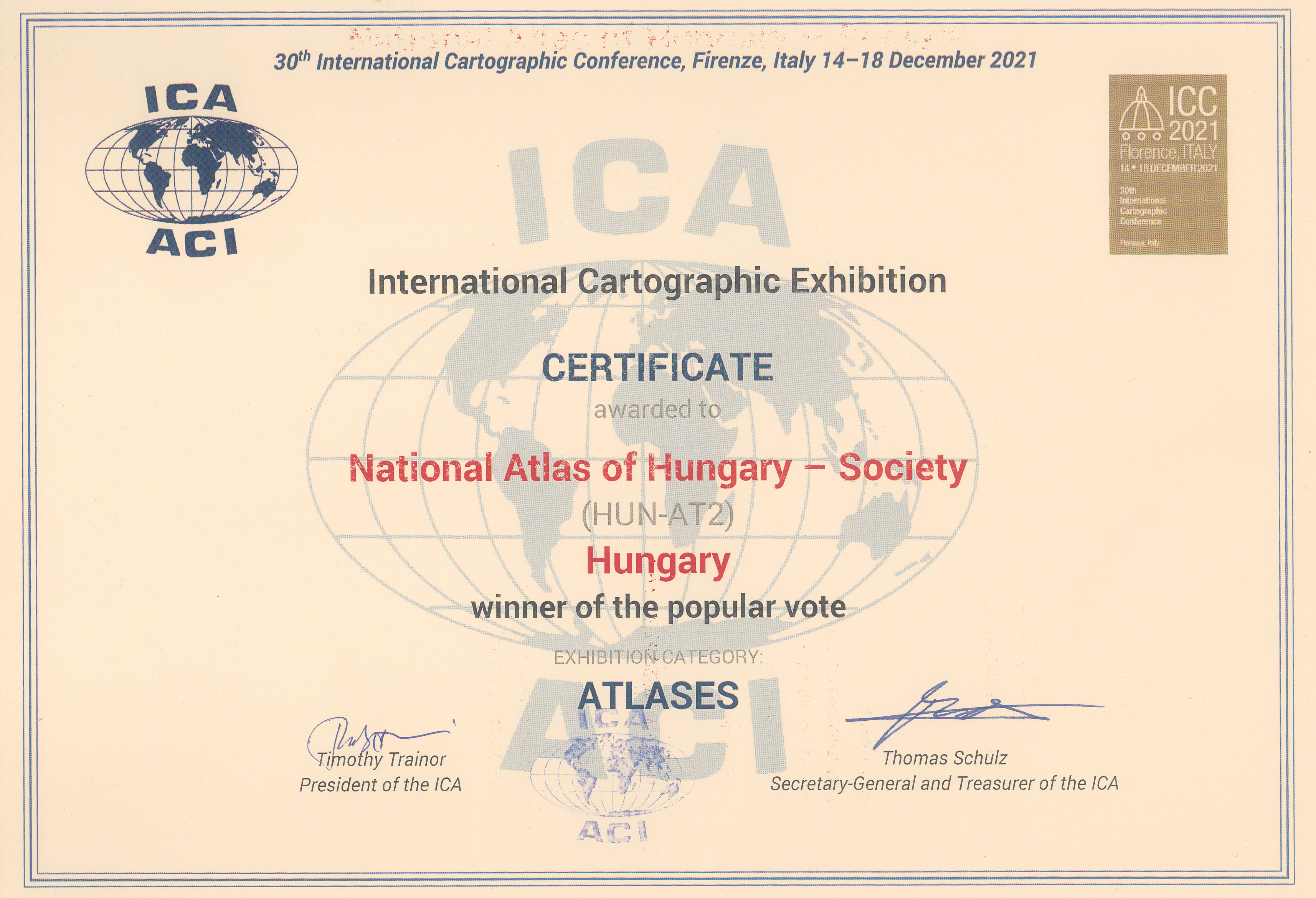
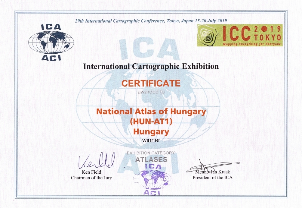
Dear @Super Dromaeosaurus:, please demonstrate and present that the disputed map, as well as the academic source that prepared and published it, is disputed and cannot be used on Wikipedia. If there are any, present the reviews published in scientific journals that say this is a "pseudoscientific" work. If there are none, then we are faced with the classic WP:JUST case. OrionNimrod has adequately rephrased the caption, making it clear that we are facing the Hungarian scientific position here. I would not have seen that you would have been similarly sensitive to the principle of "neutral point of view" in the articles List of Romanian words of possible pre-Roman origin and Vlachs, which contain a lot of nonsense. The map should not be deleted here, but expanded with information, and the results and positions of Romanian, Serbian, etc. scientific research should be published alongside the Hungarian one. --Norden1990 (talk) 18:54, 7 April 2025 (UTC)
- I am not a frequent editor of those two articles you mentioned, I'd be surprised if I had ever edited the list other than for correcting diacritics. If you see any nonsense in any of those, by all means, remove it.
- Let's establish a premise first: the 1495 village-to-village ethnic map falls under WP:EXCEPTIONAL. The map was produced a decade ago, seeminly giving a clear solution to an intense dispute between two national academias. But not only has it failed to attract the attention of third-party observer authors, it hasn't even received attention from Romanian academia. And I ask, how many times have you seen village-to-village ethnic maps from anytime before two centuries ago? Producing extremely speculative maps like this one is not a common practice in historiography. If we can agree that a 1495 village-to-village ethnic map is an exceptional claim, I would now argue the burden falls on those defending the map's reliability, can secondary reliable sources discussing and approving the map's unorthodox claims be provided? If we can not agree that the map makes exceptional claims, I recommend reading WP:EXCEPTIONAL again and start looking for those secondary sources.
- By the way, we are not discussing the
Hungarian scientific position
here. The mainstream Hungarian position is the immigrationist theory. It is not that X village had X% percentage of X ethnic group in X year centuries ago, this is pseudohistorical. And the solution is not providing equally ridiculous maps supporting different national POVs. Super Ψ Dro 19:54, 7 April 2025 (UTC)- Hell, the maps for 1495 and 1910 even use the same municipal borders ! How is this not ridiculous? Why do all urban centers have the same borders in 1495, when many cities were restricted by walls, and in 1910, when they were expanding and incorporating surrounding settlements? Super Ψ Dro 20:16, 7 April 2025 (UTC)
- Hi Super, I read wp:exceptional: this again talks about degrading unprofessional things: "fringe theories" "not mainstream sources" "self published sources" "need high quality sources", as demonstrated the map was published and republished many mainstream and top quality sources by many top academic institutions, universities (please do not ignore that the atlas got international award where this map was also republished, they international academic community di not find atlas/maps as "nonsense" "ridiculous" "pseudohistorical"). The map used in every Hungarian atlases, not just in the National Atlas (I linked just another 3 random academic books made by different scholars where the map was republished, those are also used as Hungarian schoolbooks). Which proves this is the mainstream academic historiography in Hungary about Hungary. This is 3rd revised edition, as the work started in 1990s, and many other earlier Hungarian atlas has the similar things regarding the Ottoman times, settlement destruction areas, migration movements, Germans, Slovaks, Croatians, etc settled many areas as you can see in the map 1784, which is not the dark ages. Please tell me why would be strange the knowledge which based on research that Szarvas in the center of Grand Hungarian Plain had Slovak majority in 1784 or Sibiu had German majority in 1495? For example you created Sopronbánfalva article claiming that was a German majority settlement in past, and according the Hungarian maps 1495, 1784, it was also German majority in that time. What is the exceptional fringe pseudohistorical knowledge with that? Scholars used many tax documents and sources.
- Why would Hungarian historiography insult anyone? It is not a secret that different countries has different historiography in certain subject everywhere in the world. Btw the map is not show theories, it clearly attributed that is settlement research/estimation by certain methods by Hungarian academic representing the mainstream Hungarian historiography. Following your logic, could we remove all Daco-Roman theory things, because its insults the neighboring countries? (As it is universally refused by Hungarian historiography, and not accepted in many other countries) Following your logic, could we remove any Romanian sources if no Hungarian opinions about that source? I do not think so. We need just present mainstream academic sources. Should we remove all population estimations from every articles, that X historian say population of Roman empire in 200 was X and another historian say different? I also see almost all Hungarian and Romanian articles (even almost in all individual settlement articles) population estimations by different scholars with very different results. Or do you think for example only estimations of Romanian Pop Aurel has right to publish in Wikipedia but not allowed to publish the mainstream Hungarian scholarschip estimation about Hungary? The Hungarian scholarship estimation is just one among them.
- Changing the ethnic pattern of Hungary because of Ottoman and Habsburg wars is a very important topic in Hungarian historiography. For example it is also important research for the Hungarian Germans, like the above linked impartial German user in German Wiki clearly said the map is correct when checked questioned details, also claimed that is not Hungarian POV as they used many foreign sources (many Slovak and Romanian sources too). I can see differences (not everywhere) in municipal borders in 1495, 1784, 1910 maps, there are also a lot of accompanying text regarding the map and methods.
- You do not need agree with the map (like Hungarian users do not accept many Romanian historiography), I do not understand why some users want to censor and hide it, because it is fact that is the mainstream Hungarian historiography about Hungary which is exist, and it is clearly attributed, so everybody know that is not a Romanian estimation. Nobody talked about censuses, we all know that is not census, and it is clearly attributed that is an "estimation", so nobody claim that is 100% fact/precision. I also added more attribution from the source, that emphasizing that is an estimated absolute/relative majority in the regions. The map presented in relevant articles, like ethnic changes during the long Ottoman war times, when Hungarian population and settlements highly suffered. OrionNimrod (talk) 20:33, 7 April 2025 (UTC)
- @OrionNimrod again, that German user failed then to adress ANY of the claims about villages with the name Olah in it in documents from the 15th century marked as Hungarian-majority in this map, or the fact that some towns like Deva or Hateg are marked as Hungarian-majority despite were seats of Romanian districts, and the discussion evolved only around the fact that Buda and Cluj were German or Hungarian-majority during that time, leading to nowhere as different historians cited claimed different things, as it is obvious to say we can't know exactly what ethnic group was the majority since there's no ethnic data from that time.
- This is literally the only ethnic map from before the 19th century in the entire Wikipedia that pretends to show with certainty the ethnic composition of each settlement from that time, having as proven before the bias to mark as Hungarian-majority as many settlements as possible, even settlements that didn't exist in 1495, so it's obvious that it is an extremely controversial material by itself, even without considering the debate between Hungarian and Romanian historians on the ethnic composition of the region during that time. ZZARZY223 (talk) 20:15, 11 April 2025 (UTC)
- ZZARZY223, All the sources I saw clearly state that Buda became a Hungarian majority in the 15th century, but after a lengthy discussion on many talk pages, I no longer have time to continue debating this. Probably, the German user would not even be able to prove the temperature on Mars, but there are academic scholars who have an opinion on this, and on Wikipedia, we present their viewpoints.
- "Certainty?" In the source, the authors clearly says " estimated absolute or relative linguistic majority", and I added this to the caption, do you understand the word "estimation"? But checking your Wiki activity, you have no problem cherry-picking estimations only what you like.
- Exactly which settlements did not exists in 1495 which are in this JPG map? I said many times that the interactive map background is a modern Google map for every date, just a background, but modern villages not named there if you click the areas. OrionNimrod (talk) 22:24, 11 April 2025 (UTC)
- @Super Dromaeosaurus Not only that asking for academic sources about why the maps are not fit for Wikipedia is unreasonable, also any sort of academic discussion about them is highly unlikely. All that the maps generated is an international scandal:
- https://english.sta.si/3378208/slovenia-points-to-existing-borders-in-face-of-hungary-nato-gifts
- Any self-respecting academic will avoid such "mainstream modern" works. Wikipedia should, too. Aristeus01 (talk) 21:49, 7 April 2025 (UTC)
- Aristeus01 as usual, your arguments just boring negative political things. What next? The authors has mustache and you do not like that so the map is not ok? (Even the published map in Wikipedia is not itself the National Atlas, the map was just republished there and in other books). The political scandal was not the maps, but that a Hungarian ambassador gifted the atlas, and they did not like to see depicting historical borders of Hungary. That is. The Natonal Atlas is a historical work as you saw already in the links, it was not clear? Did you realize it just now? Did you realize just now that the map is about the Carpathian Basin and not only the area of modern Hungary? And borders of Kingdom of Hungary is part of history. I really cannot do anything that some people do not like the Hungarian history and old borders of Kingdom of Hungary. An academic historical map would not be bad, because just some people are disturbed by the sight of the old Hungarian borders. :) What next? So you want also remove all maps from Wikipedia about Kingdom of Hungary, all international Europe history maps where Kingdom of Hungary presented in old borders, just because you cannot stand it, right? OrionNimrod (talk) 22:06, 7 April 2025 (UTC)
- dear @OrionNimrod calling officials of other countries "some people" is very inappropriate in this context. It would seem there is no limit to your depreciatory remarks towards other ethnicities, as the ones towards Romanians made earlier. Please, if you can find it in you, do not contact me again with these xenophobic comments. Aristeus01 (talk) 22:21, 7 April 2025 (UTC)
- @Aristeus01, All right, then I say: I cannot do anything if neighboring politicans were tiggered to see depicting historical borders of Hungary in a historical atlas which was gifted to them. Perhaps we could ban every history maps from Roman Empire because it can trigger the borders of today 30 countries? Ironically if I say "some people" it is xenophobic for you? In contrast you constantly degraded everything&everybody with vey bad accusations in this talk page and all efforts even political intrigues to disqualify Hungarian academic works. I wonder if you are as so critical of your cited Romanian sources as you are always critical very extremely vehemently against Hungarian sources? OrionNimrod (talk) 22:37, 7 April 2025 (UTC)
- @OrionNimrod You can not or do not want to? There is a difference. Calling state officials, including the President of Croatia, "some people" as if they are a random John on the street on a matter that concerns their nation, is, in your opinion, respectful towards them and their countries? Aristeus01 (talk) 22:49, 7 April 2025 (UTC)
- Aristeus01, sorry if I did not read carefully your link, but if you want so precise it was Croatian Foreign Minister and not Croatian President, but I do not interested political scandals. Sorry that I was not so polite and respectful as you when you accused International Cartographic Association as they are amateurs who using child labor just because they dared to award the Hungarian Atlas. I hope you are also respectful towards top academic Hungarian institutions and scholars. OrionNimrod (talk) 23:02, 7 April 2025 (UTC)
- @OrionNimrod You can not or do not want to? There is a difference. Calling state officials, including the President of Croatia, "some people" as if they are a random John on the street on a matter that concerns their nation, is, in your opinion, respectful towards them and their countries? Aristeus01 (talk) 22:49, 7 April 2025 (UTC)
- @Aristeus01, All right, then I say: I cannot do anything if neighboring politicans were tiggered to see depicting historical borders of Hungary in a historical atlas which was gifted to them. Perhaps we could ban every history maps from Roman Empire because it can trigger the borders of today 30 countries? Ironically if I say "some people" it is xenophobic for you? In contrast you constantly degraded everything&everybody with vey bad accusations in this talk page and all efforts even political intrigues to disqualify Hungarian academic works. I wonder if you are as so critical of your cited Romanian sources as you are always critical very extremely vehemently against Hungarian sources? OrionNimrod (talk) 22:37, 7 April 2025 (UTC)
- dear @OrionNimrod calling officials of other countries "some people" is very inappropriate in this context. It would seem there is no limit to your depreciatory remarks towards other ethnicities, as the ones towards Romanians made earlier. Please, if you can find it in you, do not contact me again with these xenophobic comments. Aristeus01 (talk) 22:21, 7 April 2025 (UTC)
- Aristeus01 as usual, your arguments just boring negative political things. What next? The authors has mustache and you do not like that so the map is not ok? (Even the published map in Wikipedia is not itself the National Atlas, the map was just republished there and in other books). The political scandal was not the maps, but that a Hungarian ambassador gifted the atlas, and they did not like to see depicting historical borders of Hungary. That is. The Natonal Atlas is a historical work as you saw already in the links, it was not clear? Did you realize it just now? Did you realize just now that the map is about the Carpathian Basin and not only the area of modern Hungary? And borders of Kingdom of Hungary is part of history. I really cannot do anything that some people do not like the Hungarian history and old borders of Kingdom of Hungary. An academic historical map would not be bad, because just some people are disturbed by the sight of the old Hungarian borders. :) What next? So you want also remove all maps from Wikipedia about Kingdom of Hungary, all international Europe history maps where Kingdom of Hungary presented in old borders, just because you cannot stand it, right? OrionNimrod (talk) 22:06, 7 April 2025 (UTC)
- Hell, the maps for 1495 and 1910 even use the same municipal borders ! How is this not ridiculous? Why do all urban centers have the same borders in 1495, when many cities were restricted by walls, and in 1910, when they were expanding and incorporating surrounding settlements? Super Ψ Dro 20:16, 7 April 2025 (UTC)
- @Norden1990 it's a fact that this is the only map that pretends to show the ethnic composition of any country/region from a time period before the 19th century in the entire Wikipedia, and this without considering the possible accuracy problems it has as discussed in the talk page of the map. For this reason the template that warns readers of the neutrality problems of the map should always remain if we choose to keep it in the article. ZZARZY223 (talk) 20:29, 11 April 2025 (UTC)
- Hi, as we can see ZZARZY223 pretends, that he "fights against non-neutral POV" + "no estimation, only census allowed" + "accuray problems" + "bias"
- On Romanian Wiki, ZZARZY223 removed a contemporary 1712 estimate made by the Austrian administrative authority, which stated that Romanians made up 34% of the population, likely because he did not like that number. In contrast, he replaced it with an estimate by Romanian historian Pop Aurel for the same year, claiming 65% Romanians. In this case, ZZARZY223 shows no concern about the fact that it is merely "an estimate", raises no issues about "accuracy", and does not question the lack of a proper "census". His scrutiny seems to apply only when top Hungarian academic institutions present Hungarian scholarship on the population history of Hungary.
- On Italian Wiki, ZZARZY223 reports that in Alba Iulia, between 1850 and 1910, the Romanian population increased from 2530 to 5170, while the Hungarian population grew from 1009 to 5226. He immediately labels this as "Magyarization", (even though the source only provides the numbers). In contrast, he removed any mention of "Romanianization" for the period between 1910 and 2002, during which the Romanian population rose from 5,170 to 56,016, while the Hungarian population declined from 5,226 to 1,767. In first timeline, Romanian population changed +2,640 and Hungarian +4,217 and ZZARZY223 labels this as "Magyarization", while in the next timeline Romnanian population +50,846 and Hungarian -3,459, in this case ZZARZY223 removed the "Romanianization", even the difference of numbers is huge. As we can see, ZZARZY223 exclusively presented personal Romanian POV perspective, even though here he pretends he fights for "neutral POV" and "bias".
- On Portugal Wiki, ZZARZY223 removed the fact that it is disputed whether the present-day Romanians are descendants of the Dacian-Roman population that remained after the 3rd century, or if the first Vlachs/Romanians arrived in the region in the 13th century, while he rewrote the text as fact that Romanization also occurred in other regions after the Romans. ZZARZY223 removed a contemporary estimate by Romanian voivode Vasile Lupu stating that 1/3 of the population were Romanians in 1650. In contrast, he added a claim that 60% of the population were Romanians in 1600, presenting it as fact without attributing it as an estimate. ZZARZY223 keeps adding only those sources that claim the number of Romanians exceeds the number of Hungarians. It appears that ZZARZY223 cherry-picks and only tolerates estimations he likes, and he wants to silence other mainstream academic theory which is not his preference.
- Absurdly, ZZARZY223 launched a campaign against a modern academic Hungarian map on Commons and German Wiki, even claiming that he knows the population history of the Hungarian capital better than Hungarian scholars themselves.
- ZZARZY223 says false things here, regarding what happened in German Wiki, a German user about his behavior: "What I don't like, to spread nonsense/fakes about the discussions in de:WP as ZZARZY223"
- It is not strange that population estimation based on sources and research shows, that for example, Szarvas in the center of Grand Hungarian Plain had Slovak majority in 1784 or Sibiu had German majority in 1495 as presented in the Hungarian academic map, even main articles claim that. Whether you like the map or not, that is Hungarian scholarship.
- I would be really curious if ZZARZY223 have the same vehement critics with old Romanian-made maps around 1900 "by census?" where vast uninhabited forests, mountains, and marshes, areas where maybe only 10 people lived, are carefully colored as Romanian, while large Hungarian-populated cities of 50,000 people are shown as little tiny dots, creating an obvious visual imbalance. Like this, which presented in articles whitout any attribution, but as a fact: https://en.wikipedia.org/wiki/File:Austro-Ungaria_si_Romania_(harta_etnica).jpg However, at that time, according to census, Cluj (with an 80% Hungarian population), and Oradea (with 90% Hungarian population) were marked as Romanian majority on that map, and no warning message: https://en.wikipedia.org/wiki/Cluj-Napoca#Demographics + https://en.wikipedia.org/wiki/Oradea#Demographics
- I rephrased the caption of the map with neutral language, making it clear that is not fact but an "estimation" but this is fact that this is "the Hungarian scientific position" about Hungary (by top academic institutions, in many academic books as above demonstrated). As we can see ZZARZY223 just wants to remove the Hungarian scholarship about Hungary/Hungarians which is not his prefence. He would like to use censorship against Hungarian scholarship. Of course, he doesn’t find any problem with adding the estimations he likes, and he happily removes all other viewpoints. His bad-faith editing is evident in his double standard, in his cross Wiki obsession with removing all views that are not to his preference. He can't be taken seriously.
- ZZARZY223 wants to attach a warning message only for Hungarian scholarship estimations, in order to stigmatize and discredit them immediately. OrionNimrod (talk) 22:09, 11 April 2025 (UTC)
- The map is not an estimation but aims to be very exact and comprehensive, and that X exact village was exactly X% of X ethnicity in 1495 is not "the Hungarian scientific position" but promoted exclusively through this biased map. You have mentioned several times the cases of Sibiu or Szarvas, when the least of problems are urban centers, for which it is obvious we have many sources, even though it is questionable that there are sources for the ethnic composition of all urban centers in Hungary exactly in 1495 rather than more generally in the 15th or 16th centuries. Super Ψ Dro 10:30, 12 April 2025 (UTC)
- The authors did not say exact X% by villages, I copied the attribution from the source to the caption: "estimated absolute or relative linguistic majority", to make it clear, it is an "estimation" based on their (30 year of) reserach. It is also properly attributed that is the Hungarian view. That is the modern academic Hungarian historiography about Hungary, as it published in many academic books. OrionNimrod (talk) 10:46, 12 April 2025 (UTC)
- Is it standard in Hungarian academia that exactly Mărtinești (next to Deva) was majority Hungarian exactly in 1495? I doubt you can cite any single source other than this map for this statement. Super Ψ Dro 11:19, 12 April 2025 (UTC)
- You can talk with the Hungarian academics who researched and created the map regarding very detailed questions (because the history of bigger settlements are more well known), I am also not able to prove the height of Mount Everest, but there are academic scholars who have an opinion on this, and on Wikipedia, we present their viewpoints. OrionNimrod (talk) 11:26, 12 April 2025 (UTC)
- Ah yes @Super Dromaeosaurus, you should ask the Hungarian academics for each one of the thousands of villages why are marked as Hungarian, Romanian or German-majority in the 1495 and 1784 map, they will surely respond :) It's definitely not up to the creators of this map to provide the data on which they based those maps.
- You can see in these sources (settlements A-N /// settlements O-Z) how many settlements appear with the name "Olah" in documents from the 15th century yet are marked as Hungarian-majority in the 1495 map (for example Bărăi, Cluj). ZZARZY223 (talk) 19:48, 17 April 2025 (UTC)
- Is it standard in Hungarian academia that exactly Mărtinești (next to Deva) was majority Hungarian exactly in 1495? I doubt you can cite any single source other than this map for this statement. Super Ψ Dro 11:19, 12 April 2025 (UTC)
- The authors did not say exact X% by villages, I copied the attribution from the source to the caption: "estimated absolute or relative linguistic majority", to make it clear, it is an "estimation" based on their (30 year of) reserach. It is also properly attributed that is the Hungarian view. That is the modern academic Hungarian historiography about Hungary, as it published in many academic books. OrionNimrod (talk) 10:46, 12 April 2025 (UTC)
- @OrionNimrod
- On the Romanian Wiki I removed that "census" because it was a cherrypicked source, it was presented alone without other points of view, and the fact that it is in contrasts with every single direct source from that time (early 18 century) and was choosen alone to be presented in that article was indeed problematic.
- On the Italian Wiki, I corrected the claim that the city of Alba Iulia was historically mostly ethnic Hungarian and then turned Romanian. It is in fact a result of Magyarization that the percentages of the ethnic Hungarians changed dramatically in the city (from 18,7% in 1850 to 45,0% in 1910 source). It was the absourd to claim the city was "Romanianized" as it was mostly Hungarian for only 20 years, while Romanians were the largest ethnic group for the rest of the time.
- I've already adressed the Portuguese Wiki edit here which you keep ignoring
- I didn't "absurdly launch a campaign" against this map, I simply noticed it has a lot of errors and it is biased to mark as Hungarian as many settlements as possible, for this reason i started the discussion on the talk page about its problems. Also what you fail to report is that the map was eventually removed from that article in German Wiki due to its problematic nature.
- Frankly, it is funny you lecture me about "bad faith" and that "I can't be taken seriously" when you even resort to cite as a source a clear anti-Romanian manifesto from a literal war criminal like Albert Wass.
- Like I've already replied before, the NPOV rule claims about undue weight that it "can be given in several ways, including but not limited to the depth of detail, the quantity of text, prominence of placement, the juxtaposition of statements, and the use of imagery." So if the map will is present in this article, it should also always have the template that warns readers of the neutrality problems.
- You keep comparing this map, literally the only one that presents the ethnic composition for each settlement during the Middle Ages in the entire Wikipedia, to actual ethnic maps from the 19th century and after (made by anthropologists and statisticians using actual data from that time) like those are similar at all in any regard. The map you linked has some minor errors but it is extremely similar with the ethnic maps from that time, like the 1855 map by Karl Freiherr von Czoernig for example. It looks like only the Hungarian historiography doesn't like this type of maps, despite they are used everywhere in Europe, so for years they resorted making some peculiar ethnic maps like the "Teleki's Red Map", an overexaggerated representation of ethnic Hungarians combined with arbitrarily density map (again, nowhere in Europe they used such a type of map), the István Kniezsa map about the ethnic composition in the 11th century (the only ethnic map made in the entire world using placenames, the vast majority of which don't even appear in documents before the 1200s!) and now this map that pretends to know the exact ethnic composition of thousands of villages that appear sporadically in documents from the 15th century. Also the Atlas website gives rough estimations of the number of ethnic group, as it claims "Two-thirds of them (2 to 2.1 million people) were probably Hungarians, one-third (1 to 1.1 million) non-Hungarian (ca. 340 thousand Slavonian-Croatians, 200 thousand Germans, 180 thousand Romanians, 170 thousand Slovaks, 100 thousand Serbs)", so how on earth can they even make an accurate ethnic map for each settlement with such rough estimations?
- So again, as long as this map is present in this article, it should always have the neutrality warning alongside it, due to its many, many problems I've already mentioned in the various discussions and given also the history of Hungarian academics and officials making such peculiar type of ethnic maps, which are not created or used anywhere in Europe outside of Hungary. ZZARZY223 (talk) 11:30, 12 April 2025 (UTC)
- ZZARZY223 Most of your "many many" made up problems have already been debunked, in Commons, in German Wiki (Like your claim that you know better the population of Hungarian capital than Hungarian scholars). The German user emphazied the map is good quality and not the quality is the reason of removal from that specific article, just because the map does not fit exactly to that article, that is (read his edit log), while the same experienced German Wiki user added the same map in relevant articles . Ethnic changes during Ottoman times in Hungary, Germans in Hungary, or demography of Hungary, etc... the map fits well as Hungarian scholarship about Hungarian population. It is also not true that Gyulafehervar/Alba Iulia (name: White city of Gyula) was Romanian "rest of the time outside 20 years", it was the capital of Hungarian chieftain Gyula, in 1495 map it shows Hungarian majority, and it was capital of Principality of Transylvania with Hungarian administration, nobles, but it marked as Romanian majority in map 1784, as population always changing. Good to know according to your personal Wikipedia:No original research (not in the source) Romanian population changed +2,640 and Hungarian +4,217 it is fact a "Magyarization", but when Romanian population with huge +50,846 and Hungarian -3,459 it is just "normal" and not "Romanianization": nice biased double standard view :) I do not remember exactly Albert Wass source, probably just I moved chapters (that sentence was just a tiny thing), but he is not considered a war criminal in Hungary Albert Wass#Statues but victim of Romanian nationalcommunist political games, USA authorities refused to extradite Wass to Romania claiming the lack of solid evidence, even Romanian dictator sent many times assassins after him, but Interpol and US police prevented those attempts, but he is out of topic. Do not compare 1855 with 1910, as you demonstrated that population of Alba Iulia how fast changed in every decades. The Teleki Red map is more accurate (in contrast some Romanian maps where even 90% Hungarian populated cities by census marked as Romanian city) as it not populate with people the uninhabited mountains, forests, marshes. Modern cartographers made a computer generated map based by 1910 census data (similar result as the Red map), here we can see population density, that cities have more people than forests. https://atlo.team/anyanyelviterkep/ All right, I see you really do not like the Hungarian estimations Wikipedia:I just don't like it, but it is still the very modern (not old) academic Hungarian historiography about Hungary, and Wikipedia based on reliable academic sources, you cannot censor the Hungarian scholarship about Hungary. In contrast, I see you are removing estimations from articles which is not your preference, and you are adding cherry-picking way only estimations to articles which is your preference without proper attribution or without any similar harsh critics. OrionNimrod (talk) 12:06, 12 April 2025 (UTC)
- @OrionNimrod You keep repeating the same claims over and over again, the discussion on that German Wiki article did not adress the issues regarding the settlements which bear the name "Olah" in documents from the 15 century (settlements A-N /// settlements O-Z) yet are marked as Hungarian-majority and the many settlements didn't even exist in 1495, yet are marked as Hungarian-majority as well. The discussion on German Wiki with WajWohu was almost only centered around wheter Cluj and Buda were Hungarian-majority in the year 1495. For the latter, there were provided sources from historians that did claim Hungarians were the majority in the city, but for Cluj it is still unclear wheter the Hungarian community was bigger than the German one in that year, like Balázs A. Szelényi's work I mentioned which claims that in the 15th century the city had a German majority.
- About Alba Iulia you claim It is also not true that Gyulafehervar/Alba Iulia (name: White city of Gyula) was Romanian "rest of the time outside 20 years", it was the capital of Hungarian chieftain Gyula, in 1495 map it shows Hungarian majority, and it was capital of Principality of Transylvania with Hungarian administration, nobles, but it marked as Romanian majority in map 1784, as population always changing. but again, no data exists from that time to assert as a fact the city was mostly Hungarian, just because it was the center of the Hungarian administration in Transylvania (also Gyula lived almost 5 centuries before this map is set in) doesn't mean the population of the settlement itself was mostly Hungarian, because like elsewhere in Europe the % of the population belonging to the ruling class was extremely small. I don't want to sound repetitive mentioning Buda again, but for similarity the city was the capital of Hungary, but until the late 14th century the vast majority of its inhabitants were German, even if it was the center of the Hungarian administration.
- With the "Magyariazation" and "Romanianization" discussion, like I said before, what's the point of saying a settlement was Romanianized if it was already Romanian-majority before? The population of the city massively grew under communist industrialization and most of those moving were people from the Romanian-majority population of the country, while Hungarians, as for the actual data we have, except for 20 years, were a minority in the city. Would you say that Nyíregyháza was "Magyarized" as the Slovak population in 1880 was 1/3 of the population, yet in the communist era the vast majority of the people moving in were Hungarians, while the Slovak population disappeared? Of course not, as the city was Hungarian-majority already. It makes sense to say a settlement was Magyarized or Romanianized if there was a shift in which ethnic group eventually became the majority.
- With Albert Wass, the fact that the US did not extradict him to Romania it's not that much a great defense for him, since many confirmed actual war criminals moved to the US after ww2 and the US wouldn't have extradicted anybody to a communist country during the Cold War. Still, a Romanian tribunal declared him a war criminal with enough evidence to confirm this, and is still to this day regarded as such even if in Hungary they make statues to honor him.
- I made the 1855 map by Karl Freiherr von Czoernig example because of your comment about this Romanian map, which is extremely similar to the first one. And again, like it or not, everywhere in Europe ethnic maps were made considering all the land no matter the density (which was almost impossible to accurately determinate back then). The Teleki map is indeed a very unusual ethnic map for that time. It's not original research to notice the fact that Hungarian scholars have been making all sorts of atypical maps, including ethnic maps from the Middle Ages, created nowhere else outside of Hungary, and it looks like other users like Aristeus01 and Super Dromaeosaurus have noticed other problems with the map as well, thus there's no point in derailing the discussion towards the edits I made which you don't like from the main discussion which is about the maps present in this article, which are the only maps that pretend to show the ethnic distribution during the 15th and 18th century for any country in the entire Wikipedia. For all these reasons, readers of this article must be informed of the neutrality problems of these maps, for both the 1495 and the 1784 one. ZZARZY223 (talk) 19:42, 17 April 2025 (UTC)
- Hello ZZARZY223, you keep repeating the same "you know better than scholars, you know better what should be Wikipedia:No original research, and you do not believe this modern Hungarian academic map" but it does not matter, because this is the Hungarians historiography about Hungarian history, whether you like it or not.
- In German Wiki, it was many detailed discussions about many things. Which settlements did not exist in 1495 in this JPG map? We can see just some marked settlements, and it shows only patches. You mentined "Decebal", the interactive map mentions only Vetés which existed before 1200 and not Újtelep (Decebal) which established 1550 (új=new in Hungarian): https://cdn.imgpile.com/f/pAaSkNm_xl.jpg (the background is a modern Google map with today settlement size and names)
- Nice that you repeat your personal biased viewpoint, that if a Romanian population changed +2,640 and Hungarian +4,217 during 60 years! it is not normal but it is fact a "Hungarianization" (+1500 Hungarian people than Romanians during 60 years :D), but when Romanian population changed with huge +50,846 and Hungarian -3,459 it is just "normal" and not "Romanianization".:)
- It would be fair to admit your real reason against the Hungarian map, you dont like it just because it does not fit "always majority Romanians in Transylvania" ideology, as this is a nationalist Romanian theory (which based on nationalist speculations not by historical sources). It is well known that Hungarian historiography (and many other neigboaring countries) does not accept the Daco-Roman theory, so you would like hide this or stigmatize this thing. I see you are removing estimations from articles by bad faith which is not your preference, while to the same articles you are adding cherry-picking way only estimations to articles which is your preference even without proper attribution but as fact. OrionNimrod (talk) 19:14, 23 April 2025 (UTC)
- ZZARZY223 Most of your "many many" made up problems have already been debunked, in Commons, in German Wiki (Like your claim that you know better the population of Hungarian capital than Hungarian scholars). The German user emphazied the map is good quality and not the quality is the reason of removal from that specific article, just because the map does not fit exactly to that article, that is (read his edit log), while the same experienced German Wiki user added the same map in relevant articles . Ethnic changes during Ottoman times in Hungary, Germans in Hungary, or demography of Hungary, etc... the map fits well as Hungarian scholarship about Hungarian population. It is also not true that Gyulafehervar/Alba Iulia (name: White city of Gyula) was Romanian "rest of the time outside 20 years", it was the capital of Hungarian chieftain Gyula, in 1495 map it shows Hungarian majority, and it was capital of Principality of Transylvania with Hungarian administration, nobles, but it marked as Romanian majority in map 1784, as population always changing. Good to know according to your personal Wikipedia:No original research (not in the source) Romanian population changed +2,640 and Hungarian +4,217 it is fact a "Magyarization", but when Romanian population with huge +50,846 and Hungarian -3,459 it is just "normal" and not "Romanianization": nice biased double standard view :) I do not remember exactly Albert Wass source, probably just I moved chapters (that sentence was just a tiny thing), but he is not considered a war criminal in Hungary Albert Wass#Statues but victim of Romanian nationalcommunist political games, USA authorities refused to extradite Wass to Romania claiming the lack of solid evidence, even Romanian dictator sent many times assassins after him, but Interpol and US police prevented those attempts, but he is out of topic. Do not compare 1855 with 1910, as you demonstrated that population of Alba Iulia how fast changed in every decades. The Teleki Red map is more accurate (in contrast some Romanian maps where even 90% Hungarian populated cities by census marked as Romanian city) as it not populate with people the uninhabited mountains, forests, marshes. Modern cartographers made a computer generated map based by 1910 census data (similar result as the Red map), here we can see population density, that cities have more people than forests. https://atlo.team/anyanyelviterkep/ All right, I see you really do not like the Hungarian estimations Wikipedia:I just don't like it, but it is still the very modern (not old) academic Hungarian historiography about Hungary, and Wikipedia based on reliable academic sources, you cannot censor the Hungarian scholarship about Hungary. In contrast, I see you are removing estimations from articles which is not your preference, and you are adding cherry-picking way only estimations to articles which is your preference without proper attribution or without any similar harsh critics. OrionNimrod (talk) 12:06, 12 April 2025 (UTC)
- The map is not an estimation but aims to be very exact and comprehensive, and that X exact village was exactly X% of X ethnicity in 1495 is not "the Hungarian scientific position" but promoted exclusively through this biased map. You have mentioned several times the cases of Sibiu or Szarvas, when the least of problems are urban centers, for which it is obvious we have many sources, even though it is questionable that there are sources for the ethnic composition of all urban centers in Hungary exactly in 1495 rather than more generally in the 15th or 16th centuries. Super Ψ Dro 10:30, 12 April 2025 (UTC)
- Hi, as we can see ZZARZY223 pretends, that he "fights against non-neutral POV" + "no estimation, only census allowed" + "accuray problems" + "bias"
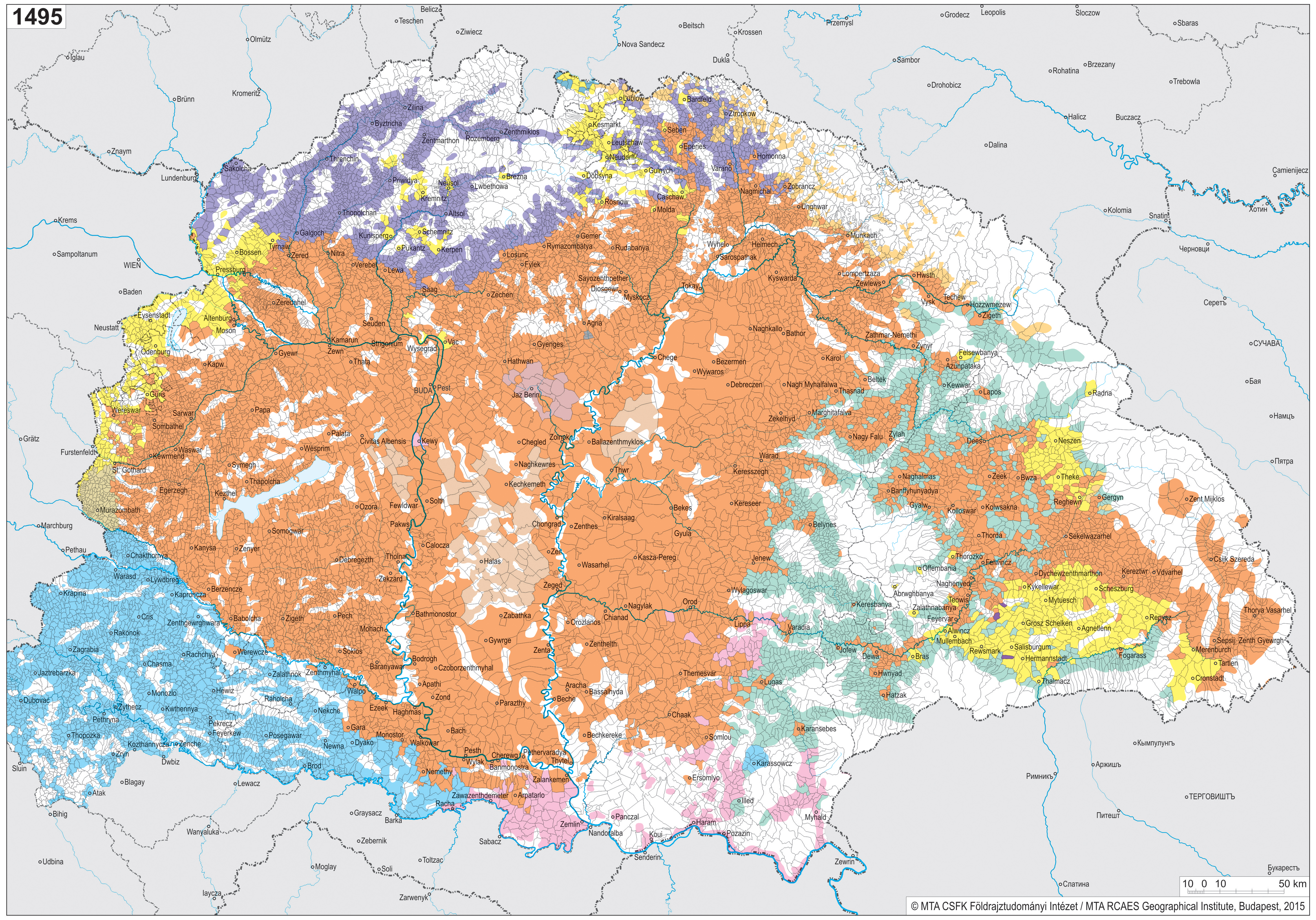
.jpg)
References
- ↑ Cantat, Céline; Dönmez, Pınar E. (2021). "Authoritarian and neoliberal attacks on higher education in Hungary". Radical Philosophy (210): 55–64. ISSN 0300-211X.
- ↑ "Hungary's Attack on Academic Freedom". www.hks.harvard.edu. 2020-03-29. Retrieved 2025-04-06.
- ↑ Halmai, Gábor; Ryder, Andrew (2025). "How the destroyers of academic freedom masquerade themselves as its victims". cadmus.eui.eu. doi:10.59704/3e987182a4cc404a. ISSN 2366-7044.