Yên Hòa [iən˧˧:hwa̤ː˨˩] is a ward[3][4] of Hanoi the capital city in the Red River Delta of Vietnam.
Yên Hòa Ward
Phường Yên Hòa Xã Yên Hòa | |
|---|---|
From top, left to right : Trung Kính Hạ Temple at Trung Kính Street, Trung Yên 1 Apartment and Yên Hòa Parkview City at Vũ Phạm Hàm Street, Charm-Vit Tower and Thăng Long BigC Supercenter at Trần Duy Hưng Street. | |
| Nickname: "Làng Giàn" (Giàn Village) | |
 Interactive map of Yên Hòa Ward | |
| Country | |
| Region | Red River Delta |
| Municipality | Hà Nội |
| Establishment | 1949 (commune) September 1, 1997[note 1] (ward) |
| Central hall | No.231, Nguyễn Ngọc Vũ Street, Yên Hòa Ward |
| Government | |
| • Type | Ward-level authority |
| • People Committee's Chairman | Trịnh Thị Dung |
| • People Council's Chairman | Nguyễn Quốc Khánh |
| • Front Committee's Chairman | Trần Cẩm Anh |
| • Party Committee's Secretary | Nguyễn Quốc Khánh |
| Area | |
• Total | 4.10 km2 (1.58 sq mi) |
| Population (July 1, 2025)[2] | |
• Total | 77,029 |
| • Density | 18,800/km2 (48,700/sq mi) |
| • Ethnicities | Kinh Tanka Others |
| Time zone | UTC+7 (Indochina Time) |
| ZIP code | 10000–11312[note 2] |
| Climate | Cwa |
| Website | Yenhoa.Hanoi.gov.vn Yenhoa.Hanoi.dcs.vn |

.JPG)

History
editIts name Yên Hòa (Hán: 安和, Nôm: 𭴣和) is originally a combination of seven localities that have many cultural traditions in urban Hanoi : Hòa Mục (or Nhân Hòa), Trung Hòa (or Trung Kính Thượng),[5] Trung Kính (or Đàn Kính Chủ), Trung Yên (or Trung Kính Hạ), Yên Hòa, Yên Lãng, and especially Yên Quyết (or Bạch Liên Hoa).[6]
The modern area of Yên Hòa Ward is two former administrative units with a very long history : Kẻ Cót Village (Hạ Yên Quyết Village) and Kẻ Giàn Village (Đàn Kính Chủ Village). Their remaining relics is an old communal hall called Trung Kính Hạ.[7]
Middle Ages
editAccording to Đồng Khánh địa dư chí lược (同慶地輿志略), around the late years of Gia Long, the Southwestern area of Hà Nội Citadel still belonged to Từ Liêm rural district, Quốc Oai prefecture, Sơn Tây garrisons of the Northern Citadel region[note 3].
By 1831, Emperor Minh Mệnh issued an Order[note 4] to eliminate the Ming-style "garrisons" regime to switch to the Qing-style "province" regime. Since then, Từ Liêm district has been part of Hoài Đức prefecture of Hà Nội province. In particular, the area of this district-level administrative unit consisted of 5 villages from its North to South and West to East side : Yên Quyết (Kẻ Cót), Dịch Vọng (Kẻ Vòng), Mễ Trì (Kẻ Mẩy), Yên Lãng (Kẻ Láng), Đàn Kính Chủ (Kẻ Giàn). These administrative systems and names have remained the same until the end of the 1950s by many different governments.
20th century
editIn 1961, in the process of expanding the area of urban Hà Nội in the Southwest direction, most of those villages were merged into two urban districts V and VI, while Mễ Trì village became the commune of Từ Liêm rural district. Four merged villages have been raised to townships. Because at that time in the North Vietnam, there was no ward-level yet.
On November 22, 1996, the Government of Vietnam issued Decree 74-CP to establish Cầu Giấy urban district on the basis of the entire area and population of 4 former townships Cầu Giấy, Mai Dịch, Nghĩa Đô, Nghĩa Tân, and 3 communes Dịch Vọng, Trung Hòa, Yên Hòa, belonging to Từ Liêm district. In particular, Cầu Giấy township was renamed to Quan Hoa ward. When newly established, the district had 7 wards : Dịch Vọng, Mai Dịch, Nghĩa Đô, Nghĩa Tân, Quan Hoa, Trung Hòa, and Yên Hòa.
21st century
editOn April 19, 2025, to realize the project to arrange and merge administrative units by the Government of Vietnam, the Hà Nội People's Committee quickly approved a Resolution on the plan of re-arranging commune+ward-level administrative units in the whole city.[8]
According to the political document published for the press in the same day, Cầu Giấy Urban District was officially dissolved. Its entire area and population have been divided into three new wards Cầu Giấy 1 (Cầu Giấy), Cầu Giấy 2 (Nghĩa Đô), and Cầu Giấy 3 (Yên Hòa).[9] From that reality, Yên Hòa Ward[10] (安和坊, phường Yên Hòa) has been established based on the merging of :
- The entire natural area and population of two former wards Trung Hòa and Yên Hòa.
- The part of two former ward Mễ Trì (Nam Từ Liêm District) and Nhân Chính (Thanh Xuân District).
This has helped to double the size of the new administrative unit. Yên Hòa Ward is under the direct management of the Hà Nội City People's Committee.
Geography
editTopography
editYên Hòa Ward situates roughly to the Southwest area of urban Hanoi. According to the content of the planning map, what was given to households on 17 April 2025,[11] the administrative unit called Cầu Giấy 3 or New Yên Hòa Ward is located in the South of Cầu Giấy Ward through Dương Đình Nghệ Street and the North of Thanh Xuân Ward through Lê Văn Lương Street. Its West is Từ Liêm Ward and a little of Đại Mỗ Ward, while its East is adjacent to the Tô Lịch River and connected to the other side of the 361 Bridge by Láng Ward.
Before 2013, 2/3 of the area of Yên Hòa Ward was still vegetable fields. However, since the Trần Duy Hưng Street has been completed and put into commercial exploitation, it has divided this ward into two little zones in Hanoi.
 Dương Đình Nghệ Street along the Northern side of the ward
 Phạm Hùng Street along the Western side of the ward
 361 Bridge from Láng Boulevard to Vũ Phạm Hàm Street
 Tô Lịch Riverside Parks[note 5] along the banks of Tô Lịch River
 Láng Boulevard along the Eastern side of the ward
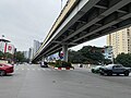 Lê Văn Lương Street along the Southern side of the ward


Natural space
edit Tinh Hoa Pond
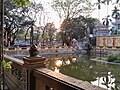 Nguyệt Hà Pond
 Round Quarter, YHPV
 Rosy Quarter, YHPV
 Golden Garden, YHPV
 Híkaros Gardens
 Tô Lịch Riverside Parks
 Trung Kính Hạ Playground
 Học Phi Street
 Xuân Quỳnh Street


Climate
editLike Hanoi, under the Köppen climate classification Yên Hòa Ward has a humid subtropical climate (Cfa).[12] There is significant air pollution in Yên Hòa like other wards of Hanoi. A 2022 study from the Vietnam National University determined that most of the air pollution in here is caused by particulates. Nitrogen oxides, carbon monoxide and sulfur dioxide in the air are also present in significant amount.[13]
| Climate data for Yên Hòa Ward | |||||||||||||
|---|---|---|---|---|---|---|---|---|---|---|---|---|---|
| Month | Jan | Feb | Mar | Apr | May | Jun | Jul | Aug | Sep | Oct | Nov | Dec | Year |
| Record high °C (°F) | 33.3 (91.9) |
35.1 (95.2) |
37.2 (99.0) |
41.5 (106.7) |
42.8 (109.0) |
41.8 (107.2) |
40.8 (105.4) |
39.7 (103.5) |
37.4 (99.3) |
36.6 (97.9) |
36.0 (96.8) |
31.9 (89.4) |
42.8 (109.0) |
| Mean daily maximum °C (°F) | 19.8 (67.6) |
20.6 (69.1) |
23.2 (73.8) |
27.7 (81.9) |
31.9 (89.4) |
33.4 (92.1) |
33.4 (92.1) |
32.6 (90.7) |
31.5 (88.7) |
29.2 (84.6) |
25.7 (78.3) |
22.0 (71.6) |
27.6 (81.7) |
| Daily mean °C (°F) | 16.6 (61.9) |
17.7 (63.9) |
20.3 (68.5) |
24.2 (75.6) |
27.6 (81.7) |
29.3 (84.7) |
29.4 (84.9) |
28.7 (83.7) |
27.7 (81.9) |
25.3 (77.5) |
21.9 (71.4) |
18.3 (64.9) |
23.9 (75.0) |
| Mean daily minimum °C (°F) | 14.5 (58.1) |
15.8 (60.4) |
18.4 (65.1) |
21.9 (71.4) |
24.8 (76.6) |
26.4 (79.5) |
26.5 (79.7) |
26.1 (79.0) |
25.2 (77.4) |
22.8 (73.0) |
19.3 (66.7) |
15.8 (60.4) |
21.5 (70.7) |
| Record low °C (°F) | 2.7 (36.9) |
5.0 (41.0) |
7.0 (44.6) |
9.8 (49.6) |
15.4 (59.7) |
20.0 (68.0) |
21.0 (69.8) |
20.9 (69.6) |
16.1 (61.0) |
12.4 (54.3) |
6.8 (44.2) |
5.1 (41.2) |
2.7 (36.9) |
| Average rainfall mm (inches) | 22.5 (0.89) |
24.6 (0.97) |
47.0 (1.85) |
91.8 (3.61) |
185.4 (7.30) |
253.3 (9.97) |
280.1 (11.03) |
309.4 (12.18) |
228.3 (8.99) |
140.7 (5.54) |
66.7 (2.63) |
20.2 (0.80) |
1,670.1 (65.75) |
| Average rainy days | 9.5 | 11.4 | 15.9 | 13.7 | 14.6 | 14.8 | 16.6 | 16.5 | 13.2 | 9.7 | 6.8 | 5.2 | 147.9 |
| Average relative humidity (%) | 79.9 | 82.5 | 84.5 | 84.7 | 81.1 | 80.0 | 80.7 | 82.7 | 81.0 | 78.5 | 77.1 | 76.2 | 80.7 |
| Mean monthly sunshine hours | 68.7 | 48.1 | 45.5 | 87.4 | 173.7 | 167.0 | 181.1 | 163.0 | 162.4 | 150.3 | 131.6 | 113.0 | 1,488.5 |
| Source 1: Vietnam Institute for Building Science and Technology[14] | |||||||||||||
| Source 2: Extremes[a] | |||||||||||||
Administration
editPublic administration
edit
- Local level
- Yên Hòa Ward People's Committee: No.231, Nguyễn Ngọc Vũ Street, Yên Hòa Ward of the urban Hanoi.
- Yên Hòa Ward Communist Party Committee and Fatherland Front Committee: No.255, Nguyễn Khang Street, Yên Hòa Ward of the urban Hanoi.
- Yên Hòa Ward Public Administrative Service Center: No.231, Nguyễn Ngọc Vũ Street, Yên Hòa Ward of the urban Hanoi.[20]
- Yên Hòa Ward Police Station: No.73, Đỗ Quang Street, Yên Hòa Ward of the urban Hanoi.
- Central level
- Supreme People's Procuracy: No.9, Phạm Văn Bạch Street, Yên Hòa Ward of the urban Hanoi.
- Government Inspectorate: No.20, Hoàng Quán Chi Street, Yên Hòa Ward of the urban Hanoi.
- State Audit Office: No.116, phố Nguyễn Chánh Street, Yên Hòa Ward of the urban Hanoi.
- Telecommunications Department: No.68, Dương Đình Nghệ Street, Yên Hòa Ward of the urban Hanoi.
- Hanoi Land Development Center: No.46, Lưu Quang Vũ Street, Yên Hòa Ward of the urban Hanoi.
- Institute of Agricultural Mechanization and Post-Harvest Technology: No.60, Trung Kính Street, Yên Hòa Ward of the urban Hanoi.
Traffic routes
editAccording to the roadmap to be implemented from July 1, 2025, in addition to the streets that existed before the reform and merger, six projects, essentially new urban areas Cầu Giấy, Dịch Vọng, Nam Trung Yên, Trung Hòa Nhân Chính, Trung Yên, and Yên Hòa, will begin to be divided into streets with completely new names.[21] These new names are inspired by the names of famous writers and journalists,[22] aiming to create a distinctive character for the administrative units they belong to.[23]
| Name | Function | Date of plaque unveiling | Length (km) | Describe |
|---|---|---|---|---|
| Đinh Núp | Street | December 4, 2019[24] | 1 | Previously part of Nam Trung Yên resettlement area. |
| Đỗ Quang | Street | 2010 | 0,3 | Previously it was Alley 61 of Trần Duy Hưng Street. |
| Dương Đình Nghệ | Street | ? | 0,71 | Previously part of Cầu Giấy Urban District. |
| Hạ Yên Quyết | Street | January 16, 2021[25] | 0,4 | From former Yên Hòa Street and part of Trung Kính Street. |
| Hoa Bằng | Street | July, 1999 | 0,55 | Previously part of Yên Hòa urban area. |
| Hoàng Đạo Thúy | Street | August 2005[26] | 1,1 | From Trung Hòa Nhân Chính urban area. |
| Hoàng Minh Giám | Street | August 2005[27] | 1,128 | Previously part of Trung Hòa Nhân Chính urban area. |
| Hoàng Ngân | Street | December 2006[28] | 1,25 | Previously part of Trung Kính Thượng Village. |
| Hoàng Quán Chi | Street | October 6, 2022[29] | 1,180 | Previously part of Cầu Giấy urban area. |
| Học Phi | Street | August 29, 2025[30] | 0,4 | From Trung Yên 8 Road. |
| Khuất Duy Tiến | Boulevard | 2001 | 1,7 | Previously part of Từ Liêm Urban District. |
| Láng | Boulevard | 1986[31][32] | 0,54 | From Láng Road and Tô Lịch Riverside Road. |
| Lê Văn Lương | Street | 2000 | 3,5 | From Cầu Giấy Urban District. |
| Lưu Quang Vũ | Street | December 10, 2021[33][34] | 0,43 | Previously it was Trung Yên 3 Road. |
| Mạc Thái Tổ | Street | July 6, 2015[35] | 0,9 | From Trung Kính Street. |
| Mạc Thái Tông | Street | October 18, 2015[36] | 0,84 | From Trung Kính Street. |
| Nam Trung Yên | Street[s] | ? | ? | Consists of unnamed routes from Nam Trung Yên resettlement area. |
| Nguyễn Bá Khoản | Street | March 12, 2022[34] | 0,47 | Previously it was Trung Yên 9 Road. |
| Nguyễn Chánh | Street | December 10, 2021[37] | 1 | Previously part of Trung Kính Street. |
| Nguyễn Khang | Street | ? | 2,1 | From Cầu Giấy Urban District. |
| Nguyễn Ngọc Vũ | Street | July, 2000[38] | 1 | From Trung Kính Thượng Village. |
| Nguyễn Như Uyên | Street | March 12, 2022[34] | 0,73 | From Nam Trung Yên resettlement area. |
| Nguyễn Quốc Trị | Street | January 26, 2019[39] | 0,12 | From Nam Trung Yên resettlement area. |
| Nguyễn Thị Duệ | Street | January 16, 2021[25] | 0,791 | Previously it was Alley 219 of Trung Kính Street. |
| Nguyễn Thị Định | Street | December, 2006 | 0,1 | Previously part of Trần Duy Hưng Street. |
| Nguyễn Thị Thập | Street | December, 2006 | 0,8 | From Trần Duy Hưng Street. |
| Nguyễn Vĩnh Bảo | Street | October 6, 2022[29] | 0,57 | Previously part of Trung Yên urban area. |
| Nguyễn Xuân Linh | Street | January 11, 2020[24][40] | 0,5 | From Trung Hòa Nhân Chính urban area. |
| Nguyễn Xuân Nham | Street | January 19, 2024[41] | 0,65 | From Nam Trung Yên resettlement area. |
| Nhân Hòa | Street | January, 1999 | 0,45 | From two villages Quan Nhân and Hòa Mục. |
| Phạm Hùng | Street | January, 2002[42] | 4,1 | Previously part of Dịch Vọng urban area. |
| Phạm Văn Bạch | Street | August 11, 2015[43] | 0,5 | From Cầu Giấy urban area. |
| Thâm Tâm | Street | January 19, 2024[44] | 0,595 | Previously it was Trung Yên 6 Road. |
| Thượng Yên Quyết | Street | January 27, 2026[45][46] | 0,215 | Previously it was Alley 381 of Nguyễn Khang Street. |
| Trần Duy Hưng | Street | 1999 | 2,5 | From Trung Kính Thượng Village. |
| Trần Kim Xuyến | Street | March 5, 2014[47] | 0,55 | From Yên Hòa urban area. |
| Trần Thái Tông | Street | 2008[48] | 0,5 | Previously part of Nguyễn Phong Sắc Street. |
| Trung Hòa | Street | ? | 1,2 | From small parts of former streets Trung Yên and Yên Hòa. |
| Trung Kính | Street | ? | 1,9 | Previously part of Trung Kính Hạ Village. |
| Trung Yên | Street[s] | ? | ? | Consists of unnamed routes from Trung Yên urban area. |
| Tú Mỡ | Street | January 26, 2019[39][49] | 0,9 | Previously it was the dike road of Trung Kính Street. |
| Vũ Phạm Hàm | Street | July 14, 2010 | 1,5 | Formerly known as Trung Yên 1 Road from Cầu Giấy Urban District. |
| Xuân Quỳnh | Street | December 10, 2021[33] | 0,47 | Previously it was Trung Yên 11 Road. |
Notes:
Culture
editYên Hòa Ward has long been dubbed one of the three core areas of tradition in capital city Hà Nội. This area still retains many historical sites,[50] and is also known as the birthplace of many notable persons and developed professions.[51]
Architecture
edit- Relics
According to old maps, during the period from 1873 to 1882, when conflict between French and Annamese forces was intense, the area that is now Yên Hòa Ward was originally the boundary between two provinces Hà Nội and Hà Đông. Its location in the southwest of the Hà Nội Citadel, where the Tô Lịch River and a dense swampy area are situated, has inadvertently helped it preserve a system of old relics.[49]
Following the official establishment of the ward-level administrative unit in 2025, the authority has compiled some statistics on the system of historical sites, which have existed since at least the 1980s and are associated with the period preceding the new ward. However, due to their sheer number, only three structures are considered representative based on their importance in local beliefs and the number of festivals associated with them in a year. In a more specific way : Trung Kính Thượng and Trung Kính Hạ Temples, where only one deity is worshipped, who received official respect from the Nguyễn Dynasty[52] ; Dục Anh Temple, where are associated with the Mother Goddess religion, were recognized by the Nguyễn Dynasty in 1889 and 1924, respectively, and were classified as "historical and architectural relics" by the Ministry of Culture and Information in 1992.[53]
Besides religious significance, Yên Hòa Ward has also been fertile ground for the development of knowledge and literature since the Lê Dynasty. This is evident not only in the number of scholars whose names are inscribed on stone steles at the Temple of Literature, but also in the names of many prominent figures who lived and died under all modern Vietnamese regimes. Some of these structures are still preserved intact today, including:
- House numbers from 1236 to 1248 at Láng Boulevard, with the semi-official name the Memorial Area of Poet Tú Mỡ.[note 6] A fully furnished house on a 1000m² plot of land, built in 1935 according to the design of architect Nguyễn Cao Luyện. The house adheres to the "house of light"[note 7] style of the Self-Reliant Literary Group, with all the bricks ordered from Bát Tràng village. This was one of the familiar addresses for scholars and artists in North Vietnam from its inauguration until Tú Mỡ's death.[54] In 2015, when the Hanoi City People's Committee simultaneously implemented two projects – the "Expansion of Cầu Giấy Intersection" and the "Elevated Railway Line" – the expansion of Láng Boulevard resulted in a loss of one-third of the land area. This drew public condemnation because the memorial site became dilapidated.[55] After most of the house's structure was demolished, what remained was renovated to become Café 1238. This address continues to be a meeting place for Hanoian writers.[56]
- Trung Kính Hạ Cultural House, where was constructed right at the beginning of the State of Vietnam regime, serving as the headquarters of the local police force. Over the years, its architecture has remained virtually unchanged. At times it served as a community cultural center, and at other times it was used for two functions: A fitness and gym center during the day, and the office of the civil defense force at night. The grounds of this historical site have long been used to preserve several very old stone steles from Trung Kính Hạ Village.
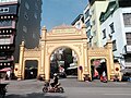 Gate of Dịch Vọng Hậu Village
 Gate of Trung Kính Hạ Village
 Old gate at Trung Kính Hạ Village
 Trung Kính Hạ Hall
 Trung Kính Hạ Patron Temple
 Old well of Trung Kính Hạ Village
 Mother Goddess Shrine
 Trần Khánh family shrine
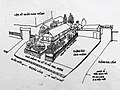 Poet Tú Mỡ's Memorial Area before demolition
 Diagram of Trung Kính Hạ Village 1970
 Diagram of Trung Kính Hạ Village 1970


- Modern sites


 Vimeco II Apartments
 Trung Yên Plaza
 Eurowindow Multi Complex
 Hồng Vận Hotel
 Coq d'Or Restaurant
 Trung Yên 1 Apartments
 Quốc Sỹ Apartments
 Mandarin Garden Apartments
 Yên Hòa Sunshine Apartments


.JPG)

Education
edit RoyalKidz Montessori Kindergarten
 Lý Thái Tổ Schools
 Hanoiamsterdam High School
 Hanoi Community College

 Archimedes Academy
 Point Avenue PTE[note 8]
 Peace School


.jpg)


Famous persons
edit- Pre-1986
- Composer Chung Quân
- Composer Doãn Nho
- Writer Doãn Quốc Sỹ
- Doctorate Đặng Công Toản
- Doctorate Đỗ Công Toản
- Doctorate Đỗ Văn Luân
- Doctorate Đỗ Văn Tổng
- Doctorate Hoàng Bôi
- Doctorate Minh Tuyền Hoàng Chí Trị
- Doctorate Hoàng Quán Chi
- Scholar Hoa Bằng Hoàng Thúc Trâm
- Scholar Hoàng Xuân Sính
- Doctorate Hoàng Viết Ái
- Journalist Học Phi
- Shaman Lê Đại Điên
- Reciter Linh Nhâm
- Doctorate Nguyễn Công Thước
- Doctorate Nguyễn Danh Hiền
- Doctorate Nguyễn Dụng Nghệ
- Doctorate Nguyễn Dụng Triêm
- First doctoral candidate Nguyễn Hiền
- Doctorate Nguyễn Huy
- Writer Nguyễn Huy Tưởng
- Doctorate Nguyễn Khiêm Quang
- Doctorate Nguyễn Như Uyên
- Doctor degree Nguyễn Quang Minh (Nguyễn Nhữ Minh)
- Doctorate Nguyễn Sần
- Doctorate Nguyễn Xuân Nham
- Doctorate Nguyễn Viết Tráng (Nguyễn Nhật Tráng)
- Doctorate Nguyễn Vĩnh Thịnh
- Poet Thanh Tâm Tuyền
- Writer Trung Trung Đỉnh
- Poet Tú Mỡ
- Zen master Từ Đạo Hạnh
- Modern
- Fimmaker Bùi Chí Trung
- Footballer Đỗ Hùng Dũng
- Actress Hoàng Hà
- Shooter Hoàng Xuân Vinh
- Actress Hoàng Yến Chibi
- Actor Lê Bá Anh
- Actress Trần Thị Minh Hòa
- Actress Nguyễn Ngọc Thư
- Lawyer Nguyễn Danh Huế
- Painter Nguyễn Đại Thắng
- Actor Nguyễn Đình Khang
- Actor Phạm Minh Tuấn
- MC & content editor Nguyễn Quốc Khánh
- Female model Nguyễn Quỳnh Anh
- Actress Quỳnh Kool
- Singer Soobin Hoàng Sơn
See also
editNotes and references
editNotes
edit- ↑ Phường Yên Hòa chính thức đi vào hoạt động từ ngày 1/9/1997 theo Nghị Định 74/CP ngày 22/11/1996 của Chính Phủ trên cơ sở là xã Yên Hòa, huyện Từ Liêm (cũ).
- ↑ An official code from December 31, 2022, to present.
- ↑ Bắc Thành.
- ↑ Đạo dụ.
- ↑ This system is made up of 4 smaller parks.
- ↑ Khu lưu niệm Thi Sĩ Tú Mỡ.
- ↑ Nhà ánh sáng.
- ↑ It was founded in Hanoi 2018 by a group of West Point graduates but exists independently of that organization.
References
edit- ↑ "Niên giám thống kê năm 2018". Archived from the original on 2021-06-03. Retrieved 2021-02-21.
- ↑ General Statistics Office of Vietnam (2019). "Completed Results of the 2019 Viêt-Nam Population and Housing Census" (PDF). Statistical Publishing House, Hanoi. ISBN 978-604-75-1532-5.
- ↑ Hà Nội "chốt" phương án sắp xếp và tên gọi 126 xã–phường mới
- ↑ Phường Yên Hòa sáp nhập từ những phường nào của TP Hà Nội ?
- ↑ Trung Hòa - vùng đất văn hiến xưa
- ↑ Hiển vinh năm họ Bạch Liên Hoa
- ↑ Lễ hội đình làng Trung Kính Hạ : Gìn giữ và phát huy những giá trị văn hóa truyền thống trong lòng Thủ Đô
- ↑ Yên Hòa Ward People's Committee – Resolution No.04/PA-UBND (pdf)
- ↑ Quận Cầu Giấy dự kiến còn ba phường sau sắp xếp
- ↑ Phường Yên Hòa : Những thông tin chi tiết sau sắp xếp
- ↑ Thông tin chi tiết về dự kiến ba phường của quận Cầu Giấy sau sắp xếp
- ↑ "Climate Hanoi : Temperature, Climate Graph, Climate Table for Hanoi". Climate-Data.org. Retrieved 2023-12-07.
- ↑ Dương, Phạm Bình; Hà, Phạm Thị Thu (2022-11-22). "Đánh giá chất lượng không khí trên địa bàn Cầu Giấy". TNU Journal of Science and Technology. 227 (16): 165–173. doi:10.34238/tnu-jst.6538. ISSN 2615-9562.
- ↑ "Vietnam Institute for Building Science and Technology" (PDF).
- ↑ "Hà Nội nóng kỷ lục 41.5 độ". DanViet.vn (in Vietnamese). Archived from the original on 3 June 2017. Retrieved 4 June 2017.
- ↑ "THÔNG BÁO VÀ DỰ BÁO KHÍ HẬU MÙA X, XI, XII NĂM 2019" (PDF). imh.ac.vn (in Vietnamese). Archived (PDF) from the original on 5 August 2022. Retrieved 6 August 2022.
- ↑ "THỜI TIẾT HÀ NỘI". nchmf.gov.vn (in Vietnamese). Archived from the original on 29 September 2018. Retrieved 30 September 2018.
- ↑ "VIỆT NAM NIÊN GIÁM THỐNG KÊ" (PDF). Southeast Asian Development. Archived from the original (PDF) on 10 May 2021. Retrieved 24 May 2022.
- ↑ The Yearbook of Indochina (1932–33)
- ↑ Cite error: The named reference
:0was invoked but never defined (see the help page). - ↑ Hanoi to rename 38 streets and 14 public works in 2025 (vi)
- ↑ Yên Hòa Ward upholds its tradition of the scholarly village 1 2 (vi)
- ↑ Yên Hòa Ward unveils new street sign bearing the name of the renowned figure Học Phi (vi)
- 1 2 Chính thức đặt tên Đinh Núp và Nguyễn Xuân Linh cho tuyến phố tại quận Cầu Giấy (vi)
- 1 2 Gắn biển hai phố Hạ Yên Quyết và Nguyễn Thị Duệ (vi)
- ↑ All about Hoàng Đạo Thúy Street (vi)
- ↑ All about Hoàng Minh Giám Street (vi)
- ↑ All about Hoàng Ngân Street (vi)
- 1 2 Hanoi is about to have two new streets Hoàng Quán Chi and Nguyễn Vĩnh Bảo
- ↑ Gắn biển phố mang tên cố nhà văn nhà viết kịch Học Phi (vi)
- ↑ Brief history of Láng Boulevard (vi)
- ↑ Proposal to widen Láng Boulevard to 53,5 meters (vi)
- 1 2 Hà Nội có phố Xuân Quỳnh và phố Lưu Quang Vũ (vi)
- 1 2 3 Quận Cầu Giấy gắn biển 4 tuyến phố mới (vi)
- ↑ New street name : Mạc Thái Tổ Street (vi)
- ↑ New street name : Mạc Thái Tông Street (vi)
- ↑ 38 streets were given new names and 9 streets had their lengths adjusted in the capital city (vi)
- ↑ All about Nguyễn Ngọc Vũ Street (vi)
- 1 2 Cầu Giấy District has three new streets that have been named (vi)
- ↑ Hà Nội gắn biển tên phố Nguyễn Xuân Linh, Đinh Núp và Nguyễn Đỗ Cung (vi)
- ↑ Install signs for streets Nguyễn Xuân Nham and Thâm Tâm (vi)
- ↑ All about Phạm Hùng Street (vi)
- ↑ Hà Nội có phố mang tên Phạm Văn Bạch vị chánh án đầu tiên (vi)
- ↑ Hanoi has a street named after poet Thâm Tâm (vi)
- ↑ Hanoi is determined to resolve the bottlenecks on two roads that are causing suffocation for Cầu Giấy' residents (vi)
- ↑ Proposal that after the project to expand Alley 381 of Nguyễn Khang Street is completed, City should name it Thượng Yên Quyết Street (vi)
- ↑ Hanoi has a new street named after martyred journalist Trần Kim Xuyến (vi)
- ↑ All about Trần Thái Tông Street (vi)
- 1 2 Scattering about Tú Mỡ Street (vi)
- ↑ Đình làng Cót lưu danh thần tích
- ↑ Người dân phường Yên Hòa nô nức dâng hương cầu an trong hội làng đầu năm
- ↑ All about Trung Kính Thượng Village (vi)
- ↑ All of Dục Anh Temple (vi)
- ↑ Memories of a literary heritage in the heart of the capital city (vi)
- ↑ Land clearance for the family of late poet Tú Mỡ : Forced eviction before compensation was received (vi)
- ↑ Người thích đùa Trung Trung Đỉnh (vi)
Further reading
editBibliography
edit- Việt điện u linh, Sự tích đại thánh Từ Đạo Hạnh, trang 140-149.
- Truyện các ngành nghề của Tạ Văn Phong, Nguyễn Quyang Vinh, Nghiêm Đa Văn, bài Nhịp chày Yên Thái và những trang giấy thanh tân, các trang 85, 86, 93.
- Tên làng xã Việt Nam đầu thế kỷ 19, trấn Sơn Tây, trang 36.
- Từ điển Hà Nội-địa danh, của Bùi Thiết, mục Cầu Giấy (thị trấn), trang 56.
- Từ Liêm đại khoa lục, Trung tâm Unesco-Thông tin tư liệu lịch sử văn hóa Việt Nam, nhà xuất bản Thời Đại.
- George Coedes. The Making of South East Asia, 2nd ed. University of California Press, 1983.
- Trần Ngọc Thêm. Cơ sở văn hóa Việt Nam (The Foundation of Vietnamese Culture), 504 pages. Publishing by Nhà xuất bản Đại học Tổng hợp TPHCM. Saigon, Vietnam, 1995.
- Trần Quốc Vượng, Tô Ngọc Thanh, Nguyễn Chí Bền, Lâm Mỹ Dung, Trần Thúy Anh. Cơ sở văn hóa Việt Nam Archived 2024-05-31 at the Wayback Machine (The Basis of Vietnamese Culture), 292 pages. Re-publishing by Nhà xuất bản Giáo Dục Việt Nam & Quảng Nam Printing Co-Ltd. Hanoi, Vietnam, 2006.
- Li Tana (2011). Jiaozhi (Giao Chỉ) in the Han period Tongking Gulf. In Cooke, Nola; Li Tana; Anderson, James A. (eds.). The Tongking Gulf Through History. University of Pennsylvania Press. pp. 39–44. ISBN 9780812205022.
- Tập bản đồ hành chính Việt Nam (Vietnamese Administrative Maps), Nhà xuất bản Tài nguyên – Môi trường và Bản đồ Việt Nam, Hà Nội, 2013.
- Li Tana, Towards an environmental history of the Eastern Red River Delta, Vietnam, c.900–1400, Journal of Southeast Asian Studies, 2014.
- Samuel Baron, Christoforo Borri, Olga Dror, Keith W. Taylor (2018). Views of Seventeenth-Century Vietnam : Christoforo Borri on Cochinchina and Samuel Baron on Tonkin. Cornell University Press. ISBN 978-1-501-72090-1.
- The Birth of Vietnam : Sino-Vietnamese Relations to the Tenth Century and the Origins of Vietnamese Nationhood. University of Michigan Press. 1976.
- Taylor, Keith Weiler (1983). The Birth of Vietnam. Berkeley, California: University of California Press. doi:10.2307/jj.8501140. ISBN 978-0-52007-417-0. JSTOR jj.8501140. LCCN 81011590. OCLC 1131176955. S2CID 265239427.
- Taylor, K. W.; Whitmore, John K., eds. (1995). Essays Into Vietnamese Pasts. Ithaca, New York: Cornell University Southeast Asia Program. doi:10.7591/9781501718991. ISBN 978-0-87727-718-7. JSTOR 10.7591/j.ctv1nhmtn. OCLC 1091450831.
- Borri, Christoforo; Baron, Samuel (2006). Views of Seventeenth-Century Vietnam: Christoforo Borri on Cochinchina and Samuel Baron on Tonkin. Ithaca, New York: Cornell University Press. doi:10.7591/9781501720901. ISBN 978-0-87727-771-2. JSTOR 10.7591/j.ctv3s8qt9. LCCN 2009280899. OCLC 1262600216. S2CID 160903627.
- Taylor, K. W. (2013). A History of the Vietnamese. Cambridge: Cambridge University Press. doi:10.1017/CBO9781139021210. ISBN 978-1-107-24435-1. LCCN 2012035197. OCLC 843761714. S2CID 161759966.
External links
edit- Phường Yên Hòa tự hào là vùng đất khoa cử
- Phường Yên Hòa lấy truyền thống “Đất tứ danh hương” thành động lực, khâu đột phá trong kỷ nguyên mới
- Phường Yên Hòa xử lý nhiều “điểm nóng” về trật tự đô thị
- Phố Yên Hòa đi lại khó khăn vì lòng đường nhỏ, sạp hàng chật kín vỉa hè
- Cháy nhà ở Trung Kính, 14 người chết
- Robot pha đồ, bưng bê tại quán cà phê ở Hà Nội