Wikipedia talk:Tambayan Philippines/Task force LGU
City/Municipality template
editHow about a template for cities/municipalities? Should it follow the sectioning of the province template? I've been working on Valencia, Negros Oriental and followed the province template closely. TheCoffee 07:50, 6 Apr 2005 (UTC)
- I think it's about time we create a wiki template for the infobox of cities and municipalities. This should of course be modeled after the province template: (Template:Infobox Philippine province and Template:Infobox Philippine province (with note)). --seav 13:47, 6 Apr 2005 (UTC)
Also, I found this site (in Chinese, for some reason) that has information apparently from the 2000 census. Perhaps I could make a program to parse this information and generate stub articles for all the cities/municipalities, as I made for the towns in Negros Oriental (see Amlan, Negros Oriental). The Philippines' own Rambot. :) TheCoffee 07:50, 6 Apr 2005 (UTC)
- Think you can do that? Hehehe. I think the information they have was taken from the National Statistical Coordination Board's Philippine Standard Geographic Code. I use that as my primary source for the information on the provinces. --seav 13:47, 6 Apr 2005 (UTC)
- Yeah, I checked that site but it didn't seem to have any information about the populations of cities/municipalities. Though it does have their barangays, and that will be helpful... Anyway, I could generate pages for all the cities/municipalities, but I don't want to act until we have a standard format for them. I wouldn't want to have to go back and change everything after it's all been added. Here are a few questions that need to be answered...
- Should we have an infobox? And if so, what should be in it? The Rambot articles don't have any infobox. I'm not sure if it's necessary - or preferable - since we don't have all the information like population density, area, or city seals.
- Blank sections? The province articles have blank sections for culture, economy, history, etc. They encourage people to contribute, and help keep the articles consistent with future edits. But with all the small towns that we have, a vast majority of those sections are likely to stay placeholders for years. Or forever. :/
- Locator maps? I made a few very simple locator maps for the Negros Oriental towns, following this format, but the ones that you made look better. :)
- I think cities, at least, should have an infobox. Let's deal with municipalities later. About sectioning, I'm not sure we should standardize at the moment. I suggest we improve Manila, Makati City, Legazpi City, and Cebu City first (perhaps standardize the sections?) and use that as a guide in dealing with other cities. As for locator maps, I can probably do locator maps once a week. The only problem I have is getting a nice base graphic to base the internal borders from. I already have locator maps for Cavite, Rizal, Cebu, Albay, and Metro Manila. I can reformat Negros Oriental to follow the others, if you don't mind. :) I got the internal borders for Cavite and Rizal from their websites and Cebu from Mapcentral very painfully. --seav 22:08, 6 Apr 2005 (UTC)
- So that's how you made those maps... nice work. :) I definitely do not mind you reformatting the maps I made (and perhaps I could help with that if I can perfectly follow your style). As for the internal boarders, I don't know any easy solution aside from hoping to get lucky with Google Image search. :/ Anyway, do you think you can standardize a city/municipality format? I'm looking forward to generating 1000+ pages. :) TheCoffee 12:05, 7 Apr 2005 (UTC)
- Well, I think we should build a consensus first. I don't know enough about cities to know which sections are common and which are not. That's why I suggested the cities above to serve as standard-forming guinea pigs (I think we should also include obscure cities like Isabela City to add variety). :) --seav 15:08, 9 Apr 2005 (UTC)
- I made a Template:Infobox_Philippine_city and deployed it in Cebu City and Marikina City. It's based on some of the templates (made by you, I think) that I saw on some cities. What say you? I'm not sure about including "Founded" and "Cityhood" in the infobox... perhaps not all cities have a date/year of foundation. TheCoffee 11:57, 8 Apr 2005 (UTC)
- Most places have a year of foundation. It should be part of that place's history. Nevertheless, we can always leave it blank and hopefully the MediaWiki template syntax can have if-empty-then fields or something. --seav 15:08, 9 Apr 2005 (UTC)
Tourist attractions
editIs tourist attractions part of the province page format? A lot of the provinces don't seem to have that section. TheCoffee 17:22, 8 Apr 2005 (UTC)
- I'm not sure either. But I guess a better section title would be Highlights. That way, we can place everything notable about the province that are not only tourist attractions and that don't fit in other sections (like People and Culture).
- Yeah, "Highlights" would be a better title. How about I sweep through the province articles and add a "Highlights" placeholder section to them (and rename "Tourist attractions" if applicable)? TheCoffee 10:55, 11 Apr 2005 (UTC)
Article names for Philippine cities: <cityname> <city>
edit
I am for simplification of the article names for Philippine cities and municipalities. I suggest that instead of being the rule, adding the words “cities” for Philippine cities and “provincial names” after Philippine towns, should only be used for disambiguation and for other very compelling reasons only.
Adding the word “city” is like adding academic title/s to a person’s name, which sometimes, I find rather distracting. Let me give a little bit of exaggerated example: Instead of using Juan de la Cruz, DHSc, PhD, DPS, EdD, DEng, EngD, PDEng as the article name, a simple Juan de la Cruz will do just as fine or even better. In addition, the provincial name after the settlement name (e.g. <municipalityname>, <provincename>) should not appear that it is only intended for “towns” not for "cities".
I believe that there are already clamors for the elimination of the word “city” from the article names of Philippines cities and I hope this time there will be some actions in response toward them. I suggest we focus first on the issues for cities, then probably discuss the issues for municipalities later. As for those needing disambiguation, we have to collaborate to find the most appropriate article names for them.
I am suggesting the following: (See WP:NCGN#Disambiguation as my basis for most of my suggestions)
1. As general rule -> eliminate the word “city” from the name of the Philippine cities except those needing disambiguation
2. For those having special title aside from the word “city”
- Science City of Muñoz ->
Muñoz-> Muñoz, Nueva Ecija - Island Garden City of Samal -> Samal, Davao del Norte
3. Cities with the same name with a province or region (the word “city” should be retained)
- Cebu City
- Davao City
- Iloilo City
- Quezon City
- Cotabato City
- Cavite City
- Masbate City
- Sorsogon City
- Tarlac City
- Zamboanga City
4. Cities/Municipalities with the same name as other local cities/municipalities (regardless if it is highly urbanized, independent or component city)
- Naga City -> Naga, Camarines Sur
- San Carlos Cities -> San Carlos, Negros Occidental and San Carlos, Pangasinan
- Talisay Cities -> Talisay, Cebu and Talisay, Negros Occidental
- Santiago City -> Santiago, Isabela
Additional
- Calamba City -> Calamba, Laguna
- Cauayan City -> Cauayan, Isabela
- Danao City -> Danao, Cebu
- Roxas City -> Roxas, Capiz
- Sagay City -> Sagay, Negros Occidental
- Tanauan City -> Tanauan, Batangas
5. Capital cities/municipalities with the same name with that of another local non-capital city/municipality. The capital city or municipality need not have the provincial name attached to it since it is the preferred primary topic; while the non-capital municipality/city should include the provincial name.
- Maasin City -> Maasin
- Bacolod City -> Bacolod
6. Local city name is the same with that of other foreign municipality but no other local city/municipal with the same name (Version 1)
Lucena City -> Lucena, PhilippinesValenzuela City -> Valenzuela, PhilippinesBago City -> Bago, PhilippinesBais City -> Bais, PhilippinesBalanga City -> Balanga, PhilippinesCadiz City -> Cadiz, PhilippinesLa Carlota City -> La Carlota, PhilippinesToledo City -> Toledo, PhilippinesUrdaneta City -> Urdaneta, PhilippinesEscalante City -> Escalante, PhilippinesLegazpi City -> Legazpi, PhilippinesLipa City -> Lipa, PhilippinesPassi City -> Passi, PhilippinesAngeles City -> Angeles, PhilippinesAlaminos City -> Alaminos, Philippines
- For this group, I suggest using <cityname>, <provincename>. If it is not a part of the province, use <cityname> (Philippine city). –HTD (ITN: Where no updates but is stickied happens.) 12:56, 15 October 2010 (UTC)
- In as much as we want to use the <cityname> only, we may not do it for this group since other non-Philippine cities may also be entitled to the same article name. The option of using <cityname>, <provincename> is very much valid since the format is consistent with how other cities are being presented and disambiguated in this proposal. However considering worldwide views, I prefer using the <cityname>, <countryname> format since it is generally more recognizable and relevant than the <cityname>, <provincename> format. Please take a second look at WP:NCGN#Disambiguation. For me, <cityname>, <provincename> should only be used to disambiguate further the <cityname>, <countryname> (e.g. if there are two or more cities/municipalities with the same name). As for "<cityname> (Philippine city)", I think "<cityname>, Philippines" format is simpler and will do the same job. What is your opinion on this matter?--JinJian (talk) 17:25, 15 October 2010 (UTC)
- I'd generally follow how the locals call it. After all, majority of our sources will come from "local" sources. At the main page some were confused/pissed to see "Charlotte, United States" when they were expecting "Charlotte, North Carolina," w/c follows that we should at the very most, follow local naming procedures unless foreign sources are more prevalent (hence the Kyiv/Kiev debate). –HTD (ITN: Where no updates but is stickied happens.) 03:11, 16 October 2010 (UTC)
7. Local city name is the same with that of another foreign municipality; and name is also the same with at least one Philippine municipality or city
- Valencia City, Bukidnon -> Valencia, Bukidnon
- San Jose City, Nueva Ecija -> San Jose, Nueva Ecija
- San Pablo City -> San Pablo, Laguna
- Santa Rosa City -> Santa Rosa, Laguna
- San Juan City -> San Juan, Metro Manila
- Isabela City -> Isabela, Basilan
- Alaminos City -> Alaminos, Pangasinan
8. More than two provincial capitals with the same name
- San Fernando City, La Union -> San Fernando, La Union
- City of San Fernando, Pampanga -> San Fernando, Pampanga
I hope that we can reach consensus regarding this matter. --JinJian (talk) 11:43, 15 October 2010 (UTC)
- I pretty much agree with everything except the ones pointed out by HTD: I prefer the province name instead of "Philippines". --seav (talk) 18:04, 15 October 2010 (UTC)
- I do see the point in advocating for change, and I see the functionality for the "lguname, provincename" format, which is stable for when municipalities become component cities. But I will generally have to disagree because the "cityname City" format serves just as well, probably better. First, the format is stable for when component cities are elevated into highly urbanized or independent component cities, at which point province names are going to be misleading. In addition, before 1980 chartered cities were considered first-order political divisions that were only geographically "part of" provinces, so there is a history of autonomy attached to the "city" status. Second, if there is ever need for disambiguation the current format seems to work better than others: Pasig City vs. Pasig, Metro Manila or Urdaneta City vs. Urdaneta, Pangasinan/Urdaneta, Philippines. Third, the non-consistent use of whatever is supposed to come after the city name (or doesn't) becomes a potentially more contentious issue concerning arbitrary assignment. I personally would only very much like for non-standard superfluous titles such as "Island Garden City of Samal", "Science City of Muñoz", "City of San Jose del Monte" or "City of San Fernando" be re-converted to the current prevailing format of "city name City(, provincename for disambiguation)". Other than that I think what we have now suit the article titles just fine. isagani (talk) 22:49, 15 October 2010 (UTC)
- I can accept the <cityname>, <provincename> format instead of <cityname>, Philippines for local cities with the same name with as that of other foreign municipalities but none with locals. However, I have some concerns with the highly-urbanized and independent cities on using the <cityname> City or <cityname> (Philippine city) format. What if San Fernando, Pampanga; San Fernando, La Union; San Fernando, Cebu; San Fernando, Masbate; San Fernando, Romblon all become highly urbanized cities? How will the article titles be presented? I think the great compromise will still be <cityname>, <provincename> for independent or highly urbanized city. What do you think? -JinJian (talk) 04:50, 16 October 2010 (UTC)
- For independent cities, I'm in favor of moving it to <cityname>; if it needs to be disambiguated, append "(Philippine city)". There haven't been independent cities with the exact same name, so we'd cross the bridge when we get there. For non-independent cities, use <cityname>, <provincename> like San Fernando, La Union. –HTD (ITN: Where no updates but is stickied happens.) 09:47, 16 October 2010 (UTC)
- I can accept the <cityname>, <provincename> format instead of <cityname>, Philippines for local cities with the same name with as that of other foreign municipalities but none with locals. However, I have some concerns with the highly-urbanized and independent cities on using the <cityname> City or <cityname> (Philippine city) format. What if San Fernando, Pampanga; San Fernando, La Union; San Fernando, Cebu; San Fernando, Masbate; San Fernando, Romblon all become highly urbanized cities? How will the article titles be presented? I think the great compromise will still be <cityname>, <provincename> for independent or highly urbanized city. What do you think? -JinJian (talk) 04:50, 16 October 2010 (UTC)
Okay, I have to agree with HTD to cross the bridge when we get there. Some people already have trouble accepting the <cityname>, <province name> format even for component cities.
- Version 2:Local city name is the same with that of other foreign city, municipality but no other local city/municipal with the same name
- For highly urbanized city
Although Lapu-Lapu in Cebu has no same name with another foreign or local municipality; it has the same name with a very known personality Lapu-Lapu. The later can also be considered as the primary topic. It is better for Lapu-Lapu City to be in this category since according to current guidelines, 'Places are often disambiguated by the country in which they lie, if this is sufficient.
- Lapu-Lapu City -> Lapu-Lapu, Philippines --JinJian (talk) 23:25, 25 December 2010 (UTC)
- Keep at Lapu-Lapu City. Unlike most cities, Lapu-Lapu City had a different name prior cityhood and only got the name "Lapu-Lapu" when it became a city, hence we can't use the premise that it was previously known as such w/out the word "city" at the end. –HTD (ITN: Where no updates but is stickied happens.) 03:13, 26 December 2010 (UTC)
- In the requested moves, we generally would like to eliminate the word "city" from the city names and we only provided exception for group 3, Cities with the same name with a province or region (the word “city” should be retained). The simultaneous renaming and achieving of city status does not entitle Lapu-Lapu to circumvent the guidelines. However, I am more concerned with it being disambiguated with a well-known person unlike others which are being disambiguated with place names. It made me think twice whether the word "city" would be more suitable as disambiguator. Although in the end, I would still choose <Cityname, Countryname> (if not sufficient then <Cityname, Provincename>) over <Cityname City>. I do not wish to go back to <Cityname City> former convention wherever possible.--JinJian (talk) 23:30, 2 January 2011 (UTC)
- Unlike most cities which had the same name before and after cityhood, Lapu-Lapu City had a different name before and after it became a city. Hence we can't argue that "Lapu-Lapu" (w/out the word "City") was the most used name before and after cityhood. This is like Quezon City which was created a city from a merge of the different towns (aside from the fact that there is a Quezon province). –HTD (ITN: Where no updates but is stickied happens.) 03:28, 3 January 2011 (UTC)
- In the requested moves, we generally would like to eliminate the word "city" from the city names and we only provided exception for group 3, Cities with the same name with a province or region (the word “city” should be retained). The simultaneous renaming and achieving of city status does not entitle Lapu-Lapu to circumvent the guidelines. However, I am more concerned with it being disambiguated with a well-known person unlike others which are being disambiguated with place names. It made me think twice whether the word "city" would be more suitable as disambiguator. Although in the end, I would still choose <Cityname, Countryname> (if not sufficient then <Cityname, Provincename>) over <Cityname City>. I do not wish to go back to <Cityname City> former convention wherever possible.--JinJian (talk) 23:30, 2 January 2011 (UTC)
- Keep at Lapu-Lapu City. Unlike most cities, Lapu-Lapu City had a different name prior cityhood and only got the name "Lapu-Lapu" when it became a city, hence we can't use the premise that it was previously known as such w/out the word "city" at the end. –HTD (ITN: Where no updates but is stickied happens.) 03:13, 26 December 2010 (UTC)
- For Component city
Alaminos City -> Alaminos, Pangasinan(moved to group #7)- Bago City -> Bago, Negros Occidental
- Bais City -> Bais, Negros Oriental
- Balanga City -> Balanga, Bataan
- Cadiz City -> Cadiz, Negros Occidental
- La Carlota City -> La Carlota, Negros Occidental
- Toledo City -> Toledo, Cebu
- Urdaneta City -> Urdaneta, Pangasinan
- Escalante City -> Escalante, Negros Occidental
- Legazpi City -> Legazpi, Albay
- Lipa City ->
Lipa, AlbayLipa, Batangas - Passi City -> Passi, Iloilo
- For Component city
--JinJian (talk) 05:38, 17 October 2010 (UTC)
- Hmmm. I do have an issue on Valenzuela and San Juan City -- both are in Metro Manila (region), and it'll make sense if we'd add "Metro Manila" but how about the other Metro Manila cities? I do believe <cityname>, Metro Manila has fallen out of favor but it won't make sense if we'd only add "Metro Manila" only to Valenzuela and San Juan. (Note: Independent municipality/town Pateros, Metro Manila is located there.)
- For San Juan City, since there are other municipalities in the Philippines and foreign cities with the same name , I suggest that we use San Juan, Metro Manila. On the other hand, for Valenzuela City, I suggest we use Valenzuela (Philippine city), the same as how it should be applied to other highly urbanized city with unique municipality/city name in the Philippines but not with foreign cities. If we will use Valenzuela, Metro Manila; it is like using <huc-name>, <provincename>. In here, we considered Metro Manila and provincename not as political units, which may imply that the local government units are under these jurisdictions, but as geographical units describing the general areas. But again, since we may find it difficult for some people to accept the <huc-name>, <provincename> format for the time being, I suggest that we just use the <huc-name> (Philippine city) format, including for Valenzuela City. --JinJian (talk) 06:55, 20 October 2010 (UTC)
- Another solution would be to append the province name to the current naming scheme, since at least it does bring the benefits of both naming schemes together. Urdaneta City, Pangasinan, following Dakilang Isagani's point of view, would probably work better for disambiguation than Urdaneta, Pangasinan, by which people might mistake it to be a municipality. As much as I want to be all-trusting of the Wikipedia reader base, not all of them will read the text to presume that Urdaneta is a city. At least the title does the work in this case, saving time and effort. --Sky Harbor (talk) 16:17, 16 October 2010 (UTC)
- Regarding reading of the article text, should we then rename Sultan Kudarat so that users who don't read the text not presume that the article is about a person? --seav (talk) 02:11, 17 October 2010 (UTC)
- Actually, if you're look into everyday occurrences, almost all of the time, the word "city" is omitted. Examples are on buses, ("Urdaneta," "Santiago," etc.), everyday speech (Q: Where are you from? A: San Carlos, Pangasinan), etc. –HTD (ITN: Where no updates but is stickied happens.) 03:27, 17 October 2010 (UTC)
- My question was actually rhetorical. I don't agree with Sky Harbor that the article title should indicate whether the subject is a city or a municipality. That is not the job of the article title. --seav (talk) 03:43, 17 October 2010 (UTC)
- Heh. My comment wasn't really a reply to anybody, just another reason why the word "city" must be removed. I can think of a few instances here the word "city" is used frequently: in beauty pageants. ("I'm Marian Rivera coming from Dasmarinas/Pasay/Angeles City!!!") –HTD (ITN: Where no updates but is stickied happens.) 03:58, 17 October 2010 (UTC)
- My question was actually rhetorical. I don't agree with Sky Harbor that the article title should indicate whether the subject is a city or a municipality. That is not the job of the article title. --seav (talk) 03:43, 17 October 2010 (UTC)
- Actually, if you're look into everyday occurrences, almost all of the time, the word "city" is omitted. Examples are on buses, ("Urdaneta," "Santiago," etc.), everyday speech (Q: Where are you from? A: San Carlos, Pangasinan), etc. –HTD (ITN: Where no updates but is stickied happens.) 03:27, 17 October 2010 (UTC)
- Regarding reading of the article text, should we then rename Sultan Kudarat so that users who don't read the text not presume that the article is about a person? --seav (talk) 02:11, 17 October 2010 (UTC)
- Drop "City" wherever possible. Common name argument is fine although even avoiding the constructs simply to stop feeding this fad is a good enough reason for me. Lambanog (talk) 10:58, 21 October 2010 (UTC)
Comment on Alaminos: There is an Alaminos, Laguna, so Alaminos City's "grouping" is incorrect. --seav (talk) 00:52, 24 October 2010 (UTC)
Stability of article titles
editHere's another point. HTD advocates for removing the "City" so that there won't be any need for renaming when the status of the LGU changes. While I agree that "City" is unnecessary, it's not because I buy into the stability argument. Please take note that there is no naming guideline that says that we consider stability of the article title. But there is a guideline that says we should use the common name for the subject, and only disambiguating as necessary. --seav (talk) 03:49, 17 October 2010 (UTC)
- And "xxxx City" is not a common name? WP:UCN allows for flexibility with respect to common names, so the only thing it asks us to do is to determine which iteration of the common name is the one which is most appropriate. I think we can still compromise on this. --Sky Harbor (talk) 14:36, 21 October 2010 (UTC)
- While <Cityname> <City> format may not be totally uncommon, I doubt that it is more prominent than the <cityname>. --JinJian (talk) 23:08, 21 October 2010 (UTC)
- I do think in normal conversation, the word "City" is dropped except when you have to distinguish it with a place that has a similar name. For example:
- A: Tol, saan ka pupunta?
- Dude, where are you going?
- B: Sa San Juan.
- To San Juan.
- –HTD (ITN: Where no updates but is stickied happens.) 10:22, 23 October 2010 (UTC)
I'm not in favor for the renaming. Note that the <Cityname> <City> has a legal and political basis. HUCs for example are at the same level and separate from provinces. The current naming of our cities here lent an air of political correctness and gives an air of formality. Differentiating a city from a municipality will be fuzzy and may become misleading for our readers. Almost all activities of the LGU concerned use the <Cityname> <City> format; using the <Cityname> only in casual conversations and in print media is done for brevity. Jordz (talk) 08:33, 27 October 2010 (UTC)
- If anything, the addition of the word city has bastardized the entire concept it's now informal. It's like "ZOMG we're now a city, let's add "City" to our name! Like "Los Angeles City'." Differentiation between a city and a municipality shouldn't be the main purpose of an article title. Note that in the current proposal, the province name will not be added to the article title for a city (in case of disambiguation, we'd use "(Philippine city)" except for the two San Fernandos. Hence it'll appear that "Cagayan de Oro" and "Misamis Oriental" do have the same level and are separate from each other as compared to "Cagayan de Oro City" which implies that it should be inside Misamis Oriental"
- The addition of the word "city" may even imply that it should belong to a certain province, when some don't. (Hence, I originally favored appending the province name to the article name of a component city, but I dropped the issue as a compromise so as not to stall this any further.) –HTD (ITN: Where no updates but is stickied happens.) 13:48, 27 October 2010 (UTC)
- If ever, despite the moves already being done, adding the province name to all component cities (regular and component) may be more desirable, given that they are still considered part of their mother provinces anyway, as well as cities which play the role of a province's capital city (Tacloban, Lucena, General Santos, Cagayan de Oro), since they are seen to be part of those provinces. The province should only be dropped and the old system retained for notable cities (Metro Manila, Cebu, Davao), while everyone else migrates to the new system. If ever, the new system, at least for old-timers, is now more confusing than the old system, now that we have to deal with massive amounts of rewriting to prevent redirects. --Sky Harbor (talk) 03:58, 3 November 2010 (UTC)
- I'd agree on the component cities part, but I can live to see plain old "San Jose del Monte" rather to see the word "city" at the end. Don't agree with the capitals though. Either they're a part or not. If they're not a part,, the province name shouldn't be there. It's like saying "Pasig, Rizal."
- As for redirects, I think there's like a policy that who shouldn't waste time fixing redirects unless it's misleading or is a double redirect. –HTD (ITN: Where no updates but is stickied happens.) 04:51, 3 November 2010 (UTC)
- If ever, despite the moves already being done, adding the province name to all component cities (regular and component) may be more desirable, given that they are still considered part of their mother provinces anyway, as well as cities which play the role of a province's capital city (Tacloban, Lucena, General Santos, Cagayan de Oro), since they are seen to be part of those provinces. The province should only be dropped and the old system retained for notable cities (Metro Manila, Cebu, Davao), while everyone else migrates to the new system. If ever, the new system, at least for old-timers, is now more confusing than the old system, now that we have to deal with massive amounts of rewriting to prevent redirects. --Sky Harbor (talk) 03:58, 3 November 2010 (UTC)
Seems like i do not agree on removing the "City" on titles of Philippine cities. It becomes confusing because some might mistake them as a municipality. Acquiring a cityhood status has a legal bases, and is on the law that a city name should still bear the suffix CITY wherever it may be posted. So i guess, it applies on the Wikipedia articles, that they should retain the City on their article names. jmarkfrancia (talk) 10:20, 12 August 2012 (UTC)
Request for page moves
editRequests for page moves have already been made. See
- Talk:Baguio_City#Requested_move
- Talk:Tacloban_City#Requested_move
- Talk:Kabankalan_City#Requested_move
- Talk:Tagbilaran_City#Requested_move
- Talk:Science City of Muñoz#Requested_move
- Talk:Naga City#Requested_move
- Talk:Bacolod City#Requested_move
- Talk:Valencia City, Bukidnon#Requested_move
- Talk:San Fernando City, Pampanga#Requested_move
- Talk:Lucena City#Requested_move
- Talk:Alaminos City#Requested_move --JinJian (talk) 07:37, 23 October 2010 (UTC)
- Talk:Calamba City#Requested_move --JinJian (talk) 14:50, 25 October 2010 (UTC)
After the move
editAfter the move, then there's a need to update templates (I mean all of them) that are affected by this event.--JL 09 q?c 06:49, 6 November 2010 (UTC)
- provincial templates updated.JinJian (talk) 23:26, 4 January 2011 (UTC)
Manukan, Zambo del Norte missing templates
editCan anyone add the templates (the ones that appear on the right side) for the Manukan, Zamboanga del Norte page? Sorry, I'm new to this. --Ed558 (talk) 12:46, 9 April 2011 (UTC)
Its called infobox. Yea I done your request. I keep the watch the page too. See it now. [[Manukan, Zamboanga del Norte]
Isabela province mapping
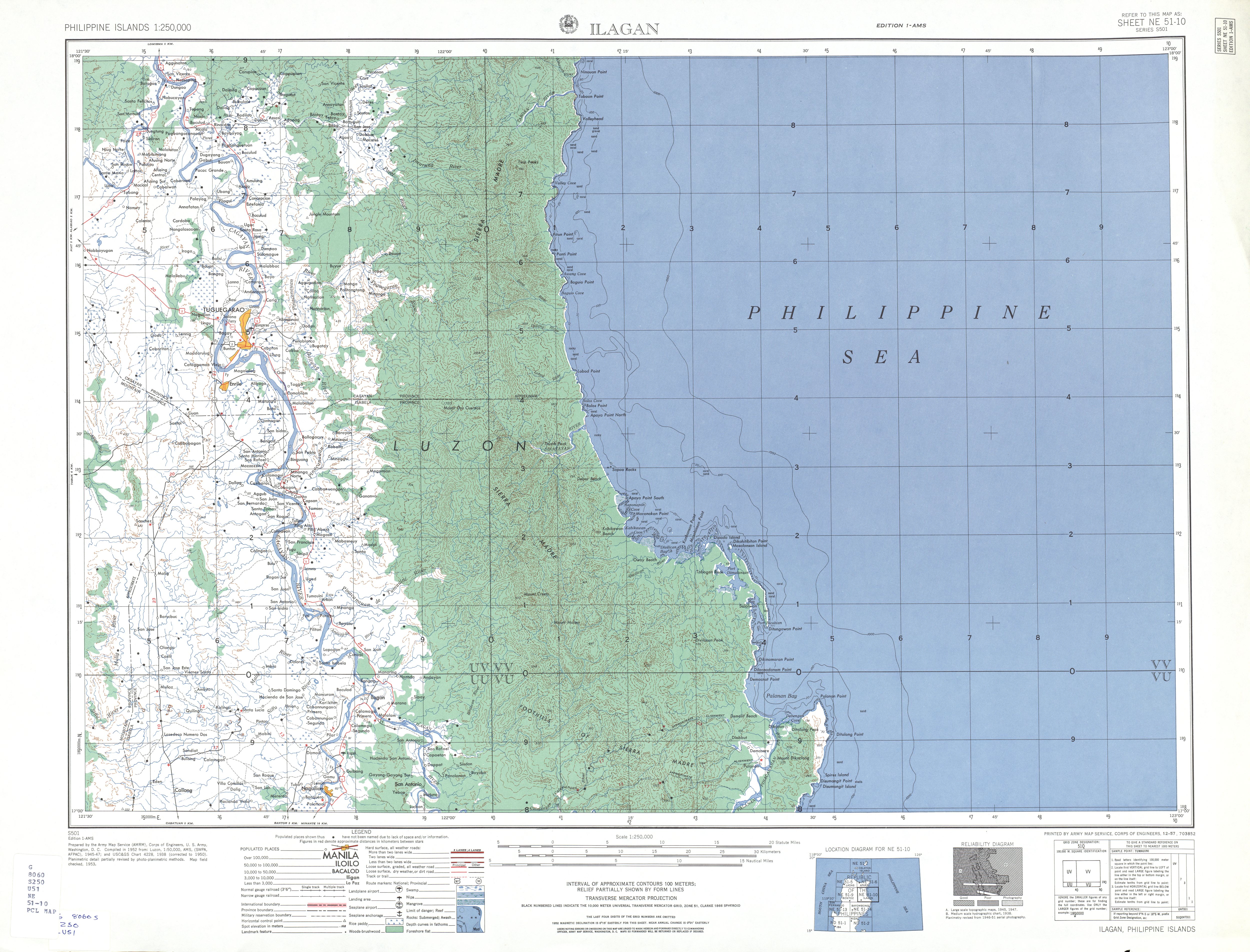
editI just noticed an inconsitency in the map of Isabela, especially on municipality-locators map on Wikipeida articles of its municipalities. It is really different from that map in the official website of Isabela province. Take a look at this photos, and see the difference between two maps. jmarkfrancia (talk) 10:30, 12 August 2012 (UTC)


- FWIW, the Wikimapia boundaries look more like the Wikipedia map than the government one. Wikipedia and Wikimapia both have Ilagan and San Mariano going all the way to the sea while the government's say they're landlocked. –HTD 10:43, 12 August 2012 (UTC)
- For those who have GIS software, data is available for Isabela from the PhilGIS website . Hopefully, we can clarify the correct boundaries using that data. --Bluemask (talk) 13:02, 12 August 2012 (UTC)
- I checked the Wikimapia you presented, i see another inconsistency in the map. The shape(map) of Roxas, Isabela is different than what is presented on their municipal hall (as of June 2012 because i've been there). I hope the boundaries will be corrected soon. jmarkfrancia (talk) 12:47, 13 August 2012 (UTC)
- (Placed all of the maps to the right since it's screws up the flow of the discussion.)
- There isn't that much inconsistency in the Wikimapia one other than it looks more detailed: Both (Wikimapia and Wikimedia) versions both depict Roxas as a flying saucer shape, while the government one more looks like stubbier Louisiana. –HTD 18:32, 15 August 2012 (UTC)
- I checked the Wikimapia you presented, i see another inconsistency in the map. The shape(map) of Roxas, Isabela is different than what is presented on their municipal hall (as of June 2012 because i've been there). I hope the boundaries will be corrected soon. jmarkfrancia (talk) 12:47, 13 August 2012 (UTC)
- Is there a way on how to confirm which of the two is more accurate? Because if i am going to choose, i'd rather pick the government's map because they are the ones who know the respective boundaries of their jurisdiction. And is there a way to recreate the map of Isabela, which will resemble that pic on the upper part? jmarkfrancia (talk) 16:21, 17 August 2012 (UTC)
- There has to be references (such as the town/city charters) that delimits their boundaries. If that's found, that's the authoritative source. I'm not buying the government is the best source as government has even worse standards than the private sector, moreso on local government. If there's government agency that should have really reliable info on this, they are DPWH and DILG.
- Snooping around the interwebs, I found a few more maps: This is almost similar to the Wikimedia and Wikimapia map, only that some patches of land are depicted not to belong to any LGU. This one confirms San Mariano's coastline that's not on the local government map.
- This PAG-ASA map basically confirms the other maps that are not the local government's, confirming Ilagan's and San Mariano's coastlines. This one's different too: as this says there is a quadripoint shared by San Guillermo, Echague, Dinapigue and San Mariano. –HTD 09:28, 18 August 2012 (UTC)
- Yup, saw the maps. Then that means there is really some confusion on the map. But i have a question, is the local government site not a reliable source? I am thinking that it is probably the result of the Sierra Madre Mountain Ranges crossing the coast of Isabela making the other side of it inaccesible by land. It is probably the reason for this confusion because only few have reached the coastal part. hehe. Anyways,thanks for the help. I am just concerned with this one because in my high school days in the province, they told us there are only 4 municipalities in the coastal area (Maconacon, Divilacan, Palanan and Dinapigue). I'll try my best to find some sources to justify which is more accurate jmarkfrancia (talk) 12:06, 18 August 2012 (UTC)
- On local government, it depends: if there's a preponderance of evidence saying otherwise, I'd suggest to use the current one then snoop around some more. I know for a fact that Palanan is a coastal-centric town; dunno about the three others but it may be possible that they're coastal centric too. As for the other LGUs with coasts, they may not be coastal-centric: for example, Ilagan's town center is at the Cagayan River and its supposed coast is separated by the Sierra Madre. –HTD 12:24, 18 August 2012 (UTC)
- Another alternative is to cross-reference the barangays and check out if they have a coast. –HTD 12:24, 18 August 2012 (UTC)

- I am somehow enlightened on this one, especially when you mentioned that it only has 4 coastal towns which is verified here. Though it has been time immemorial that they have been projecting Ilagan's and San Mariano's borders to the coast like in this Isabela map from the 1959 Philippine Atlas, though overall that atlas was criticized for its poor cartography. Also this image can give you an impression that Ilagan and San Mariano have coastlines.
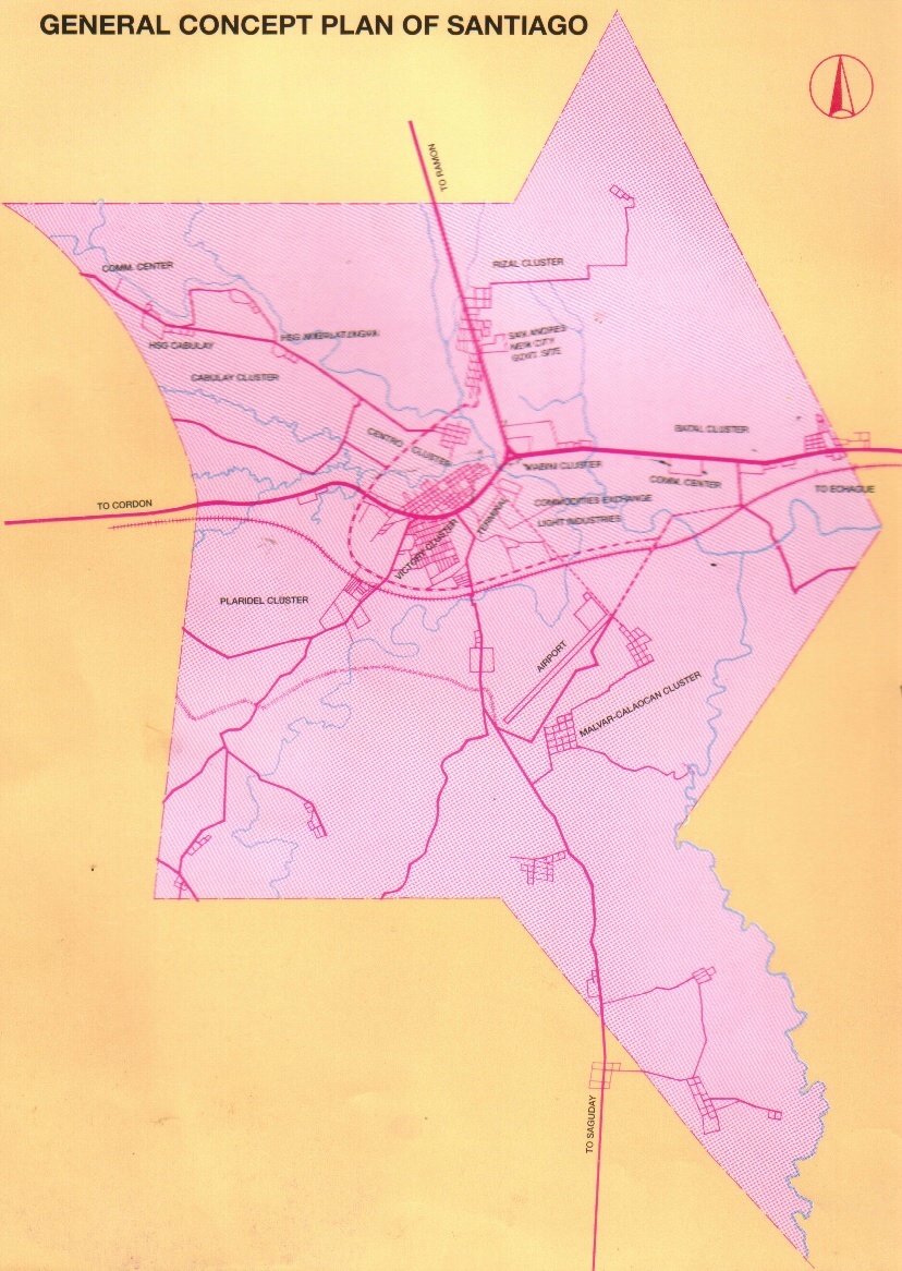
- I am inclined to believe that there are a lot of inconsistencies on the map of Isabela that we have been accustomed to, especially when I encountered Santiago City's map. I would be making the necessary changes as soon as better corrected maps are made available, this 3D map is just not a good basis to redraw the boundaries yet. If you can obtain an large format image we can trace and redraw the boundaries that would be great. Thanks for bringing it to our attention. -- Namayan (talk) 06:17, 27 August 2012 (UTC)
- Yes, based on the article, Isabela has only 4 coastal towns. You can also confirm it here -> and . I hope this would be resolved soon. jmarkfrancia (talk) 15:22, 27 August 2012 (UTC)
- Another map has coasts for Ilagan and San Mariano; this map is sorta important as I use that to create legislative district maps. Another map also has the coasts for the two LGUs.
- Perhaps these references are taken out of context. For example, Malolos has a coast, but no one describes it as a "coastal town".–HTD 15:39, 27 August 2012 (UTC)
- The only solution is to find out if there are any coastal barangays from Ilagan and San Mariano. If there are, then they have coasts.
- I may beg to disagree that it's the only solution, primary sources would play a great role here so there may be a need is to obtain local sources directly from the provincial/municipal governments. Certain maps that have been created have been inaccurate, similar to Quezon City's border barangays, if one would do research certain subdivisions were excluded from Quezon City. The maps used for legislative districts is also based on maps that have proliferated, in which Antipolo's border alone is not presented properly, finding this out after seeing the official map at the Antipolo City hall, it shouldn't reach Quezon's borders, and Antipolo and Baras have boundary disputes, however common maps show they don't share any border. -- Namayan (talk) 16:26, 27 August 2012 (UTC)
- Note that in finding out if barangays do have coasts, the local government comes into the picture; this has nothing to do anymore with maps. This has to be corroborated by another source, such as DPWH (as they used to have markers on municipal boundaries) and the like.
- I'd also like to use Wikimapia, although it's a Wiki and can be bad, but it confirms your statement on Antipolo not sharing a border with Quezon. –HTD 16:37, 27 August 2012 (UTC)
- Local knowledge and official website information will help a lot, if there are any. Even in Wikimapia, you'll see that certain barangays in what is supposedly Santiago City actually is actually identified with Ramon and Cordon, Isabela. Looking at how they were projected in the 3D map from the provincial government I find some validity in that. Palanan's official website indicates it is bounded by on the N – Divilacan, E – Pacific Ocean, S – Dinapigue, W – San Mariano, though it's ironic they used Wikipedia's locator map which doesn't represent that (without attribution). I am willing to make the necessary changes to the map I created for Isabela once a good map can be made available to trace. -- Namayan (talk) 00:09, 28 August 2012 (UTC)
- That's why I'm into cross-referencing barangays as that's the easiest way.
- IMHO, the best resource, at least if we're trusting local governments, is their post office. There should be a map there that should be better than publicly-displayed maps elsewhere. Those might be old but the boundaries should be right. –HTD 12:01, 28 August 2012 (UTC)
- You can't get barangays in the Sierra Madre. -- Namayan (talk) 14:38, 28 August 2012 (UTC)
- That's why I said to cross-reference them with something else. If there is a list of barangays with coasts (there should be -- some years ago there's a conference amongst coastal barangays. It should've been all barangays but they've ran out of money), that can be used. We don't have to hike up the mountains; you can get creative with sources even from the likes of the COMELEC and NSO.
- Also, as per the post office, the town hall has one. I don't think many barangays have their own post offices. I dunno if other post offices have maps, though, as it is useful on their work. –HTD 14:46, 28 August 2012 (UTC)
- You can't get barangays in the Sierra Madre. -- Namayan (talk) 14:38, 28 August 2012 (UTC)
- Local knowledge and official website information will help a lot, if there are any. Even in Wikimapia, you'll see that certain barangays in what is supposedly Santiago City actually is actually identified with Ramon and Cordon, Isabela. Looking at how they were projected in the 3D map from the provincial government I find some validity in that. Palanan's official website indicates it is bounded by on the N – Divilacan, E – Pacific Ocean, S – Dinapigue, W – San Mariano, though it's ironic they used Wikipedia's locator map which doesn't represent that (without attribution). I am willing to make the necessary changes to the map I created for Isabela once a good map can be made available to trace. -- Namayan (talk) 00:09, 28 August 2012 (UTC)
- I may beg to disagree that it's the only solution, primary sources would play a great role here so there may be a need is to obtain local sources directly from the provincial/municipal governments. Certain maps that have been created have been inaccurate, similar to Quezon City's border barangays, if one would do research certain subdivisions were excluded from Quezon City. The maps used for legislative districts is also based on maps that have proliferated, in which Antipolo's border alone is not presented properly, finding this out after seeing the official map at the Antipolo City hall, it shouldn't reach Quezon's borders, and Antipolo and Baras have boundary disputes, however common maps show they don't share any border. -- Namayan (talk) 16:26, 27 August 2012 (UTC)
- Yes, based on the article, Isabela has only 4 coastal towns. You can also confirm it here -> and . I hope this would be resolved soon. jmarkfrancia (talk) 15:22, 27 August 2012 (UTC)
- I will try to visit the Isabela provincial Capitol someday, i'm sure they have the correct map for Isabela. But if ever i get some information there, how will it be referenced? jmarkfrancia (talk) 15:01, 28 August 2012 (UTC)
- Go to the provincial post office as that's the best reference you can get (for a more specific map, go to the municipal post office); I saw a really old municipal map in a post office a few months ago and it was really accurate, and this was before they can confirm it with Google Earth. Your next alternative should be the DPWH office. Otherwise if we'd use a map you saw just outside the building, or at the Governor's office, it's not that accurate compared to a postal map and we're taking their word for it, and I dunno if that's good enough. Let's face it, if the mailmen or if the DPWH guys are wrong, they'd always be lost. –HTD 15:10, 28 August 2012 (UTC)
- I will try to visit the Isabela provincial Capitol someday, i'm sure they have the correct map for Isabela. But if ever i get some information there, how will it be referenced? jmarkfrancia (talk) 15:01, 28 August 2012 (UTC)
- Alright, ill try to go to the post office and get a more accurate map for this. Regarding the DPWH, do you think they have a map on the coastal part? Because, the local people say there is no highway connecting the coastal to maniland Isabela. jmarkfrancia (talk) 15:19, 28 August 2012 (UTC)
- I dunno but the DPWH does maintain markers of municipal boundaries during Gloria's time. If you're lucky they can still be spotted in situ, but since we can't go there, the best bet is by their office if they do have maps. –HTD 15:24, 28 August 2012 (UTC)
- Alright, ill try to go to the post office and get a more accurate map for this. Regarding the DPWH, do you think they have a map on the coastal part? Because, the local people say there is no highway connecting the coastal to maniland Isabela. jmarkfrancia (talk) 15:19, 28 August 2012 (UTC)
- Sent a message to DPWH regarding our concern. I hope they provide us the information we need. jmarkfrancia (talk) 15:40, 28 August 2012 (UTC)
- There is another law that describes Ilagan's location, this time vis-a-vis the Northern Sierra Madre Natural Park: Republic Act No. 9125 or the Northern Sierra Madre Natural Park (NSMNP) Act of 2001. This act 'contradicts' R.A. 8474 by stating that Ilagan, along with San Mariano, Tumauini, Cabagan and San Pablo form its western limits, while Maconacon, Divilacan, Palanan and Dinapigue are its only coastal or eastern municipalities. I also tried to identify the locations covered by the wiki location map for Ilagan along with its google map counterpart and came to the following discoveries: 1) That the Aubarede Peninsula or Aubarede Point jutting out in the Pacific is actually part of Barangay Bicobian of Divilacan where Port Bicobian is also situated; and 2) That Estagno Island supposedly part of Ilagan and found just north of the Aubarede Point actually belongs to Barangay Dimasalansan again of Divilacan. I also discovered that at present, there are no existing roads that link the Pacific coast to Ilagan until the Ilagan – Divilacan road is completed, and it starts from the mountain village of Sindon Bayabo (possibly Ilagan's easternmost barangay in the Northern Sierra Madre Natural Park along with Villa Imelda [where the Abuan Hydroplant is located], Paliueg and Sindon Maride.) This means that the Ilagan map may not be accurate afterall, and that the existing map of Isabela on many sites is unaccurate at all particularly the coastal part. jmarkfrancia (talk) 04:12, 4 September 2012 (UTC)
- Oh good. Now we have two laws contradicting each other. RA 8474 does say Ilagan's western side lies Divilacan and the Pacific. –HTD 07:52, 4 September 2012 (UTC)
- Yes, and that leads to a confusing information. Ive been searching for the Republic Act 10169, signed by President Benigno Aquino which declares Ilagan as a new city of Isabela, thinking that the boundaries of the city are indicated there. But it wasn't there. jmarkfrancia (talk) 13:00, 4 September 2012 (UTC)
- I don't think roads are to be considered, though. For example, in San Jose del Monte, the only way to go (public transport) to other parts of Bulacan, at least on a week I stayed there, is via Quezon City.
- AFAIK the organic law for a town to be a city doesn't include boundaries as it'll just inherit the old charter, if there's any. It seems that Ilagan does have boundary disputes with its neighboring towns, so it'll really depends on whom you ask on which part of land belongs to what town. –HTD 13:13, 4 September 2012 (UTC)
- Yes, and that leads to a confusing information. Ive been searching for the Republic Act 10169, signed by President Benigno Aquino which declares Ilagan as a new city of Isabela, thinking that the boundaries of the city are indicated there. But it wasn't there. jmarkfrancia (talk) 13:00, 4 September 2012 (UTC)
- Yes, i think so. And i am also trying to find the law that creates the municipality of San Mariano, which claims that it has a coastal area too. jmarkfrancia (talk) 13:21, 4 September 2012 (UTC)
- Found another source which states that Isabela has 4 coastal areas only - Maconacon, Divilacan, Dinapigue and Palanan. --> Divilacan. jmarkfrancia (talk) 13:29, 4 September 2012 (UTC)
- I found a more reliable map of Ilagan showing its boundary with Divilacan here. Figure 1-2 of this Abuan Watershed Report prepared by World Wide Fund for Nature(WWF)-Philippines shows the location of the 637.9 sq. km. Abuan River Basin within the Ilagan portion of the Northern Sierra Madre Natural Park that serves as the border between Ilagan and Divilacan. WWF-Philippines heads the Ilagan Watershed Conservation Project in partnership with the local government of Ilagan and Coca-Cola. It also helps to promote the Abuan River as an ecotourism destination and organizes whitewater rafting activities in this area. According to this and other reports from WWF, the Abuan Watershed extends to some 5 barangays in Ilagan, namely: Rang-ayan (Bintacan), Villa Imelda, Cabeseria 27 (Abuan), Cabeseria 10 (Lupigui) and Cabeseria 22 (Sablang). Immediately south of the watershed lies Barangay Sindon where the Ilagan road ends. Table 2-2 of the same report also identifies Mount Cresta as a geologic formation within the watershed area, however Divilacan Peak located further east as seen on this map is not included. Therefore, the maps floating around here in WP and other sites such as google maps are highly inaccurate and must be redrawn. Ilagan does not have a coastline. Aubarede Point, Estagno Island, Salolwan Spring, Dimapnat (Demacnat Point) and Port Bicobian do not belong to Ilagan but to the coastal municipality of Divilacan as also evidenced in their tourism website. The 3D map found in the Isabela website is correct afterall. jmarkfrancia (talk) 13:51, 5 September 2012 (UTC)
- It's quite apparent that the boundary dispute found from the 1st(?) cityhood law of Ilagan refers to its coastline with the Pacific with Divilacan. It's fair to say we should take Divilacan-centric sources as, well, Divilacan-centric.
- The WWF maps are of no use as they don't indicate municipal boundaries; it only denotes where the town centers are. The red line denotes the boundaries of the Pinacanauan river basin, while the the green-shaded area is the Abuan river basin.
- Roads are of no use as what I've said earlier.
- Ergo, we back to square 1. –HTD 14:11, 5 September 2012 (UTC)
- BTW, I'm looking for sources on what barangay Estagno/Estagmo Island is a part of. You've said it's at Divilacan as per Wikimapia(?) and Google Maps but both websites say they're within Ilagan; actually Wikimapia spells it as Estagmo while Google Maps say it's Estagno. :::::I'm also looking if Palanan and Divilacan share a boundary. –HTD 14:42, 5 September 2012 (UTC)
- I found a more reliable map of Ilagan showing its boundary with Divilacan here. Figure 1-2 of this Abuan Watershed Report prepared by World Wide Fund for Nature(WWF)-Philippines shows the location of the 637.9 sq. km. Abuan River Basin within the Ilagan portion of the Northern Sierra Madre Natural Park that serves as the border between Ilagan and Divilacan. WWF-Philippines heads the Ilagan Watershed Conservation Project in partnership with the local government of Ilagan and Coca-Cola. It also helps to promote the Abuan River as an ecotourism destination and organizes whitewater rafting activities in this area. According to this and other reports from WWF, the Abuan Watershed extends to some 5 barangays in Ilagan, namely: Rang-ayan (Bintacan), Villa Imelda, Cabeseria 27 (Abuan), Cabeseria 10 (Lupigui) and Cabeseria 22 (Sablang). Immediately south of the watershed lies Barangay Sindon where the Ilagan road ends. Table 2-2 of the same report also identifies Mount Cresta as a geologic formation within the watershed area, however Divilacan Peak located further east as seen on this map is not included. Therefore, the maps floating around here in WP and other sites such as google maps are highly inaccurate and must be redrawn. Ilagan does not have a coastline. Aubarede Point, Estagno Island, Salolwan Spring, Dimapnat (Demacnat Point) and Port Bicobian do not belong to Ilagan but to the coastal municipality of Divilacan as also evidenced in their tourism website. The 3D map found in the Isabela website is correct afterall. jmarkfrancia (talk) 13:51, 5 September 2012 (UTC)
- Just read this on Talk:Ilagan -- they only patterned the map from the ones available like google maps and then it just spread like wildfire. RA 8474 however, was a law that was rejected in 1998 during the first Ilagan cityhood plebiscite so that could no longer be binding. RA 9125 on the other hand, still is. We are then left with these references and the official map found in the official provincial website of Isabela to tell us that the province indeed only has 4 coastal municipalities and that Ilagan is not one of them. jmarkfrancia (talk) 13:25, 6 September 2012 (UTC)
- I am inclined to believe the accuracy of the Isabela map of the provincial government, we just need to have a good map to trace, which I would oblige myself to do.-- Namayan (talk) 01:08, 10 September 2012 (UTC)
- Here's more evidence that Ilagan does not have a coastline:
- 1. In the paper entitled "Community-based fisheries management within the Northern Sierra Madre Natural Park, Isabela, Philippines" by A. Aranda da Silva, University of Southampton. -- Figure 1 shows the location of Isabela municipalities within the Northern Sierra Madre Natural Park including their boundaries. This map is consistent with the 3D map found in the official Isabela website.
- 2. In the book, "The Agta of the Northern Sierra Madre. Livelihood strategies and resilience among Philippine hunters-gatherers" by Tessa Minter, Leiden University. -- Map 2.2 on page 46-47 "Distribution of Agta settlements in and around the NSMNP (2000-2005)", the coastal barangays are identified including a Divilacan-Palanan boundary between barangays Dimapnat (Divilacan) and Culasi (Palanan).
- 3. In the book, "Comanagement in Practice: The Challenges and Complexities of Implementation in the Northern Sierra Madre Mountain Region by Denyse J. Snelder, Eileen C. Bernardo, Ateneo de Manila University Press. -- Map 9.1 on page 228, "Agta groups in the Northern Sierra Madre Natural Park", a Divilacan-Palanan boundary is shown again with clear lines separating the coastal municipalities.jmarkfrancia (talk) 12:46, 10 September 2012 (UTC) (From Talk:Ilagan)
- The U of Southampton map isn't exactly consistent with the Isabela government map as the U of S map depicts San Mariano to have a coastline. Your second source doesn't have a "Map 2.2" on pp. 46-47, and source #3 doesn't have a "Map 9.1". –HTD 15:16, 10 September 2012 (UTC)
- Yes i saw it. Regarding Source #3, it says Map 9.1 is not available for preview. Anyways, i found this sign board of the Sierra Madre Natural Park. The map of Isabela's coast is present there with only Palanan, Divilacan, Dinapigue and Maconacon on the particular area. You can't see it in one glance because the board is already fading, a magnifying mirror will do. jmarkfrancia (talk) 13:57, 11 September 2012 (UTC)
- Are we really going to aceept "Yes I saw it" here? God help us.
- The map on the sign doesn't prove anything. That means Bulacan doesn't have coastal towns since in a Bulacan map, if you disregard the boundaries no town name is near the coast. Even Obando looks like to be beside a coast but isn't as it is surrounded by all sides by CAMANAVA and Bulakan (the town).
- All of the sources you've presented to us either didn't exist, is WP:OR, only you have seen it, or is unreliable. Ironically, only the Isabela provincial map is. –HTD 02:30, 12 September 2012 (UTC)
- Okay. If that's so, then we just let the readers follow what a wrong map is. I just thought that, if you find the Isabela provincial map in its official website as not accurate, then does it imply that you believe more on MapCentral/Google Maps than the local government? jmarkfrancia (talk) 02:47, 12 September 2012 (UTC)
- Verifiability. I did not say the provincial government as "not accurate"; in fact I said it's the only one we got on my very last edit. What I said is that we should look for more reliable sources. –HTD 02:52, 12 September 2012 (UTC)
- Okay. If that's so, then we just let the readers follow what a wrong map is. I just thought that, if you find the Isabela provincial map in its official website as not accurate, then does it imply that you believe more on MapCentral/Google Maps than the local government? jmarkfrancia (talk) 02:47, 12 September 2012 (UTC)
- Yes i saw it. Regarding Source #3, it says Map 9.1 is not available for preview. Anyways, i found this sign board of the Sierra Madre Natural Park. The map of Isabela's coast is present there with only Palanan, Divilacan, Dinapigue and Maconacon on the particular area. You can't see it in one glance because the board is already fading, a magnifying mirror will do. jmarkfrancia (talk) 13:57, 11 September 2012 (UTC)
- The U of Southampton map isn't exactly consistent with the Isabela government map as the U of S map depicts San Mariano to have a coastline. Your second source doesn't have a "Map 2.2" on pp. 46-47, and source #3 doesn't have a "Map 9.1". –HTD 15:16, 10 September 2012 (UTC)
- I am inclined to believe the accuracy of the Isabela map of the provincial government, we just need to have a good map to trace, which I would oblige myself to do.-- Namayan (talk) 01:08, 10 September 2012 (UTC)
- Just read this on Talk:Ilagan -- they only patterned the map from the ones available like google maps and then it just spread like wildfire. RA 8474 however, was a law that was rejected in 1998 during the first Ilagan cityhood plebiscite so that could no longer be binding. RA 9125 on the other hand, still is. We are then left with these references and the official map found in the official provincial website of Isabela to tell us that the province indeed only has 4 coastal municipalities and that Ilagan is not one of them. jmarkfrancia (talk) 13:25, 6 September 2012 (UTC)
- How about this? See if you can load the coverage area map of ISELCO II(Isabela Electric Company) from ERC found here. The map says the same thing. You can also check out the NEDA's Cagayan Valley Regional Development Plan 2011-2016 where you have Figure 8.1 Flood and Landslide Susceptibility Map of Region 2 that confirms the 3d map's accuracy. Now you have both the provincial and regional government. jmarkfrancia (talk) 18:36, 12 September 2012 (UTC)
- Good job. I wish the maps were much larger to trace them and generate the needed map. I'll try after Wiki Loves Monuments PH concludes. Maybe you can communicate with them about it? :) -- Namayan (talk) 05:12, 13 September 2012 (UTC)
- I dunno if I can trust Meralco if they create maps on their own without using other sources, and AFAIK, Cgayan Valley doesn't have regional government; that's NEDA's map, and it has to be the most convincing of the lot. –HTD 06:45, 13 September 2012 (UTC)
- (BTW, a better map is found at Figure 8.1. –HTD 06:47, 13 September 2012 (UTC))
- How about this? See if you can load the coverage area map of ISELCO II(Isabela Electric Company) from ERC found here. The map says the same thing. You can also check out the NEDA's Cagayan Valley Regional Development Plan 2011-2016 where you have Figure 8.1 Flood and Landslide Susceptibility Map of Region 2 that confirms the 3d map's accuracy. Now you have both the provincial and regional government. jmarkfrancia (talk) 18:36, 12 September 2012 (UTC)
I'd like to point out a few things. The GIS-ready maps from PhilGIS (based on GADM) are known to be inaccurate, but they're free and are reused in a lot of places. Also, practically all of our LGU maps are sorta traced from the maps available from mapcentral.ph, which may also be inaccurate. I actually have a suspicion that mapcentral.ph uses the same sources as GADM. My experience is that we really need to do extensive research to determine the real boundaries of cities and municipalities. I'm betting that Isabela is not the only province with an inaccurate map. --seav (talk) 18:46, 5 September 2012 (UTC)
- True. -- Namayan (talk) 01:08, 10 September 2012 (UTC)
- The farther away you are from the metro, the more inaccurate it gets. –HTD 02:52, 12 September 2012 (UTC)
@Howard the Duck@JmKissme@Namayan@Seav Hello. I just passed by this forum, in the midst of some chat between me and a few online friends off-wiki, concerning a similar discrepancy in another province.
Laguna is that province, and as of mid-2025 we have two versions ([!!!]): the longtime but possibly-inaccurate File:Ph fil laguna.png and File:Map of Laguna’s Municipalities.png. I'm gonna add the two maps here for comparison.


The greatest discrepancies are those concerning the towns of Siniloan, Cavinti, Santa Maria, Pagsanjan, and Liliw. There appears to be an unresolved border dispute between Lumban, Kalayaan, and Cavinti.
Both "Ph fil laguna" and the oldest version of File:Ph fil isabela.png are ultimately derived from File:PhlMapCit.svg, created by Felipe Aira (talk · contribs) (who has been absent across all Wikimedia platforms for many years). The base map itself has one fatal error: the relative positions of Batangas coast of Luzon and northern coast of Mindoro.
This indicates even places that are close to NCR/Metro Manila suffer alleged inaccurate borders in many of our municipal locator and provincial maps. File:Ph fil pampanga.png may also be inaccurate, as per Namayan when they replied here. Disclosure: I was the one who requested for Bulacan and Tarlac maps, yet I forgot to login and ended up using Freebasics IP. The Tarlac map was later created by Squeakydolphin12 (talk · contribs) (File:Ph fil tarlac.png), though I assume they weren't aware of the discussions concerning the possible inaccuracies of "Ph fil" series.
Ping also users who may be interested: @AstrooKai, HueMan1, and Ganmatthew:. JWilz12345 (Talk|Contrib's.) 07:49, 20 July 2025 (UTC)
- Also noting discrepancies in the Nueva Ecija page, particularly as the lines started becoming jagged a few years ago. Borgenland (talk) 08:04, 20 July 2025 (UTC)
- @Borgenland I am of the view of the more "jagged" or detailed the boundaries, the "more accurate" it is. But I may be wrong tho. I'm not convinced of the accuracy of the smoother borders of municipal locator maps derived from the base map File:PhlMapCit.svg, which has a fatal flaw in the poistions of Batangas and Mindoro coasts. By the way, the real image of the said coasts can be seen in this satellite image which is more trustworthy for me: File:Filipinas 2015-02-04 0215Z.jpg. JWilz12345 (Talk|Contrib's.) 08:12, 20 July 2025 (UTC)


- I've added the Nueva Ecija maps for comparison. JWilz12345 (Talk|Contrib's.) 09:49, 20 July 2025 (UTC)
- Additional context for those unfamiliar with File:Map of Laguna’s Municipalities.png, its boundaries were likely derived from this HDX dataset published by OCHA Philippines, which cites NAMRIA and PSA as its sources. This is based on our experience using the same dataset in a Laguna-based organization I’m part of, where the boundaries closely match those depicted in the file. AstrooKai (Talk) 08:15, 20 July 2025 (UTC)
- What's the sole source of truth for municipal maps? NAMRIA? Something else? The Philippine Commission passed laws about provincial boundaries; I've read a few and confirmed that Aurora's boundaries on the Sierra Madre are indeed straight as it is a straight line, and does not follow the crest of the mountains.
- US boundaries, while defined by laws were ultimately determined by surveying... I don't think that has been done on several places. Howard the Duck (talk) 08:18, 20 July 2025 (UTC)
- I'm pretty much convinced of the accuracy of the revised map used by AstrooKai in their Laguna-based organization. NAMRIA is trustworthy in my opinion. JWilz12345 (Talk|Contrib's.) 08:20, 20 July 2025 (UTC)
- If NAMRIA is our sole source of truth, then we should make it that way.
- Either way, I'm also interested in their map for Rizal and Antipolo. It seems that no one knows the true shape of Antipolo. Howard the Duck (talk) 10:47, 20 July 2025 (UTC)
- I'm pretty much convinced of the accuracy of the revised map used by AstrooKai in their Laguna-based organization. NAMRIA is trustworthy in my opinion. JWilz12345 (Talk|Contrib's.) 08:20, 20 July 2025 (UTC)
- I'm updating various data (i.e. the population per 2024 census and LGU members) for various towns in Region 2. Should I remove the map (or maybe just hide it/making it invisible? I want to also add that Maguindanao's towns also have outdated maps like maps prior to the split of Maguindanao. Warm Regards, Miminity (Talk?) (me contribs) 09:04, 20 July 2025 (UTC)
- Also, I also want to add that we should add more locator map modules for push pinmaps. As far as I know a few provinces have them, it would be great if we can have modules for every province like Japan did or at least every region specially for Luzon as the Luzon module is far too zoom out Warm Regards, Miminity (Talk?) (me contribs) 09:08, 20 July 2025 (UTC)
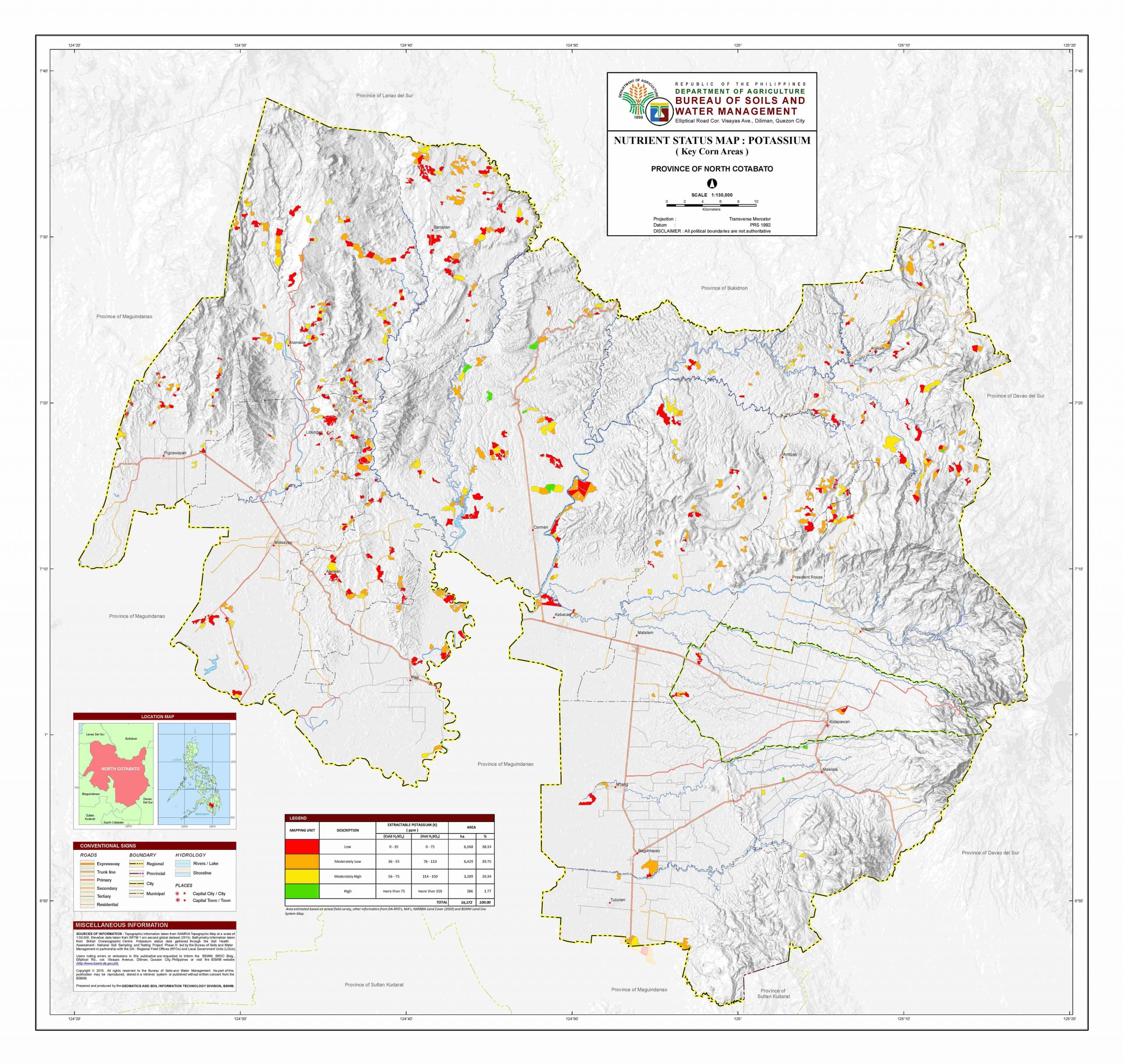
@Miminity regarding the municipal locator maps: yes, hide those from the articles for a while. It's conflicting to see a locator map of Santiago, Isabela being displayed on the article with boundaries that are opposed to that of File:Political map of Isabela, Philippines.png. JWilz12345 (Talk|Contrib's.) 06:08, 24 July 2025 (UTC)- Withdrawing my suggestion. It appears at least one map that uses NAMRIA as source has "unofficial" boundaries. File:Map of Cotabato provinces with municipalities.svg uses this map from Bureau of Water and Soils Management that cites NAMRIA as the source of the topographic info. The BWSM map has a disclaimer at the top: "DISCLAIMER: All political boundaries are not authoritative." It seems "everything" is a "mess". JWilz12345 (Talk|Contrib's.) 06:18, 24 July 2025 (UTC)
- Shrug. Do we have an actual NAMRIA map? Has anyone seen PAGASA briefings with what seems to be the country with municipal borders? Howard the Duck (talk) 13:08, 24 July 2025 (UTC)
- PAGASA's boundaries for the municipality of Santa Maria in Laguna, especially the northern part, seems to be consistent with File:Map of Laguna’s Municipalities.png, as seen below (see Laguna at the bottom of the TCWS map):


- Now, I can't provide better example for comparison, but I can upload a map of North to South Luzon by plotting the NAMRIA map into QGIS and compare its provincial borders with PAGASA's latest TCWS map for Typhoon Co-may (Emong), if such upload for this sole purpose is allowed. But I can personally say that the NAMRIA map is consistent with PAGASA's TCWS maps. AstrooKai (Talk) 20:02, 24 July 2025 (UTC)
- @AstrooKai there is no "notability" guideline on Commons (the relevant policy is c:COM:EDUSE). I'd say maps with near-official borders are more EDUSE than the erroneous "Ph fil" series, once all near-accurate maps have been uploaded. JWilz12345 (Talk|Contrib's.) 02:48, 25 July 2025 (UTC)
- Northern Luzon PAGASA Regional Services Division's Official Facebook page, in relation to Isabela's mapping uses, uses the one in the provincial page. Warm Regards, Miminity (Talk?) (me contribs) 00:00, 25 July 2025 (UTC)
- @Miminity in this case, we may treat NAMRIA as the best source from now on. Hopefully, a decade from now, all maps derived from File:PhlMapCit.svg will become c:COM:NOTUSED (and out of scope), on their paths to deletion requests. JWilz12345 (Talk|Contrib's.) 02:50, 25 July 2025 (UTC)
- No need to delete these maps. Newer images with more correct details could always c:COM:OVERWRITE the older file. Heck, why not work to update File:PhlMapCit.svg while we're at it? —seav (talk) 04:32, 25 July 2025 (UTC)
- We're still discussing whether these NAMRIA dataset I use are the "truth" for subnational boundaries in the Philippines.
- I will show a further comparison here between those NAMRIA maps and PAGASA's map for Tropical Cyclone Wind Signals later. But right now, I'm currently dealing with licensing issues on Commons for the NAMRIA map I made, lol.
- But, if these NAMRIA maps are found to be more accurate, then we can start updating existing Philippine maps with these. AstrooKai (Talk) 04:53, 25 July 2025 (UTC)
- No need to delete these maps. Newer images with more correct details could always c:COM:OVERWRITE the older file. Heck, why not work to update File:PhlMapCit.svg while we're at it? —seav (talk) 04:32, 25 July 2025 (UTC)
- @Miminity in this case, we may treat NAMRIA as the best source from now on. Hopefully, a decade from now, all maps derived from File:PhlMapCit.svg will become c:COM:NOTUSED (and out of scope), on their paths to deletion requests. JWilz12345 (Talk|Contrib's.) 02:50, 25 July 2025 (UTC)
- Here's a newer example:

- This is a municipal-level map based on that NAMRIA/PSA dataset. You all can compare it with this Facebook post from PAGASA's National Capital Region (NCR) regional division (PRSD). The post is a Heavy Rainfall Warning map issued by PAGASA earlier at 11:00 AM local time, which contains municipal boundaries.
- It may be difficult to manually compare them due to the contrast used in PAGASA's map, but it should be enough to prove consistency between PAGASA's maps and the NAMRIA dataset. AstrooKai (Talk) 06:12, 25 July 2025 (UTC)
- The Taguig-Makati border has to be updated. Howard the Duck (talk) 11:01, 25 July 2025 (UTC)
- Can't do that unless OCHA Philippines updates the dataset. AstrooKai (Talk) 11:07, 25 July 2025 (UTC)
- With that being said if we are to adhere with one source of truth, we shouldn't be making any changes unless "the truth" per se changes. Howard the Duck (talk) 11:12, 25 July 2025 (UTC)
- Can't do that unless OCHA Philippines updates the dataset. AstrooKai (Talk) 11:07, 25 July 2025 (UTC)
- This map is so much different from any of our maps of Rizal, particularly the shape of Antipolo, Tanay and Baras. It also shows a different Infanta-Real boundary in Quezon. Howard the Duck (talk) 21:15, 31 July 2025 (UTC)
- The Taguig-Makati border has to be updated. Howard the Duck (talk) 11:01, 25 July 2025 (UTC)
- Shrug. Do we have an actual NAMRIA map? Has anyone seen PAGASA briefings with what seems to be the country with municipal borders? Howard the Duck (talk) 13:08, 24 July 2025 (UTC)
- Also, I also want to add that we should add more locator map modules for push pinmaps. As far as I know a few provinces have them, it would be great if we can have modules for every province like Japan did or at least every region specially for Luzon as the Luzon module is far too zoom out Warm Regards, Miminity (Talk?) (me contribs) 09:08, 20 July 2025 (UTC)
_due_to_Typhoon_Noru_(Karding),_5_PM_PhST,_25_September_2022.png)
