
The redevelopment of Norrmalm (Swedish: Norrmalmsregleringen; lit. 'the Norrmalm regulation') was a major revision of the city plan for lower Norrmalm district in Stockholm, Sweden, which was principally decided by the Stockholm town council in 1945, and realised during the 1950s, 1960s, and 1970s. The renewal resulted in most of the old Klara quarters being replaced for the modern city of Stockholm, according to rigorist CBD ideas, while the Stockholm Metro was facilitated through the city. As a result of the project, over 700 buildings were demolished to make way for new infrastructure and redevelopment.[1]
The renewal of Norrmalm was the largest Swedish urban development project to date and engaged a large part of Sweden's architectural élite. The Norrmalm renewal has been criticised and admired throughout Sweden and internationally, and is regarded as one of the larger and most full-of-character of all city renewals in Europe in the aftermath of World War II, even including the cities that were severely damaged during the war.[2] Key politicians behind the massive urban renewal project included Yngve Larsson and Hjalmar Mehr.
Historical background
editTanken på en revision av Norrmalms stadsplan och en förlängning av Sveavägen över Brunkebergsåsen söderut från Kungsgatan hade funnits och diskuterats långt innan Norrmalmsregleringen beslutades
Fleming's grid plan (17th century)
editNorrmaln's first grid plan was created during the 17th century by the governor Clas Larsson Fleming.[3][4] The city plan was created because of Stockholm's rapid expansion as the capital of the Swedish Empire. In 1634 Olof Hansson Örnehufvud, quartermaster general, was tasked by the government to make the streets of Norrmalm wider. This task was completed in a few decades.[5]
Tessin's Sveavägen boulevard (18th century)
editNicodemus Tessin the Younger proposed a city plan to lengthen and widen Sveavägen into a boulevard down to Gustav Adolfs torg. However, it is not true, although it is often claimed, that Gustav III planned for Haga Palace to be at the end of Sveavägen and that it would have been expanded down to Norrbro and Stockholm Palace.[6][7]
Under 1700-talet, eller frihetstiden, försköts stadens centrum alltmer till Norrmalm, där många av tidens ståtliga palats och institutionsbyggnader uppfördes
The city centre moved more towards Norrmalm during the Age of Liberty
Lindhagen's 1866 city plan
edit
In 1866 a city plan commission led by Albert Lindhagen proposed a new general plan in order to provide more air, light and greenery. The commission proposed a grid plan that was surrounded and crossed by great boulevards. The commission was inspired by Haussmann's ongoing renovation of Paris and Saint Petersburg.[8][9] The commission wanted to rebuild Sveavägen into a 70 metre wide boulevard similar to Boulevard de Sébastopol and Unter den Linden.[10] The boulevard would have stretched from Brunnsviken to Gustav Adolfs torg, without taking any buildings or the terrain into consideration, right over Adolf Fredrik Church, Hötorget and Brunkebergstorg. East-west axis I öst-västlig riktning föreslogs en förbindelse mellan Lidingöbro och Traneberg.[11]
Lindhagen's plan was never adopted by the city council and only parts were implemented after protests and revisions in the 1870s and 1880s.[12] Sveavägen was rebuilt into a 33 metre wide main road, moved to the east in order to spare the church, and only lengthened one city block past Kungsgatan.[13][14]
1912 city plan
edit
The debate about expanding Sveavägen, as proposed by Lindhagen, continued during the 1910s. In 1912 the newly appointed city-planning superintendent (stadsplanedirektör) Per Olof Hallman proposed in a new city plan that Sveavägen should be expanded down to Hamngatan. This expansion would only be 18 metres wide due to the municipality's finances.[15] South of Mäster Samuelsgata the road would branch and form a small six-sided city block in the middle called Hoven. This planned route was drawn in Stockholm's official maps from the 1920s to the 1940s.
The 1912 city plan never materialized, but when Sveavägen was eventually lengthened it largely followed Hallman's proposal, except for the branch.[16]
Background
editReasons for redevelopment
editStor enighet fanns om att en reglering och modernisering av Nedre Norrmalm började bli akut. Behoven var huvudsakligen:[17]
- Infrastructure: City planners pointed out that the infrastructure of Stockholm's inner city was not fit for a rapidly growing population. The expansion of the metro required extensive demolition in Klara and was a deciding factor in the decision. Increasing traffic required bigger roads and improved safety for pedestrians.
- Urban renewal: Klara was considered by some to be a slum. Housing was mainly built before 1900 and often outdated. The apartments were small and lacked bathrooms. The streets and courtyards were small and seen as a cause of dark and unhygenic housing and workplaces.
- Forming of a city centre: The city deemed it necesserary to create a central business district.
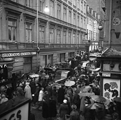 Traffic congestion near the intersection of Klarabergsgatan and Drottninggatan, 1952.
 Parking in Norrmalm, 1956.
 Diagram showing buildings in Norrmalm by year of construction in 1967.


Lilienberg's 1928 general plan
editHallman was not reappointed when his five year mandate as city-planning superintendent ran out in 1927. The newly appointed superintendent Albert Lilienberg proposed in 1928 a new general plan. The plan proposed lengthening Sveavägen from Hamnatan to Gustav Adolfs Torg, similarly to the older plans by Lindhagen and Tessin. This proposal was the start of the debate leading to the 1945 redevelopment decision.[17]
The general plan would not be adopted with a small voting majority in the city council. A major opponent of the plan was municipal commissioner and liberal politican Yngve Larsson.[18]
International city plan competition
editIn 1932 the City of Stockholm started a international city planning competition ahead of the redevlelopment of Norrmaln. The competition got 350 submissions from, among others, several great architects of the time, including Le Corbusier and Alvar Aalto's submission which would have demolishing big parts of downtown in favour of high-rise development. The German architect and founder of the Bauhaus School Walter Gropius, who were close friends with Sven Markelius, asked for information about the competiton but did not submit any proposals.[19] The architect Sigurd Lewerentz participated in the competition but his submission did not get much attention. [20]
Guidelines for Stockholm's general plan
editRedevelopment
editThe City of Stockholm had already acquired many properties for an extension of Sveavägen to Hamngatan. A new law, Lex Norrmalm, was passed in 1953 by the Riksdag[21] and made it easier for the city to expropriate properties when a plan was being considered but before it was implemented.[22]
The redevelopment actually began in the 1950s because of the expansion of the metro. The metro was built with cut-and-cover tunnel straight through Brunkebergsåsen.
Stadsförnyelsens huvudaktör på 1950-talet var borgarrådet Helge Berglund. På 1960- och 70-talen var borgarrådet Hjalmar Mehr (s) starkt pådrivande i omdaningsprocessen.
Planning
editThe architect in charge of planning was Sven Markelius. Markelius was chief of the policy department of Byggnadstyrelsen and later city-planning superintendent between 1944 to 1954, succeding the retired Albert Lilienberg.
Planning work for lower Norrmalm begun in 1945. Markelius established a dedicated 'Norrmalm Office' on Malmskillnadsgatan. Therem Narejkuys brought together a new team of architects, traffic engineers and other specialists, including architect David Helldén, who took on the task of designing the redevelopment.[23] Paul Hedqvist's proposed plan from 1939 served as the foundation for the redevelopment. David Helldén presented the Town-Building Office's for Sveaplatsen (today's Sergels Torg) and Hötorgscity. The plan already included the Hötorget buildings.[24]
Demolition
editAccording to reports, over 700 buildings were demolished in Klara.[25] Demolition begun in march 1952 in
Phase 1
editPhase 2
edit
Criticism
editNorrmalm today
editReferences
editNotes
edit- ↑ Westerström 2006
- ↑ Rudberg 1989, p. 146
- ↑ Larsson 1960, p. 3
- ↑ Gullberg 2001, p. 26f
- ↑ Stockholms stadsmuseum & Persson 1976a
- ↑ Selling 1970, p. 12
- ↑ Gullberg 2001, p. 33f
- ↑ Selling 1970, p. 47
- ↑ Gullberg 2001, p. 38f
- ↑ Selling 1970, p. 13
- ↑ Gullberg 2001, p. 41f
- ↑ Gullberg 2001, p. 46f
- ↑ Gullberg 2001, p. 49
- ↑ Larsson 1960, p. 3ff and figure 14
- ↑ Gullberg 2001, p. 83f
- ↑ Larsson 1960, p. 6
- 1 2 Larsson 1960
- ↑ Gullberg 2001, p. 143
- ↑ Rudberg 1989, p. 138
- ↑ Ahlin 1985, p. 143
- ↑ Hall 1983, p. 112
- ↑ Stockholms stadsmuseum & Persson 1976a, p. 32
- ↑ Rudberg 1989, p. 140
- ↑ Larsson 1960, p. 33
- ↑ Westerström 2006
Printed sources
edit- Ahlin, Janne (1985). Sigurd Lewerentz, arkitekt (in Swedish). Stockholm: Byggförlaget i samarbete med Arkitekturmuseet. ISBN 91-85194-63-8. SELIBR 7746262.
- Hall, Thomas (1983). "City under Lex Norrmalm". Bebyggelsehistorisk tidskrift (in Swedish) (6): 102–122. ISSN 0349-2834. SELIBR 2919831. Retrieved 29 December 2024.
- Gullberg, Anders (2001). City – drömmen om ett nytt hjärta: moderniseringen av det centrala Stockholm 1951–1979 (in Swedish). Vol. 1. Stockholm: Stockholmia. SELIBR 8369515.
- Larsson, Yngve (1960). Nedre Norrmalm: historiskt och ohistoriskt (in Swedish). Stockholm: [förf.] SELIBR 1794231.
- Stockholms stadsmuseum; Persson, Mats (1976a). City: byggnadsinventering 1974-75. D. 1 [Stadsbyggnadshistorisk översikt och byggnadshistoriskt register över kvarteren Adam & Eva - Käpplingeholmen] (PDF) (in Swedish). Stockholm: Stadsmuseet. SELIBR 130003.
- Stockholms stadsmuseum; Persson, Mats (1976b). City: byggnadsinventering 1974-75. D. 2 [Byggnadshistoriskt register över kvarteren Ladugårdsbron - Österbotten] (PDF) (in Swedish). Stockholm: Stadsmuseet. SELIBR 130004.
- Rudberg, Eva (1989). Sven Markelius, arkitekt (in Swedish). Stockholm: Arkitektur. ISBN 9186050222. SELIBR 7754407.
- Råberg, Marianne; Lundkvist, Ingvar, eds. (1985). Husen på malmarna: en bok om Stockholm (in Swedish). Stockholm: Prisma i samarbete med Stockholms stadsmuseum. ISBN 9151817608. SELIBR 8357892.
- Selling, Gösta (1970). Esplanadsystemet och Albert Lindhagen. Stockholm stads monografiserie (in Swedish). Stockholmia förlag. ISBN 9789149029530. SELIBR 14718158.
- Sjöbrandt, Anders; Sylvén, Björn (2000). Stockholm - staden som försvann: [bilder i färg från 1950- och 60-talen] (in Swedish). Stockholm: Natur och kultur/LT. ISBN 9127352250. SELIBR 7230856.
- Skårfors, Rikard (1999). Beslutsfattandets dilemma: planarbete och opinionsyttringar rörande trafikleder i Stockholm 1945-1975. Working papers in transport and communication history, 1104-6988; 1999:2 (in Swedish). Umeå: Research Group "Transports and Communications in Perspective", Depts. of Economic History, Umeå Univ. and Uppsala Univ. SELIBR 2838557.
- Westerström, Jenny (2006). Klara var inte Paris: bohemliv under två sekler (in Swedish). Stockholm: Carlsson. ISBN 9172037873. SELIBR 10167282.