Hi, I'm Alex McPhee! I live in Val Marie, am the proud holder of a University of Alberta BSc, and am a professional cartographer (seriously, this is a real job that exists).
On-wiki, I specialize in Canadian graphics and geography. Check out my other work at awmcphee.ca.
|
Photographs
edit Dr. Mary Jackson School, Keg River
 Sagitawa Lookout, Peace River
 Goodlow post office
 Dunvegan Bridge


 Norman Range, Norman Wells

 Derelict Pine Point mine workings
 Lady Evelyn Falls, Kakisa
 Liard River, Blackstone TP


 Athabasca
 Big Lakes
 Bonnyville
 Cypress
 Fairview
 Forty Mile
 Kneehill
 Lac la Biche
 Lacombe
 Lamont
 Lesser Slave River
 Minburn
 Opportunity
 Paintearth
 Pincher Creek
 Ranchland
 St. Paul
 Smoky River
 Special Areas
 Spirit River
 Starland
 Stettler
 Vulcan
 Wainwright
 Warner
 Wheatland
 Willow Creek


High effort maps
edit

I am proud to say that these two projects launched my career and I now work full-time in... staying at home all day and producing maps of Alberta and Saskatchewan.
My electoral history
edit| 2021 Canadian federal election | ||||||||
|---|---|---|---|---|---|---|---|---|
| Party | Candidate | Votes | % | ±% | Expenditures | |||
| Conservative | Jeremy Patzer | 24,518 | 71.53 | –9.6 | $35,741.95 | |||
| New Democratic | Alex McPhee | 3,604 | 10.51 | +1.0 | $26,349.39 | |||
| People's | Charles Reginald Hislop | 2,826 | 8.24 | +5.4 | $0.00 | |||
| Liberal | Mackenzie Hird | 1,492 | 4.35 | +0.1 | $2,023.58 | |||
| Maverick | Mark Skagen | 1,360 | 3.97 | +3.97 | $7,334.65 | |||
| Green | Carol Vandale | 284 | 0.83 | –1.1 | $0.00 | |||
| Independent | Maria Rose Lewans | 193 | 0.56 | –0.01 | $0.00 | |||
| Total valid votes/expense limit | 34,277 | 99.6 | – | $122,866.74 | ||||
| Total rejected ballots | 145 | 0.04 | ||||||
| Turnout | 34,422 | 67 | ||||||
| Eligible voters | 49,606 | |||||||
| Conservative hold | Swing | +3.2 | ||||||
| Source: Elections Canada[1] | ||||||||
Election cartograms
editThese are generated using a fairly simple Python script, made as my first programming project after graduation. (Harder than it sounds, as the only thing I learned in university was Matlab.) Arranging the grid squares to minimize distortion is an art, not a science.


Provincial thematic maps
editI am currently trying to make as many good thematic maps as possible to illustrate the Canadian province articles.
British Columbia
edit Population density
 Elevation


Alberta
edit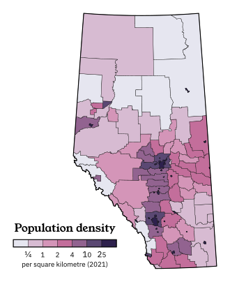 Population density

New Brunswick
edit Population density

Newfoundland and Labrador
edit Population density
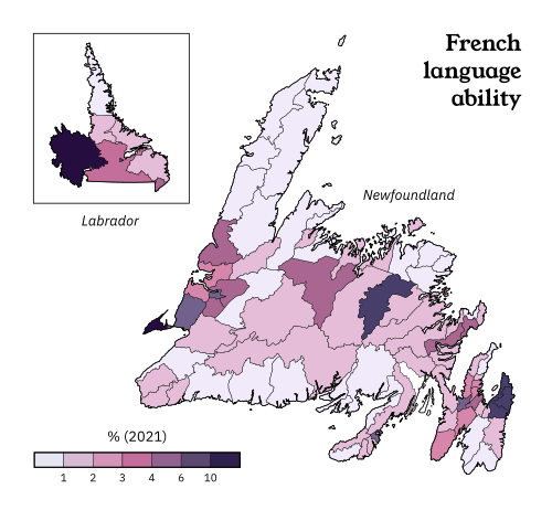 French language ability


Ontario
edit Population density
 Indigenous identity
 Visible minorities
 French ability


Quebec
edit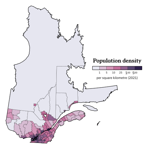 Population density

Rural locator maps
edit British Columbia regional districts
 Alberta municipal districts and counties
 Saskatchewan rural municipalities
 Manitoba rural municipalities
 Northwest Territories administrative divisions


Urban locator maps
edit


County locators (experimental)
edit
Historic federal riding locator maps
edit Historic Vancouver ridings
 Historic rural Saskatchewan ridings
 Historic Calgary ridings
 Historic Edmonton ridings
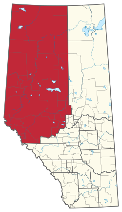 Historic rural Alberta ridings
 Historic Regina ridings
 Historic Winnipeg ridings


Other maps
edit Edmonton Metropolitan Region municipalities
 Calgary Metropolitan Region municipalities
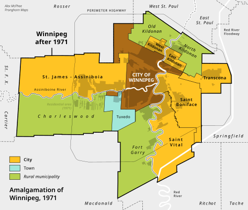


Other graphics
edit Bump chart of provincial population ranks.

Articles I am proud of
editNavboxes created/reformatted
editFirst Nations + Indigenous peoples
edit| Peoples | |
|---|---|
| Governments | |
| Languages | |
| Other | |
Alberta land-use framework regions
editNotes and subpages
edit- User:Awmcphee/Land Cover - Instructions for replicating the colourimetry used on my land cover maps.
- User:Awmcphee/Pushpin - Some thoughts on using the locator map template for community articles.
- User:Awmcphee/Maplink - Testing Template:Maplink on some Alberta municipalities. (Verdict: It only works on the largest of the bunch, and then, not accurately.)
- ↑ "List of confirmed candidates – September 20, 2021 Federal Election". Elections Canada. Retrieved 2 September 2021.