
Temnitztal is a municipality in the Ostprignitz-Ruppin district, in Brandenburg, Germany.
Temnitztal | |
|---|---|
 Medieval Tower | |
Location of Temnitztal
within Ostprignitz-Ruppin district 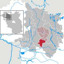 | |
 Location of Temnitztal | |
  Temnitztal  Temnitztal | |
| Coordinates: 52°52′39″N 12°37′50″E / 52.87750°N 12.63056°E | |
| Country | Germany |
| State | Brandenburg |
| District | Ostprignitz-Ruppin |
| Municipal assoc. | Temnitz |
| Subdivisions | 6 Ortsteile: Garz, Kerzlin, Küdow-Lüchfeld, Rohrlack, Vichel_(Temnitztal), Wildberg (Temnitztal) |
| Government | |
| • Mayor (2024–29) | Michael Mann[1] |
| Area | |
• Total | 51.95 km2 (20.06 sq mi) |
| Elevation | 38 m (125 ft) |
| Population (2024-12-31)[2] | |
• Total | 1,465 |
| • Density | 28.20/km2 (73.04/sq mi) |
| Time zone | UTC+01:00 (CET) |
| • Summer (DST) | UTC+02:00 (CEST) |
| Postal codes | 16845 |
| Dialling codes | 033928 |
| Vehicle registration | OPR |
| Website | |

Demography
edit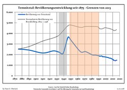
Temnitztal: Population development within the current boundaries (2013)[3] | |||||||||||||||||||||||||||||||||||||||||||||||||||||||||||||||||||||||||||||||||||||||||||||||||||||||||||||||||||||||||||||||
|
| ||||||||||||||||||||||||||||||||||||||||||||||||||||||||||||||||||||||||||||||||||||||||||||||||||||||||||||||||||||||||||||||
References
edit- ↑ Landkreis Ostprignitz-Ruppin Wahl der Bürgermeisterin / des Bürgermeisters. Retrieved 10 July 2024.
- ↑ "Bevölkerungsstand im Land Brandenburg Dezember 2024 (Fortgeschriebene amtliche Einwohnerzahlen, basierend auf dem Zensus 2023)" (XLS). Amt für Statistik Berlin-Brandenburg (in German).
- ↑ Detailed data sources are to be found in the Wikimedia Commons.Population Projection Brandenburg at Wikimedia Commons
 | This Brandenburg location article is a stub. You can help Wikipedia by adding missing information. |