Tauer (Sorbian: Turjej) is a municipality in the district of Spree-Neiße, in Lower Lusatia, Brandenburg, Germany.
Tauer
Turjej | |
|---|---|
 Coat of arms | |
Location of Tauer
within Spree-Neiße district  | |
 Location of Tauer | |
 Tauer  Tauer | |
| Coordinates: 51°54′N 14°27′E / 51.900°N 14.450°E | |
| Country | Germany |
| State | Brandenburg |
| District | Spree-Neiße |
| Municipal assoc. | Peitz |
| Government | |
| • Mayor (2024–29) | Karin Kallauke[1] |
| Area | |
• Total | 41.91 km2 (16.18 sq mi) |
| Elevation | 61 m (200 ft) |
| Population (2024-12-31)[2] | |
• Total | 682 |
| • Density | 16.3/km2 (42.1/sq mi) |
| Time zone | UTC+01:00 (CET) |
| • Summer (DST) | UTC+02:00 (CEST) |
| Postal codes | 03185 |
| Dialling codes | 035601 |
| Vehicle registration | SPN |
History
editThe area is known to have been settled as early as the Bronze Age. The first written mention was in 1632 as Tawern Tauer. In 1652, it was known as the village of Taurow.[3] From 1815 to 1947, Tauer was part of the Prussian Province of Brandenburg. From 1952 to 1990, it was part of the Bezirk Cottbus of East Germany.
Demography
edit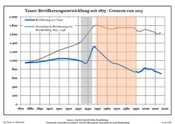
Tauer: Population development within the current boundaries (2017)[4] | ||||||||||||||||||||||||||||||||||||||||||||||||||||||||||||||||||||||||||||||||||||||||||||||||||||||||||||||||||||||||||||||||||||||
|
|
| ||||||||||||||||||||||||||||||||||||||||||||||||||||||||||||||||||||||||||||||||||||||||||||||||||||||||||||||||||||||||||||||||||||
References
edit- ↑ Landkreis Spree-Neiße Wahl der Bürgermeisterin / des Bürgermeisters. Retrieved 10 July 2024.
- ↑ "Bevölkerungsstand im Land Brandenburg Dezember 2024 (Fortgeschriebene amtliche Einwohnerzahlen, basierend auf dem Zensus 2023)" (XLS). Amt für Statistik Berlin-Brandenburg (in German).
- ↑ "Geschichtliches aus der Gemeinde Tauer". Archived from the original on 19 July 2011. Retrieved 27 February 2011.
- ↑ Detailed data sources are to be found in the Wikimedia Commons.Population Projection Brandenburg at Wikimedia Commons
External links
edit![]() Media related to Tauer at Wikimedia Commons
Media related to Tauer at Wikimedia Commons
This Brandenburg location article is a stub. You can help Wikipedia by adding missing information. |