Naugatuck (/ˈnɔːɡətʌk/; NAW-gə-tuhk) is a consolidated borough and town in New Haven County, Connecticut, United States. The town, part of the Naugatuck Valley Planning Region, had a population of 31,519 as of the 2020 census.[2]
Naugatuck, Connecticut | |
|---|---|
 Naugatuck Green | |
 Seal | |
| Nickname: "Naugy" | |
  | |
   | |
| Coordinates: 41°29′23″N 73°03′05″W / 41.48972°N 73.05139°W | |
| Country | |
| U.S. state | |
| County | New Haven |
| Region | Naugatuck Valley |
| Incorporated | 1844 |
| Consolidated | 1895 |
| Government | |
| • Type | Mayor–council (mayor and burgesses) |
| • Mayor | N. Warren "Pete" Hess |
| Area | |
• Total | 16.39 sq mi (42.46 km2) |
| • Land | 16.30 sq mi (42.21 km2) |
| • Water | 0.097 sq mi (0.25 km2) |
| Elevation | 207 ft (63 m) |
| Population (2020) | |
• Total | 31,519 |
| • Density | 1,934/sq mi (746.7/km2) |
| Time zone | UTC−5 (Eastern) |
| • Summer (DST) | UTC−4 (Eastern) |
| ZIP code | 06770 |
| Area codes | 203/475 |
| FIPS code | 09-49880 |
| GNIS feature ID | 0209191 |
| Website | www |
The town spans both sides of the Naugatuck River just south of Waterbury and includes the communities of Union City on the east side of the river, Straitsville on the southeast (along Route 63), and Millville on the west (along Rubber Avenue).
Etymology
editThe town has been named after Naugatuck River. Along the path of the river, various Algonquian bands, often included in the Wappinger tribe, originally inhabited the Naugatuck River Valley. Thus the name "Naugatuck" is derived from a term from the local Algonquian dialect meaning "lone tree by the fishing place". One early 19th-century author explained that this name originally referred to a specific tree along the river in the area of modern-day Beacon Falls,[3] but came to be applied broadly to the entire river over time.[4]
History
editSettlement began as early as 1702. Samuel Hickox (1669–1713), credited as Naugatuck’s first settler, established a fulling mill on Fulling Mill Brook in 1709. The locality was known as Judds Meadow until 1752, when it was renamed Salem Bridge.[5][6]
In 1844, parts of Waterbury, Bethany, and Oxford incorporated as the town of Naugatuck. The Borough of Naugatuck was established in 1893 and became coextensive with the town in 1895.[7]
As the Industrial Revolution accelerated, Naugatuck developed a diverse manufacturing base and became a center of the rubber industry. In 1892, nine firms consolidated to form the United States Rubber Company (later Uniroyal Inc.), organized in Naugatuck, which for decades kept major operations in the borough.[8] In 1936, U.S. Rubber introduced Naugahyde, a vinyl-coated fabric invented by company chemists in Naugatuck; the material was manufactured locally for many years.[9]


The United States Rubber Company also created the Naugatuck Chemical Company in the early 20th century; the business later became Uniroyal Chemical and relocated major operations to Middlebury, Connecticut in the 1970s.[10]
The Risdon Manufacturing Company, established in Naugatuck in the early 1900s, became a leading maker of metal closures and cosmetic packaging and later operated regionally under Crown Risdon.[11]
In the 1960s, Harold Barber founded H. Barber and Sons, which designs and builds beach-cleaning equipment and has claimed to be the largest such business in the world.[12]
Peter Paul Candy Manufacturing Company, later a division of the Hershey Foods Corporation producing Almond Joy and Mounds, operated in Naugatuck for much of the 20th century; the factory closed in 2007.[13]
On August 19, 1955, the Naugatuck River flooded following more than 10 inches (250 mm) of rain from Hurricane Diane, causing widespread destruction that reshaped the borough’s riverfront.[14]
Naugatuck High School has a long-standing football rivalry with Ansonia. The teams have met on Thanksgiving morning since 1900, with Ansonia holding the series lead. Naugatuck High School’s mascot is the greyhound, and its colors are garnet and gray.
Geography
editAccording to the United States Census Bureau, the borough has a total area of 16.5 square miles (43 km2), of which 16.4 square miles (42 km2) is land and 0.1 square miles (0.26 km2), or 0.36%, is water.[1]
Demographics
edit| Census | Pop. | Note | %± |
|---|---|---|---|
| 1850 | 1,720 | — | |
| 1860 | 2,590 | 50.6% | |
| 1870 | 2,830 | 9.3% | |
| 1880 | 4,274 | 51.0% | |
| 1890 | 6,218 | 45.5% | |
| 1900 | 10,541 | 69.5% | |
| 1910 | 12,722 | 20.7% | |
| 1920 | 15,051 | 18.3% | |
| 1930 | 14,315 | −4.9% | |
| 1940 | 15,388 | 7.5% | |
| 1950 | 17,455 | 13.4% | |
| 1960 | 19,511 | 11.8% | |
| 1970 | 23,034 | 18.1% | |
| 1980 | 26,456 | 14.9% | |
| 1990 | 30,625 | 15.8% | |
| 2000 | 30,989 | 1.2% | |
| 2010 | 31,862 | 2.8% | |
| 2020 | 31,519 | −1.1% | |
| 2025 (est.) | 32,230 | [15] | 2.3% |
| U.S. Decennial Census[16] | |||
2020 census
editAs of the 2020 census, there were 31,519 people, 12,432 households, and 13,239 housing units in the borough.[17] The population density was 1,933.8 inhabitants per square mile (746.6/km2), and the average housing-unit density was 812.2 per square mile (313.6/km2).[18] The racial makeup of the borough was 71.4% White, 7.8% Black or African American, 0.2% American Indian and Alaska Native, 2.4% Asian, 0.1% Native Hawaiian and Other Pacific Islander, 7.4% from some other race, and 10.8% from two or more races. Hispanic or Latino residents of any race were 15.5% of the population.[19]
Of the 12,432 households, 30.2% included children under the age of 18, 45.1% were married-couple households, 8.3% were cohabiting-couple households, 18.2% had a male householder with no spouse or partner present, and 28.4% had a female householder with no spouse or partner present. About 26.9% of households consisted of a single individual, and 11.3% had someone 65 years of age or older living alone.[17]
In 2020, 21.1% of Naugatuck residents were under the age of 18, 62.8% were between 18 and 64, and 16.1% were 65 or older; the median age was 40.2 years. Males made up 48.7% of the population and females 51.3%.[17]
2020–2024 American Community Survey
editAccording to the American Community Survey 5-year estimates for 2020–2024, the median household income in Naugatuck was $96,324 and the per capita income was $44,375.[20] About 6.3% of all individuals had incomes below the poverty line.[20] Among residents aged 25 and older, 91.0% held at least a high school diploma and 32.2% held a bachelor's degree or higher.[21] An estimated 17.3% of residents were foreign-born, and the borough was home to approximately 1,086 military veterans, or 4.3% of the civilian population aged 18 and over.[21] The median value of owner-occupied housing units was $259,100.[22]
Government
editNaugatuck is the only consolidated town and borough in Connecticut. Every other borough in the state is a special-services district located within a town, the basic unit of Connecticut local government. Naugatuck has both a town clerk and a borough clerk managing official records, similar to cities that have separate town and city clerks.
As with most other Connecticut municipalities, Naugatuck elects its officials in November of odd-numbered years.
Politics
editRegistration and Party Enrollment Statistics | ||||||||||||||||||||||||||||||||||||||||||
|---|---|---|---|---|---|---|---|---|---|---|---|---|---|---|---|---|---|---|---|---|---|---|---|---|---|---|---|---|---|---|---|---|---|---|---|---|---|---|---|---|---|---|
| ||||||||||||||||||||||||||||||||||||||||||
United States presidential election results | ||||||||||||||||||||||||||||||||||||||||||||||||||||||||||||||||||||||||||||||||||||||||||||||||||||||||||||||||||||||||||||||||||||||||||||||||||||||||||||||||||||||||||||||||||||||||||||||||||||||||||||||||||||||||||||||||||||||||||||||||||||||||||||||||||||||||||||||||||||||||||||||||||||||||||||||||||||||||||||||||||||||||
|---|---|---|---|---|---|---|---|---|---|---|---|---|---|---|---|---|---|---|---|---|---|---|---|---|---|---|---|---|---|---|---|---|---|---|---|---|---|---|---|---|---|---|---|---|---|---|---|---|---|---|---|---|---|---|---|---|---|---|---|---|---|---|---|---|---|---|---|---|---|---|---|---|---|---|---|---|---|---|---|---|---|---|---|---|---|---|---|---|---|---|---|---|---|---|---|---|---|---|---|---|---|---|---|---|---|---|---|---|---|---|---|---|---|---|---|---|---|---|---|---|---|---|---|---|---|---|---|---|---|---|---|---|---|---|---|---|---|---|---|---|---|---|---|---|---|---|---|---|---|---|---|---|---|---|---|---|---|---|---|---|---|---|---|---|---|---|---|---|---|---|---|---|---|---|---|---|---|---|---|---|---|---|---|---|---|---|---|---|---|---|---|---|---|---|---|---|---|---|---|---|---|---|---|---|---|---|---|---|---|---|---|---|---|---|---|---|---|---|---|---|---|---|---|---|---|---|---|---|---|---|---|---|---|---|---|---|---|---|---|---|---|---|---|---|---|---|---|---|---|---|---|---|---|---|---|---|---|---|---|---|---|---|---|---|---|---|---|---|---|---|---|---|---|---|---|---|---|---|---|---|---|---|---|---|---|---|---|---|---|---|---|---|---|---|---|---|---|---|---|---|---|---|---|---|---|---|---|---|---|---|---|---|---|---|---|---|---|---|---|---|---|---|---|---|---|---|---|---|
Notes: 1912 – Third-party total 785 comprised Progressive 274, Socialist 456, and other 55. · 1872 – Votes for Horace Greeley (Liberal Republican), also endorsed by Democrats, are recorded under Third party(ies). · 1860 – “Third-party” votes were for the Southern Democratic ticket. | ||||||||||||||||||||||||||||||||||||||||||||||||||||||||||||||||||||||||||||||||||||||||||||||||||||||||||||||||||||||||||||||||||||||||||||||||||||||||||||||||||||||||||||||||||||||||||||||||||||||||||||||||||||||||||||||||||||||||||||||||||||||||||||||||||||||||||||||||||||||||||||||||||||||||||||||||||||||||||||||||||||||||
Education
editNaugatuck has four public elementary schools (grades K–4), two public intermediate schools (grades 5–6), one public middle school (grades 7–8), and Naugatuck High School (grades 9–12). The high school’s total enrollment is 1,267.
In 2013, an $81 million renovation of the high school began and was completed by fall 2015.[26]
Transportation
editThe town is served by Naugatuck station on the Waterbury Branch of the New Haven Line. Principal highways include Connecticut Route 63 (to New Haven), Route 68 (to Durham), and the Route 8 expressway (to Waterbury, Derby, Torrington, and Bridgeport).
National Register of Historic Places
edit- Bronson B. Tuttle House (380 Church Street), an 1879 Queen Anne–style residence that now houses the Naugatuck History Museum; listed on the National Register on November 29, 1990.[27][28]
- Naugatuck Center Historic District, roughly bounded by Fairview Avenue, Hillside Avenue, Terrace Avenue, Water Street, and Pleasant View Street; listed July 30, 1999.[29]
- Salem School (124 Meadow Street); listed November 3, 1983.[30]
- United States Post Office–Naugatuck Main (Church and Cedar Streets.); listed January 21, 1986.[31]
Notable people
edit- Adrian (Adrian Adolph Greenberg), costume designer; born in Naugatuck[32]
- Michael Bergin, model and actor; raised in Naugatuck and NHS graduate[33][34]
- Seth Bingham, organist and composer; spent part of his youth in Naugatuck[35]
- Emily Sophie Brown, among the first women elected to the Connecticut House of Representatives; longtime Naugatuck resident[36]
- Harry Cross (1881–1946), sportswriter for The New York Times and the New York Herald Tribune; began his career at the Waterbury American; mentioned among notable Naugatuck students in a borough history.[37][38][39]
- Ray Foley, Major League Baseball catcher (New York Giants, 1928); born in Naugatuck[40]
- Charles Goodyear, pioneered vulcanization of rubber; lived in Naugatuck as a young man[41]
- Mohamed Hrezi, distance runner; 2016 Olympic marathoner[42]
- William Kennedy (1854–1918), state senator and U.S. representative[43]
- Ronald A. Sarasin (1934–2023), U.S. Representative for Connecticut’s 5th district (1973–1979) and 1978 Republican nominee for governor; later president/CEO of the U.S. Capitol Historical Society; graduated from Naugatuck High School (Class of 1952).[44][45][46][47]
- Spec Shea, Major League Baseball pitcher; born in Naugatuck and nicknamed “The Naugatuck Nugget”[48]
Gallery
edit Goodyear Metallic Rubber Shoe Company in downtown Naugatuck (c. 1890)
 Salem School, from a 1905 postcard
 Naugatuck High School (c. 1910), designed by McKim, Mead & White; now Hillside Intermediate School
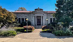 Whittemore Library, designed by McKim, Mead & White
 Town history sign on the Naugatuck Green


See also
editReferences
edit- 1 2 "2019 U.S. Gazetteer Files – Places: Connecticut". United States Census Bureau. 2019. Retrieved July 2, 2020.
- ↑ "Census — Geography Profile: Naugatuck borough, Connecticut". United States Census Bureau. Retrieved December 18, 2021.
- ↑ Orcutt, Samuel (1882). The Indians of the Housatonic and Naugatuck Valleys. Press of the Case, Lockwood & Brainard Company. pp. 62–63. Retrieved March 24, 2016.
- ↑ Hughes, Arthur H.; Morse, Shepard Allen (1976). Connecticut Place Names. Hartford, Connecticut: The Connecticut Historical Society. p. 627. ISBN 9780940748064.
- ↑ "Early Settlement & Founders". Naugatuck Historical Society. Retrieved September 14, 2025.
- ↑ "Naming & Incorporation". Naugatuck Historical Society. Retrieved September 14, 2025.
- ↑ "Naming & Incorporation". Naugatuck Historical Society. Retrieved September 14, 2025.
- ↑ "U.S. Rubber Company – Company History: Our Legacy Since 1892". U.S. Rubber Company. Retrieved September 14, 2025.
- ↑ "Naugahyde: A Naugatuck Original". ConnecticutHistory.org. Connecticut Humanities. January 5, 2015. Retrieved September 14, 2025.
- ↑ "Uniroyal Chemical Company records". Archives & Special Collections, University of Connecticut Library. Retrieved September 14, 2025.
- ↑ "The Emhart Story (packaging history)" (PDF). Emhart. Retrieved September 14, 2025.
- ↑ "Company history". H. Barber & Sons. Retrieved September 14, 2025.
- ↑ Podsada, Janice (April 26, 2007). "A Not-So-Sweet Ending in Naugatuck". Hartford Courant. Archived from the original on September 12, 2025. Retrieved September 12, 2025.
- ↑ "The Flood of 1955". Naugatuck Historical Society. Retrieved September 14, 2025.
- ↑ "QuickFacts: Naugatuck borough, Connecticut". United States Census Bureau. Retrieved May 15, 2026.
- ↑ "Census of Population and Housing". United States Census Bureau. Retrieved April 17, 2026.
- 1 2 3 "DP1: Profile of General Population and Housing Characteristics – 2020 Decennial Census, Naugatuck borough, Connecticut". United States Census Bureau. Retrieved April 17, 2026.
- ↑ "H1: Occupancy Status – 2020 Decennial Census Redistricting Data (PL 94-171), Naugatuck borough, Connecticut". United States Census Bureau. Retrieved April 17, 2026.
- ↑ "P2: Hispanic or Latino, and Not Hispanic or Latino by Race – 2020 Decennial Census Redistricting Data (PL 94-171), Naugatuck borough, Connecticut". United States Census Bureau. Retrieved April 17, 2026.
- 1 2 "DP03: Selected Economic Characteristics – 2020–2024 American Community Survey 5-Year Estimates, Naugatuck borough, Connecticut". United States Census Bureau. Retrieved April 17, 2026.
- 1 2 "DP02: Selected Social Characteristics in the United States – 2020–2024 American Community Survey 5-Year Estimates, Naugatuck borough, Connecticut". United States Census Bureau. Retrieved April 17, 2026.
- ↑ "DP04: Selected Housing Characteristics – 2020–2024 American Community Survey 5-Year Estimates, Naugatuck borough, Connecticut". United States Census Bureau. Retrieved April 17, 2026.
- ↑ "Registration and Party Enrollment Statistics as of October 17, 2025" (PDF). Connecticut Secretary of State. Archived (PDF) from the original on November 23, 2025. Retrieved November 23, 2025.
- ↑ "State of Connecticut Elections Database". State of Connecticut Elections Database. Connecticut Secretary of the State. Retrieved September 12, 2025.
- ↑ "General Election Statements of Vote, 1922–Current". CT Secretary of State. Retrieved May 16, 2020.
- ↑ "NHS renovations moving ahead full steam". Citizen's News. July 23, 2013. Retrieved October 19, 2016.
- ↑ "NPGallery Asset Detail: Bronson B. Tuttle House". National Register of Historic Places. National Park Service. Retrieved September 14, 2025.
- ↑ "The Naugatuck History Museum at the Tuttle House". Naugatuck Historical Society. Retrieved September 14, 2025.
- ↑ "NPGallery Asset Detail: Naugatuck Center Historic District". National Register of Historic Places. National Park Service. Retrieved September 14, 2025.
- ↑ "NPGallery Asset Detail: Salem School". National Register of Historic Places. National Park Service. Retrieved September 14, 2025.
- ↑ "NPGallery Asset Detail: U.S. Post Office—Naugatuck Main". National Register of Historic Places. National Park Service. Retrieved September 14, 2025.
- ↑ "Adrian". Encyclopaedia Britannica. Retrieved September 14, 2025.
- ↑ "Hawaii next stop in the career of Michael Bergin". Honolulu Star-Bulletin. September 24, 2004. Retrieved September 14, 2025.
- ↑ "Michael Bergin '86". Naugatuck High School. Retrieved September 14, 2025.
- ↑ "Seth Bingham (1882–1972)". Encyclopaedia Britannica. Retrieved September 14, 2025.
- ↑ "Profile: Emily Sophie Brown". League of Women Voters of Connecticut. Retrieved September 14, 2025.
- ↑ Green, Edward K. (1948). History of Naugatuck, Connecticut. New Haven Colony Historical Society. Retrieved September 14, 2025.
- ↑ "Harry Cross, Sports Writer, Dies at 64". The New York Times. April 4, 1946. p. 23.
- ↑ "Harry Cross to the Evening Post". Naugatuck Daily News. July 8, 1913. p. 1.
- ↑ "Ray Foley". Baseball-Reference.com. Retrieved September 14, 2025.
- ↑ Slack, Charles (2002). Noble Obsession: Charles Goodyear, Thomas Hancock, and the Race to Unlock the Greatest Industrial Secret of the Nineteenth Century. New York: Hyperion. ISBN 978-0786867899.
- ↑ "Rio 2016 – Athletes: Mohamed Hrezi". International Olympic Committee. Retrieved September 14, 2025.
- ↑ "Kennedy, William". Biographical Directory of the United States Congress. Retrieved February 1, 2025.
- ↑ Dixon, Ken (April 7, 2023). "Ronald Sarasin, three-term CT congressman, dies at 88". CT Insider. Retrieved September 14, 2025.
- ↑ "Obituary: The Honorable Ronald Arthur Sarasin, 88". Naugatuck Patch. April 10, 2023. Retrieved September 14, 2025.
- ↑ "SARASIN, Ronald Arthur". Biographical Directory of the United States Congress. Retrieved September 14, 2025.
- ↑ "Remembering Ronald A. Sarasin". United States Capitol Historical Society. March 27, 2023. Retrieved September 14, 2025.
- ↑ "Spec Shea Statistics and History". Baseball-Reference.com. Retrieved September 14, 2025.