Moulsoe is a village and civil parish in the unitary authority area of the City of Milton Keynes, Buckinghamshire, England.[2] It is on the border with Bedfordshire, and just east of the M1, situated about 2.5 miles (4.0 km) ESE of Newport Pagnell, and about 5 miles (8.0 km) NNE of Central Milton Keynes. The main road through the village is the Newport Road coming from the west, changing to the Cranfield Road going east at a bend by the church.
| Moulsoe | |
|---|---|
 The Parish Church - St Mary's of the Assumption | |
 Moulsoe Location within Buckinghamshire | |
 Interactive map of Moulsoe | |
| Population | 332 (2021 census)[1] |
| OS grid reference | SP910419 |
| Civil parish |
|
| District | |
| Unitary authority | |
| Ceremonial county | |
| Region | |
| Country | England |
| Sovereign state | United Kingdom |
| Post town | NEWPORT PAGNELL |
| Postcode district | MK16 |
| Dialling code | 01908 |
| Police | Thames Valley |
| Fire | Buckinghamshire |
| Ambulance | South Central |
| UK Parliament | |
The village name is an Old English language word which means 'Mul's hill spur'.[3] In the Domesday Book of 1086 the village was recorded as Moleshou.[4]
There are several old thatched dwellings. Other buildings are of brick apart from some concrete council houses to the west. The parish church dates from the 14th century and is a Grade I listed building.[5] There is an inn, the Carrington Arms, and a village hall, the Millennium Hall.[6]
Caldecote
editCaldecote (52°04′23″N 0°42′54″W / 52.073°N 0.715°W} is a tiny hamlet off Willen Raod at the northeast corner of the parish, notable because of it being mentioned in Domesday because it had two watermills.[7]
Milton Keynes East
editMilton Keynes East (also MK East) is a substantial new development at the northern end of the parish, with strategic development approval for 5,000 houses and 105 hectares (260 acres) for employment.[8]
Gallery
edit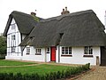 Yew Tree Cottage, Newport Road
 The Carrington Arms, Cranfield Road
 St Mary's church, view from Newport Road


See also
edit- Adjacent parishes
- Newport Pagnell
- North Crawley
- Cranfield (Bedfordshire)
- Broughton and Milton Keynes
- Great Linford
- Hulcote and Salford (Bedfordshire)
References
edit- ↑ "PP012 - Age". NOMIS (Office for National Statisitcs., then select Milton Keynes, then this parish
- ↑ "Contact your Parish, Town or Community Council". Milton Keynes Council. Retrieved 10 October 2020.
- ↑ "Key to English place names". Institute for Name-Studies, University of Nottingham. Retrieved 15 November 2025.
- ↑ moulsoe.net/history.htm
- ↑ Historic England (17 November 1966). "Church of St. Mary (1212922)". National Heritage List for England. Retrieved 15 November 2025.
- ↑ www.milton-keynes.gov.uk Deprecated link archived 2012-12-23 at archive.today Moulsoe Millennium Hall
- ↑ "Buckinghamshire A-E". The Domesday Book Online. Retrieved 23 November 2022.
- ↑ Milton Keynes City Council (March 2020). "Milton Keynes East | Strategic Urban Extension Development Framework | Supplementary Planning Document" (PDF).
External links
edit![]() Media related to Moulsoe at Wikimedia Commons
Media related to Moulsoe at Wikimedia Commons
- Moulsoe on Ordnance Survey (1901). "Buckinghamshire Sheet XX.2" (Map). OS 25-inch England and Wales, 1842-1952. 1:2,500. Ordnance Survey – via National Library of Scotland.
- Caldecote on Ordnance Survey (1925). "Buckinghamshire Sheet X.6" (Map). OS 25-inch England and Wales, 1842-1952. 1:2,500. Ordnance Survey – via National Library of Scotland.
This Buckinghamshire location article is a stub. You can help Wikipedia by adding missing information. |