Llanddona fish weir (also known as Welsh: Gorad Llanddona or Welsh: Gorad Fona) is a post-medieval fish trap sited in Llanddona, on the Isle of Anglesey. The fish weir is a scheduled monument.
| Llanddona fish weir | |
|---|---|
| Gorad Llanddona | |
 Red Wharf Bay with fish weir in the distance | |
 Location in Anglesey | |
| 53°18′29″N 4°08′38″W / 53.308°N 4.144°W | |
| Type | fish weir |
| Location | Anglesey, Wales |
| SH 5725 8116 | |
Official name | Llanddona Fish Weir |
| Designated | 31 October 2002 |
| Reference no. | AN137 |
Location
editLlanddona fish weir is at the far eastern end of the beach at Red Wharf Bay where a band of rocks turns to sand, and is near the estuary of the brook that passes near St Dona's church.[1][2][3] The fish weir lies at the edge of the Penmon Historic Landscape Area.[4]
Description
editLlanddona fish weir is a V-shaped trap, typically used when trapping fish in tidal waters.[5][6] The two arms of the V run down the beach, starting below the high-water line and almost meet at the tip of the V just above the low-water line, where the fish are caught in a net or a trap when the tide recedes.[7] The sides of the V-shaped trap can be made of stone, wattle fencing, or both.[7]
At Llanddona the sea is north of the beach, so the western arm, about 300m long, points north-east, and the eastern arm, about 100m long, starts at the edge of the beach and points north-west.[3][2]
History
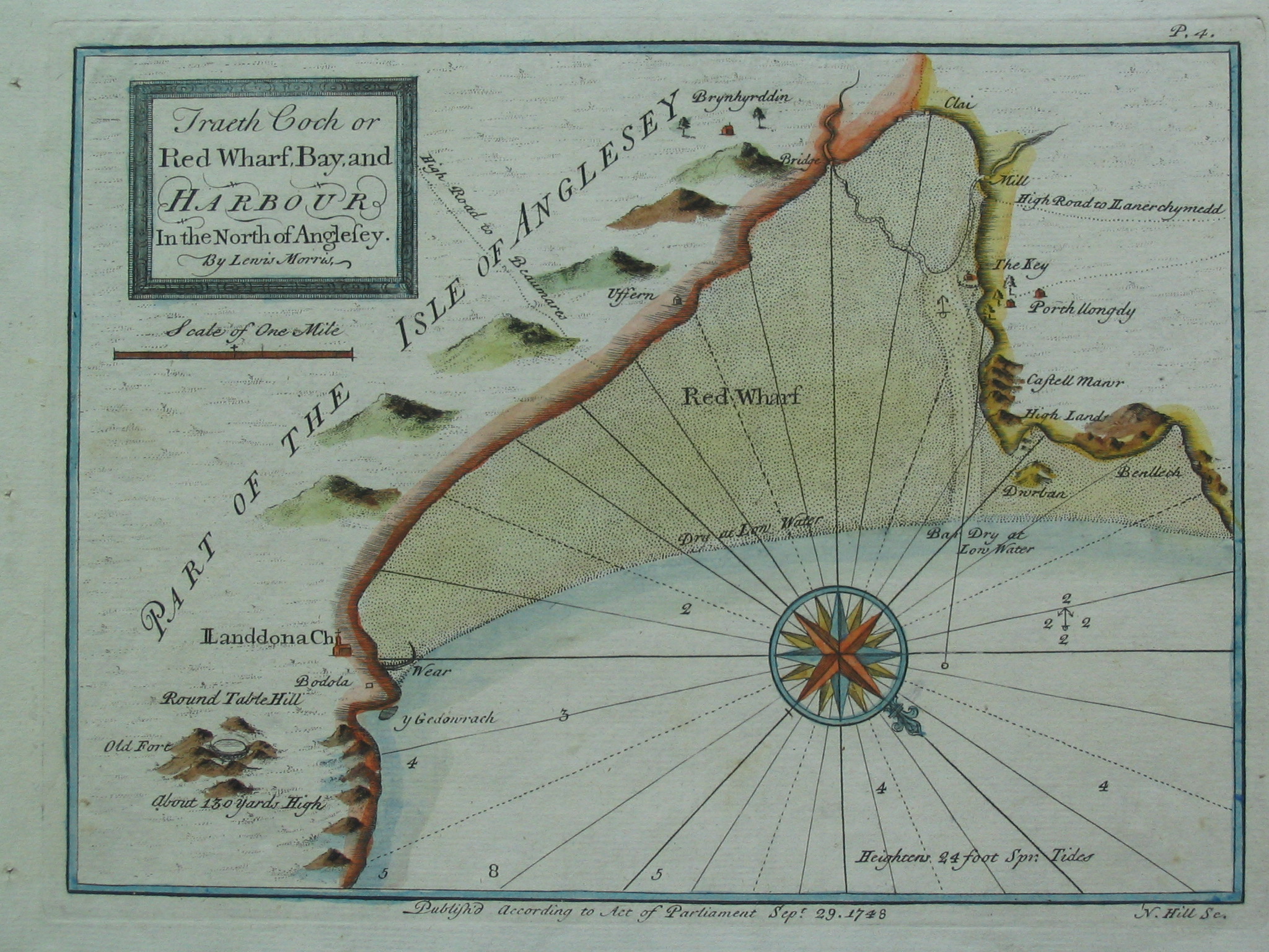
editLlanddona fish weir is first mentioned in the 17th century in the records of the Baron Hill estate and is also shown on a chart of 1748 by Lewis Morris, a hydrographer, surveyor and author from Anglesey.[6][1][8]
Near the weir there are two buildings named as Godreddi Bach and Godreddi Mawr. The names seem to be a corruption of Goreddi (the plural of gored, meaning weir).[9] This possibly associates the buildings with the weir, and that there may have been more than one weir.[9] Additionally, a double line of stones has been identified on an aerial photograph which may be part of the original construction or part of later rebuilding.[1]
Recent history
editLlanddona fish weir was designated as a scheduled monument in 2002 as being of national importance to improve understanding of medieval or post-medieval maritime agricultural practices and possibly containing archaeological information concerning chronology and building techniques.[6]
Access
editSee also
editReferences
edit- 1 2 3 Llanddona (Report). Gwynedd Archaeological Trust (GAT). GAT PRN 33476. Archived from the original on 24 September 2015. Retrieved 29 July 2016.
- 1 2 Anglesey Sheet XIV.NE (Map) (1st ed.). 1:10560. Ordnance Survey. 1888. Retrieved 29 July 2016 – via National Library of Scotland.
- 1 2 3 "Llanddona Fish Trap (406349)". Coflein. RCAHMW. Retrieved 30 September 2021.
- ↑ "Penmon Historic Landscapes". Gwynedd Archaeological Trust (GAT). 2010. Archived from the original on 5 August 2016. Retrieved 29 July 2016.
- ↑ Fish Trap, Llandona (ID PRN7204). in the 'SMR' for Gwynedd Archaeological Trust (GAT). Retrieved 30 September 2021
- 1 2 3 Llanddona Fish Weir. National Monuments Record of Wales (NMRW) (Report). Cadw. 31 October 2002 [Scheduled 2002]. Cadw Id: AN137.
- 1 2 Bannerman, N. V. Campbell (2011). Flood, Folklore and Fish Weirs (PDF) (Report). p. 3. Retrieved 30 July 2016.
- ↑ Wiliam, Dafydd Wyn. "Morris, Lewis". Oxford Dictionary of National Biography (online ed.). Oxford University Press. doi:10.1093/ref:odnb/19313. (Subscription, Wikipedia Library access or UK public library membership required.)
- 1 2 Vousden, Nikola (2014). The Archaeological and Historical Significance of Intertidal Fish Traps at Llanon, Cardigan Bay (Report). Lampeter: University of Wales Trinity Saint David. pp. 32–33. CiteSeerX 10.1.1.655.3206.
- ↑ "Circular walk – Llanddona" (PDF). www.visitanglesey.co.uk. Isle of Anglesey County Council. Retrieved 1 August 2016.
External links
edit- Llanddona Fish Weir – on Ancient Monuments website
- Lewis Morris's Map of Red Wharf Bay, 1748 – from a collection at Liverpool University