42°50′N 24°50′E / 42.833°N 24.833°E
Laki Municipality
Община Лъки | |
|---|---|
 Flag | |
.png) | |
| Country | |
| Province | Plovdiv Province |
| Seat | Laki |
| Area | |
• Total | 292.5 km2 (112.9 sq mi) |
| Population (2024) | |
• Total | 2,043[1] |
| • Density | 6.985/km2 (18.09/sq mi) |
| Website | www |
Laki Municipality (Bulgarian: Община Лъки) is a municipality in the south of Plovdiv Province, central Bulgaria. Covering a territory of 292.5 km2, it is the tenth largest of the 18 municipalities in the province, encompassing 4.88% of its total area. It borders the municipalities of Asenovgrad to the north and northeast, Banite to the east and southeast, Smolyan to the south, and Chepelare to the west. All of them but Asenovgrad are part of the neighbouring Smolyan Province.[2]
The municipal seat Laki is located 54 km south of the regional center Plovdiv, 36 km south of the town of Asenovgrad, and 88 km north of the town of Smolyan.[2]
Geography
editThe topography consists of medium and high-altitude mountain elevations. The whole municipal area lies within the northern slopes of the Rhodope Mountains. To the south and southeast spans the middle portion of the Perelik–Prespa division of the mountain range, where its highest point, the summit of Prespa (2,000 m) is located. There are several more ridges separated by the deep valleys of the rivers systems. To the north, in the valley of the river Chepelarska reka is the lowest point of the municipality at 435 m. The average altitude is 850 m.[3]
Laki Municipality falls within the transitional continental climatic zone with strong mountainous influence. In its northernmost part flows a 5 km section of the Chepelarska reka, a right tributary of the Maritsa of the Aegean Sea basin. Almost all of its territory is drained by the Chepelarska’s right tributary the Yugovska reka and its constituting rivers the Sushitsa, the Belishka reka, and others.[3]
Transport
editDemography
editGallery
edit
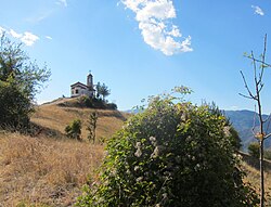 A chapel near Borovo
 A view of Laki


Citations
edit- 1 2 "Tables of Persons Registered by Permanent Address and by Current Address". Official Site of the Civil Registration and Administrative Services (GRAO). Retrieved 8 May 2026.
- 1 2 "About Laki Municipality". Official Site of Laki Municipality. Retrieved 8 May 2026.
- 1 2 "Natural Characteristics". Official Site of Laki Municipality. Retrieved 8 May 2026.
- ↑ "A Map of the Republican Road Network of Bulgaria". Official Site of the Road Infrastructure Agency. Retrieved 8 May 2026.
- ↑ "Technical Infrastructure". Official Site of Laki Municipality. Retrieved 8 May 2026.
- ↑ "Settlements and Landmarks". Official Site of Laki Municipality. Retrieved 8 May 2026.
References
edit- Мичев (Michev), Николай (Nikolay); Михайлов (Mihaylov), Цветко (Tsvetko); Вапцаров (Vaptsarov), Иван (Ivan); Кираджиев (Kiradzhiev), Светлин (Svetlin) (1980). Географски речник на България [Geographic Dictionary of Bulgaria] (in Bulgarian). София (Sofia): Наука и култура (Nauka i kultura).