
Kaltern an der Weinstraße (Austrian German: [ˈkaltɐn an deːɐ̯ ˈvaɪnˌʃtraːsɛ]; Italian: Caldaro sulla Strada del Vino [kalˈdaːro sulla ˈstraːda del ˈviːno]), often abbreviated to Kaltern or Caldaro, is a municipality and a village in South Tyrol in northern Italy. It is about 12 kilometres (7 mi) southwest of the city of Bolzano.
Kaltern an der Weinstraße | |
|---|---|
| Marktgemeinde Kaltern an der Weinstraße Comune di Caldaro sulla Strada del Vino | |
 General view of Kaltern's Marktplatz ("market square") | |
 Coat of arms | |
 The municipal area | |
  Kaltern an der Weinstraße Location of Kaltern an der Weinstraße in Italy  Kaltern an der Weinstraße Kaltern an der Weinstraße (Trentino-Alto Adige/Südtirol) | |
| Coordinates: 46°25′N 11°15′E / 46.417°N 11.250°E | |
| Country | Italy |
| Region | Trentino-Alto Adige/Südtirol |
| Province | South Tyrol (BZ) |
| Frazioni | Altenburg (Castelvecchio), Oberplanitzing (Pianizza di Sopra), Unterplanitzing (Pianizza di Sotto), St. Josef am See (San Giuseppe al Lago), St. Anton/Pfuss (San Antonio/Pozzo), St. Nikolaus (San Nicoló) and Mitterdorf (Villa di Mezzo) |
| Government | |
| • Mayor | Christoph Pillon (Südtiroler Volkspartei) |
| Area | |
• Total | 47.9 km2 (18.5 sq mi) |
| Elevation | 425 m (1,394 ft) |
| Population (Nov. 2010)[2] | |
• Total | 7,592 |
| • Density | 158/km2 (411/sq mi) |
| Demonym(s) | German: Kalterer Italian: caldaresi |
| Time zone | UTC+1 (CET) |
| • Summer (DST) | UTC+2 (CEST) |
| Postal code | 39052 |
| Dialing code | 0471 |
| Website | Official website |
Geography
editAs of 30 November 2010, it had a population of 7,592 and an area of 47.9 square kilometres (18.5 mi2).[3]
It is famous for its lake, the Kalterer See, and wine (Kalterersee Auslese or Lago di Caldaro scelto). The cuisine combines Italian and Tyrolean styles. The nearby Dolomites area is known for its hiking and climbing routes.
Kaltern borders the following municipalities: Eppan, Neumarkt, Tramin, Vadena, Amblar, Cavareno, Ruffrè-Mendola, and Sarnonico (the last four municipalities belong to the Trentino).
Frazioni
editThe municipality of Kaltern contains the frazioni (subdivisions, mainly villages and hamlets) Altenburg (Castelvecchio), Oberplanitzing (Pianizza di Sopra), Unterplanitzing (Pianizza di Sotto), St. Josef am See (San Giuseppe al Lago), St. Anton/Pfuss (San Antonio/Pozzo), St. Nikolaus (San Nicoló) and Mitterdorf (Villa di Mezzo).
History
editSociety
editLinguistic distribution
editDemographic evolution
editHistorical population | |||||||||||||||||||||||||||||||||||||||||||||||||||||
|
|
| |||||||||||||||||||||||||||||||||||||||||||||||||||
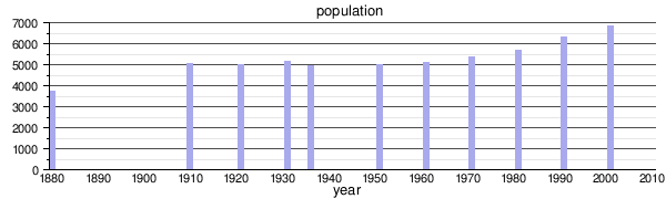 | |||||||||||||||||||||||||||||||||||||||||||||||||||||
| Source: Data from ISTAT & ASTAT | |||||||||||||||||||||||||||||||||||||||||||||||||||||
Twin towns
editKaltern an der Weinstraße is twinned with:
 Heppenheim, Germany (1971)
Notable residents
edit- Manfred Fuchs (1938 in Latsch – 2014 in Kaltern) a German entrepreneur and space pioneer
- Andreas Seppi (born 1984) an Italian professional tennis player
Picture gallery
edit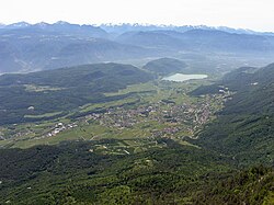 Panorama of Kaltern from the Penegal
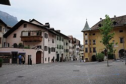 Kaltern, town center
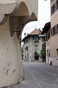 Kaltern, town center
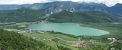 The Kalterer See (lake of Kaltern)


References
edit- ↑ "Superficie di Comuni Province e Regioni italiane al 9 ottobre 2011". Italian National Institute of Statistics. Retrieved 16 March 2019.
- ↑ "Popolazione Residente al 1° Gennaio 2018". Italian National Institute of Statistics. Retrieved 16 March 2019.
- ↑ All demographics and other statistics: Italian statistical institute Istat.
- ↑ Heraldry of the World: Kaltern
- ↑ "Ergebnisse Sprachgruppenzählung 2024/Risultati Censimento linguistico 2024". astat info (56). Provincial Statistics Institute of the Autonomous Province of South Tyrol. December 2024. Retrieved 2024-12-09.
External links
edit- (in German and Italian) Homepage of the municipality
 Media related to Kaltern an der Weinstraße at Wikimedia Commons