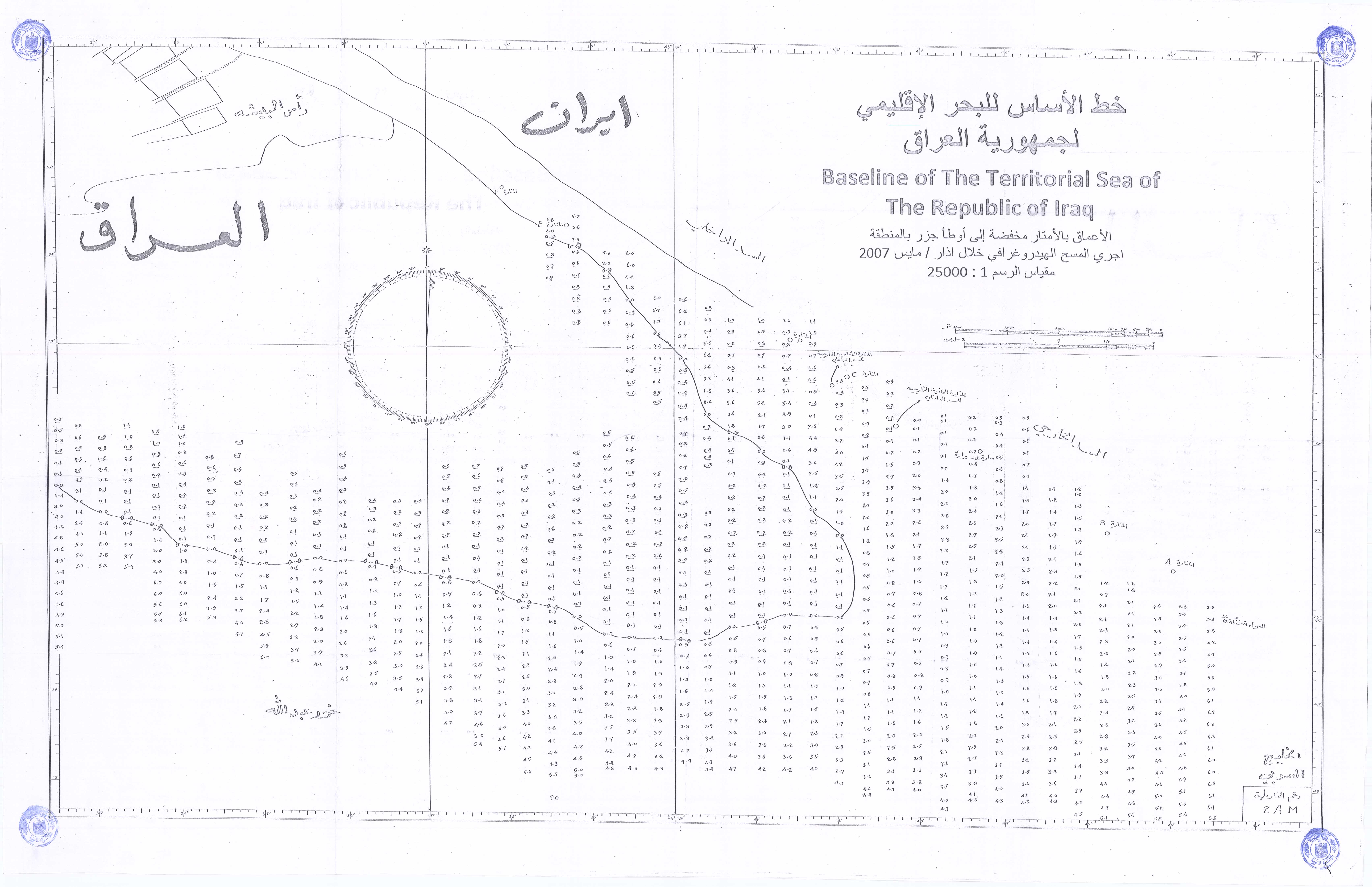
The Iraqi Territorial Sea (Arabic: البحر الإقليمي العراقي, romanized: al-Bahr al-Iqlimi al-Iraqi) refers to the maritime baseline and territorial waters under the sovereignty of the Republic of Iraq.[1] Located at the northern tip of the Persian Gulf within the Al-Faw District of the Basra Governorate, Iraq's international coastline extends for approximately 58 kilometers.[2]
| Iraqi Territorial Sea | |
|---|---|
| Location | Al-Faw District, Basra Governorate, Iraq |
| Basin countries | Iraq |
 Interactive map of Iraqi Territorial Sea | |
The maritime jurisdiction spans from the Thalweg line with Iran at the mouth of the Shatt al-Arab, continuing past Ras al-Bisha to the eastern coast of Khor Abdullah, and reaching the entrance of Khor al-Zubair.[3] Iraq claims a territorial sea breadth of 12 nautical miles extending toward the high seas.[4][5] The Persian Gulf is relatively shallow, reaching its greatest depth of 110 meters near the Strait of Hormuz, while its shallowest zone is located at its northern apex within Iraq's territorial waters.[6]
In January and February 2026, Iraq officially deposited its updated geographical coordinates and maritime baselines with the United Nations, outlining its straight baselines, territorial sea, contiguous zone, exclusive economic zone (EEZ), and continental shelf boundaries.[7][8] Geographically, the majority of the Iraqi coast lies inside Khor Abdullah, which is shared with Kuwait, leaving only a minor fraction directly facing the open waters of the Gulf. Consequently, Iraq is classified as a geographically disadvantaged state under the United Nations Convention on the Law of the Sea (UNCLOS).[9]
Legal History
editMonarchy Era
editOn November 22, 1957, Prime Minister Ali Jawdat al-Aiyubi issued an official declaration asserting Iraq’s sovereignty and exclusive jurisdiction over all natural resources found within the seabed and subsoil adjacent to its territorial sea. The decree emphasized that this declaration preserved international protocols regarding freedom of navigation and fishing rights.[10][11]
Republican Era
editFollowing the transition to a republican system, Iraq codified its domestic maritime framework through Law No. 71 of 1958.[12] Article 2 established the breadth of the territorial sea at 12 nautical miles, measured from the lowest low-water mark along the coast.[12] Article 3 stipulated that any overlapping claims with neighboring states should be resolved in compliance with international law or via bilateral agreements.[12]
Iraq has historically acceded to several key international maritime agreements:
- The Geneva Convention on the International Regime of Maritime Ports (1923): Signed in 1923 and put into effect in 1926, the Kingdom of Iraq ratified the treaty in 1928 under the first ministry of Ja'far al-Askari to guarantee international trade access and equal treatment for ships.[13]
- United Nations Convention on the Law of the Sea (UNCLOS 1982): Ratified during the 1979–1991 administration, specifically adopting Article 11, which permits permanent harbor works to be integrated as outermost components of the coastal baseline framework.[13]
Maritime Baselines
editOn April 15, 2011, the United Nations formally acknowledged a technical deposition submitted by Iraqi Foreign Minister Hoshyar Zebari to Secretary-General Ban Ki-moon. The document instituted straight baselines calculated using the World Geodetic System (WGS84), subsequently cataloged in the Law of the Sea Bulletin No. 76.[14][15]
Etymology and Geography
editHamid al-Khatib states, "Several terms have been coined to designate this area, including 'Maritime Belt', 'Territorial Waters', and 'Territorial Sea'. The latter term is perhaps the most prevalent in the modern era, as it appears in most contemporary agreements and was firmly established in the Geneva Convention on the Territorial Sea and the Contiguous Zone."[16]
The Iraqi maritime zone encompasses a total water surface area of 836.83 square kilometers, alongside 146 square kilometers of tidal mudflats.[17] The direct open-sea frontage spans 25 kilometers from the Shatt al-Arab talweg to the Khor Abdullah talweg.[1]
The region features irregular tidal channels locally designated by the term Khor (Arabic: خور). Etymologically, the term traces back to the ancient Akkadian words khru or khritu, denoting an excavated canal or watercourse.[18] In regional geography, it defines structural submarine valleys, open coastal lagoons, and shallow marine inlets curving inland from the Gulf.[19][20]
Key Maritime Features
edit- Channels and Inlets (Khors): Khor Abdullah, Khor al-Zubair, Khor al-Amaya, Khor al-Khafqa, Khor Shitanah, Khor al-Sakka, and Khor Bahra.[21]
- Islands: Hajam Island (located within the internal waters).
- Ports and Terminals: Al-Basra Oil Terminal, Khor Al-Amaya Oil Terminal, Grand Faw Port, Umm Qasr Port, and Khor Al-Zubair Port.[22][23]
- Infrastructure: The Submerged Tunnel (Silk Tunnel) project.
References
edit- 1 2 Hussein Al-Yasseri (2017). The Security of Iraqi Maritime Borders and its Role in Achieving Iraqi National Security (PDF). Basrah Studies Center, University of Basrah. p. 107. Archived from the original (PDF) on 2026-01-06.
- ↑ Emad Hadi Al-Allo Al-Rabiei (2014). Iraq and the Western Alliance 1991 - 2003. Al Manhal. p. 18. Archived from the original on 2026-01-06.
- ↑ "Maritime Claims: Iraq". United Nations. Archived from the original on 2023-05-12.
- ↑ "Iraqi Ports: Plans to invest in the shipping channel at Al-Faw Port". Iraqi News Agency (INA). 2025-11-24. Archived from the original on 2025-11-23.
- ↑ "Law No. 71 of 1958 delimiting the territorial waters of Iraq" (PDF). United Nations. Archived from the original (PDF) on 2024-06-16.
- ↑ Sawsan Jabbar Sharif (2016). The Arabian Gulf in American Foreign Policy 1971 - 1988. Dar Al-Muotaz. p. 18. Archived from the original on 2026-01-06.
- ↑ "Ministry of Foreign Affairs deposits baseline coordinate lists for the Republic of Iraq with the United Nations". Iraqi Ministry of Foreign Affairs. 2026-02-23. Archived from the original on 2026-02-23.
- ↑ Republic of Iraq (2026). Lists of geographical coordinates of points (PDF). United Nations.
- ↑ Sadoun Shallal Zahir; Fares Hadi Obaid (2015). "Iraq's Maritime Border Problems". Journal of Geographical Research (22). University of Kufa: 46, 50. Archived from the original on 2023-06-12.
- ↑ Abdul Razzaq Al-Hasani. History of Iraqi Ministries during the Monarchy. Vol. 10. Dar Al-Shu'un Al-Thaqafiya Al-Amma. p. 185.
- ↑ Ali Jawdat (1967). Memoirs of Ali Jawdat 1900 - 1958. Beirut: Al-Wafaa Printing. p. 334.
- 1 2 3 Murtaja Abdul Jabbar Mustafa (2017). "Iraq's Capability to Exploit its Territorial Sea and Beyond" (PDF). Karbala University Scientific Journal. 15 (2): 122. Archived from the original (PDF) on 2026-01-06.
- 1 2 Haider Awad Muhammad; Muhammad Thamer Mukhat (2022). "The Impact of the Grand Faw Port on the Iraqi Baseline". Law Journal for Legal Studies and Research. 15 (25). Thi-Qar University: 278–279. Archived from the original on 2025-07-27.
- ↑ "Deposit of charts and lists of geographical coordinates by Iraq" (PDF). United Nations. Archived from the original (PDF) on 2024-06-16.
- ↑ "Summary of Baselines Points: Iraq" (PDF). United Nations. Archived from the original (PDF) on 2024-06-16.
- ↑ al-Khatib, Hamid (May 2019). The Iraqi-Iranian Borders and the Legal Status of the Shatt al-Arab (in Arabic) (1st ed.). University of Kufa - Intellectual Studies. p. 173.
- ↑ Malik Hassan Ali; Huda Kazim Ahmad (2015). "Socio-Economic Study of Marine Shrimp Fisheries in the Territorial Sea of Iraq" (PDF). Iraqi Journal of Aquaculture. 12 (2): 61. Archived from the original (PDF) on 2026-01-06.
- ↑ Taha Baqir (1980). From Our Ancient Linguistic Heritage. p. 91.
- ↑ Muhammad Tariq Al-Katib (1971). Shatt al-Arab, Shatt al-Basra, and History (1st ed.). p. 11.
- ↑ Hassan Khalil Al-Mahmoud (2006). Characteristics of the Iraqi Coast: A Physical Geographical Study. p. 143.
- ↑ Jamil Al-Ali, Hassan Khalil & Uday Idris (2012). "A Study of Topographical and Navigational Changes in the Khor Abdullah Channel" (PDF). Basrah Researches Sciences. 38 (4): 33. Archived from the original (PDF) on 2026-01-06.
- ↑ "Dry port matches marine Umm Qasr in Iraq". Al-Bayan. 2013-03-28. Archived from the original on 2026-01-06.
- ↑ "Iraq Protests: Clashes in Baghdad". BBC Arabic. 2019-11-21. Archived from the original on 2022-05-02.