Herve (French pronunciation: [ɛʁv] ⓘ; Limburgish: Herf; Walloon: Heve) is a city and municipality of Wallonia located in the province of Liège, Belgium. On January 1, 2018 Herve had a total population of 17,598. The total area is 56.84 km2 (21.95 square miles) which gives a population density of 310 inhabitants per square kilometre (800/sq mi).
Herve
| |
|---|---|
 Herve, Rue du Marché 5-11 | |
 Flag .svg) Coat of arms | |
 Location of Herve in the province of Liège | |
 Interactive map of Herve | |
 Herve Location in Belgium | |
| Coordinates: 50°38′N 05°48′E / 50.633°N 5.800°E | |
| Country | Belgium |
| Community | French Community |
| Region | Wallonia |
| Province | Liège |
| Arrondissement | Verviers |
| Government | |
| • Mayor | Marc Drouguet (Herve Demain) |
| • Governing party | Herve Demain |
| Area | |
• Total | 56.84 km2 (21.95 sq mi) |
| Population (2018-01-01)[1] | |
• Total | 17,598 |
| • Density | 309.6/km2 (801.9/sq mi) |
| Postal codes | 4650-4654 |
| NIS code | 63035 |
| Area codes | 087 |
| Website | www.herve.be |
It is famed for its Herve cheese.
Municipal merger
editSince January 1, 1977, the municipality consists of the following districts: Battice, Bolland, Chaineux, Charneux, Grand-Rechain, Herve, Julémont and Xhendelesse.
Herve is currently constituted of 11 villages: Battice, Bolland, Bruyères, Chaineux, Charneux, Grand-Rechain, Herve, José, Julémont, Manaihant, Xhendelesse.
There are a number of smaller villages in the Herve region, such as Hacboister (district of Bolland).
Architecture
edit- The Church of St John the Baptist: built in the 17th century. The tower, with a height of 49 m (161 feet), dates back to the 13th century. The bell tower is a distinctively crooked spire, in order to offer better resistance to the wind. The church was classed as a historic monument in 1934.
- Château de Bolland: a mediaeval château largely rebuilt in the 17th century
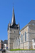 Church of St John the Baptist and its bell tower
 Typical houses in Herve
 Herve, water tower
 Battice, water tower
_154.jpg)


Notable people
edit- André Piters (1931-2014) ,football player
See also
editReferences
edit- ↑ "Wettelijke Bevolking per gemeente op 1 januari 2018". Statbel. Retrieved 9 March 2019.
External links
edit Media related to Herve at Wikimedia Commons
- Ville de Herve - official site
This Liège Province location article is a stub. You can help Wikipedia by adding missing information. |