Gandharwa Chuli, also spelled as Gandharva Chuli or Gandharbha Chuli, is a mountain in Nepal.
| Gandharwa Chuli | |
|---|---|
 West aspect | |
| Highest point | |
| Elevation | 6,248 m (20,499 ft)[1][2] |
| Prominence | 256 m (840 ft)[2] |
| Isolation | 3.03 km (1.88 mi)[2] |
| Coordinates | 28°32′18″N 83°57′44″E / 28.53833°N 83.96222°E[1] |
| Geography | |
 Gandharwa Chuli Location in Nepal | |
 | |
| Interactive map of Gandharwa Chuli | |
Country | Nepal |
Province | Gandaki |
District | Kaski |
Protected area | Annapurna Conservation Area |
| Parent range | Himalayas Annapurna Himal[1] |
| Climbing | |
| First ascent | 2013 |
Description
editGandharwa Chuli is a 6,248-metre (20,499-foot) sacred summit in the Annapurna Himal of the Nepalese Himalayas.[3] It is situated 32 kilometres (20 mi) north of Pokhara in Gandaki Province and the Annapurna Conservation Area. Precipitation runoff from the mountain's east slope drains into headwaters of the Seti Gandaki River, whereas the west slope drains into headwaters of the Modi River. Topographic relief is significant as the summit rises 2,250 metres (7,382 ft) above the Annapurna Sanctuary in three kilometres (1.9 mi). The first officially permitted ascent was made on May 6, 2013, by Cosmin Andron and Christina Pogacean.[1][3]
Climate
editBased on the Köppen climate classification, Gandharwa Chuli is located in a tundra climate zone with cold, snowy winters, and cool summers.[4] Weather systems are forced upwards by the Himalaya mountains (orographic lift), causing heavy precipitation in the form of rainfall and snowfall. Mid-June through early-August is the monsoon season. The months of March, April, October, and November offer the most favorable weather for viewing or climbing this peak.[5]
See also
editGallery
edit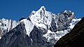 Gandharwa Chuli viewed from Annapurna Sanctuary
 Gandharwa Chuli viewed from Annapurna Sanctuary
 Gandharwa Chuli


References
edit- 1 2 3 4 "Gandharva Chuli". Nepal Himal Peak Profile. Government of Nepal. Retrieved 16 May 2025.
- 1 2 3 "Gandharwa Chuli, Nepal". Peakbagger.com. Retrieved 16 May 2025.
- 1 2 Andron, Cosmin (2014). "Ghandarbha Chuli (6,248m), southwest face and west ridge'". American Alpine Journal. American Alpine Club. Retrieved 16 May 2025.
- ↑ Peel, M. C.; Finlayson, B. L.; McMahon, T. A. (2007). "Updated world map of the Köppen-Geiger climate classification" (PDF). Hydrology and Earth System Sciences. 11 (5): 1633–1644. Bibcode:2007HESS...11.1633P. doi:10.5194/hess-11-1633-2007. Archived (PDF) from the original on 2 December 2019. Retrieved 7 November 2025.
- ↑ Best time to go to Annapurna, whereandwhen.net, Retrieved May 16, 2025.
External links
edit- Account of first ascent: Alpinist.com
- Gandharwa Chuli: weather
- Gandharwa Chuli (photo): Flickr