Fresnicourt-le-Dolmen (French pronunciation: [fʁɛnikuʁ lə dɔlmɛn]) is a commune in the Pas-de-Calais department in the Hauts-de-France region of France[3] about 10 miles (16 km) south of Béthune and 20 miles (32 km) southwest of Lille.
Fresnicourt-le-Dolmen | |
|---|---|
 A general view of Fresnicourt-le-Dolmen | |
 Coat of arms | |
 Location of Fresnicourt-le-Dolmen | |
 Fresnicourt-le-Dolmen  Fresnicourt-le-Dolmen | |
| Coordinates: 50°25′08″N 2°36′02″E / 50.4189°N 2.6006°E | |
| Country | France |
| Region | Hauts-de-France |
| Department | Pas-de-Calais |
| Arrondissement | Béthune |
| Canton | Bruay-la-Buissière |
| Intercommunality | CA Béthune-Bruay, Artois-Lys Romane |
| Government | |
| • Mayor (2020–2026) | Dany Clairet[1] |
Area 1 | 7.95 km2 (3.07 sq mi) |
| Population (2023)[2] | 791 |
| • Density | 99.5/km2 (258/sq mi) |
| Time zone | UTC+01:00 (CET) |
| • Summer (DST) | UTC+02:00 (CEST) |
| INSEE/Postal code | 62356 /62150 |
| Elevation | 77–186 m (253–610 ft) (avg. 188 m or 617 ft) |
| 1 French Land Register data, which excludes lakes, ponds, glaciers > 1 km2 (0.386 sq mi or 247 acres) and river estuaries. | |
Population
edit| Year | Pop. | ±% p.a. |
|---|---|---|
| 1968 | 1,078 | — |
| 1975 | 1,014 | −0.87% |
| 1982 | 974 | −0.57% |
| 1990 | 907 | −0.89% |
| 1999 | 880 | −0.34% |
| 2007 | 847 | −0.48% |
| 2012 | 812 | −0.84% |
| 2017 | 772 | −1.01% |
| 2023 | 791 | +0.41% |
| Source: INSEE[4] | ||
Places of interest
edit- The fifteenth century Château d'Olhain[5]
- The Arboretum d'Olhain
- The neolithic dolmen "La Table des Fées"[6]
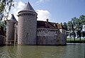 The Château d'Olhain
 The dolmen "La Table des Fées"


See also
editReferences
edit- ↑ "Répertoire national des élus: les maires". data.gouv.fr, Plateforme ouverte des données publiques françaises (in French). 9 August 2021.
- ↑ "Populations de référence 2023" (in French). National Institute of Statistics and Economic Studies. 18 December 2025.
- ↑ INSEE commune file
- ↑ Population municipale entre 1968 et 2023, INSEE
- ↑ Base Mérimée: Château d'Olhain, Ministère français de la Culture. (in French)
- ↑ Base Mérimée: Dolmen La Table des Fées, Ministère français de la Culture. (in French)
External links
editWikimedia Commons has media related to Fresnicourt-le-Dolmen.
This Arrondissement of Béthune geographical article is a stub. You can help Wikipedia by adding missing information. |