
Size of this JPG preview of this TIF file: 796 × 600 pixels. Other resolutions: 319 × 240 pixels | 637 × 480 pixels | 1,020 × 768 pixels | 1,280 × 964 pixels | 2,560 × 1,928 pixels | 10,591 × 7,977 pixels.
Original file (10,591 × 7,977 pixels, file size: 18.34 MB, MIME type: image/tiff)
This is a file from the Wikimedia Commons. Information from its description page there is shown below.
Commons is a freely licensed media file repository. You can help.
Commons is a freely licensed media file repository. You can help.
Summary
| Description |
Deutsch: Karte von Küstrin („Plan de Cüstrin a. O.“)
English: Map of Küstrin ("Plan de Cüstrin a. O.") |
| Date | circa 1700 |
| Source |
Staatsbibliothek zu Berlin – Preußischer Kulturbesitz, Germany, https://resolver.staatsbibliothek-berlin.de/SBB00034AD600000000 Signatur: Kart. X 22186/20, 1 Karte, 49 x 65 cm, Handzeichnung (koloriert) |
| Author | Unknown author |
| Permission (Reusing this file) |
Deutsch: Nutzungsbedingungen der Staatsbibliothek Berlin: „Die von der Staatsbibliothek zu Berlin erzeugten Digitalisate gemeinfreier Vorlagen bleiben gemeinfrei und sind daher mit der Public Domain Mark 1.0 gekennzeichnet.“
English: Terms of use Staatsbibliothek Berlin: “The digitised works of public domain originals produced by the Staatsbibliothek zu Berlin remain in the public domain and are therefore marked with the Public Domain Mark 1.0.” |
Licensing
|
This work is in the public domain in its country of origin and other countries and areas where the copyright term is the author's life plus 100 years or fewer. This work is in the public domain in the United States because it was published (or registered with the U.S. Copyright Office) before January 1, 1931. | |
| This file has been identified as being free of known restrictions under copyright law, including all related and neighboring rights. | |
File history
Click on a date/time to view the file as it appeared at that time.
| Date/Time | Thumbnail | Dimensions | User | Comment | |
|---|---|---|---|---|---|
| current | 17:35, 31 October 2024 | 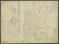 | 10,591 × 7,977 (18.34 MB) | Polarlys | == {{int:filedesc}} == {{Information |Description= {{de|1=Karte von Küstrin („Plan de Cüstrin a. O.“)}} {{en|1=Map of Küstrin ("Plan de Cüstrin a. O.")}} |Source=Staatsbibliothek zu Berlin – Preußischer Kulturbesitz, Germany, https://resolver.staatsbibliothek-berlin.de/SBB00034AD600000000<br />Signatur: Kart. X 22186/20, 1 Karte, 49 x 65 cm, Handzeichnung (koloriert) |Date={{other date|~|1700}} |Author={{unknown|author}} |Permission= {{de|1=[https://digital.staatsbibliothek-berlin.de/nutzungs... |
File usage
The following page uses this file:
Global file usage
The following other wikis use this file:
- Usage on de.wikipedia.org
- Usage on pl.wikipedia.org
- Usage on pt.wikipedia.org