
Diensdorf-Radlow is a municipality in the Oder-Spree district, in Brandenburg, Germany.
Diensdorf-Radlow | |
|---|---|
Location of Diensdorf-Radlow
within Oder-Spree district 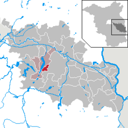 | |
 Location of Diensdorf-Radlow | |
  Diensdorf-Radlow  Diensdorf-Radlow | |
| Coordinates: 52°13′59″N 14°03′00″E / 52.23306°N 14.05000°E | |
| Country | Germany |
| State | Brandenburg |
| District | Oder-Spree |
| Municipal assoc. | Scharmützelsee |
| Subdivisions | 2 districts |
| Government | |
| • Mayor (2024–29) | Stefan Petrick[1] |
| Area | |
• Total | 9.34 km2 (3.61 sq mi) |
| Elevation | 45 m (148 ft) |
| Population (2024-12-31)[2] | |
• Total | 636 |
| • Density | 68.1/km2 (176/sq mi) |
| Time zone | UTC+01:00 (CET) |
| • Summer (DST) | UTC+02:00 (CEST) |
| Postal codes | 15864 |
| Dialling codes | 033677 |
| Vehicle registration | LOS |
| Website | www.amt-scharmuetzelsee.de |
History
editOn 1 January 1962, the municipality of Diensdorf-Radlow was formed by merging the municipalities of Diensdorf and Radlow.
From 1815 to 1947, the constituent localities of Diensdorf-Radlow were part of the Prussian Province of Brandenburg.
After World War II, Diensdorf and Radlow were incorporated into the State of Brandenburg from 1947 to 1952 and the Bezirk Frankfurt of East Germany from 1952 to 1990. Since 1990, Diensdorf-Radlow is again part of Brandenburg.
Demography
edit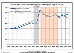
Diensdorf-Radlow: Population development within the current boundaries (2013)[3] | |||||||||||||||||||||||||||||||||||||||||||||||||||||||||||||||||||||||||||||||||||||||||||||||||||||||||||||||||||||||||||||||
|
| ||||||||||||||||||||||||||||||||||||||||||||||||||||||||||||||||||||||||||||||||||||||||||||||||||||||||||||||||||||||||||||||
References
edit- ↑ Landkreis Oder-Spree Wahl der Bürgermeisterin / des Bürgermeisters. Retrieved 10 July 2024.
- ↑ "Bevölkerungsstand im Land Brandenburg Dezember 2024 (Fortgeschriebene amtliche Einwohnerzahlen, basierend auf dem Zensus 2023)" (XLS). Amt für Statistik Berlin-Brandenburg (in German).
- ↑ Detailed data sources are to be found in the Wikimedia Commons.Population Projection Brandenburg at Wikimedia Commons
 | This Brandenburg location article is a stub. You can help Wikipedia by adding missing information. |