U.S. Route 101 (US 101) is a north–south United States Numbered Highway that runs between Los Angeles, California, and Tumwater, Washington. U.S. Route 101 in California covers approximately 808 miles (1,300 km) between the East Los Angeles Interchange and the Oregon border, making it the longest numbered route in California’s highway network.
.svg) U.S. Route 101 | ||||
|---|---|---|---|---|
 US 101 highlighted in red | ||||
| Route information | ||||
| Maintained by Caltrans | ||||
| Length | 808.111 mi[1] (1,300.529 km) Portions of US 101 relinquished to or otherwise maintained by local or other governments are not included in the length | |||
| Existed | November 11, 1926[2][3]–present | |||
| Tourist routes | ||||
| Restrictions | STAA trucks are prohibited through Richardson Grove State Park[6][7] | |||
| Major junctions | ||||
| South end | ||||
| ||||
| North end | ||||
| Location | ||||
| Country | United States | |||
| State | California | |||
| Counties | Los Angeles, Ventura, Santa Barbara, San Luis Obispo, Monterey, San Benito, Santa Clara, San Mateo, San Francisco, Marin, Sonoma, Mendocino, Humboldt, Del Norte | |||
| Highway system | ||||
| ||||
US 101 is a critical freeway in Greater Los Angeles and the San Francisco Bay Area; it is also a communal highway in the Central and North coasts, where it connects cities such as Santa Barbara, San Luis Obispo, Salinas, Eureka, and more. In the Central Coast, US 101 is a mix of freeway and expressway, while the North Coast segment is mostly a two-lane road with pockets of controlled-access configurations. The majority of the route is maintained by the California Department of Transportation.
US 101 was created in 1926, its route taking over or sharing paths with El Camino Real, Redwood Highway, and State Legislative Routes 1 and 2. US 101 originally continued south from Los Angeles, through Orange County and San Diego to the Mexican border, but this segment was switched to I-5 in 1964. Beginning in the 1930s, numerous US 101 segments were replaced or relocated, often to bypass smaller cities. In the 1940s and 1950s, many segments were upgraded to freeway standards, particularly in Southern California, San Jose, and along the San Francisco Peninsula. However, freeway upgrades were curtailed in the 1960s, and while a few sections have been upgraded since then, segments now are more commonly improved without being fully upgraded to freeway standards. Proposed improvements yet to be completed include two freeway caps in Los Angeles, trucking upgrades through Richardson Grove State Park, a 6,000-foot (1,800 m) tunnel in Del Norte County, and the addition of high-occupancy lanes in several areas.
US 101 and many of its features are known by various names. California residents generally refer to the route as "101" or "the 101" (pronounced "one-oh-one"), while segments in Los Angeles are variously named Santa Ana, Hollywood, and Ventura freeways, and segments in the Bay Area are named South Valley, Bayshore, and Central freeways. US 101 south of the Bay Area has been dedicated as El Camino Real, north of the Golden Gate Bridge as Redwood Highway, and the entire route is named both Blue Star Memorial Highway and Coast Highway. Several memorial and tourist designations have been applied to sections of the route, and segments that run concurrently with SR 1 are also known as Pacific Coast Highway, as that is the name of SR 1.
Route description
editUS 101 runs for 808 miles (1,300 km) in California, making it the longest numbered route in the state.[8] It is named Route 101 in Section 401 of the California Streets and Highways Code and defined as:[9]
Route 101 is from:
(a) Route 5 near Seventh Street in Los Angeles to Route 1, Funston approach, and, subject to Section 72.1, the approach to the Golden Gate Bridge in the Presidio of San Francisco via Santa Barbara, San Luis Obispo, and Salinas.
(b) A point in Marin County opposite San Francisco to the Oregon state line via Crescent City.
The definition purposely omits the segment crossing the Golden Gate Bridge, as it is maintained by the Golden Gate Bridge, Highway and Transportation District and is not part of the state highway system. Despite this, U.S. Route logs from the American Association of State Highway and Transportation Officials include the bridge as part of US 101, as do most other maps.[10] The bridge along with the rest of US 101 is also part of the National Highway System.[11]
US 101 is part of the California Freeway and Expressway System,[12] and portions of it are eligible for inclusion in the State Scenic Highway System.[13] It is officially designated a scenic highway between Goleta and Las Cruces in Santa Barbara County[4] and through Del Norte Coast Redwoods State Park in Del Norte County.[5]
Southern California
edit
US 101 begins in Boyle Heights at the East Los Angeles Interchange, a major freeway junction that includes I-5, I-10, and SR 60. The six-lane portion of the route is the northerly continuation of the Santa Ana Freeway, inheriting that name from I-5. After two miles (3.2 km), US 101 turns west at the San Bernardino Split, a three-way junction with the San Bernardino Freeway that transitions into I-10 to the east. US 101 travels across the Los Angeles River before passing Los Angeles Union Station.[14]
Proceeding in a generally northwestern direction, US 101 travels through downtown Los Angeles via the Downtown Slot[15] between the Los Angeles Civic Center and El Pueblo de Los Ángeles, then intersects SR 110 at the Four Level Interchange. Starting here, US 101 is named Hollywood Freeway. It passes through Echo Park, Silver Lake, Los Feliz, and Hollywood, passing Echo Park Lake, the Hollywood Boulevard Commercial and Entertainment District, and the Hollywood Bowl in the process. North of Hollywood, US 101 traverses the Santa Monica Mountains via the Cahuenga Pass before entering the San Fernando Valley. It then passes Universal Studios Hollywood, after which US 101 turns westward at the Hollywood Split, where it supersedes SR 134 on the Ventura Freeway while the Hollywood Freeway continues north as SR 170.[14]
.jpg)
From the Hollywood Split, US 101 runs east–west despite its north–south designation. Because of this, the same freeway entrance can be signed as US 101 North and US 101 West or US 101 South and US 101 East; this is most common in the San Fernando Valley where local signage does not match the Caltrans' statewide designation.[16] Along this segment, US 101 intersects I-405 in Sherman Oaks and SR 27 in Woodland Hills. In Calabasas, US 101 changes from heavily urbanized to a more rural character as it enters the Conejo Valley, where it leaves Los Angeles County and enters Ventura County.[17] In Thousand Oaks, US 101 and SR 23 run concurrently for about 2+1⁄2 miles (4.0 km), between Westlake Boulevard and a three-way interchange with the Moorpark Freeway.[14]
Continuing westward, US 101 climbs the Conejo Grade on a 7% incline[18] before descending into the Oxnard Plain, where it travels through Camarillo and Oxnard. SR 1 and US 101 run concurrently in Oxnard. Upon crossing the Santa Clara River, the highway enters Ventura, where it intersects SR 126 and then SR 33.[14]
Central Coast
edit
US 101/SR 1 crosses the Ventura River at Emma Wood State Beach, at which point its parallels and directly overlooks the Pacific Coast for 12 miles (19 km); 7+1⁄2 miles (12.1 km) of it alongside rather than concurrent with each other (the non-concurrent section of SR 1 is the Rincon Parkway), to Rincon Point. The highway also passes through Faria, Mussel Shoals, and La Conchita along this stretch. It then enters Santa Barbara County, where it intersects SR 150; this is also where the Ventura Freeway name ends. US 101/SR 1 continues through Carpinteria, then returns to the coast for two miles (3.2 km), passing through Summerland and then entering Santa Barbara.[14]
US 101/SR 1 bisects the entire length of Santa Barbara, intersecting SR 154 in the process. It then bisects Goleta, where it intersects SR 217.[14] West of Goleta, the route narrows from six lanes to four and switches from freeway to expressway;[a] it then traverses a 19-mile (31 km) stretch of the Gaviota Coast, again often directly overlooking the shore.[14][17]

At Gaviota, the route turns sharply north and resumes its original north–south alignment. It heads inland across the Santa Ynez Mountains via the Gaviota Pass, where northbound lanes pass through the Gaviota Tunnel, while no tunnel exists in the southbound direction. About 1+1⁄2 miles (2.4 km) north of the Gaviota Tunnel, SR 1 splits from US 101 to resume its role as California's primary coastal highway.[14] Throughout the rest of the Central Coast, US 101 switches between freeway and expressway status,[17] but despite occasional cross-traffic it has unimpeded traffic, as there are no stop signs or traffic signals until San Francisco.[20]
North of the US 101/SR 1 split, US 101 enters Buellton, where it intersects SR 246. North of Buellton, US 101 intersects SR 154 again, and in Los Alamos, it intersects SR 135. In Orcutt, US 101 and SR 166 run concurrently for 3 miles (4.8 km), until north of Santa Maria, where US 101 again intersects SR 135. Vineyards surround US 101 in much of this area.[14]
In San Luis Obispo County, US 101 passes through Nipomo, then intersects SR 227 in Arroyo Grande. US 101 and SR 1 run concurrently again in Pismo Beach. The highway then turns inland to San Luis Obispo, where US 101 reconnects with SR 227, after which SR 1 splits off again.[14] North of San Luis Obispo, US 101 ascends the Santa Lucia Range on a 7% incline via the Cuesta Grade, cresting at 1,522 feet (464 m) before descending north of the range.[21] Here, US 101 intersects SR 58 near Santa Margarita, then enters Atascadero, where it intersects SR 41. US 101 then passes through Templeton, and upon exiting, it and SR 46 run concurrently for about 3 miles (4.8 km) to Paso Robles. US 101 continues north through San Miguel, where it enters Monterey County, then passes Camp Roberts.[14][17]

North of Camp Roberts, US 101 bypasses the San Ardo Oil Field about five miles (8.0 km) south of San Ardo. Between San Lucas and King City, US 101 crosses the Salinas River three times and also intersects SR 198.[14] US 101 then enters the Salinas Valley, known as America's Salad Bowl,[22] where it travels through Greenfield, Soledad, Gonzales, Chualar, and Spence. US 101 then enters Salinas, where it intersects SR 68 and SR 183. North of Salinas, US 101 and SR 156 run concurrently for approximately eight miles (13 km). SR 156 splits off near San Juan Bautista, after which US 101 intersects SR 129.[14] US 101 also crosses the San Andreas Fault in this area.[23]
San Francisco Bay Area
editUS 101 enters the San Francisco Bay Area across the Pajaro River watershed, where it enters Santa Clara County.[24] US 101 then intersects SR 25, then continues north to Gilroy, where it changes from expressway to freeway. US 101 and SR 152 run concurrently for one mile (1.6 km) in this area; after which US 101 passes through San Martin and Morgan Hill in the Santa Clara Valley.[14]
US 101's surroundings become increasingly urbanized as it approaches San Jose, where it intersects SR 85.[17] US 101 bypasses downtown San Jose to the east, passing through largely residential areas and also intersecting I-280 and I-680 at the Joe Colla Interchange. US 101 then turns northwest as it continues through San Jose and intersects I-880, then partially intersects SR 87. US 101 then enters Sunnyvale, where it intersects SR 237 and SR 85, the latter for the second time. US 101 continues northwest through the South Bay, where it passes the campuses of several major technology corporations, including IBM, Intel, Nvidia, and Google.[14]

US 101 enters the San Francisco Peninsula in Palo Alto, where it travels along the western edge of the San Francisco Bay. It enters San Mateo County in East Palo Alto, where it intersects SR 84, then passes through Redwood City, Belmont, and San Carlos. US 101 then intersects SR 92 in San Mateo, then passes the San Francisco International Airport in San Bruno, with direct ramp and flyover connections between the freeway and airport terminals. US 101 then intersects I-380 and traverses the east side of South San Francisco.[14] Here, the scenery briefly becomes more natural as the freeway passes Brisbane east of San Bruno Mountain, at one point traveling on a causeway that separates Brisbane Lagoon from the San Francisco Bay.[25] US 101 then passes Bayview Park, the former location of Candlestick Park.[26][14]
_-1.jpg)
US 101 enters the city and county of San Francisco at Bayview Park, after which it again intersects I-280, this time via the Alemany Maze.[14] US 101 then traverses a three-way interchange with the western terminus of the San Francisco Skyway, the latter of which is signed as I-80 but not defined as such.[27] US 101 then turns west and follows the old Central Freeway viaduct near San Francisco's Civic Center before transitioning to a surface street on Van Ness Drive. Here, MUNI bus lanes traverse the middle of the alignment, which also passes the rear of San Francisco City Hall. US 101 then turns west on Lombard Street, then northwest on Richardson Avenue where it passes the Palace of Fine Arts, after which it continues onto the grade-separated Presidio Parkway. Here, US 101 travels through the Presidio of San Francisco, where it passes through the Main Post and Battery tunnels,[28] then turns northwest as it and SR 1 join near Crissy Field. This shared highway then crosses the Golden Gate Bridge.[14]
North of San Francisco, US 101 travels through the North Bay,[29] first entering Marin County as Redwood Highway,[30] then climbing the Waldo Grade and passing through the Robin Williams Tunnel. US 101 then passes Sausalito and descends to Richardson Bay, where it splits from SR 1 and travels through Mill Valley. Here, US 101 intersects the western end of SR 131, then continues through the twin towns of Corte Madera and Larkspur. US 101 then enters San Rafael, where it partially intersects I-580, then travels through the city east of downtown. Farther north, US 101 intersects SR 37 in Novato, then travels through sparsely populated areas along the northern outskirts of Olompali State Historic Park.[14][31]
North of Olompali State Historic Park, US 101 enters Sonoma County,[14] where vineyards again frequently surround the freeway.[32] US 101 and SR 116 run concurrently between Petaluma and Cotati, after which US 101 continues north through Rohnert Park. US 101 then travels through Santa Rosa, where it intersects SR 12 and passes over Railroad Square via Robert L. Bishop Memorial Bridge.[30] The freeway crosses the Russian River in Healdsburg, then parallels the river through Alexander Valley, where it traverses the western hills as it overlooks the wine-growing valley. It then enters Geyserville, where it and SR 128 run concurrently to Cloverdale.[14]
Northern California
edit
From the Bay Area to the south, US 101 first enters Mendocino County, then crosses the Russian River about one mile (1.6 km) north of the county line. US 101 then changes to an expressway before following the river along Russian River Canyon.[14] While in the canyon, US 101 passes Frog Woman Rock, a massive rock feature central to local Pomo lore,[33] and after exiting the canyon, the route enters Sanel Valley, where it narrows to a two-lane road and crosses the Russian River again. US 101 then enters Hopland, where it intersects SR 175.[17][14]
North of Hopland, US 101 widens to a four-lane freeway as it approaches Ukiah, where it intersects SR 253 and SR 222. In Calpella close to Lake Mendocino, US 101 and SR 20 merge then run concurrently for 15.5 miles (24.9 km),[14] ascending the 1,956-foot (596 m) Ridgewood Summit, US 101's highest elevation in California, in the process.[34] US 101 and SR 20 separate south of Willits, where SR 20 travels through the town while US 101 bypasses it to the east.[14]
US 101 intersects SR 162 north of Willits, then travels through Laytonville inside Long Valley. US 101 then traverses the 1,796-foot (547 m) Rattlesnake Summit,[34] after which it follows the South Fork Eel River. In Leggett, US 101 and SR 1 meet once again, this time at an at-grade intersection. US 101 then makes a series of sharp curves, following the South Fork Eel River into Piercy, where it crosses the river via the Confusion Hill Bridges.[14] US 101 then enters Cooks Valley. SR 271 closely parallels US 101 for two sections of this route: between Cummings and Legget, and Piercy and Cooks Valley; [14] these sections were US 101's old alignment.[35]

US 101 enters Humboldt County in Cooks Valley,[14] then bisects Richardson Grove State Park, where standard-sized trucks in compliance with the Surface Transportation Assistance Act of 1982 are prohibited.[6][7] North of Richardson Grove State Park, US 101 passes through Benbow, then a preserved portion of the original alignment named Avenue of the Giants parallels the route for more than 30 miles (48 km), during which both routes travel through Myers Flat, Weott, and Redcrest, while US 101 bypasses Phillipsville, Miranda, and Pepperwood. Both routes also traverse the eastern boundary of Humboldt Redwoods State Park in this segment, and north of the segment, US 101 crosses the Eel River three times as it travels through Stafford, Scotia,[36] and Rio Dell.[14]
North of Rio Dell, US 101 crosses the Van Duzen River, then intersects the western terminus of SR 36. It then enters Fortuna, then passes through Humboldt Bay National Wildlife Refuge, Humboldt Hill, and Fields Landing. US 101 then enters Eureka, where it parallels North Bay Channel, then transitions to a surface street. As a surface street, US 101 continues north past Fort Humboldt State Historic Park, then turns east on a one-way couplet through downtown, where it intersects SR 255. The couplet ends east of downtown, after which US 101 becomes an unobstructed highway as it crosses the Freshwater Slough via Eureka Slough Bridge. US 101 then curves around Arcata Bay, leaving Eureka in the process, and travels north through Arcata, where it intersects SR 255 again, then intersects SR 299.[17]
US 101 continues north, past McKinleyville on a bluff north of the Mad River, then crosses Big Lagoon north of Trinidad. US 101 then narrows to two lanes and follows a bar between the Freshwater Lagoon and the Pacific Ocean. It then turns inland to Orick, after which it becomes a 14-mile (23 km) undivided freeway that traverses Redwood National and State Parks east of Prairie Creek Redwoods State Park.[17]
.jpg)
US 101 continues north into Del Norte County, where it crosses the Klamath River before entering Klamath.[14] Further north, US 101 traverses Last Chance Grade,[37] then enters Crescent City, where it separates into a one-way couplet for nine blocks. North of Crescent City, US 101 turns northeast and becomes a freeway for three miles (4.8 km). US 101 then intersects the southern terminus of US 199 and continues northward as a two-lane road through the eastern outlying area of Fort Dick. US 101 then crosses the Smith River, then enters the town named of the same name. US 101 then returns to the coast, where it continues north as it passes Pelican State Beach and enters Oregon.[14]
HOV lanes
editAs of 2026[update], high-occupancy vehicle (HOV) lanes were being added to US 101 between Summerland and Santa Barbara, and nearby Carpinteria featured peak-hour HOV lanes as well.[38] HOV lanes are also being considered for a 27-mile (43 km) stretch between SR 23 and SR 33 in Ventura County.[39]
In the Bay Area, part-time HOV lanes have been built sporadically along US 101.[40] The HOV lanes in Marin and Sonoma counties are the second longest in California,[41] with a contiguous length of about 52 miles (84 km) between the Richardson Bay Bridge and Windsor.[42][43][b] In San Francisco, the right lanes of US 101 on Lombard Street have been designated temporary HOV lanes in a pilot project launched by the San Francisco Municipal Transportation Agency in 2021.[44]
Tolls
editUS 101 features high-occupancy toll (HOT) lanes between I-380 in San Bruno and SR 237 in Mountain View,[45][46][47] with plans to extend them to I-880 in 2026.[48] HOT lanes in Santa Clara County are co-administered by the Santa Clara Valley Transportation Authority, while the segment in San Mateo County is co-administered by the San Mateo County Express Lanes Joint Powers Authority.[49]
As of January 2026[update], HOT hours are weekdays between 5:00 a.m. and 8:00 p.m.; outside these hours, they are free and open to all vehicles. Solo drivers are tolled using a congestion pricing system based on real-time traffic levels; two-person carpools are charged half the posted toll and motorcycles and three or more carpools not charged at all. There are no toll booths to receive payment, instead all tolls are collected using an open road tolling system. Each HOT vehicle is required to carry a FasTrak Flex transponder set to indicate the number of occupants. Solo drivers may also use the FasTrak standard tag and drivers without any FasTrak tag will be assessed a toll violation, even if they qualify to use the lane for free.[49][50]
Tolls are also collected for southbound traffic on the Golden Gate Bridge. All-electronic tolling is used and can be paid by either a FasTrak transponder or license plate tolling. The HOV lane leading to the bridge requires three or more riders.[51]
Congestion
editUS 101 in Los Angeles is known for its congestion, which is often amongst the worst in the United States. A 2004 American Highway Users Alliance (AHUA) study found the US 101/I-405 interchange to be the most congested interchange in the nation,[52] a 2015 Auto Insurance Center study found US 101 between downtown Los Angeles and Woodland Hills to be the most congested freeway in the nation,[53] and a 2020 INRIX study found US 101 between SR 110 and SR 134 to be the second most congested corridor in the nation.[54]
US 101 also has significant congestion along the San Francisco peninsula. A 2002 AHUA study found the US 101/I-880 interchange to be the 21st most congested in the nation,[55] and in 2016, the Metropolitan Transportation Commission determined US 101 northbound in San Francisco County and southbound in Santa Clara County were the first and third most congested freeways in the Bay Area.[56]
History
editPrecursors
editEl Camino Real
edit
Long before California entered statehood, 16th-century Alta California had a loose-knit network of transportation paths deemed by the monarchy of Spain as caminos reales, or "royal roads".[57] In the late 18th century, Gaspar de Portolá, under the stewardship of Junípero Serra, led Spanish missionaries on two expeditionary runs in the coastal regions; missions, pueblos, and presidios were also established between San Diego and Monterey during this time.[58] Six years after Portolá's last expedition, Juan Bautista de Anza followed Portolá's trail from present-day Los Angeles to the Presidio of San Francisco.[59] George Wharton James coined the phrase "El Camino Real" for the road that the expeditions traced out in his 1908 travelogue Through Ramona's Country.[60]
Despite modest improvements in the mid-19th century, El Camino Real was difficult for stagecoaches and freight wagons to navigate.[61] The movement to preserve and memorialize El Camino Real began in 1902, when Anna Pitcher of Pasadena presented a plan to restore the route.[62] Later that year, the California Federation of Women's Clubs adopted the project; government agencies and other organizations supported it as well.[63] In 1904, the Los Angeles Chamber of Commerce formed a convention to support the project;[64] a second convention was held in Santa Barbara that same year.[65][66] The first distinctive bells marking El Camino Real were erected in 1906[67][68] and in 1915, the Automobile Club of Southern California produced a map detailing El Camino Real and the missions.[69]
El Camino Real was part of the Pacific Highway, a chain of highways that existed until 1926.[70] In 1924, a roadway that would eventually become part of US 101 replaced an outdated segment of El Camino Real in Ventura;[71] the replaced segment was later re-signed as SR 1.[72] In 1963, all of El Camino Real was codified in the California Streets and Highways Code[73] and also declared California Historical Landmark No. 784;[74][75] the state assumed maintenance of El Camino Real's bell markers that same year.[76]
Redwood Highway
editRedwood Highway | |
 Redwood Highway c. 1930s | |
| Nearest city | Klamath, California |
|---|---|
| Built | 1900–1949 |
| NRHP reference No. | 79000253[77] |
| Added to NRHP | December 17, 1979 |
Prior to the 20th century, almost all commerce on the Redwood Coast was done by sea, whereupon ships would dock at portside towns to transport passengers and deliver and receive goods.[78][79] Amid the backdrop of a sprawling automobile industry, locals and logging companies called for a reliable highway north of the Golden Gate, as at the time, travel by motorcar across these regions could take days.[80][81] In 1910, the California government passed the State Highway Bond Act, authorizing funds for a statewide road system.[79][82]
Construction of Redwood Highway began in Del Norte County in 1917,[82] with another section constructed on tidal wetlands bordering Humboldt Bay between 1918 and 1919.[83] In 1921, Crescent City hotelier A. D. Lee proposed the name Redwood Highway to honor Save the Redwoods League and their work preserving redwood forests in the area.[84] Local communities and the city of San Francisco endorsed the proposal,[85] which was adopted in 1957.[86] The California Highway Commission also set stringent limits on the number of trees that could be cleared during the highway's construction,[82] while the trees that were cut down were often used as guardrails,[87] drainage control devices,[87] or to build a 4,000-foot (1,200 m) trestle over Big Lagoon, at the time the largest native wood structure in the state highway system.[88] Ultimately, increased awareness of the destruction of the redwoods led to the establishment of Redwood National Park.[89]
Landslides and washouts repeatedly frustrated progress on Redwood Highway,[90] with overall construction lasting about nine years, during which the highway opened segment by segment. The highway minus a bridge across Klamath River was complete by the end of 1923;[91] the final bridge, Douglas Memorial Bridge, was dedicated on May 17, 1926[92] and the full highway opened on October 29.[93][94] To boost tourism in the area, the Redwood Highway Association marketed the highway's beauty,[95][96] most successfully with the internationally publicized 480-mile (770 km) Redwood Highway Marathon, held in 1927 and 1928.[97][98] The National Automobile Club also surveyed a split route for Redwood Highway in 1928,[99] but it was not adopted.[100]
Hollywood Freeway
editIn 1924, Los Angeles voters backed the Major Traffic Street Plan to address the city's worsening traffic. A "stop-free express highway" between downtown Los Angeles and the San Fernando Valley via the Cahuenga Pass was included in the plan and the city acquired many residential and commercial properties to make room for it.[101][102]
Creation
editThe American Association of State Highway Officials announced its intent to establish US 101 in California in 1925.[103] The highway was originally envisioned to run for 935 miles (1,505 km) between the Mexican border at Tijuana and the Oregon state line south of Brookings, aligning with the future Hollywood Freeway as well as State Legislative Routes 1 and 2[104] and also occupying El Camino Real and all but the Crescent City–Grants Pass section of Redwood Highway. With this alignment, US 101 would be the westernmost route in the United States Numbered Highway System.[105] Although the three-digit number in US 101 ran afoul with the system's numerical conventions, it was selected for being the next available odd number west of US 99, on the condition that the numeral 101 is treated as two digits instead of three: a 10 and a 1.[106] The US 101 designation was approved on November 11, 1926, with its routing in California mostly unchanged from its conceptual phase.[107][108][c]
US 101's traffic signs were erected by the Automobile Club of Southern California in Southern California and California State Automobile Association in the north. The first signs were placed along the San Diego–Los Angeles segment in January 1928, with the rest placed that summer.[109]
Mexican border to Los Angeles
edit.svg)
At its inception, US 101 traversed San Diego suburbs on Beyer Boulevard in San Ysidro, Broadway in Chula Vista, and National City Boulevard in National City.[110] From there, the route took an erratic path through the city, coming within a few blocks of Balboa Park before turning west and traveling through downtown, then turning north onto India Street. North of Mission Bay, US 101 turned west through Pacific Beach, before turning back north on La Jolla Boulevard and serving the business areas of La Jolla. By the 1940s, however, the downtown section was truncated onto Harbor Drive close to the San Diego Bay[111] and the La Jolla segment rerouted inland on Rose Canyon Road.[112][113]
In Del Mar, US 101 aligned with Torrey Pines bypass, dubbed Million Dollar Highway[114] and built in 1933 to bypass a dangerous highway that predated federal designations.[115] Also in this area, the route traversed the Surf Line and Los Peñasquitos Creek estuary via bridges,[116][117] after which, it continued along the Pacific Coast through Solana Beach, Encinitas, Carlsbad, and Oceanside.[118][119]
US 101 continued past Marine Corps Base Camp Pendleton, where it entered Orange County and passed through San Clemente. At Doheny Park north of San Clemente, US 101 originally split into two routes, with US 101 Alternate serving the beachside cities before converging with the main route in Oxnard,[120] while the main route veered inland through San Juan Capistrano, Laguna Niguel, and Mission Viejo, after which it zigzagged through Irvine and Tustin,[121] with a concentrated section in Tustin once containing the Tustin Garage and up to ten fuel stations for motorists traveling from the south.[122] North of Tustin, US 101 followed Katella Avenue and Spadra Road,[123] then passed through southeastern Los Angeles County on Montebello Boulevard and entered Los Angeles on Whittier Boulevard.[124]
Due to increased traffic, US 101 between Carlsbad and Oceanside was upgraded to freeway standards in the 1950s.[125][112] In 1963, US 101 Alternative was re-designated as SR 1[126] and in 1964, California both streamlined its numbered routes across the state[127] and stipulated that U.S. highways be removed in favor of Interstate highways.[128] As a result, I-5 supplanted US 101 entirely between Los Angeles and the Mexican border,[112][129] after which, many of US 101's former surface roads were relinquished for municipal and county control.[130] The section through Camp Pendleton was closed off to the public,[112] while a majority of the route in northern San Diego County was designated County Route S21.[119] Historic route signs were also added to former sections in San Diego, Del Mar, and Solana Beach.[130]
Los Angeles and the Central Coast
edit
The first section of downtown Los Angeles–San Fernando Valley expressway to open was the Cahuenga Pass Freeway in 1940.[102] This section was extended by 10 miles (16 km) at a cost of $55 million in 1954 ($659 million in 2025),[102] to Vineland Avenue in the San Fernando Valley and Spring Street in downtown's Civic Center, at which point the route was renamed Hollywood Freeway.[131] The Downtown Slot also opened in 1954,[132][108] while the Four Level Interchange, the world’s first stack interchange, was completed in 1949 but not put into full use until 1953.[133] Proposed interchanges with the never built Beverly Hills Freeway near Glendale, Malibu Freeway near Malibu Canyon, and the Laurel Canyon Freeway at the Hollywood Split were canceled in response to freeway revolts in the 1960s and 1970s.[134]
In 1952, the State Highway Commission announced plans for a freeway along El Camino Real through Los Angeles's San Fernando Valley.[135] The route, which previously ran along Ventura Boulevard[136] between Sepulveda Boulevard and the western city limit, was constructed and opened in segments between from 1956 to 1960,[135] and by 1961, US 101 had been upgraded to freeway standards from Los Angeles through Santa Barbara.[137][138] Conejo Grade was built as part of this upgrade; it replaced a windy two-lane road built in 1914.[139] Grade separation in Camarillo was also part of the upgrade; completed in 1954, it eliminated the last railroad crossing on US 101 between Los Angeles and San Francisco.[140]

West of Santa Barbara, US 101 traversed the Gaviota Pass, which was originally part of El Camino Real and was declared California Historic Landmark No. 248 in 1937.[141][142] Gaviota Tunnel opened to northbound traffic in the pass in 1953,[143] with the previous road repurposed for southbound traffic.[144] By 1954, the entire route was upgraded to expressway standards through the pass.[145]
North of Gaviota, bypasses funded by the Collier–Burns Highway Act of 1947[146][147] allowed US 101 to bypass most town centers by the 1950s,[148] although a US 101/SR 1 interchange was constructed in Las Cruces in 1967, destroying the town.[149][150] Conversely, a 1951 study determined that frontage-road businesses along a new Santa Barbara–Buellton alignment saw minimal impact on the businesses' customer volume.[151] This combined with improvements into Santa Ynez Valley lengthened US 101 by 12 miles (19 km), but shortened travel time because it allowed for higher speeds.[152]
In the northern Central Coast, Prunedale Cutoff replaced a more hazardous route over the Gabilan Range via San Juan Grade in 1932[153] and Cuesta Pass opened as an expressway in 1938.[154][155] In Salinas, US 101 was built as a freeway for 10 miles (16 km) by 1954[156] and Sala Road interchange, adopted in 1964, connected to this segment.[157]
San Francisco Bay Area
edit
Bayshore Highway, located on the San Francisco Peninsula, was completed in 1929,[158] the first section to open being a tolled arterial between San Bruno and Visitacion Valley.[159] Between 1929 and 1936,[160] US 101 was signed as US 101W along the peninsula and US 101E along the East Bay to Oakland, the latter then overlapping with US 40 westward across the San Francisco Bay through a ferry connection. The split routes then rejoined at Hyde Street Pier in San Francisco.[161] Additional ferries traversed the Golden Gate prior to completion of the Golden Gate Bridge in 1937.[162]
In 1936, US 101 on the San Francisco Peninsula was truncated at Bayshore Highway, while El Camino Real was re-signed as US 101 Alternate.[160] However, due to local opposition, this section of US 101 was reverted to El Camino Real two years later, while Bayshore Highway was renamed US 101 Bypass.[163] US 101E was also re-signed as SR 17 during this time.[164]
Bayshore Highway was upgraded to freeway standards starting in 1940.[165] The first segment, a 2-mile (3.2 km) stretch between San Mateo and Burlingame, was completed in 1947,[166] making it the Bay Area's first freeway.[167] The freeway was extended to San Jose and San Francisco in 1962,[168] after which it was designated part of US 101 while El Camino Real was re-signed as SR 82.[169] Plans to build a direct connection to the Golden Gate Bridge on the Central Freeway, a northerly continuation of the Bayshore Freeway,[170] were canceled in 1959 due to backlash by residents;[171][172] as a result, only one section of this segment was completed.[173]

In Santa Clara County, a four-lane alignment replaced a windy section of US 101 across the Pajaro River in Sargent in the early 1940s[174] and a 24.6-mile (39.6 km) bypass through southern Santa Clara Valley was adopted in 1961 and constructed in the early 1970s.[175][176] Additionally, Joe Colla Interchange was completed in 1981, after lengthly delays.[177][178]
In Marin County, US 101's Sausalito–San Rafael segment was completed in the early 1930s; construction concluded with a 1⁄4-mile (0.40 km) redwood bridge over Richardson Bay.[179][180] Twin bores of Waldo Tunnel, which connect Sausalito and Marin City at the highest point of Waldo Grade, opened individually in 1937 and 1954,[181][182] and the bridge across Richardson Bay was replaced in 1956.[183] Additionally, numerous North Bay improvements in the 1950s centered on bypassing cities and freeway upgrades.[184][185] An exception was Santa Rosa, where US 101 was routed through the city;[186] even so, the route was upgraded to freeway standards with the completion of Steele Lane interchange in 1965.[187] Additional bypasses were constructed in Novato and Geyserville in the 1970s.[188][189]
Northern California
editWhile Redwood Highway was completed in 1926,[92] some remote sections in Mendocino, Humboldt, and Del Norte counties were redeveloped soon after to improve grades and provide curve corrections. For example, a segment built between Outlet Creek and Reeves Creek in the late 1930s eliminated forty-seven turns[190] and a new 1940s alignment in Piercy lowered the segment's total curvature from 2,978 degrees to 807.[191] Additionally, 6 miles (9.7 km) of the highway in Del Norte county were relocated in the early 1930s, due to landslides along the original route.[91]
Despite these and other upgrades, freeway and expressway segments are not as prevalent on this segment of US 101 compared to elsewhere.[192] A variety of factors, most of which came into play in the middle of the 20th century, contributed to this, most notably local business owners opposed bypasses[193][194] and conservationists opposed the destruction construction of a multi-lane highway would require.[195] Conversely, Eureka-based Times-Standard as well as several local taxpayer groups supported the improved safety that upgrades would bring. The Redwood Empire Association also urged the State Highway Commission to not truncate US 101 outside state park boundaries.[196]
Ridgewood Grade, located in Mendocino County and opened in 1954, was the first section of Redwood Highway upgraded to expressway.[197] The following year, Assemblyman Frank P. Belotti introduced legislation that would allot $10 million ($120 million in 2025) from state park funds towards a 23-mile (37 km) bypass through Humboldt Redwoods State Park. Governor Goodwin Knight later vetoed the bill, after which the two sides agreed to expand the bypass to 44 miles (71 km) around the park and only remove trees with heights less than 6 feet (1.8 m). This bypass was completed in the 1960s at an estimated $36 million ($426 million in 2025), while the old alignment, known as the Avenue of the Giants, became SR 254.[198][199]
In Eureka, Big Lagoon trestle was demolished in favor of embankments carrying a 3-mile (4.8 km) expressway, which opened in 1959 at a cost of $1.84 million ($203 million in 2025).[200] Additionally, the Arcata–Trinidad freeway located north of Eureka was completed by the early 1960s,[201] as was a second freeway section from Hydesville to south of Eureka with bypasses at Fortuna and Loleta.[202][203] The southern segment was augmented by the Herrick Avenue interchange in 1984.[176]
Elsewhere along Redwood Highway, a 14+1⁄2-mile (23.3 km) freeway upgrade was completed in Ukiah in 1965,[204] then extended north through Redwood Valley in the late 1980s,[205] and a $1 million ($10.7 million in 2025), thirteen-span viaduct opened across Eel River in 1964.[206] Additionally, numerous bridges were damaged during the Christmas flood of 1964,[207][208] each of which was repaired or replaced by the following March, the last being a new construction that replaced Douglas Memorial Bridge over Klamath River.[209]
Modern developments
editLos Angeles and the Central Coast
editThe last traffic signal on US 101 between Los Angeles and San Francisco, located in Santa Barbara, was removed in 1991.[210] A lane was added in both directions of the Ventura Freeway in the 1990s, eliminating several bottlenecks,[135] and the Van Nuys Boulevard on and off-ramps were widened to reduce congestion at the nearby US 101/I-405 interchange in 2011.[211] New lanes and truck pullouts were added to Cuesta Grade in 2004[21] and three interchanges were added in Prunedale in 2014.[157] A four-phase widening project to add a lane in each direction in the Santa Barbara area began construction in 2008; its final phase, which includes the addition of high-occupancy lanes, began in 2020, at which point the phase was estimated to cost $700 million ($871 million in 2025) and be completed in 2027.[212][213]

In 2024, the city of Los Angeles undertook a beautification project on 8.7 miles (14.0 km) of US 101 in Hollywood, the project emphasizing the movie culture in the area and featuring amongst other artwork a 22-foot (6.7 m) steel art sculpture depicting fluttering filmstrips in the freeway median.[214] Construction of the Wallis Annenberg Wildlife Crossing also began in 2024; this crossing, a vegetated overpass spanning US 101 in Agoura Hills, will connect the Santa Monica Mountains with the Simi Hills and upon completion will be the largest wildlife crossing in the world.[215]
San Francisco Bay Area
editIn 1984, San Mateo and Santa Clara County residents voted to use sales tax funds to fund high-occupancy vehicle (HOV) lanes on US 101 in their counties.[216] These lanes were extended through San Jose in 1990 and into Morgan Hill by 2003[217][218] and the Mountain View–Redwood City section was converted to high-occupancy toll lanes in 2022,[45][46] then extended to San Bruno in 2023.[47][219] Furthermore, US 101 was expanded to eight lanes between SR 85 in San Jose and Cochrane Road in Morgan Hill in 2003 and a new interchange at Bailey Avenue, planned since the 1970s, opened in 2004.[220]
The 1989 Loma Prieta earthquake caused severe damage to San Francisco's Central Freeway, prompting its immediate closure.[221][222] In 1997, a narrow majority of residents voted to rebuild the freeway; however, another vote the following year saw the majority vote for it to be dismantled, and this vote was affirmed the year after that.[223][224][225] Demolition was completed by 2005 and the vacated right-of-way was redeveloped into Octavia Boulevard.[226][227]

In 2000, Caltrans and the Metropolitan Transportation Commission unveiled a joint plan to build continuous HOV lanes on US 101 throughout the North Bay.[228] At the time, facilities were already existent in Marin County, having been converted from contraflow bus lanes in the 1980s,[229] but a gap at San Rafael was not filled until 2011.[230] HOV lanes opened in Sonoma County in 2022[231][232] and the final segment between Petaluma and Sonoma County opened in 2025;[233][234] these segments were also part of a separate 30-year, $1.5 billion US 101 improvement project that was completed in 2025.[235] As part of this project, HOV lanes were built between Novato and Sonoma County, the entire route between Novato and Petaluma was upgraded to freeway standards, and new bridges were built across the San Antonio Creek and Petaluma River.[233][236]
In 2009, a project began to replace US 101's approach to Golden Gate Bridge through the Presidio. The new approach, known as Presidio Parkway, incorporated two sets of tunnels and opened in 2015,[237] while the Presidio Tunnel Tops recreational area, located above the tunnels, opened in 2022.[238] Also in 2022, San Francisco Municipal Railway built center bus lanes and landscaped medians on Van Ness Avenue, including its US 101 segment, as part of the Van Ness Bus Rapid Transit project.[239]
Northern California
editUS 101 was truncated onto a new alignment through Prairie Creek Redwoods State Park from the late 1980s to early 1990s.[176] A 4-mile (6.4 km) bypass in Cloverdale was completed in 1994 at a cost of $40 million ($86.9 million in 2025); the project also added frontage roads and relocated Northwestern Pacific Railroad trackage.[240] In 2009, a section of US 101 north of Leggett was moved across Eel River via the Confusion Hill Bridges in order to prevent the infrequent but expensive winter closures that occurred along the old alignment.[241] Additionally, a 6-mile (9.7 km) bypass at Willits broke ground in 2013 and was completed in 2016, more than sixty years after initially proposed.[242] This project, controversial because it re-routed US 101 through protected wetlands,[243] cost $459 million ($616 million in 2025),[244] included a 1.1-mile (1.8 km) viaduct across a flood plain,[245] and re-located the US 101/SR 20 interchange from inside city limits to south of the city. As of 2025[update], the remainder of the old route was still part of the state highway system, under the designation 101U (for unrelinquished).[246]
Future
editIn Los Angeles, two plans to cap US 101 have been proposed: one downtown[247] and the other in Hollywood,[248] with the Hollywood Freeway cap estimated to cost $1 billion in 2015 (equivalent to $1.29 billion in 2024[249])[250] and the downtown cap $180 million in 2017 (equivalent to $226 million in 2024[249]).[247] Elsewhere in Southern California, a long term traffic reduction project for a 27-mile (43 km) stretch between SR 23 and SR 33 was under study as of 2026[update].[39]
In San Luis Obispo County, an $85 million traffic easement project in Pismo Beach began in 2026,[251] with an expected completion date of December 2028,[252] and improvements between Cuesta Grade and the northern county line are also under study.[253] In Monterey County, preliminary work on multiple improvements to an eight-mile (13 km) stretch between Salinas and Chualar, the result of which would upgrade the corridor from expressway to freeway,[254] began in 2024, with construction scheduled to begin in 2031.[255] The US 101/SR 156 interchange has also been proposed for reconstruction and US 101 upgraded from expressway to freeway through it.[254]
Numerous upgrades to US 101 are either under study or in the works in the Bay Area. In San Mateo County, improvements to the US 101/SR 92 interchange are scheduled to begin in 2027[256] and the county also has plans to add 22 miles (35 km) of express lanes between I-380 and the north county line, after which express lanes would span the entire county.[257][258] A $135 million construction project to improve the US 101/SR 25 interchange began in 2025 with an expected completion in 2027,[259] while a US 101/SR 84 improvement project is scheduled to begin construction in 2027.[260] In more long term plans, several proposals have been made to address sea level rise on a particularly vulnerable stretch of US 101 in Marin City by 2050.[261]

In Northern California, Caltrans determined in 2000 that a bypass around Richardson Grove State Park was cost-prohibitive and instead recommended the section be realigned in compliance with the Surface Transportation Assistance Act of 1982,[6][7] but as of 2026[update], construction on the re-alignment had not begun.[262] Caltrans has also proposed a 6,000-foot (1,800 m) tunnel between Klamath and Crescent City that would replace Last Chance Grade; the tunnel was estimated to cost $2 billion in 2026.[263][264] Smaller projects in Northern California include fixing a portion of US 101 slipping into the South Fork Eel River near the Mendocino–Humboldt county line.[265]
Names and memorials
editThe entirety of US 101 in California is named Coast Highway and Blue Star Memorial Highway. Various segments also have additional names and/or memorial designations, although most are not used colloquially.[30] Instead, California residents usually refer to US 101 as "101" ("one-oh-one"), or in the case of southern Californians, "the 101".[266]

In Southern California, US 101 is named Santa Ana Freeway in downtown Los Angeles between the route’s southern end and SR 110,[30] Hollywood Freeway in Los Angeles between SR 110 and SR 170,[30] and Ventura Freeway between SR 134 in Los Angeles and the western Ventura County border.[30][267] US 101 is also named Screaming Eagles Highway in Ventura County and this section is also part of the National Purple Heart Trail.[30][268]
Along the Central Coast, various segments of US 101 are named El Camino Real or El Camino Real Freeway;[269] some segments also coincide with the Juan Bautista de Anza National Historic Trail[270][271] and the entire route, including all of US 101 in Santa Barbara, San Luis Obispo, and Monterey counties, is part of the National Purple Heart Trail.[30] Additionally, in Monterey County, US 101 is named John Steinbeck Highway between SR 68 and Espinoza Road/Russel Road in Salinas and Gateway to the Pinnacles Highway between Arroyo Seco Road and Camphora Gloria Road near Soledad.[30]
US 101 has numerous names in the Bay Area. In the South Bay, US 101 is named South Valley Freeway between Gilroy and SR 85 in San Jose,[272] Sig Sanchez Highway in Santa Clara County between the Morgan Hill Bypass and an undefined point,[30] and Bayshore Freeway between SR 82 in San Jose and I-80 in San Francisco.[30] In San Francisco, US 101 is named Central Freeway between I-80 and Mission Street,[273] near Potrero Hill the route is often called Hospital Curve due to its proximity to San Francisco General Hospital,[14][274] and the route’s surface street sections are commonly referred to by their street names.[14] US 101 is named Redwood Highway throughout the entirety of the North Bay; it is also named William T. Bagley Freeway between the Waldo Tunnel in Sausalito and I-580 in San Rafael[30][275] and Colonel William R. “Bill” Lucius Highway between the southern Sonoma County border and Russian River south of Healdsburg.[30]
In Northern California, US 101 is named Redwood Highway for almost its entire length; only the 16 miles (26 km) between US 199 and the Oregon border is not.[14] US 101 also has several other names in this area. In Humboldt County, it is named Leo Stanley Hulett Highway in Willits,[30] Frank P. Belotti Highway between the southern terminus of Avenue of the Giants and Englewood,[14][30] and Don Clausen Highway along the Redwood National Park bypass. Additionally, in Eureka, US 101 is known by various names: Michael J. Burns Freeway on the expressway,[276] Broadway on the north–south street segment[277][278] (largely unsigned and not registered on Caltrans' logs),[14][30] and by its street names along its downtown couplet.[279] US 101 is also known by its street names along its Crescent City couplet.[14]

Dozens of segments of US 101 in California are designated as memorial routes. Differing segments in Humboldt, Sonoma, Marin, and Monterey counties are named various forms of Veterans Memorial Highway, the segment between Ralston Avenue in Belmont and SR 92 is named Civilian Women Volunteer All Wars Memorial Freeway, a segment near Soledad State Prison is named Soledad State Prison Correctional Officers Memorial Highway, and a segment near Chualar is named Bracero Memorial Highway. Additionally, several memorial freeways and highways are named after individuals, most notably James Lick Memorial Freeway in San Francisco.[30]
Many of US 101's individual features are also named, including interchanges (East Los Angeles Interchange, Four Level Interchange, Hollywood Split, Joe Colla Interchange),[280][281] bridges and viaducts (Golden Gate Bridge, Confusion Hill Bridges, many others),[30] and more. Some intersections have also been unofficially nicknamed, including East Los Angeles Interchange (Malfunction Junction, the Beast),[282][283] Four Level Interchange (Four Letter Interchange),[283] US 101/I-80 (Alemany Maze),[284] and US 101/Cesar Chavez Street/Bayshore Boulevard/Potrero Avenue (The Hairball).[285] Furthermore, Bayshore Highway was unofficially nicknamed Bloody Bayshore before it was upgraded to freeway standards[286] and US 101 between Petaluma and Novato was known as Novato Narrows[287] before high-occupancy vehicle lanes were added in 2025.[288][289]
Finally, because SR 1 is known as Pacific Coast Highway (or PCH for short), the segments of US 101 that run concurrently with it are also known by this name.[290]
Major intersections
editExcept where prefixed with a letter, postmiles were measured on the road as it was in 1964, based on the alignment that existed at the time, and do not necessarily reflect current mileage. R reflects a realignment in the route since then, M indicates a second realignment, L refers to an overlap due to a correction or change, and T indicates postmiles classified as temporary ().[1] Segments that remain unconstructed or have been relinquished to local control may be omitted. The numbers reset at county lines; the start and end postmiles in each county are given in the county column.
| County | Location | Postmile [1][291][292] | Exit [293] | Destinations | Notes |
|---|---|---|---|---|---|
| Los Angeles LA S0.00-38.19 | Los Angeles | | — | No access to I-5 north; southern terminus of US 101; southern end of East Los Angeles Interchange | |
| | — | Euclid Avenue | Southbound exit and northbound entrance | ||
| | — | Southbound exit and northbound entrance; northern end of East Los Angeles Interchange proper; SR 60 west exit 1C | |||
| S0.00 | 1A | Seventh Street | Southbound exit and northbound entrance | ||
| | Whittier Boulevard | Northbound entrance only | |||
| S0.62 | 1A | Fourth Street | No northbound entrance; signed as exit 1B southbound | ||
| S0.91 | 1B | First Street | No southbound entrance; signed as exit 1C southbound | ||
| | 1C | Cesar Chavez Avenue | Northbound exit only; was formerly Brooklyn Avenue | ||
| S1.33 0.00 | 1D | No southbound entrance; San Bernardino Split portion of the East Los Angeles Interchange; access to I-10 east via the San Bernardino Freeway spur; no access to I-10 west; left exit southbound; I-10 west exit 19B; former western terminus of US 60 / US 70; former US 99 south;[294] former I-110 east (1958–1965) | |||
| 0.10 | 1E | Mission Road | No northbound exit | ||
| 0.62 | 2A | Vignes Street | Northbound exit and entrance | ||
| 0.62– 0.82 | 2A-B | Alameda Street – Union Station | Signed as exit 2A southbound, 2B northbound | ||
| 0.82 | 2B | Los Angeles Street | No northbound exit | ||
| 1.10 | 2C | Spring Street | Northbound exit only | ||
| 1.10 | 2C | Broadway | Southbound exit and northbound entrance | ||
| 1.40 | 3A | Temple Street | Southbound exit and entrance | ||
| 1.57 | 3B | Northern end of Santa Ana Freeway; southern end of Hollywood Freeway[295] access to I-110 south via SR 110 south; Four Level Interchange; Grand Avenue not signed southbound; signed as exit 3 northbound; SR 110 exit 24A | |||
| 2.48 | 4A | Glendale Boulevard, Echo Park Avenue, Union Avenue | Union Avenue not signed northbound; Echo Park Avenue not signed southbound | ||
| 2.86 | 4B | Southern end of SR 2 overlap | |||
| 3.34 | 5A | Rampart Boulevard, Benton Way | |||
| 3.76 | 5B | Silver Lake Boulevard | |||
| 4.40 | 6A | Vermont Avenue | |||
| 4.85 | 6B | Melrose Avenue, Normandie Avenue | |||
| 5.55 | 7 | Northern end of SR 2 overlap | |||
| 6.25 | 8A | Sunset Boulevard | No northbound entrance | ||
| 6.52 | 8B | Hollywood Boulevard | |||
| 6.91 | 8C | Gower Street | |||
| 7.06 | 9A | Vine Street | Southbound exit only | ||
| 7.46 | 9B | Cahuenga Boulevard – Hollywood Bowl | Signed as exit 9A northbound | ||
| 7.84 | 9C | Highland Avenue – Hollywood Bowl | Former SR 170 south; signed as exit 9B northbound | ||
| 8.84 | Cahuenga Pass, elevation 745 feet (227 m)[296] | ||||
| 9.22 | 11A | Barham Boulevard – Burbank | No southbound exit, which was permanently closed on October 17, 2015, due to weaving concerns with the construction of the new Universal Studios Boulevard southbound onramp.[297] | ||
| 9.60 | 11B | Universal Studios Boulevard | No southbound exit; serves Universal Studios Hollywood | ||
| 10.34 | 12A | Lankershim Boulevard – Universal City | Serves Universal Studios Hollywood | ||
| 10.56 | 12B | Ventura Boulevard | No southbound exit | ||
| 11.11 | 12C | Signed as exit 12B southbound; "to SR 134" not signed southbound | |||
| | Moorpark Street | Northbound entrance only | |||
| 11.80 | 13 | Northbound left exit and southbound left entrance; southbound access is via exit 13A; US 101 north transitions onto Ventura Freeway west;[295] southern end of Hollywood Split; SR 170 south exit 5A | |||
| 11.83 | 13A | Southbound exit and northbound entrance | |||
| 11.65 | 13B | Southbound exit and northbound entrance; northbound access is via exit 12C; US 101 south transitions onto Hollywood Freeway south;[295] northern end of Hollywood Split; SR 134 west exit 1A | |||
| 12.85 | 14 | Laurel Canyon Boulevard – Studio City | |||
| 13.88 | 15 | Coldwater Canyon Avenue | |||
| 14.89 | 16 | Woodman Avenue | |||
| 15.91 | 17 | Van Nuys Boulevard | |||
| 16.94 | 18 | Sepulveda Boulevard | Northbound exit and southbound entrance | ||
| 17.17 | 19A | I-405 exit 63B | |||
| 17.50 | 19B | Haskell Avenue | No southbound entrance | ||
| 18.61 | 20 | Hayvenhurst Avenue | Northbound exit and southbound entrance | ||
| 19.22 | 21 | Balboa Boulevard – Encino | |||
| 20.23 | 22 | White Oak Avenue | |||
| 21.25 | 23 | Reseda Boulevard | |||
| 22.25 | 24 | Tampa Avenue | |||
| 23.26 | 25 | Winnetka Avenue – Woodland Hills | |||
| 24.31 | 26A | De Soto Avenue, Serrania Avenue | Signed as exit 26 southbound | ||
| 24.85 | 26B | Canoga Avenue | Northbound exit and southbound entrance | ||
| 25.34 | 27 | Signed as exits 27A (north) and 27B (south) northbound | |||
| 25.76 | 27C | Shoup Avenue | Northbound exit and southbound entrance | ||
| 26.45 | 28 | Fallbrook Avenue | Southbound exit only | ||
| 26.86 | 28 | Woodlake Avenue | Northbound exit and entrance | ||
| 27.36 | 29 | Mulholland Drive, Valley Circle Boulevard | |||
| Calabasas | 28.29 | 30 | Parkway Calabasas | ||
| 31.06 | 32 | Las Virgenes Road (CR N1) – Malibu Canyon | |||
| 31.92 | 33 | Lost Hills Road | |||
| Agoura Hills | 32.79 | 34 | Liberty Canyon Road | ||
| | Wallis Annenberg Wildlife Crossing (planned to opened in early 2026)[298] | ||||
| 33.69 | 35 | Chesebro Road | |||
| 35.04 | 36 | Kanan Road (CR N9) | |||
| 36.18 | 38 | Reyes Adobe Road | |||
| Westlake Village | 37.54 | 39 | Lindero Canyon Road | ||
| Ventura VEN 0.00-R43.62 | Thousand Oaks | 0.70 | 40 | Southern end of SR 23 overlap | |
| 1.62 | 41 | Hampshire Road | |||
| 3.02 | 43A | Rancho Road | Signed as exit 43B northbound | ||
| 3.11 | 43B | Northern end of SR 23 overlap; signed as exit 43A northbound; SR 23 south exits 12A-B; Simi Valley not signed southbound | |||
| 4.06 | 44 | Moorpark Road | |||
| 5.05 | 45 | Lynn Road | |||
| 6.19 | 46 | Ventu Park Road – Newbury Park | |||
| 7.02 | 47A | Rancho Conejo Boulevard, Borchard Road | Signed as exits 47A (Rancho Conejo Boulevard) and 47B (Borchard Road) northbound | ||
| 7.89 | 47B | Wendy Drive – Newbury Park | Signed as exit 47C northbound | ||
| 9.10 | Weigh station | ||||
| Camarillo | 10.74 | 50 | Camarillo Springs Road – Camarillo Grove County Park | Signed as exit 51 northbound | |
| 12.30 | 52 | Santa Rosa Road, Pleasant Valley Road | |||
| 13.75 | 53A | Flynn Road | Northbound signage | ||
| Dawson Drive | Southbound signage | ||||
| 13.85 | 53B | ||||
| 14.80 | 54 | Carmen Drive | |||
| 15.89 | 55 | Las Posas Road | |||
| 16.79 | 56 | Springville Drive | |||
| 17.75 | 57 | Central Avenue | |||
| Oxnard | 19.17 | 59 | Del Norte Boulevard | ||
| 20.08 | 60 | Southern end of SR 1 overlap | |||
| 21.01 | 61 | Rose Avenue | |||
| 22.01 | 62A | ||||
| 22.73 | 62B | Oxnard Boulevard | Former SR 1 south | ||
| 23.12 | 63A | Ventura Road | Southbound exit only | ||
| Ventura | R23.45 | 63B | Johnson Drive | Signed as exit 63 northbound | |
| R24.65 | 64 | Victoria Avenue – Channel Islands Harbor | |||
| 25.97 | 65 | Telephone Road | Northbound entrance is via Main Street | ||
| 26.39 | 66A | Signed as exit 66 southbound; southbound entrance is via exit 1C from SR 126 west; SR 126 west exit 1A | |||
| 26.72 | 66B | Main Street (US 101 Bus. north) | No southbound exit | ||
| 28.45 | 68 | Seaward Avenue | |||
| 29.45 | 69 | Vista del Mar Drive, Sanjon Road | Northbound exit and southbound entrance | ||
| 30.15 | 70A | California Street, Ventura Avenue | |||
| 30.91 | 70B | ||||
| 31.50 | 71 | Main Street (US 101 Bus. south) | Southbound exit and northbound entrance | ||
| | R32.70 | 72 | Northern end of SR 1 overlap; northbound exit and southbound entrance | ||
| | R38.98 | 78 | Southern end of SR 1 overlap | ||
| | R39.80 | 79 | Mussel Shoals (Old Pacific Coast Highway) | Southbound exit and entrance | |
| | 41.00 | 81 | La Conchita (West Surfside Street) | Northbound exit and entrance | |
| | 42.18 | 82 | Water Station Road | Northbound exit and entrance | |
| | R43.57 | 83 | Bates Road | ||
| | R43.62 | Northwestern end of Ventura Freeway[295] | |||
| Santa Barbara SB R0.00-90.99 | Carpinteria | R0.63 | 84 | ||
| 1.61 | 85 | Bailard Avenue | |||
| 2.64 | 86A | Casitas Pass Road | Signed as exit 86 northbound; former SR 224 | ||
| 3.06 | 86B | Linden Avenue | Southbound exit and northbound entrance | ||
| 3.77 | 87A | Reynolds Avenue, Santa Monica Road | Signed as exit 87 northbound | ||
| 4.34 | 87B | Carpinteria Avenue | Southbound exit only | ||
| Toro Canyon | R5.28 | 88 | Santa Claus Lane, South Padaro Lane | South Padaro Lane not signed southbound | |
| Summerland | R7.14 | 90 | Padaro Lane – Summerland | Signed as North Padaro Lane northbound | |
| R8.26 | 91 | Evans Avenue – Summerland | |||
| Montecito | 9.00 | 92 | Sheffield Drive | ||
| 10.02 | 93 | San Ysidro Road | |||
| 10.54 | 94A | Olive Mill Road, Coast Village Road | No northbound entrance | ||
| Santa Barbara | 11.10 | 94B | Hermosillo Road | Northbound exit only | |
| 11.41 | 94C | Cabrillo Boulevard, Coast Village Road | No southbound entrance; signed as exit 94B southbound | ||
| | 95 | Los Patos Way (unsigned) | Southbound exit only | ||
| 12.10 | 95 | Salinas Street | Northbound exit and entrance | ||
| 12.75 | 96 | Milpas Street | Former SR 144; northbound exit signed as exit 96A; southbound as exits 96B and 96A | ||
| 13.49 | 96 | Laguna Street, Garden Street – Downtown Santa Barbara | Laguna Street/Garden Street northbound exit signed as exit 96B; Garden Street southbound exit signed as exit 96C | ||
| R14.19 | 97 | Bath Street, Castillo Street; Santa Barbara Harbor | |||
| R14.76 | 98A | Carrillo Street – Downtown Santa Barbara | Signed as exit 98 southbound | ||
| 15.26 | 98B | Arrellaga Street | Northbound exit and entrance | ||
| R15.73 | 99A | Mission Street | Signed as exit 99 southbound | ||
| 16.05 | 99B | Pueblo Street | Northbound exit only | ||
| 16.55 | 100 | Las Positas Road | Former SR 225 | ||
| 17.78 | 101A | La Cumbre Road, Hope Avenue | |||
| 18.38 | 101B | ||||
| Eastern Goleta Valley | 18.92 | 102 | El Sueno Road | Northbound exit and entrance | |
| 20.06 | 103 | Turnpike Road | |||
| Goleta | 21.15 | 104A | Patterson Avenue | Signed as exit 104 southbound | |
| 21.41 | 104B | Northbound exit and southbound entrance | |||
| 22.53 | 105 | Fairview Avenue | |||
| 23.72 | 107 | Los Carneros Road | |||
| 24.77 | 108 | Glen Annie Road, Storke Road | |||
| 26.91 | 110 | Winchester Canyon Road, Hollister Avenue | All ramps are via Cathedral Oaks Road | ||
| | | Northern end of freeway | |||
| | | Southern end of freeway | |||
| | 30.06 | 113 | Dos Pueblos Canyon Road | ||
| | | Northern end of freeway | |||
| | | Southern end of freeway | |||
| | 32.84 | 116 | El Capitan Ranch Road | ||
| | 33.85 | 117 | El Capitan State Beach | ||
| | 36.62 | 120 | Refugio Road – Refugio State Beach | ||
| | | Northern end of freeway | |||
| Gaviota | 44.82 | 128 | Mariposa Reina | Interchange | |
| | Gaviota State Beach (Gaviota Beach Road) | At-grade intersection | |||
| Gaviota Pass | 46.30– 46.90 | Gaviota Rest Area | |||
| 47.19 | Gaviota Gorge Tunnel (northbound only) | ||||
| | | Southern end of freeway | |||
| Las Cruces | R48.85 | 132 | Northern end of SR 1 overlap | ||
| | | Northern end of freeway | |||
| | | Southern end of freeway | |||
| Buellton | R56.46 | 139 | Santa Rosa Road | ||
| R57.12 | 140A | ||||
| R57.55 | 140B | McMurray Road, Avenue of the Flags | |||
| | | Northern end of freeway | |||
| | | Southern end of freeway | |||
| | 62.67 | 146 | |||
| | | Northern end of freeway | |||
| | | Southern end of freeway | |||
| Los Alamos | 70.92 | 154 | |||
| | | Northern end of freeway | |||
| | | Southern end of freeway | |||
| | 78.69 | 161 | Solomon Summit Undercrossing | ||
| Orcutt | 82.18 | 164 | Clark Avenue – Orcutt | ||
| 83.42 | 166 | Union Valley Parkway | |||
| Santa Maria | 84.36 | 167 | Santa Maria Way (US 101 Bus. north) | ||
| 86.59 | 169 | Betteravia Road – Sisquoc | |||
| 87.60 | 170 | Stowell Road | |||
| 88.60 | 171 | Southern end of SR 166 overlap | |||
| 89.69 | 172 | Donovan Road | |||
| 90.75 | 173 | ||||
| San Luis Obispo SLO 0.00-R69.32 | | 0.81 | 175 | Northern end of SR 166 overlap | |
| Nipomo | 4.85 | 179 | Tefft Street – Nipomo | ||
| 6.43 | 180 | Willow Road | |||
| 7.84 | 182 | Thompson Road, Los Berros Road | |||
| | | Northern end of freeway | |||
| | | Southern end of freeway | |||
| Arroyo Grande | 12.52 | 186 | Traffic Way (US 101 Bus. north), Fair Oaks Avenue | No northbound entrance | |
| 13.17 | 187A | ||||
| 13.75 | 187B | Brisco Road, Halcyon Drive | |||
| Pismo Beach | 14.61 | 188 | Oak Park Road | ||
| 15.58– 15.88 | 189 | 4th Street, Five Cities Drive | Signed as exits 189 (4th Street) and 190A (Five Cities Drive) southbound | ||
| 16.62 | 190 | Price Street (US 101 Bus. north) | No northbound entrance; northbound signage | ||
| 190B | Hinds Avenue, Price Canyon Road | No northbound entrance; southbound signage | |||
| 16.89 | 191A | Wadsworth Avenue | Northbound signage; northbound entrance via Bello Street, southbound entrance via Price Street | ||
| Southbound signage; north and south entrances via Price Street | |||||
| 17.76 | 191B | Shell Beach Road | Northbound signage | ||
| Price Street (SR 1 south, US 101 Bus. south) | Southern end of SR 1 overlap; southbound signage | ||||
| R19.81 | 193 | Spyglass Drive | Northbound signage | ||
| Shell Beach Road | Southbound signage | ||||
| Avila Beach | R21.11 | 195 | Avila Beach Drive | ||
| R22.29 | 196 | San Luis Bay Drive – See Canyon, Avila Beach | |||
| | R24.30 | 198 | Higuera Street | ||
| San Luis Obispo | 25.91 | 200A | Los Osos Valley Road | Signed as exit 200 southbound | |
| 26.83 | 200B | Prado Road, Elks Lane | Northbound exit and entrance | ||
| 27.50 | 201 | ||||
| 28.07 | 202A | Marsh Street | |||
| 28.81 | 202B | Broad Street | |||
| 29.08 | 203A | Osos Street, Santa Rosa Street | |||
| 29.08 | 203B | Northern end of SR 1 overlap | |||
| 29.40 | 203C | California Boulevard | |||
| 29.77 | 203D | Grand Avenue – Cal Poly | Northbound exit and southbound entrance | ||
| 29.99 | 204 | Monterey Street | No southbound entrance | ||
| | | Northern end of freeway | |||
| | 35.00[299] | Cuesta Pass, elevation 1,522 feet (464 m)[299] | |||
| | | Southern end of freeway | |||
| | 37.85 | 211 | |||
| Atascadero | 42.27 | 216A | Santa Barbara Road | Signed as exit 216 southbound | |
| 42.90 | 216B | San Diego Way | Northbound exit and southbound entrance | ||
| 44.01 | 218A | Santa Rosa Road | |||
| 44.84 | 218B | Curbaril Avenue | |||
| 45.57 | 219 | ||||
| 45.96 | 220A | Traffic Way (US 101 Bus. north) | |||
| 46.87 | 220B | San Anselmo Road | |||
| 48.33 | 222 | Del Rio Road (US 101 Bus. south) | |||
| 49.32 | 223 | San Ramon Road, Santa Cruz Road | |||
| Templeton | 50.64 | 224 | Vineyard Drive (US 101 Bus. north) | ||
| 51.45 | 225 | Las Tablas Road | |||
| 52.44 | 226 | Main Street (US 101 Bus. south) | |||
| Paso Robles | 53.89 | 228 | Southern end of SR 46 overlap | ||
| 55.67 | 229 | Spring Street (US 101 Bus. north) | Northbound exit and southbound entrance; former US 101 | ||
| 56.14 | 230 | Pine Street | Southbound exit and entrance | ||
| | 230 | Paso Robles Street | Northbound exit and entrance | ||
| 56.88 | 231A | 17th Street | Southbound exit and entrance | ||
| 57.92 | 231B | Northern end of SR 46 overlap; signed as exit 231 northbound | |||
| 58.76 | 232 | Spring Street (US 101 Bus. south) | No southbound entrance; former US 101 | ||
| | | Northern end of freeway | |||
| | | Southern end of freeway | |||
| San Miguel | 65.08 | 239A | Mission Street – San Miguel | Northbound exit and southbound left entrance | |
| 65.56 | 239B | 10th Street | Signed as exit 239 southbound | ||
| 67.23 | 241A | Mission Street – San Miguel | Southbound exit and northbound entrance | ||
| | R67.71 | 241B | South Camp Roberts (Frontage Road) | Signed as exit 241 northbound; served the former south entrance to Camp Roberts | |
| Monterey MON R0.00-101.32 | | R0.84 | 244 | Camp Roberts (main gate) | |
| | R2.15 | 245 | East Garrison (Bradley Road) | ||
| | R3.35– R5.10 | Camp Roberts Rest Area | |||
| Bradley | R7.94 | 251 | Bradley (Bradley Road) | ||
| | R9.67 | 252 | |||
| | R15.47 | 258 | Alvarado Road | ||
| | R17.86 | 260 | Los Lobos Road | ||
| | R21.99 | 263 | Paris Valley Road – San Ardo | ||
| | R29.90 | 271 | Paris Valley Road – Lockwood | ||
| San Lucas | R32.02 | 273 | |||
| | R37.31 | 278 | Wild Horse Road | ||
| King City | R39.77 | 281 | First Street (US 101 Bus. north / CR G15 to CR G13) | ||
| R40.72 | 282A | Canal Street | |||
| R41.18 | 282B | Broadway (US 101 Bus. south / CR G13) | |||
| | R41.95 | 283 | |||
| | | Northern end of freeway | |||
| | | Southern end of freeway | |||
| Greenfield | 52.66 | 293 | Espinosa Road (US 101 Bus. north, CR G16) | Former US 101 | |
| 53.36 | 294A | Oak Avenue | |||
| 53.86 | 294B | Walnut Avenue | |||
| 54.79 | 295 | Thorne Road (US 101 Bus. south) | Former US 101 | ||
| | | Northern end of freeway | |||
| | | Southern end of freeway | |||
| Soledad | 60.40 | 301 | Arroyo Seco Road | ||
| 61.59 | 302 | Former US 101 | |||
| 62.70 | 303 | Front Street (US 101 Bus. south) | |||
| | 64.63 | 305 | Camphora Gloria Road | ||
| | 66.40 | 307 | Salinas Valley State Prison | ||
| Gonzales | 69.37 | 310 | Gloria Road (US 101 Bus. north), Alta Street | Former US 101 | |
| 70.86 | 311 | 5th Street | |||
| 72.61 | 313 | Old Stage Road (US 101 Bus. south) | |||
| | | Northern end of freeway | |||
| | | Southern end of freeway | |||
| Chualar | 76.97 | 317 | Chualar (Main Street) | ||
| | | Northern end of freeway | |||
| | 82.47 | 323 | Abbott Street (US 101 Bus. north) – Spreckels | Northbound left exit and southbound left entrance; interchange | |
| | | Southern end of freeway | |||
| Salinas | 85.62 | 326A | Airport Boulevard | ||
| | 326B | Fairview Avenue | Northbound exit only | ||
| 86.12 | 326C | Monterey Peninsula (South Sanborn Road) | Signed as exit 326B southbound | ||
| 86.82 | 327 | ||||
| 87.30 | 328 | ||||
| R88.24 | 329 | Main Street (SR 183, US 101 Bus. south) | |||
| R89.27 | 330 | Laurel Drive | |||
| R91.01 | 331 | Boronda Road (US 101 Bus. south) | |||
| | 92.19 | 333 | Sala Road | ||
| | | Northern end of freeway | |||
| Prunedale | 95.44 | 336 | Southern end of SR 156 overlap; interchange | ||
| 96.14 | 337 | San Miguel Canyon Road (CR G12) | Interchange | ||
| 98.37 | 339 | Crazy Horse Canyon Road, Echo Valley Road | Interchange | ||
| 100.39 | Dunbarton Road to San Juan Road (CR G11) | Closed in 2015 after the construction of the San Juan Road interchange[157] | |||
| San Benito SBT 0.00-R7.52 | | 0.13 | 342 | San Juan Road (CR G11) – Aromas, Watsonville | Interchange |
| | | Southern end of freeway | |||
| | 3.01 | 345 | Northern end of SR 156 overlap | ||
| | R4.90 | 347 | |||
| | R6.49 | 349 | Betabel Road, Y Road | ||
| | | Northern end of freeway | |||
| Santa Clara SCL R0.03-52.55 | | 3.16 | 353 | Interchange | |
| | | Southern end of freeway | |||
| Gilroy | R4.94 | 355 | Monterey Road (US 101 Bus. north) | ||
| R6.08 | 356 | Southern end of SR 152 overlap | |||
| R7.53 | 357 | Northern end of SR 152 overlap | |||
| San Martin | R10.27 | 360 | Masten Avenue | ||
| R12.46 | 362 | San Martin Avenue | |||
| Morgan Hill | R15.07 | 365 | Tennant Avenue | ||
| R16.01 | 366 | East Dunne Avenue | |||
| R17.82 | 367 | Cochrane Road (US 101 Bus. south) | |||
| San Jose | R21.25 | 371 | Coyote Creek Golf Drive | ||
| R23.10 | 373 | Bailey Avenue | |||
| R26.78 | 377A | No northbound entrance; signed as exit 377B southbound; SR 85 south exit 1A | |||
| | ♦ | HOV access only; northbound exit and southbound entrance | |||
| R27.00 | 377B | Silicon Valley Boulevard, Bernal Road | Signed as exit 377A southbound | ||
| R28.61 | 378 | Blossom Hill Road (CR G10) / Silver Creek Valley Road | Southern end of Bayshore Freeway;[295] former SR 82 | ||
| 30.10 | 380 | Hellyer Avenue | |||
| 31.00 | 381 | Yerba Buena Road | Southbound exit was separated from Exit 382 in 2014 | ||
| 31.70 | 382 | Capitol Expressway (CR G21) | |||
| 33.03 | 383 | Tully Road | |||
| 34.11 | 384 | Northbound exit and southbound entrance; southern end of Joe Colla Interchange; ramps extend over the Story Road interchange; I-680 exit 1B | |||
| 34.55 | 385A | Story Road | Signed as exit 385 northbound | ||
| 34.87 | 385B | Southbound exit and northbound entrance; northern end of Joe Colla Interchange; I-680 exit 1B | |||
| R35.76 | 386A | Alum Rock Avenue, Santa Clara Street | Alum Rock Avenue is former SR 130 | ||
| R36.14 | 386B | McKee Road, Julian Street | |||
| | 387 | Mabury Road, Taylor Street | Planned interchange | ||
| 37.73 | 388A | Oakland Road, 13th Street | Former SR 238 | ||
| 38.30 | 388B | I-880 exits 4B-C; former SR 17 | |||
| 38.30 | 388C | ||||
| 38.80 | 389A | Old Bayshore Highway, 4th Street | No southbound exit | ||
| 39.29 | 389B | Brokaw Road, First Street | Signed as exit 389 southbound | ||
| 39.93 | 390 | Southbound exit and northbound entrance; SR 87 north exit 9B | |||
| San Jose–Santa Clara line | 40.70 | 391 | Trimble Road, De la Cruz Boulevard (CR G6) | ||
| Santa Clara | 41.98 | 392 | San Tomas Expressway, Montague Expressway (CR G4) | ||
| 42.73 | 393 | Great America Parkway, Bowers Avenue | |||
| Sunnyvale | 43.85 | 394 | Lawrence Expressway (CR G2) | ||
| 44.83 | 395 | Fair Oaks Avenue | Signed as exits 395A (north) and 395B (south) southbound | ||
| 45.68 | 396A | Former SR 85 | |||
| | — | US 101 Express Lanes | Southern end of Express Lanes | ||
| 46.13 | 396B | Southbound exit and northbound entrance; SR 237 west exit 3A | |||
| 46.13 | 396C | Northbound exit and southbound entrance; SR 237 east exit 3A | |||
| Mountain View | 47.01 | 397 | Ellis Street | ||
| 47.89 | 398A | Moffett Boulevard, NASA Parkway | Signed as exit 398 northbound | ||
| | — | Express Lanes access only; southbound exit and northbound entrance | |||
| 48.10 | 398B | Southbound exit and northbound entrance; northbound exit is via exit 396C; SR 85 north exit 24B | |||
| 48.60 | 399A | Shoreline Boulevard | Signed as exit 399 southbound | ||
| 48.97 | 399B | Old Middlefield Way | Northbound exit and southbound entrance | ||
| 49.61 | 400A | Amphitheatre Parkway, Rengstorff Avenue | Signed as exits 400A (Amphitheatre Parkway) and 400B (Rengstorff Avenue) northbound | ||
| Mountain View–Palo Alto line | 50.32 | 400C | San Antonio Road | Signed as exits 400B (north) and 400C (south) southbound | |
| Palo Alto | 52.01 | 402 | Oregon Expressway (CR G3) | ||
| 52.17 | 402 | Embarcadero Road | |||
| San Mateo SM 0.00-26.11 | East Palo Alto | 0.89 | 403 | University Avenue (to SR 109) | |
| East Palo Alto–Menlo Park line | 1.87 | 404 | Willow Road (SR 114) | ||
| Menlo Park | 3.59 | 406 | Southern end of SR 84 overlap | ||
| Redwood City | 5.39 | 408 | Northern end of SR 84 overlap | ||
| 6.62 | 409 | Whipple Avenue | |||
| San Carlos | | 411 | Brittan Avenue | Southbound exit and entrance | |
| 8.40 | 411 | Holly Street, Redwood Shores Parkway | |||
| | 412 | Harbor Boulevard | Southbound exit and entrance | ||
| Belmont | 9.55 | 412 | Marine Parkway, Ralston Avenue | Former Legislative Route 214[300] | |
| San Mateo | 11.15 | 414A | Hillsdale Boulevard – Foster City | ||
| 11.90 | 414B | SR 92 exits 13A-B | |||
| 11.90 | 414B | Fashion Island Boulevard | No northbound exit | ||
| 12.69 | 415 | Kehoe Avenue | Northbound exit and entrance | ||
| 13.46 | 416 | 3rd Avenue | Former SR 92 | ||
| 14.33 | 417A | Dore Avenue | Northbound exit only | ||
| 14.33 | 417 | Poplar Avenue | Southbound exit and entrance | ||
| 14.69 | 417B | Peninsula Avenue – Burlingame | Northbound exit and entrance | ||
| Burlingame | 16.02 | 419A | Anza Boulevard | Northbound exit and entrance | |
| 16.58 | 419B | Broadway | Signed as exit 419 southbound | ||
| Millbrae | 17.95 | 421 | Millbrae Avenue | Signed as exit 420 southbound | |
| San Bruno | 19.12 | 422 | Southbound exit is part of exit 423A | ||
| R20.39 | 423A | San Bruno Avenue | |||
| R20.72 | — | US 101 Express Lanes | Northern end of Express Lanes | ||
| 423B | I-380 west exit 6, east exits 6A-B | ||||
| South San Francisco | R20.72 | 423C | North Access Road (I-380 east) – North Cargo Area | Southbound exit is part of exit 423A | |
| 21.69 | 424 | South Airport Boulevard | |||
| 21.92 | 425A | Grand Avenue – Downtown South San Francisco | No southbound entrance | ||
| 22.71 | 425B | Oyster Point Boulevard | |||
| | 425C | South San Francisco (Airport Boulevard) | Southbound exit and entrance | ||
| Brisbane | 23.39 | 426A | Brisbane, Cow Palace (Bayshore Boulevard) | Northbound exit only | |
| 23.66 | 426B | Sierra Point Parkway, Marina Boulevard | Signed as exit 426 southbound; southbound exit and entrance are located 1.2 miles (1.9 km) north of northbound exit and entrance | ||
| City and County of San Francisco SF 0.00-11.18 | 0.03 | 429A | Tunnel Avenue – Candlestick Park | ||
| 0.77 | 429B | Third Street – Cow Palace | |||
| 1.11 | 429C | Paul Avenue | No northbound entrance; signed as exit 430A southbound | ||
| 1.44 | 430A | Northbound exit and southbound entrance; southern end of Alemany Maze; ramps extend over the Silver Avenue interchange; I-280 north exit 54A, south exit 54 | |||
| 1.77 | 430B | Silver Avenue | No northbound entrance | ||
| 1.98 | 431 | Southbound exit and northbound entrance; northern end of Alemany Maze; I-280 north exit 54B | |||
| 2.00 | 431 | Alemany Boulevard, Bayshore Boulevard | |||
| 2.92 | 432 | Cesar Chavez Street, Potrero Avenue | Cesar Chavez Street was formerly Army Street | ||
| 4.10 | 433A | Vermont Street | Northbound exit only | ||
| R4.24 | 433B | Northern end of Bayshore Freeway; southern end of Central Freeway;[295] signed as exit 433 southbound; I-80 exits 1A-B | |||
| R4.55 | 433C | Ninth Street – Civic Center | Northbound exit and southbound entrance | ||
| T5.20 | 434A | Duboce Avenue | Northbound exit and southbound entrance | ||
| 5.40 | 434B | Octavia Boulevard to Fell Street | Northbound exit and southbound entrance | ||
| | Northern end of Central Freeway | ||||
| | Market Street | No left turns | |||
| | Geary Boulevard | No left turn from northbound US 101 | |||
| | Broadway | No left turns from Broadway; no left turn from northbound US 101 | |||
| | Van Ness Avenue, Lombard Street | No left turn from southbound Van Ness Avenue; no left turn from westbound Lombard Street | |||
| | Southern end of Presidio Parkway | ||||
| | Southern end of freeway | ||||
| L8.59 | 437 | Marina Boulevard, Girard Road – Marina, Presidio | |||
| 9.40 | 438 | Southern end of SR 1 overlap | |||
| 9.71 | 439 | Lincoln Boulevard – View Area, Presidio, Golden Gate NRA, Fort Point | Northern end of Presidio Parkway; Lincoln Boulevard not signed northbound | ||
| Golden Gate | 11.18– L0.01 | Golden Gate Bridge (Southbound toll only; no state maintenance on bridge) | |||
| Marin MRN L0.00-27.63 | Sausalito | 0.10 | H. Dana Bower Rest Area and Vista Point (northbound only); southern end of Redwood Highway | ||
| 0.32 | 442 | Alexander Avenue | Last free exit for southbound traffic | ||
| 0.89 | Robin Williams Tunnel under Waldo Grade | ||||
| 1.52 | 443 | Spencer Avenue, Monte Mar Drive | |||
| 2.48 | 444 | Rodeo Avenue (east) | Northbound exit and entrance only | ||
| Rodeo Avenue (west; not a thru road) | Southbound exit and entrance only; connects to the Rodeo Trailhead at the Golden Gate NRA | ||||
| 3.33 | 445A | Sausalito (Bridgeway), Marin City (Donahue Street) | |||
| 4.46 | 445B | Northern end of SR 1 overlap; Mill Valley not signed southbound | |||
| Strawberry | 4.78 | 446 | Seminary Drive | ||
| | Redwood Highway Frontage Road (unsigned) | Southbound exit only | |||
| 5.70 | 447 | ||||
| Corte Madera | | Casa Buena Drive | Southbound entrance only | ||
| 7.37 | 449A | Paradise Drive, Tamalpais Drive | Signed as exit 449 northbound | ||
| 7.66 | 449B | Madera Boulevard | Southbound exit and entrance | ||
| 8.02 | 450A | Lucky Drive, Doherty Drive | Doherty Drive not signed northbound | ||
| Larkspur | 8.60 | 450B | San Anselmo, Richmond Bridge | Northbound signage | |
| Sir Francis Drake Boulevard | Southbound signage | ||||
| San Rafael | 9.63 | 451A | Andersen Drive, Francisco Boulevard | Southbound exit and entrance | |
| 10.00 | 451 | Northbound exit only | |||
| 451B | Southbound exit and northbound entrance; I-580 west exit 1A; former SR 17 south | ||||
| 10.72 | 452 | Central San Rafael (Second Street, Mission Avenue) | |||
| 12.19 | 454A | Lincoln Avenue | No northbound exit | ||
| 12.69 | 454B | North San Pedro Road | Signed as exit 454 northbound | ||
| 13.71 | 455 | Freitas Parkway – Terra Linda | |||
| 14.71 | 456 | Lucas Valley Road, Smith Ranch Road | |||
| | 15.57 | 457 | St. Vincent Drive, Miller Creek Road | ||
| Novato | 16.64 | 458 | Nave Drive | Northbound signage | |
| Alameda del Prado | Southbound signage | ||||
| 18.09 | 459 | Ignacio Boulevard, Bel Marin Keys Boulevard, Entrada Drive – Hamilton Field | Entrada Drive, Hamilton Field not signed northbound; signed as exits 459A (Bel Marin Keys Boulevard, Hamilton Field) and 459B (Ignacio Boulevard, Entrada Drive) southbound | ||
| 18.94 | 460 | Signed as exits 460A (SR 37) and 460B (South Novato Boulevard) northbound | |||
| R20.19 | 462A | Rowland Boulevard (US 101 Bus. north) | |||
| R21.11 | 462B | De Long Avenue | Serves Downtown Novato | ||
| R22.00 | 463 | Atherton Avenue, San Marin Drive (US 101 Bus. south) | |||
| | 26.90 | 467 | San Antonio Road, Silveira Ranch Road | ||
| Sonoma | | 2.94 | 472A | Petaluma Boulevard South (US 101 Bus. north), Kastania Road | |
| Petaluma | 3.58 | 472B | Southern end of SR 116 overlap | ||
| 4.76 | 474 | East Washington Street – Central Petaluma | |||
| 5.76 | 476 | Old Redwood Highway, Petaluma Boulevard North (US 101 Bus. south) – Penngrove | |||
| | | Stony Point Road | Southbound entrance only | ||
| | 10.67 | 479 | Railroad Avenue | Northbound exit only | |
| Cotati | 12.00 | 481A | West Sierra Avenue | Northbound exit and southbound entrance | |
| 12.69 | 481B | Northern end of SR 116 overlap; signed as exit 481 southbound | |||
| Rohnert Park | 13.88 | 483 | Rohnert Park Expressway | ||
| 15.02 | 484A | Golf Course Drive, Wilfred Avenue | Signed as exit 484 southbound | ||
| | 15.53 | 484B | Santa Rosa Avenue (US 101 Bus. north) | Northbound exit and southbound entrance | |
| | 16.54 | 485 | Todd Road | ||
| Santa Rosa | 18.49 | 487 | Yolanda Avenue, Hearn Avenue | Yolanda Avenue not signed southbound | |
| 19.00 | 488A | Baker Avenue | Northbound signage | ||
| Corby Avenue, Santa Rosa Avenue | Southbound signage | ||||
| 19.66 | 488B | SR 12 west exits 7A-B, east exit 7 | |||
| 20.09 | 489 | Third Street – Downtown Santa Rosa | Third Street not signed southbound | ||
| 20.74 | 490 | College Avenue | |||
| 21.74 | 491A | Steele Lane, Guerneville Road | Signed as exit 491 southbound | ||
| 22.52 | 491B | Bicentennial Way | Northbound exit and southbound entrance | ||
| 22.81 | 492 | Mendocino Avenue (US 101 Bus. south), Old Redwood Highway, Hopper Avenue | Hopper Avenue not signed northbound; Old Redwood Highway not signed southbound | ||
| | 24.86 | 494 | River Road – Guerneville, Calistoga | ||
| | 25.90 | 495A | Fulton Road – Fulton | Closed after the reconstruction of the Airport Boulevard interchange[301] | |
| | 26.33 | 495 | Airport Boulevard, Fulton Road – Fulton | ||
| Windsor | 27.62 | 496 | Shiloh Road | ||
| 29.35 | 498 | Old Redwood Highway – Central Windsor | |||
| 30.67 | 499 | Arata Lane | No northbound entrance | ||
| Healdsburg | 33.48 | 502 | Healdsburg Avenue | Northbound signage | |
| Old Redwood Highway | Southbound signage | ||||
| 34.55 | 503 | Central Healdsburg (Healdsburg Avenue) | Northbound exit and southbound entrance | ||
| 34.88 | 504 | Westside Road – Guerneville | Southbound exit and northbound entrance | ||
| 36.27 | 505 | Dry Creek Road | |||
| | R38.56 | 507 | Lytton Springs Road, Alexander Valley Road | ||
| | R40.03 | 509 | Independence Lane | ||
| Geyserville | R41.43 | 510 | |||
| R43.37 | 512 | Southern end of SR 128 overlap | |||
| | R47.85 | 517 | Asti (Asti Road) | ||
| | R49.05 | 518 | Dutcher Creek Road – Stewarts Point | ||
| Cloverdale | R50.43 | 519 | South Cloverdale Boulevard (US 101 Bus. north, SR 128 Bus. west) | ||
| R51.62 | 520 | Citrus Fair Drive | |||
| | R53.40 | 522 | Northern end of SR 128 overlap | ||
| Mendocino MEN R0.10-T106.80 | | 0.48 | 525 | Geysers Road | |
| | | Northern end of freeway | |||
| Hopland | 10.89 | ||||
| | | Southern end of freeway | |||
| | 19.68 | 544 | Burke Hill Drive | ||
| | 20.71 | 545 | Cox-Shrader Road | ||
| | R21.59 | 546 | |||
| Ukiah | R23.45 | 548A | Talmage (SR 222) | ||
| R24.06 | 548B | Gobbi Street | |||
| R24.53 | 549 | Perkins Street, Vichy Springs Road – Central Ukiah | |||
| R26.16 | 551 | North State Street – Ukiah | |||
| | 27.41 | 552 | Lake Mendocino Drive | ||
| | 30.43 | 555A | Calpella (Moore Street, Central Avenue) | ||
| | 30.83 | 555B | Southern end of SR 20 overlap | ||
| | R32.63 | 557 | West Road – Redwood Valley | ||
| | | Northern end of freeway | |||
| | 41.06[299] | Ridgewood Summit, elevation 1,956 feet (596 m)[299] | |||
| | | Southern end of freeway | |||
| | | 568 | Northern end of SR 20 overlap; former US 101 north | ||
| | | 573 | North Main Street | Former US 101 south | |
| | | Northern end of freeway | |||
| | 58.90 | Moss Cove Rest Area (southbound only) | |||
| Longvale | 59.31 | ||||
| | 61.82 | Irvine Lodge Road – Irvine Lodge Rest Area | No left turn from US 101 south | ||
| | 82.50 | Empire Camp Rest Area (northbound only) | |||
| | | Southern end of freeway | |||
| | R84.69 | 609 | Former US 101 north | ||
| South Leggett | R89.57 | 614 | South Leggett (SR 271) | Former US 101 | |
| | | Northern end of freeway | |||
| Leggett | T91.25 | Former SR 208 south | |||
| South Fork Eel River | R99.51– R100.02 | Confusion Hill Bridges | |||
| | | Southern end of freeway | |||
| Reynolds | R101.89 | 625 | Former US 101 | ||
| Piercy | R103.81 | 627 | Piercy (SR 271) | Former US 101 | |
| Humboldt HUM T0.00-R137.44 | | | Northern end of freeway | ||
| Cooks Valley | T0.08 | Former US 101 south | |||
| | | Southern end of freeway | |||
| Benbow | R8.60 | 636 | Benbow (Lake Benbow Drive) | ||
| Garberville | R11.13 | 639A | Sprowel Creek Road (US 101 Bus. north) – Garberville | No northbound entrance | |
| R11.50 | 639B | Garberville, Redway (Redwood Drive) | No southbound entrance | ||
| | R14.31 | 642 | Redwood Drive (US 101 Bus. south) – Redway | ||
| | R17.91 | 645 | Avenue of the Giants (SR 254), Hooker Creek Road – Phillipsville | Hooker Creek Road not signed northbound; Avenue of the Giants not signed southbound | |
| | R22.44 | 650 | Miranda, Phillipsville (Maple Hills Road) | ||
| | 25.01 | 653 | Salmon Creek Road | ||
| Myers Flat | 27.94 | 656 | Myers Flat (SR 254) | ||
| | 33.22 | 661 | Weott (Newton Road) | ||
| | 35.70 | 663 | South Fork, Honeydew (SR 254) | ||
| | 39.16 | 667A | Avenue of the Giants (SR 254) | Southbound exit only | |
| | R39.67 | 667 | Redcrest, Holmes (Sorenson Road) | ||
| | R43.32 | 671 | Pepperwood, Redcrest, Holmes (Barkdull Road) | ||
| | R45.90 | 674 | Avenue of the Giants (SR 254), Jordan Road – Pepperwood | Avenue of the Giants not signed northbound; Jordan Road not signed southbound | |
| | R47.95 | 676 | Stafford Road | ||
| | | Northern end of freeway | |||
| | | Southern end of freeway | |||
| | R51.84 | 679 | Rio Dell, Scotia (SR 283, US 101 Bus. north) | ||
| Rio Dell | R52.60 | 680 | Davis Street | ||
| R53.38 | 681 | Wildwood Avenue (US 101 Bus. south) – Rio Dell | |||
| | | Northern end of freeway | |||
| | | Southern end of freeway | |||
| Fortuna | 57.69 | 685 | |||
| 59.50 | 687 | Kenmar Road (US 101 Bus. north), Riverwalk Drive | Riverwalk Drive not signed southbound | ||
| 60.49 | 688 | 12th Street | |||
| 61.53 | 689 | Main Street (US 101 Bus. south) | |||
| 62.23 | 690 | Palmer Boulevard | |||
| Fernbridge | 63.10 | 691 | Fernbridge, Ferndale (Fernbrige Drive to SR 211) | Northbound exit and southbound entrance | |
| 64.30 | 692 | Loleta, Fernbridge, Ferndale (SR 211) | |||
| | 65.95 | 694 | Loleta Drive | ||
| | 68.21 | 696 | Hookton Road – Loleta | ||
| Humboldt Hill | 70.61 | 698 | College of the Redwoods (Tompkins Hill Road) | ||
| 72.03 | 699 | Fields Landing (Orchard Avenue, Fields Landing Drive) | |||
| 72.88 | 700 | King Salmon Avenue | |||
| 73.72 | 701 | Humboldt Hill Road – Humboldt Hill | |||
| Eureka | 74.77 | 702 | Herrick Avenue, Elk River Road | ||
| | Northern end of freeway | ||||
| 79.17 | |||||
| Arcata | | Southern end of freeway | |||
| 85.03 | 712 | South G Street | Southbound exit and entrance | ||
| 85.83 | 713 | ||||
| 86.50 | 714A | 14th Street – Humboldt State University | Northbound exit and southbound entrance | ||
| 86.94 | 714B | Sunset Avenue – Arcata, Humboldt State University | Signed as exit 714 southbound | ||
| 88.27 | 716A | Former US 299 | |||
| 88.80 | 716B | Giuntoli Lane, Janes Road | |||
| McKinleyville | R90.13 | 718 | Central Avenue not signed southbound | ||
| R91.47 | 719 | School Road | |||
| R93.00 | 721 | Murray Road | |||
| R93.85 | 722 | ||||
| R95.62 | 723 | North Central Avenue (US 101 Bus. south) – McKinleyville | |||
| R97.02 | 725 | Crannell Road | |||
| | 98.07 | 726A | Westhaven Drive | Northbound exit and southbound entrance | |
| | 98.36 | 726B | 6th Avenue – Westhaven | Signed as exit 726 southbound | |
| Trinidad | 100.71 | 728 | Trinidad (North Westhaven Drive, Main Street) | ||
| | R102.90 | Trinidad – Southbound Rest Area | |||
| | R103.37 | 731 | Seawood Drive | ||
| | R105.14 | Trinidad – Northbound Rest Area | |||
| | R106.06 | 734 | Patricks Point Drive | ||
| | | Northern end of freeway | |||
| | | Southern end of freeway | |||
| | R126.09 | 753 | Newton B. Drury Scenic Parkway north | Former US 101 north | |
| Del Norte DN M0.00-46.49 | | R0.15 | 765 | Newton B. Drury Scenic Parkway south | Former US 101 south |
| | R3.56 | 768 | Klamath Beach Road (CR D8) | ||
| Klamath | R4.64 | 769 | |||
| | Northern end of freeway | ||||
| | Requa Road (CR D7) / Minot Creek Road | ||||
| Crescent City | 25.84 | Elk Valley Road (CR D2) – Elk Valley Rancheria | |||
| 27.01 | |||||
| | | Parkway Drive to Washington Boulevard | Northbound exit and entrance; interchange | ||
| | | Southern end of freeway | |||
| | R27.87 | 791 | Washington Boulevard (CR D1) | No northbound exit | |
| | R30.81 | 794 | Northbound exit and southbound entrance; US 101 south transitions onto Redwood Highway south | ||
| | | Northern end of freeway | |||
| | | ||||
| | | Lake Earl Drive (CR D3) – Pelican Bay State Prison | |||
| | 36.26 | ||||
| | | Fred D. Haight Drive (CR D4) | |||
| Smith River | 39.83 | Fred D. Haight Drive (CR D4) – Smith River | |||
| | | Sarina Road, Ocean View Drive (CR D5) | |||
| Smith River Rancheria | | Mouth Smith River Road (CR D6) | |||
| | | Ocean View Drive (CR D5) | |||
| | 46.20 | Agricultural Inspection Station (southbound only) | |||
| | 46.49 | Continuation into Oregon | |||
1.000 mi = 1.609 km; 1.000 km = 0.621 mi
| |||||
See also
editNotes
edit- ↑ In California, the term "expressway" describes a divided highway with few cross-traffic points and no grade separations at intersections.[19]
- ↑ The HOV lanes on I-405 were longer before a portion was converted to HOT lanes.
- ↑ The approved plan extended US 101 to Olympia, Washington.
References
edit- 1 2 3 California Department of Transportation. "State Truck Route List". Sacramento: California Department of Transportation. Archived from the original (XLS file) on September 5, 2015. Retrieved June 30, 2015.
- ↑ McNichol, Dan (2006). The Roads that Built America: The Incredible Story of the US Interstate System. New York: Sterling. p. 74. ISBN 1-4027-3468-9.
- ↑ Bureau of Public Roads & American Association of State Highway Officials (November 11, 1926). United States System of Highways Adopted for Uniform Marking by the American Association of State Highway Officials (Map). 1:7,000,000. Washington, DC: United States Geological Survey. OCLC 32889555. Retrieved November 7, 2013 – via Wikimedia Commons.
- 1 2 Flores, Oscar (December 19, 2016). "Gaviota Coast officially designated State Scenic Highway status". KEYT-TV. Archived from the original on May 13, 2019. Retrieved May 12, 2019.
- 1 2 California Department of Transportation (August 2019). "Officially Designated State Scenic Highways and Historic Parkways" (XLSX). Sacramento: California Department of Transportation. Retrieved May 12, 2019.
- 1 2 3 Planning Division of the Community Development Services Department. "Request for Proposals (RFP) for Preparation of the Richardson Grove Access Study" (PDF). County of Humboldt. p. 1-2. Archived from the original (PDF) on August 13, 2007. Retrieved April 3, 2026.
- 1 2 3 "Walters: The Runaround on Coastal Bypass Debates". Santa Rosa Press Democrat. September 3, 2014. Retrieved November 20, 2021.
- ↑ Warner, Bill. "The 101: Tracing the Origins of California's Longest Freeway". California 101 Traveler's Guide. Retrieved January 30, 2026.
- ↑ "Section 401". California Streets and Highways Code. Sacramento: California Office of Legislative Counsel. Retrieved August 17, 2025.
- ↑ American Association of State Highway and Transportation Officials. United States Numbered Highways (1989 ed.). Washington, DC: American Association of State Highway and Transportation Officials. Archived from the original on March 20, 2013.
- ↑ Federal Highway Administration (March 25, 2015). National Highway System: California (South) (PDF) (Map). Scale not given. Washington, DC: Federal Highway Administration. Retrieved October 7, 2017.
Federal Highway Administration (March 25, 2015). National Highway System: California (North) (PDF) (Map). Scale not given. Washington, DC: Federal Highway Administration. Retrieved October 7, 2017.
Federal Highway Administration (March 25, 2015). National Highway System: San Francisco–Oakland, CA (PDF) (Map). Scale not given. Washington, DC: Federal Highway Administration. Retrieved July 14, 2025. - ↑ "Article 2 of Chapter 2 of Division 1". California Streets and Highways Code. Sacramento: California Office of Legislative Counsel. Retrieved February 6, 2019.
- ↑ "Article 2.5 of Chapter 2 of Division 1". California Streets & Highways Code. Sacramento: California Office of Legislative Counsel. Retrieved February 6, 2019.
- 1 2 3 4 5 6 7 8 9 10 11 12 13 14 15 16 17 18 19 20 21 22 23 24 25 26 27 28 29 30 31 32 33 34 35 36 37 38 "Overview Map of U.S. Route 101 in California" (Map). Google Maps. Retrieved January 29, 2026.
- ↑ Theroux, Peter (1995). Translating LA: A Tour of the Rainbow City. New York: Norton. p. 73. ISBN 9780393313949 – via Internet Archive.
- ↑ Warchol, Richard (November 24, 1997). "Some Freeways Have Taken a Turn Toward Confusion". Los Angeles Times. p. B1. Retrieved August 3, 2023.
- 1 2 3 4 5 6 7 8 California Department of Transportation (2025). California Road System: Functional Classification (Map). California Department of Transportation. Retrieved January 30, 2026.
- ↑ "Evolution of the Conejo Grade in Ventura County Over the Last 100 Years". Conejo Valley Guide. July 15, 2024. Retrieved January 30, 2026.
- ↑ "ARTICLE 2. The California Freeway and Expressway System [250 - 257]". California Streets and Highways Code. Sacramento: California Legislative Information. Retrieved April 7, 2026.
- ↑ Corwin, Miles (April 19, 1988). "Signal Removal on U.S. 101 Gets Green Light After 34 Years". Los Angeles Times. Retrieved January 28, 2026.
- 1 2 Salvadori, Clement (August 31, 2015). "A Short History of California's Cuesta Pass on U.S. 101". Rider. Retrieved January 29, 2026.
- ↑ 2045 Metropolitan Transportation Plan & The Sustainable Communities Strategy (PDF). Association of Monterey Bay Area Governments. June 2022. p. 2–21 – via Internet Archive.
- ↑ Stoffer, Philip W. (2005). "Field Trip to the Calaveras and San Andreas Faults: Hollister and San Juan Bautista Region" (PDF). United States Geological Survey. p. 1. Retrieved January 29, 2026. Map provided.
- ↑ "Pajaro River Watershed Integrated Regional Water Management Plan Work Plan" (PDF). May 2005. Archived from the original (PDF) on July 19, 2011. Retrieved July 5, 2010.
- ↑ Mehaffy, Carolyn; Mehaffy, Bob (1996). Cruising Guide to San Francisco Bay. p. 173. ISBN 0939837315 – via Internet Archive.
- ↑ Sawyer, Nuala (November 15, 2018). "Escape to Sunrise Point". SF Weekly. p. 12. Retrieved January 30, 2026 – via Internet Archive.
- ↑ "Table 1: Main Routes of the Dwight D. Eisenhower National System Of Interstate and Defense Highways". FHWA Route Log and Finder List. Federal Highway Administration. December 31, 2021. Retrieved January 29, 2026.
- ↑ Center for Innovative Finance Support. "Project Profile: Presidio Parkway (Phase II)". Federal Highway Administration. Archived from the original on November 8, 2025. Retrieved March 21, 2026.
- ↑ US 101 North Comprehensive Multimodal Corridor Plan (PDF). California Department of Transportation. May 2023. pp. iv–v. Retrieved January 30, 2026.
- 1 2 3 4 5 6 7 8 9 10 11 12 13 14 15 16 17 18 California Department of Transportation (2013). 2013 Named Freeways, Highways, Structures and Other Appurtenances in California (PDF). California Department of Transportation. p. 83. Archived from the original (PDF) on July 1, 2015. Retrieved June 13, 2014.
- ↑ Sonoma County General Plan 2020 Open Space Community Separators. Archived from the original on February 8, 2010. Retrieved July 15, 2011.
- ↑ Bates, Colleen Dunn; LaTempa, Susan (2004). The Unofficial Guide to California with Kids. New York: Hungry Minds. p. 398 – via Internet Archive.
- ↑ Dawson, Arthur (October 20, 2019). "Settlers changed stories behind Frog Woman Rock". The Press Democrat. Retrieved January 30, 2026.
- 1 2 "Summit Information by District, County, Route, and Postmile". California Department of Transportation. Archived from the original on March 1, 2017. Retrieved December 4, 2019.
- ↑ "Transportation Concept Report: State Route 271". California Department of Transportation. June 30, 2017. p. 1.
- ↑ Jensen, Jamie (2015). Road Trip USA: Pacific Coast Highway. Berkeley, California: Avalon Travel. p. 61. ISBN 9781631210297 – via Internet Archive.
- ↑ McGrew, Sarah (November 17, 2025). "A Stretch of Highway 101 Is Sliding Toward the Pacific. Caltrans Hopes a $2 Billion Tunnel Will Solve the Problem". KCRA.
- ↑ "Lane & Train Solution". Hwy 101: Santa Barbara to Mussel Shoals. Retrieved March 18, 2026.
- 1 2 "Our Future 101: Project Overview and Objectives". Ventura County Transportation Commission. Retrieved May 2, 2026.
- ↑ "High-Occupancy Vehicle Systems". California Department of Transportation. Retrieved January 28, 2026.
- ↑ "HOV Lane Hours to Be Uniform in Marin, Sonoma Counties". California Department of Transportation. May 2025. Archived from the original on May 22, 2025. Retrieved July 31, 2025.
- ↑ Swan, Rachel (September 30, 2025). "New Stretch of California Highway 101 Took 30 Years to Build. It's Finally Open". San Francisco Chronicle. Archived from the original on October 2, 2025. Retrieved January 28, 2026.
- ↑ Atagi, Colin (January 28, 2026). "New Carpool Lane Hours Coming to Highway 101 in Sonoma, Marin Counties". The Press Democrat. Retrieved January 28, 2026.
- ↑ "Project Update: Proposed One-Year Extension of the Park Presidio Lombard Temporary HOV Lanes Project, and Evaluation Report". San Francisco Municipal Transportation Agency. Retrieved January 28, 2026.
- 1 2 "SM 101 Express Lanes Project". California Department of Transportation. Retrieved February 12, 2022.
- 1 2 "Fastrak Toll Collection Coming to New Hwy 101 Express Lanes at End of 2021". SFGATE. June 17, 2021.
- 1 2 "US 101 Express Lanes". 511.org. Metropolitan Transportation Commission. Retrieved March 2, 2023.
- ↑ "US 101 Express Lanes Project (Phase 5)". Santa Clara Valley Transportation Authority. June 28, 2020. Retrieved March 2, 2023.
- 1 2
- "101/SR-85 Santa Clara County Express Lanes". California Department of Transportation. Retrieved January 1, 2026.
- "101 San Mateo Express Lanes". California Department of Transportation. Retrieved January 1, 2026.
- ↑ "Invoices and Penalties". www.bayareafastrak.org. California Department of Transportation. Retrieved January 12, 2025.
- ↑ "Golden Gate Bridge". www.bayareafastrak.org. California Department of Transportation. Retrieved August 14, 2022.
- ↑ Liu, Caitlin (February 20, 2004). "5 of Nation's 15 Worst Junctions Are in the L.A. Area, Study Finds". Los Angeles Times.
- ↑ Bartholomew, Dana (July 27, 2016). "LA's 101 Freeway the nation's worst 'highway from hell,' study says". Los Angeles Daily News.
- ↑ "Los Angeles Has Top Two Worst Traffic Corridors in the Nation, Study Says". NBC News. March 10, 2020.
- ↑ "Appendix A - Highway Interchange Bottlenecks". Federal Highway Administration. Retrieved May 28, 2026.
- ↑ "Bay Area Freeway Locations with Most Weekday Traffic Congestion, 2016" (PDF). Metropolitan Transportation Commission. 2016.
- ↑ Kurillo, Max (2000). California's El Camino Real and its historic bells. San Diego: Sunbelt Publications. pp. 4–5. ISBN 0-932653-37-5. Retrieved February 20, 2026 – via Internet Archive.
- ↑ Zimmerman, Tom (2013). El Camino Real : Highway 101 and the route of the Daylight. Alhambra, California: Los Angeles Railroad Heritage Foundation. pp. 13–14. ISBN 9780578116204. Retrieved February 21, 2026 – via Internet Archive.
- ↑ Dutton, Davis (1972). The last ticket and other stories. New Delhi: National Book Trust. p. 188. Retrieved February 21, 2026 – via Internet Archive.
- ↑ James, George Wharton (1909). Through Ramona's Country. Boston: Little. Retrieved February 25, 2026 – via AbeBooks.
- ↑ Brown, Jody. A Historical Context and Methodology for Evaluating Trails, Roads, and Highways in California (PDF) (Report). California Department of Transportation. p. 52. Retrieved February 23, 2026.
- ↑ Krillo (2000), pp. 54–55.
- ↑ Krillo (2000), pp. 56–57.
- ↑ Krillo (2000), pp. 57–58.
- ↑ Krillo (2000), pp. 59–60.
- ↑ "El Camino Real". Petaluma Daily Courier. April 19, 1904. Retrieved February 21, 2026 – via Newspapers.com.
- ↑ Krillo (2000), pp. 67–69.
- ↑ Cappon, Sally (October 27, 2009). "New mission bells are back on Hwy. 101". Lompoc Record. Retrieved February 21, 2026.
- ↑ Myrow, Rachael (November 2, 2017). "El Camino Not-So-Real: The True Story of the 'Ancient Road'". KQED. Retrieved February 21, 2026.
- ↑ "Rainfall In State Impairs Big Crops". Petaluma Argus-Courier. March 22, 1937. p. 1. Retrieved March 7, 2026 – via Newspapers.com.
- ↑ Provost (2020), pp. 185–186.
- ↑ California Coastal Trail. Intersection Old PCH & Mobile Pier Road (access to beach) (Map). Coastwalk/California Coastal Trail Association. Retrieved March 19, 2026.
- ↑ "Section 635". California Streets and Highways Code. Sacramento: California Office of Legislative Counsel. Retrieved February 21, 2026.
- ↑ NoeHill in San Francisco, California Historical Landmarks in San Francisco [accessed March 6, 2026]
- ↑ Preliminary Mitigated Negative Declaration: Mission District Streetscape Plan Project (Report). San Francisco Planning Department. Retrieved February 21, 2026 – via Internet Archive.
- ↑ "C.H.C. Authorizes 'Mission Bell' Funds". California Highways and Public Works. Vol. 42, no. 1–2. January–February 1963. p. 63 – via Caltrans Transportation Library Digital Collections.
- ↑ "National Register Information System". National Register of Historic Places. National Park Service. March 13, 2009. Retrieved April 19, 2010.
- ↑
- Robinson, John (May–June 1964). "The Redwood Highway". California Highways and Public Works. Vol. 43, no. 5–6. California Highway Department. pp. 2–11 at 2 – via Caltrans Transportation Library Digital Collections.
- Sturgeon, J. M. (May–June 1964). "San Marcos Pass: Modern Highway Built Through Historic Area". California Highways and Public Works. Vol. 43, no. 5–6. California Highway Department. pp. 12–17 at 13 – via Caltrans Transportation Library Digital Collections.
- 1 2 Sachs, Andrea (July 3, 2010). "From Sea to Tree". The Washington Post. Retrieved February 22, 2026.
- ↑ Evarts, John (2001). Coast Redwood, A Natural and Cultural History. Los Olivos, California: Cachuma Press. p. 136. ISBN 0-9628505-5-1. Retrieved February 28, 2026 – via Internet Archives.
- ↑ "South Fork Eel River Watershed analysis". Bureau of Land Management Arcata Resource Area. December 1996. p. 29 – via Internet Archive.
- 1 2 3 "Then and Now - Roads To Civilization". National Park Service. Retrieved February 22, 2026.
- ↑ California Highway Department (1925), p. 4, vol. 2, no. 5[full citation needed]
- ↑ "Petaluma's Days as a Roadside Attraction". Petaluma Historian. Retrieved February 24, 2026.
- ↑
- "Cloverdale Backs Farm Bureau". Santa Rosa Republican. June 16, 1921. p. 5. Retrieved February 24, 2026 – via Newspapers.com.
- "Name Is Urged for Highway to North". Santa Rosa Republican. July 20, 1921. p. 8. Retrieved February 24, 2026 – via Newspapers.com.
- "Petaluma's Days as a Roadside Attraction". Petaluma Historian. Retrieved February 24, 2026.
- ↑ Wong, Sandy (December 17, 2001). Project Study Report (PDF) (Report). Caltrans Metric. Sonoma County Transportation Authority. p. 15. SON-101 HOV LANES. Archived from the original (PDF) on February 7, 2025. Retrieved April 4, 2026. "The Redwood Highway was named by the Assembly Concurrent Resolution 174, Chapter 269 in 1957."
- 1 2 Thomas, Ira G. (May 1925). "Logs Provide Cheap Guard Rail and Drainage Control". California Highways. Vol. 2, no. 5. California Highways Commission. p. 8 – via Caltrans Transportation Library Digital Collections.
- ↑ "Big Lagoon Trestle Cuts Distance On Redwood Route". California Highways. Vol. 3, no. 9. California Highway Department. September 1926. p. 8 – via Caltrans Transportation Library Digital Collections.
- ↑ Stinger, Richard (November 3, 2016). "Redwood NP scenic road opens to hikers, bikers, pets". Save-the-Redwoods League. Retrieved January 30, 2026.
- ↑ "none". California Highways. Vol. 3, no. 3. California Highway Department. March 1926. p. 12 – via Caltrans Transportation Library Digital Collections.[full citation needed][failed verification]
- 1 2 "Redwood Highway (California State Highway #1" (PDF). National Park Service. September 6, 1979.
- 1 2 "Great Klamath River Bridge, Memorial to Assemblyman Douglas, to Break Barrier on Redwood Highway and End Isolation of Del Norte County". California Highways. Vol. 3, no. 5. California Highway Department. May 1926. pp. 8–9 – via Caltrans Transportation Library Digital Collections.
- ↑ "When The Douglas Memorial Bridge Was Dedicated". Sausalito News. Vol. XXXXI, Number 21. May 22, 1926. Retrieved February 21, 2026.
- ↑ "What the Divisions Are Doing". California Highways. Vol. 3, no. 12. California Highway Department. December 1926. p. 14 – via Caltrans Transportation Library Digital Collections.
- ↑ Bureau of Land Management Arcata Resource Area, December (1990), p. 4.
- ↑ "Redwood Highway Oiled". Mill Valley Record. May 29, 1926. p. 4. Retrieved January 22, 2026 – via California Digital Newspaper Collection.
- ↑ "Redwood Race to be Great Event, Says Expert Here". The Press Democrat. Santa Rosa, California. May 16, 1928. p. 3. Retrieved January 22, 2026 – via California Digital Newspaper Collection.
- ↑ "Event Is Too Costly, View of Boosters". The Press Democrat. Santa Rosa, California. December 29, 1928. p. 1. Retrieved February 27, 2026 – via California Digital Newspaper Collection.
- ↑ "Plans Are Being Made for Survey of Coast Highway". Santa Rosa Republican. Santa Rosa, California. June 2, 1928. p. 7. Retrieved March 3, 2026 – via Newspapers.com.
- ↑ California Department of Public Works (1936). Road Map of the State of California (Map) (1936–1937 ed.). 1:1,463,040. California Department of Public Works. San Francisco Bay Region inset. Archived from the original on August 10, 2023. Retrieved March 7, 2026 – via David Rumsey Map Collection.
- ↑ Griffin, A. D. (September–October 1954). "Hollywood Freeway: Project Is Truly Cooperative Effort". California Highways and Public Works. Vol. 33, no. 9–10. pp. 7–19 at 7, 9–10.
- 1 2 3 Simon, Richard (December 19, 1994). "Hollywood Freeway Spans Magic and Might of L.A." Los Angeles Times.
- ↑ Joint Board on Interstate Highways (October 30, 1925). Report of Joint Board on Interstate Highways (Report). United States Department of Agriculture. p. 57. OCLC 71026428. Archived from the original on November 14, 2017. Retrieved March 5, 2026 – via Wikisource.
- ↑
- California Highways and Public Works (January 1928). "United States Number Highways". Department of Public Works, State of California: 34. Retrieved March 1, 2026 – via Internet Archive. Note: Tia Juana listed as the southern terminus in report.
- "California Highways". California Highways Commission. 2 (1): 13. January 1926 – via Caltrans Transportation Library Digital Collections.
- California Department of Public Works, Division of Highways (1957). "Altas" (Map). Road Map of the State of California. 1:1,411,705. 42. Sacramento: California Department of Transportation. Retrieved March 1, 2026 – via David Rumsey Map Collection.
- "Historic Highway 101; The roots of Southern California's beach lifestyle". City of San Diego. Retrieved March 6, 2026.
The entire 935-mile route of Highway 101 in California was given historic designation by the State of California in 1998.
- ↑
- Bureau of Public Roads; American Association of State Highway Officials (November 11, 1926). United States System of Highways Adopted for Uniform Marking by the American Association of State Highway Officials (Map). 1:7,000,000. Washington, DC: United States Geological Survey. OCLC 32889555. Retrieved March 5, 2026 – via Wikimedia Commons.
- Provost, Stephen H. (2020). Highway 101: The History of El Camino Real (eBook). Craven Street Books. p. 15. ISBN 978-1-61035-352-6 – via Hoopla. (subscription may be required or content may be available in libraries)
- ↑
- Davis, Emily C. (August 7, 1927). "An American sign language is called greatest traffic need". Knoxville News Sentinel. Science Service. p. D1. Archived from the original on July 26, 2023. Retrieved March 6, 2026 – via Newspapers.com.
- Watson, Elmo Scott (April 16, 1927). "U.S. System of Highways". St. Charles Herald. Hahnville, Louisiana. p. 5. Archived from the original on July 26, 2023. Retrieved March 6, 2026 – via Newspapers.com.
- Fausset, Richard (November 13, 2001). "Highway numerology muddled by potholes in logic". Los Angeles Times. p. B2. Archived from the original on August 9, 2020. Retrieved March 5, 2026.
- Mall, Scott (February 23, 2021). "FreightWaves Classics: National Highway System helps commerce move from coast-to-coast". FreightWaves. Archived from the original on February 23, 2021. Retrieved March 5, 2026.
- ↑ United States system of highways : adopted for uniform marking by the American Association of State Highway Officials (Map). Department of Agriculture. November 11, 1926. Retrieved March 5, 2026 – via Internet Archive.
- 1 2 Masters, Nathan (October 24, 2017). "Concrete Fantasy: When Southern California's Freeways Were New (And Empty)". PBS SoCal. Lost LA. Retrieved March 17, 2026.
- ↑ O'Brien, M. A. (May 1952). "History of United States Numbered Highways" (PDF). California Highways and Public Works. Vol. 31, no. 5–6. California Department of Public Works. pp. 54–55. Archived (PDF) from the original on August 2, 2023. Retrieved March 6, 2026.
- ↑ United States Department of the Interior Geological Survey (1941). "USGS map of 1943" (Map). San Ysidro Quadrangle (1943 ed.). 1:31680. Cartography by McKinely, C.P. San Ysidro, California. Retrieved March 14, 2026.
- ↑ Provost (2020), p. 134.
- 1 2 3 4 Garrick, David (August 20, 2017). "Original Highway 101, precursor to I-5, was first official north-south San Diego route". The San Diego Union-Tribune. Retrieved March 8, 2026.
- ↑ Gechter, Jack. "Historic California US Route 101". South Bay Historical Society. Retrieved March 8, 2026. Map images included.
- ↑ Provost (2020), pp. 133–134.
- ↑ "California Highways and Public Works, September–October". California Highways and Public Works. 23 (9–10): 9. 1945 – via Caltrans Transportation Library Digital Collections.
- ↑ North Torrey Pines Road Bridge Retrofit and Replacement (Video). YouTube: KleinfelderHQ. March 19, 2014.
- ↑ "North Torrey Pines Road Bridge". Safdie Rabines Architechs. Archived from the original on April 24, 2017. Retrieved March 13, 2026 – via Wayback Machine.
- ↑ Cities referenced:
- Solana Beach: "Tree Grate Replacement Project Underway on Highway 101". City of Solana Beach. August 7, 2025. Retrieved March 15, 2026.
- Encinitas: "CYCLOVIA ENCINITAS ROLLS ONTO COAST HIGHWAY 101". City of Encinitas. May 18, 2025. Archived from the original on June 1, 2025. Retrieved March 15, 2026 – via Wayback Machine.
- Carlsbad: "Hwy 101 ~ Past, Present, Future". Carlsbad Village Association. February 7, 2017. Retrieved March 15, 2026.
- Oceanside: "City of Originals". City of Oceanside. Retrieved March 15, 2026. YouTube video embedded.
- 1 2 Apple Maps (Map). Apple. Retrieved March 15, 2026.
- ↑ Provost (2020), p. 147.
- ↑ Provost (2020), pp. 143–145.
- ↑ Provost (2020), pp. 147–148.
- ↑ "California Highways and Public Works, July–August". California Highways and Public Works. 43 (7–8): 5. 1964 – via Caltrans Transportation Library Digital Collection.
- ↑ Provost (2020), p. 149.
- ↑ California Department of Public Works, Division of Highways (1963). "(Verso) State Highway Map, California, 1963" (Map). California State Highway Map. Retrieved March 15, 2026 – via David Rumsey Historical Map Collection.
- ↑ "California Highways and Public Works, March–April". California Highways and Public Works. 43 (3–4): 12. 1964 – via Caltrans Transportation Library Digital Collection.
- ↑ California Highways and Public Works (1964), p. 11, vol. 43, no. 3–4.
- ↑ "1964 Highway Renumbering". Casey Cooper. Retrieved March 15, 2026.
- ↑ The Truncated Routes - California's Great Highway Renumbering of 1964 - Episode 3 (Video). YouTube: This Old Road. September 3, 2025. Retrieved March 16, 2026.
- 1 2 Jennewein, Chris (June 15, 2017). "New Signs Mark Morena Boulevard as Part of Historic U.S. 101". Times of San Diego. Retrieved March 15, 2026.
- ↑
- California Highways and Public Works 1954, pp. 11, 13, vol. 33, no. 9–10
- Simon, Richard (December 19, 1994). "Hollywood Freeway Spans Magic and Might of L.A." Los Angeles Times. Retrieved March 17, 2026.
- "California Highways to Have New Look for Vacationists". Petaluma Argus-Courier. May 10, 1955. p. 5. Retrieved March 17, 2026 – via Newspapers.com.
- ↑ "California Highways and Public Works, March–April". California Highways and Public Works. 41 (3–4): 81. 1962 – via Caltrans Transportation Library Digital Collection.
- ↑ "Four-Level Interchange". Los Angeles Conservancy. Retrieved May 5, 2026.
- ↑
- "Beverly Hills Freeway: Revisionist history". Los Angeles Times. March 19, 2007. Archived from the original on May 28, 2008.
- "CA 64 - The Valley's Right of Way to the Beach". California State University Northridge University Library. December 6, 2022.
- Look At This: Laurel Canyon Freeway. CBS Los Angeles. February 1, 2022.
- 1 2 3 "Ventura Freeway 101: Valley Lifeline Follows Path Taken by Explorers". Los Angeles Times. August 6, 1995.
- ↑ Starr, Kevin (2009). Golden Dreams: California in an Age of Abundance, 1950–1963. New York: Oxford University Press. p. 3.
- ↑ "California Highways and Public Works, January–February". California Highways and Public Works. 39 (1–2): 19. 1960 – via Caltrans Transportation Library Digital Collections.
- ↑ California Highways and Public Works (1964), pp. 3–4, vol. 43, no. 3–4.
- ↑ "California Highways and Public Works, March–April". California Highways and Public Works. 37 (3–4): 30. 1958 – via Caltrans Transportation Library Digital Collections.
- ↑ "California Highways and Public Works, March–April". California Highways and Public Works. 33 (3–4): 49. 1954 – via Caltrans Transportation Library Digital Collections.
- ↑ Archived original Gaviota Pass California Historical Landmark description at the Wayback Machine (archived August 28, 2022)
- ↑ "Gaviota Pass". Office of Historic Preservation, California State Parks. Archived from the original on October 29, 2022.
- ↑ "Yesteryears". Lompoc Record. June 24, 1975. p. 12. Archived from the original on July 21, 2023. Retrieved March 19, 2026 – via Internet Archive.
- ↑ "California Highways and Public Works, March–April". California Highways and Public Works. 30 (3–4): 10. 1951 – via Caltrans Transportation Library Digital Collections. Image caption: "Bridge over Gaviota Creek. Existing lanes will be retained as southbound lanes. The tunnel will be through sandstone ledge at left."
- ↑ "California Highways and Public Works, July–August". California Highways and Public Works. 35 (7–8): 60–61. 1956 – via Caltrans Transportation Library Digital Collections.
- ↑ McCoy, Jr., George T. (January–February 1950). "Freeway Unit: New 4-lane divided section is added to Coast Highway". California Highways and Public Works. Vol. 29, no. 1–2. California Department of Public Works. p. 29. Archived from the original on August 3, 2023. Retrieved August 2, 2023 – via California Department of Transportation Library Digital Collections.
- ↑ Masters, Nathan (August 15, 2012). "L.A.'s first freeways". KCET. Archived from the original on August 3, 2023. Retrieved August 2, 2023.
- ↑
- "California Highways and Public Works, November–December". California Highways and Public Works. 43 (11–12): 75–76. 1964 – via Caltrans Transportation Library Digital Collections.
- "California Highways and Public Works, May–June". California Highways and Public Works. 36 (5–6): 36. 1957 – via Caltrans Transportation Library Digital Collections.
- Provost 2020, ch. 6
- ↑ "Old Las Cruces Store Gives Way To New Interchange". Santa Ynez Valley News. Solvang, California. January 11, 1968. p. 9. Retrieved March 19, 2026 – via Newspapers.com.
- ↑ Cappon, Sally (April 15, 2008). "'Warm Springs' Once a Hot Spot". Best of Roadside Attractions. Santa Maria Times. p. A3 – via Newspapers.com.
- ↑ California Highways and Public Works (1951), p. 15, vol. 30, no. 3–4.
- ↑ California Highways and Public Works (1964), p. 14, vol. 43, no. 5–6.
- ↑ Provost 2020, p. 212: "So, the decision was made to forge a new alignment for US 101 over flatter terrain…"
- ↑ "Sears Point Road Will be Toll-Free By November 15". Santa Rosa Republican. November 1, 1938. p. 6. Retrieved March 20, 2026 – via Newspapers.com.
- ↑ "Roy Gardner Is Hurt In Auto Crash". Petaluma Argus-Courier. April 17, 1939. p. 1. Retrieved March 20, 2026 – via Newspapers.com.
- ↑ California Highways and Public Works (1954), p. 35, vol. 33, no. 3–4.
- 1 2 3 "US 101 Route Inventory Report: Prundale Area" (PDF). District 5. California Department of Transportation. p. 7, 12. Retrieved March 20, 2026.
- ↑ Kious, Jacquelyne. "BAYSHORE HIGHWAY" (PDF). City of South San Francisco. p. 1. Retrieved March 21, 2026.
- ↑ Provost 2020, p. 221: "The toll section of the road came to an end in Visitacion Valley, east of San Bruno Mountain, at a tollhouse called 7 Mile House—not to be confused with the other 7 Mile House in Colma."
- 1 2 Levy, Joan (April 26, 2004). "Bayshore was our first superhighway". The San Mateo Daily Journal. Retrieved March 22, 2026 – via Access World News; NewBank, Inc. (subscription may be required or content may be available in libraries)
- ↑
- Executive Committee (November 12, 1928). "Minutes of Executive Committee" (PDF) (Report). Washington, DC: American Association of State Highway Officials. p. 9. Retrieved March 7, 2026 – via Wikimedia Commons.
- "Court to clarify Sign Act provision". California Highways and Public Works. California Department of Public Works. November 1934. p. 26. Archived from the original on August 2, 2023. Retrieved March 7, 2026 – via California Department of Transportation Library Digital Collections.
- Road Map of the State of California (Map). 1:1,463,040. California Department of Public Works. 1930. San Francisco Bay Region inset. Archived from the original on August 2, 2023. Retrieved March 7, 2026 – via David Rumsey Map Collection.
- "Redwood Highway terminal routing plan decided on". The Sacramento Bee. March 26, 1930. p. 24. Archived from the original on August 2, 2023. Retrieved August 2, 2023 – via Newspapers.com.
- ↑ Pawlowska, Kasia. "Teardown plan of iconic San Francisco attraction is underway". SFGate. San Francisco. Tribune Content Agency. Retrieved March 7, 2026 – via ProQuest eLibrary. (subscription may be required or content may be available in libraries)
- ↑ Provost (2020), p. 225.
- ↑ H.M. Gousha Company (1938). California-Nevada Highways (Map). Associated Oil Company – via San Diego State University digital collections.
- ↑ "California Highways and Public Works, August". California Highways and Public Works. 18 (8): 6–9. 1940 – via Caltrans Transportation Library Digital Collections.
- ↑ Van Niekerken, Bill (August 11, 2018). "When the Bayshore Freeway was the Bay Area's 'Highway of Tomorrow'". Chronicle Vault. San Francisco Chronicle. Archived from the original on February 3, 2024. Retrieved March 22, 2026 – via Wayback Machine.
- ↑ Woods, Arnold. "Building a Super-Highway: A Closer Look". Western Neighborhoods Project. OpenSFHistory. Archived from the original on May 19, 2024. Retrieved March 22, 2026 – via Wayback Machine.
- ↑ California Highways and Public Works (1962), pp. 5–8, vol. 41, no. 5–6.
- ↑
- California Highway Department 1964, p. 12, vol. 43, no. 3–4
- Provost 2020, p. 225
- "Menlo Park Noise Element of the Comprehensive Plan". November 14, 1978. p. 30. Retrieved March 22, 2026 – via Internet Archive.
- ↑ "Central Freeway; Areawide Traffic Study". Department of Parking & Traffic. City and County of San Francisco. 1995. p. 1-1. Retrieved March 22, 2026 – via Internet Archive.
- ↑ "San Francisco Central Freeway Replacement Project: Environmental Assessment". Federal Highway Administration: 1. April 1997. Archived from the original on November 12, 2013 – via Internet Archives.
- ↑ Kuhn, Tillo E. (1962). Public Enterprise Economics and Transport Problems. University of California Press. p. 200.
- ↑ "California Highways and Public Works, March–April". California Highways and Public Works. 39 (3–4): 13–15. 1960 – via Caltrans Transportation Library Digital Collections.
- ↑ "California Highways and Public Works, January". California Highways and Public Works. 20 (1): 14. 1942 – via Caltrans Transportation Library Digital Collections.
- ↑ "California Highways and Public Works, May–June". California Highways and Public Works. 40 (5–6): 2. 1961 – via Caltrans Transportation Library Digital Collections.
- 1 2 3 California Department of Transportation (December 2, 2025). "ArcGIS" (Map). State Highway Bridges. Retrieved March 31, 2026.
- ↑ Prado, Mark (February 7, 2019). "Throwback Thursday: Prank pushed completion of 101/280/680 interchange in San Jose". The Bay Link. Bay Area Metro. Retrieved March 23, 2026.
- ↑
- Herhold, Scott (2013). "Herhold: The Story Behind Joe Colla's Famous 1976 Highway Stunt". San Jose Mercury News. Retrieved October 10, 2014.
- "Bill Text". Archived from the original on October 6, 2014. Retrieved October 10, 2014.
- "Joe Colla's Legendary Stunt Leads to Freeway Interchange Being Named in His Honor". San Jose Inside. Silicon Valley Newsroom. January 7, 2016. Retrieved March 23, 2026.
- ↑ Wood, Jim (April 17, 2009). "History of a Highway". Marin Magazine. Sausalito: 270 Media LLC. Retrieved March 25, 2026.
- ↑ Provost (2020), p. 229.
- ↑ "California Highways and Public Works, March-April". California Department of Public Works. 35 (3–4): 20–21. 1956 – via Caltrans Transportation Library Digital Collections.
- ↑ "Robin Williams Tunnel (Rainbow Tunnel, Waldo Tunnel)". OurSausalito.com. Retrieved March 25, 2026.
- ↑ "California Highways and Public Works, September–October". California Department of Public Works. 35 (9–10): 31. 1956 – via Caltrans Transportation Library Digital Collections.
- ↑ "California Highways and Public Works, September–October". California Department of Public Works. 43 (9–10): 16. 1964 – via Caltrans Transportation Library Digital Collections.
- ↑ Wilson, Simone (2017). Petaluma, California. Images of America. Charleston, South Carolina: Arcadia Press. p. 60. ISBN 9781467137133.
- ↑ Minichiello, Susan (July 15, 2021). "Why is Highway 101 in the middle of Santa Rosa?". The Press Democrat. Retrieved March 25, 2026.
- ↑ "California Highways and Public Works, May–June". California Department of Public Works. 44 (5–6): 43. 1965 – via Caltrans Transportation Library Digital Collections.
- ↑ "Novato bottleneck partially uncorked". The Press Democrat. October 17, 1974. p. 5. Retrieved March 26, 2026 – via Newspapers.com.
- ↑ "Torvick tells why "move" out of town paid off". Cloverdale Reveille. November 20, 1975. p. 1. Retrieved March 26, 2026 – via Newspapers.com.
- ↑ "California Highways and Public Works, May". California Department of Public Works. 15 (5): 6, 20. 1937 – via Caltrans Transportation Library Digital Collections.
- ↑ "California Highways and Public Works, November–December". California Department of Public Works. 27 (11–12): 43. 1948 – via Caltrans Transportation Library Digital Collections.
- ↑ California Highway Department (1964), p. 20, vol. 43, no. 9–10.
- ↑ Thomas, Eric (July 4, 2017). "Willits in Mendocino County fights to keep tourists coming back as new freeway bypass threatens business". ABC 7. Archived from the original on August 3, 2023. Retrieved August 2, 2023.
- ↑ Fuller, David (December 1996). South Fork Eel River Watershed analysis. Bureau of Land Management, Arcata Resource Area Office. p. 9 – via Internet Archive.
- ↑ California Highway Department (1964), p. 15, vol. 43, no. 9–10.
- ↑ California Highway Department (1964), pp. 15–17, vol. 43, no. 9–10.
- ↑ "California Highways and Public Works, November–December". California Department of Public Works. 33 (11–12): 34. 1954 – via Caltrans Transportation Library Digital Collections.
- ↑ Hawk, Diane (2004). Touring the Old Redwood Highway: Humboldt County. Arcata, California: Hawk Mountaintop Publishing. p. 48. ISBN 0-9672162-4-9.
- ↑ California Highway Department (1964), pp. 18–19, vol. 43, no. 9–10.
- ↑ California Highways and Public Works (1959), pp. 37–38, vol. 38, no. 11–12.
- ↑ California Highway Department (1965), p. 31, vol. 44, no. 1–2.
- ↑ California Highways and Public Works (1962), p. 31, vol. 33, no. 3–4.
- ↑ "California Highways and Public Works, May–June". California Department of Public Works. 37 (5–6): 17. 1958 – via Caltrans Transportation Library Digital Collections.
- ↑ "California Highways and Public Works, March–April". California Department of Public Works. 45 (3–4): 46. 1966 – via Caltrans Transportation Library Digital Collections.
- ↑ "Mendocino okays last freeway link". The Press Democrat. October 19, 1983. p. 13. Retrieved March 30, 2026 – via Newspaper.com.
- ↑ "California Highways and Public Works, September–October". California Department of Public Works. 43 (9–10): 24–26. 1964 – via Caltrans Transportation Library Digital Collections.
- ↑ California Highways and Public Works (1965), p. 18, vol. 11, no. 3–4.
- ↑ Nixon, Stuart (1975). Redwood Empire. New York: Galahad Books. p. 236. ISBN 0883653044 – via Internet Archive.
- ↑ California Highway Department (1965), p. 24, vol. 44, no. 3–4.
- ↑ "Lights Out on an Era: Roads: After 40 Years, the Final Traffic Signal on US 101 in Santa Barbara Is Coming Down. There Will Be an Uninterrupted Freeway Along the Coast Between Los Angeles and San Francisco". Los Angeles Times. November 19, 1991. Retrieved March 17, 2015.
- ↑ "Congestion Relief Project Underway at 101/405 Interchange" (Press release). Brad Sherman. July 22, 2011.
- ↑ Yamamura, Jean (April 2, 2020). "Highway 101 Widening Begins Final Phase in Carpinteria". Santa Barbara Independent. Retrieved May 23, 2024.
- ↑ Barnes, Kathryn (March 8, 2017). "Where is Santa Barbara's commuter train?". KCRW. Retrieved May 23, 2024.
- ↑ "Clean California Spotlights Filmstrip Sculpture and Sustainable Landscaping Along U.S. Highway 101 in Los Angeles". California Department of Transportation. December 3, 2025. Archived from the original on January 23, 2026. Retrieved March 18, 2026 – via Wayback Machine.
- ↑
- Guldimann, Suzanne (February 9, 2015). "Liberty Canyon wildlife crossing granted $1 million by SCC". Malibu Surfside News. Archived from the original on August 1, 2017. Retrieved September 12, 2015.
- "Freeway wildlife corridor is feasible, study says". Visalia Times Delta. Associated Press. September 3, 2015. Retrieved May 26, 2021.
- Marantos, Jeanette (February 8, 2026). "Despite delays, Wallis Annenberg Wildlife Crossing to open on time". Los Angeles Times. Retrieved March 18, 2026 – via ProQuest eLibrary. (subscription may be required or content may be available in libraries)
- Thebault, Reis (June 5, 2024). "California builds world's largest wildlife bridge to bypass highway death trap". The Washington Post. Retrieved March 19, 2026 – via ProQuest eLibrary. (subscription may be required or content may be available in libraries)
- ↑ Lapin, Lisa (December 16, 1989). "Carpool cheats peeve P.A. leaders". The Mercury News. p. B1.
- ↑ "Commute crunch eases a bit today". The Mercury News. June 8, 1990. p. B1.
- ↑ Mobility for the next generation : transportation 2030 Plan for the San Francisco Bay Area : final. Metropolitan Transportation Commission. 2005. p. 69 – via Internet Archive.
- ↑ Echeverria, Danielle (March 6, 2023). "New 101 express lanes just opened in this part of the Bay Area. But they'll cost you". San Francisco Chronicle. Archived from the original on February 8, 2024. Retrieved February 8, 2024.
- ↑ "All Lanes Open on 101—Finally". Morgan Hill Times. May 20, 2003. Archived from the original on July 14, 2011. Retrieved July 15, 2011.
- ↑ Norberg, Bob (October 20, 1989). "Open Roads Jam Up As Traffic Begins To Return". The Press Democrat. p. 4. Retrieved March 23, 2026 – via Newspapers.com.
- ↑ Minton, Torri (April 12, 1997). "S.F. freeway reopening 2 days early". San Francisco Chronicle. p. A1. Archived from the original on August 7, 2023. Retrieved August 6, 2023.
- ↑ McCormack, Don (2000). San Francisco and San Mateo 2000. Martinez, California: McCormack's Guides. p. 59. ISBN 9781929365081. Archived from the original on September 27, 2011 – via Internet Archives.
- ↑ Levy, Dan (November 3, 1999). "S.F. Voters Favoring Boulevard Over Freeway". SFGate. San Francisco. Archived from the original on January 22, 2021. Retrieved April 5, 2026 – via Wayback Machine.
- ↑ "Timeline / A look back at Octavia St. and the Central Freeway". SFGate. San Francisco. October 20, 2004. Archived from the original on December 2, 2025. Retrieved April 5, 2026 – via Wayback Machine.
- ↑ King, John (January 3, 2007). "An urban success story: Octavia Boulevard an asset to post-Central Freeway area". San Francisco Chronicle. p. B1. Archived from the original on August 7, 2023. Retrieved August 6, 2023.
- ↑ "After the Freeway". The Architects Newspaper. June 24, 2015. p. 34. Archived from the original on July 25, 2024. Retrieved March 23, 2026 – via Internet Archive.
- ↑ "Bay Area transportation blueprint for the 21st century. Project notebook of candidate projects". California. Metropolitan Transportation Commission: B-1. June 2000.
- ↑
- Willis, Doug (February 15, 1984). "California freeways of future to be crowded, computerized". News-Pilot. Associated Press. p. B1.
- Increasing the Productivity of the Nation's Urban Transportation Infrastructure: Measures to Increase Transit Use and Carpooling. US Department of Transportation. 1992. pp. 4-25 – 4-29 – via Internet Archive.
- ↑ Prado, Mark (March 1, 2017). "Marin looks at using Highway 101 shoulders for buses". Marin Independent Journal. Retrieved March 26, 2026.
- ↑ Richardson, Amelia (July 21, 2022). "Carpool lane opens on southbound Highway 101 in Petaluma". Petaluma Argus-Courier. Archived from the original on December 1, 2024. Retrieved March 26, 2026 – via Wayback Machine.
- ↑ Brown, John C. (February 26, 2018). Staff Report 4.B (Report). Petaluma, California: City of Petaluma. p. 3. Agenda Item #4.B.
- 1 2 Murphy, Austin (October 21, 2025). "Highway 101 widening project complete through Marin-Sonoma Narrows, marking milestone for $1.5 billion North Bay project". The Press Democrat. Archived from the original on September 30, 2025. Retrieved March 26, 2026 – via Wayback Machine.
- ↑ Fuentes, Zach (September 29, 2025). "New HOV lanes 52-miles long open along Highway 101 in North Bay". ABC 7: Eyewitness News. San Francisco: KGO-TV. Archived from the original on March 20, 2026. Retrieved March 27, 2026 – via Wayback Machine.
- ↑ Swan, Rachel (September 30, 2025). "New stretch of California Highway 101 took 30 years to build. It's finally open". San Francisco Chronicle – via Yahoo News.
- ↑ "Measure M Projects; Highway 101 Project #4 – Marin-Sonoma Narrows (MSN)". Sonoma County Transportation Authority. Archived from the original on May 8, 2025. Retrieved March 26, 2026 – via Wayback Machine.
- ↑ Chappell, Jim; Woolsey, Kristina (April 19, 2022). "How We Got a Parkway for the People". SPUR. Retrieved March 23, 2026.
- ↑ Winters, July (July 21, 2025). "Presidio Tunnel Tops by Field Operations gets an expansion, increasing access to the San Francisco park". Picnic With a View. The Architech's Newspaper. Retrieved March 23, 2026.
- ↑ Cano, Ricardo (March 25, 2022). "It took 27 years and $300 million. Will S.F. Van Ness BRT improve traffic congestion?". San Francisco Chronicle. Archived from the original on August 7, 2023. Retrieved August 6, 2023.
- ↑
- "Bypass spells relief in Cloverdale". The Press Democrat. Santa Rosa, California. April 3, 1993. p. B1. Retrieved March 5, 2024 – via Newspapers.com.
- Hart, Steve (April 4, 1994). "Cloverdale turns into 'new town'". The Press Democrat. Santa Rosa, California. pp. 1, 9. Retrieved March 5, 2024 – via Newspapers.com.
- Kramer, Robin (March 9, 1994). "New freeway bypass open in one direction". Cloverdale Reveille. Cloverdale Reveille. pp. 1, 10. Retrieved March 5, 2024 – via Newspapers.com.
- ↑ 2012 Annual Report to the Legislature and the Department of Resources Recycling and Recovery (PDF). Retrieved January 30, 2026.
- ↑
- Anderson, Glenda (November 3, 2016). "Willits Highway 101 bypass finally opens to traffic". The Press Democrat. Archived from the original on March 16, 2024. Retrieved August 2, 2023.
- "California Highways and Public Works, November–December". California Department of Public Works. 38 (11–12): 31. 1959 – via Caltrans Transportation Library Digital Collections.
- Anderson, Glenda (November 3, 2016). "Willits Highway 101 Bypass Finally Opens to Traffic". The Press Democrat. Santa Rosa, California. Retrieved July 13, 2017.
- ↑ Olney, Jennifer (August 8, 2013). "Construction Begins on Controversial Willits Bypass". San Francisco: KGO-TV. Retrieved July 13, 2017.
- ↑ Anderson, Glenda (June 27, 2017). "Final Price of Willits Bypass $159 Million Higher than Reported". The Press Democrat. Santa Rosa, California. Retrieved July 13, 2017.
- ↑ Carmona, Ariel Jr. (November 3, 2016). "Willits Bypass Finally Opens to Fanfare and Dedication to Fallen Hero". The Willits News. Retrieved July 13, 2017.
- ↑ "Route 101U: Postmile MEN 47.512 to MEN 48.933". Postmile Services Postmile Query Tool. California Department of Transportation. Retrieved March 5, 2025.
- 1 2 Sharp, Steven (June 6, 2017). "Downtown Freeway Cap Park Reemerges". Curbed Los Angeles.
- ↑ Sharp, Steven (March 13, 2024). "L.A. scores $160M from feds for transportation and infrastructure ahead of 2028 Olympics". Curbed Los Angeles.
- 1 2 Johnston, Louis; Williamson, Samuel H. (2023). "What Was the U.S. GDP Then?". MeasuringWorth. Retrieved November 30, 2023. United States Gross Domestic Product deflator figures follow the MeasuringWorth series.
- ↑ Broverman, Neal (February 6, 2015). "Hollywood's Most Transformative Project, a Park Above the 101, Moves Forward". Los Angeles.
- ↑ MacNeil, Shannon (April 29, 2026). "Highway 101 expansion, offshore wind canceled, and new delivery hub proposal". KSBY.
- ↑ Olsen, Alexiah Syrai (April 30, 2026). "Major project to widen Highway 101 in SLO County will slow traffic for months". The Tribune.
- ↑ "U.S. 101 North SLO County Multimodal Corridor Plan". San Luis Obispo Council of Governments. Retrieved May 3, 2026.
- 1 2 "Monterey County Local Alternative Transportation Improvement Program List of Projects" (PDF). California Department of Transportation. Retrieved May 3, 2026.
- ↑ "US 101 South of Salinas Corridor Improvement Project". Transportation Agency for Monterey County. Retrieved May 3, 2026.
- ↑ DiNapoli, Alyse (March 9, 2026). "Work on 92/101 connector plan in San Mateo pushed to 2027". San Mateo Daily Journal.
- ↑ "San Mateo 101 Managed Lanes Project North of I-380". San Mateo County Transportation Authority. Retrieved May 3, 2026.
- ↑ "STV Selected to Provide Policy and Program Management Services for the Bay Area's Busiest Highway System". STV Inc. November 17, 2025.
- ↑ "Construction Begins on US 101/SR 25 Interchange Upgrade". Valley Transportation Authority. May 23, 2025.
- ↑ "SR 84/US 101 Interchange Reimagined". City of Redwood City. Retrieved May 28, 2026.
- ↑ Vacar, Tom (March 25, 2026). "Sea level rise proposal for Highway 101 in Marin County". KTVU.
- ↑ "Court ruling allows Richardson Grove Improvement Project to move forward". California Department of Transportation. April 1, 2026.
- ↑ McGrew, Sarah (November 17, 2025). "A Stretch of Highway 101 Is Sliding toward the Pacific. Caltrans Hopes a $2 Billion Tunnel Will Solve the Problem". KCRA. Retrieved April 2, 2026.
- ↑ District 1 (June 13, 2024). "Caltrans Selects Tunnel Alternative for Last Chance Grade Project: A Major Step Toward Possible Permanent Solution" (Press release). California Department of Transportation. Archived from the original on January 5, 2026. Retrieved April 3, 2026.
- ↑ Fishman, Kate (March 14, 2023). "Permanent Fix Coming for Hwy 101 near Humboldt–Mendocino Line: 'The corridor is slumping into the river'". Mendocino Voice.
- ↑ Masters, Nathan (November 10, 2015). "Why Southern Californians Love Saying 'the' Before Freeway Numbers". KCET. Retrieved August 4, 2017.
- ↑ California Department of Transportation (2008). "2008 Named Freeways, Highways, Structures and Other Appurtenances in California" (PDF). California Department of Transportation. Archived from the original (PDF) on October 14, 2012. Retrieved January 29, 2013.
- ↑ California Assembly Committee on Transportation. "Summary of Legislation". Archived from the original (DOC) on March 26, 2010. Retrieved January 29, 2013.
- ↑ Fairbanks, Dean H.K. (2013). California Cultural Landscapes: An Exploration of Spatial Patterns over Time. Dubuque, Iowa: Kendall Hunt. p. 266. ISBN 9780757593543 – via Internet Archive.
- ↑ National Park Foundation (1979). The Complete Guide to America's National Parks: The Official Visitor's Guide of the National Park Foundation (1995-1996 ed.). Washington, DC: National Park Foundation. pp. 446–447. ISBN 0-679-02676-2. Retrieved April 1, 2026 – via Internet Archive.
- ↑ National Park Service. "Plan Your Visit". Juan Bautista de Anza National Historic Trail. National Park Service. Retrieved September 9, 2010.
- ↑ Initial Study with Mitigated Negative Declaration/Environmental Assessment with Finding of No Significant Impact. Valley Transportation Authority. July 2015. p. 2-21.
- ↑ "Strategic Analysis Report on the Implications of Relocating the Central Freeway Touchdown Ramps" (PDF). San Francisco County Transportation Authority. February 24, 2004. p. 2.
- ↑ "Caltrans to Begin U.S. 101 (Hospital Curve) Rehabilitation". California Department of Transportation. October 15, 2025. Retrieved January 29, 2026.
- ↑ "Editorial: Bagley's legacy reveals a connection to all". Marin Independent Journal. June 29, 2025. Retrieved August 23, 2025.
- ↑ Benedict, H. W. (September–October 1953). "Burns Freeway: First Unit of Arcata Bypass Now Is Under Construction". California Highways and Public Works. Vol. 32, no. 9–10. pp. 1–3 – via Caltrans Transportation Library Digital Collections.
- ↑ Map location and address for Bayshore Mall.
- ↑ City of Eureka Zoning Code (Map). Retrieved January 30, 2026.
- ↑ Weinreb, Elaine (February 24, 2019). "Big Changes Considered for 101 Through Eureka". North Coast Journal.
- ↑ "The Guide to Los Angeles Freeways". Discover Los Angeles. August 7, 2025. Retrieved May 7, 2026.
- ↑ "Joe Colla's Legendary Stunt Leads to Freeway Interchange Being Named in His Honor". San Jose Inside. January 7, 2016. | "Invoices and Penalties". www.bayareafastrak.org. California Department of Transportation. Retrieved January 12, 2025.
- ↑ "New book tells the story of LA's highways". Spectrum News. November 4, 2021.
- 1 2 Moloney, Kathleen (September 19, 1993). "L. A. Speak". Los Angeles Times.
- ↑ "Alemany Interchange Bike Lanes Project". San Francisco Municipal Transportation Agency. Retrieved May 7, 2026.
- ↑ "Cesar Chavez/Potrero Ave/Bayshore Blvd Intersection Improvements (The Hairball)". San Francisco Municipal Transportation Agency. Retrieved May 7, 2026.
- ↑ Bowling, Matt (May 20, 2007). "Then and Now: The 'Bloody Bayshore'". Palo Alto Daily News. Archived from the original on June 21, 2008.
- ↑ "Full speed ahead on Novato Narrows". Marin Independent Journal. July 19, 2018. Archived from the original on August 27, 2025. Retrieved October 6, 2025.
- ↑ Rodriguez, Adrian (September 9, 2025). "Marin-Sonoma Narrows widening project hits 'huge milestone'". The Marin Independent Journal. Retrieved October 2, 2025.
- ↑ Barmann, Jay (September 30, 2025). "Sonoma Commuters Rejoice as a 30-Year Freeway-Widening Project Gets Finally, Finally Finished". SFist. Archived from the original on September 30, 2025. Retrieved October 2, 2025.
- ↑ "Pacific Coast Highway: California's Route 1". Federal Highway Administration. Retrieved May 7, 2026.
- ↑ California Department of Transportation (July 2007). "Log of Bridges on State Highways". Sacramento: California Department of Transportation.
- ↑ California Department of Transportation (2005–2006). "All Traffic Volumes on CSHS". California Department of Transportation.
- ↑ California Department of Transportation. "U.S. Route 101 Freeway Interchanges" (PDF). California Numbered Exit Uniform System. California Department of Transportation. Archived from the original (PDF) on August 20, 2016. Retrieved February 7, 2009.
- ↑ Rand McNally and Company (1940). "Atlas" (Map). City Maps. Los Angeles, Calif. and Vicinity. 1:300,000. State Farm Insurance Companies Travel Bureau. p. 107. Retrieved April 25, 2026 – via David Rumsey Map Collection.
- 1 2 3 4 5 6 California Department of Transportation. "2014 Named Freeways, Highways, Structures and Other Appurtenances in California" (PDF). California Department of Transportation. Archived from the original (PDF) on July 1, 2015. Retrieved June 20, 2015.
- ↑ "Cahuenga Pass". Google Street View. Retrieved September 8, 2022.
- ↑ Cornfield, Gregory (October 14, 2014). "Barham offramp to close permanently this weekend". Beverly Press & Park Labrea News.
- ↑ "US-101 — Wallis Annenberg Wildlife Crossing at Liberty Canyon". California Department of Transportation. Retrieved November 22, 2023.
- 1 2 3 4 "Elevation and Location of Summits and Passes in California". California Department of Transportation. Archived from the original on March 1, 2017.
- ↑ "California Highways and Public Works, May–June". California Highways and Public Works. 42 (5–6): 22, 42. 1963 – via Caltrans Transportation Library Digital Collections.
- ↑ Brown, Matt (July 18, 2014). "New Airport Boulevard interchange opened". The Press Democrat. Retrieved April 25, 2026.
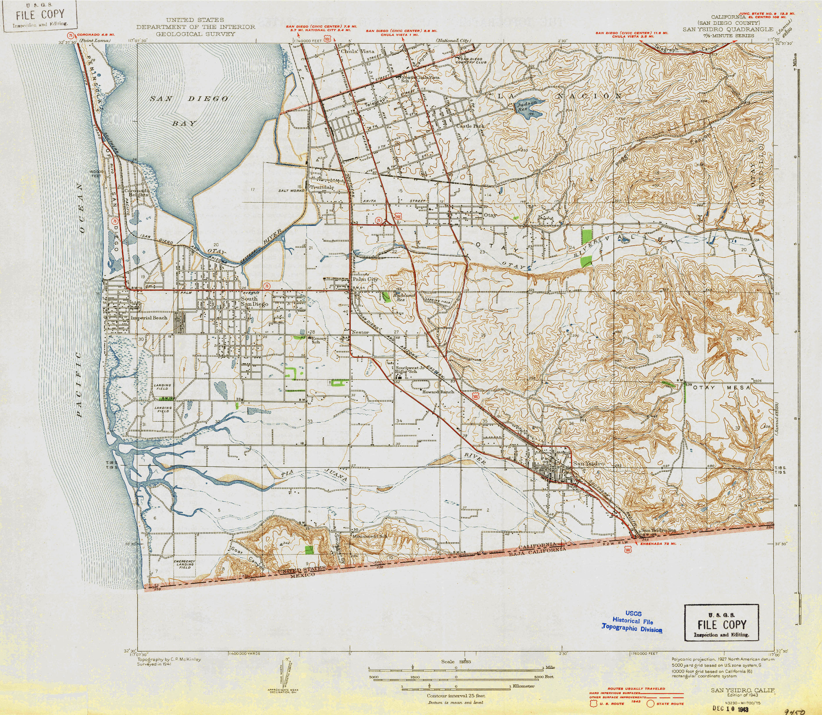
External links
edit- Caltrans: US 101 highway conditions
- Caltrans Traffic Conditions Map
- California Highway Patrol Traffic Incidents
- Bay Area FasTrak – includes toll information on the US 101 Express Lanes, the Golden Gate Bridge and the other Bay Area toll facilities
- Drive the 101: historical information website
- California @ AARoads.com – U.S. Route 101
- California Highways: US 101