
Nunawading station is a railway station operated by Metro Trains Melbourne on the Belgrave and Lilydale lines, which are part of the Melbourne rail network. It serves the eastern suburb of the same name. It was opened on 4 June 1888, with the current station being provided in 2010.[4]
Nunawading | |||||||||||||||||||||||||||||||||||||||||||||||||||||||||||||||||||||||||||||
|---|---|---|---|---|---|---|---|---|---|---|---|---|---|---|---|---|---|---|---|---|---|---|---|---|---|---|---|---|---|---|---|---|---|---|---|---|---|---|---|---|---|---|---|---|---|---|---|---|---|---|---|---|---|---|---|---|---|---|---|---|---|---|---|---|---|---|---|---|---|---|---|---|---|---|---|---|---|
 Westbound view from Platform 1, October 2025 | |||||||||||||||||||||||||||||||||||||||||||||||||||||||||||||||||||||||||||||
| General information | |||||||||||||||||||||||||||||||||||||||||||||||||||||||||||||||||||||||||||||
| Location | Springvale Road, Nunawading, Victoria 3131 City of Whitehorse Australia | ||||||||||||||||||||||||||||||||||||||||||||||||||||||||||||||||||||||||||||
| Coordinates | 37°49′13″S 145°10′38″E / 37.8204°S 145.1771°E | ||||||||||||||||||||||||||||||||||||||||||||||||||||||||||||||||||||||||||||
| System | PTV commuter rail station | ||||||||||||||||||||||||||||||||||||||||||||||||||||||||||||||||||||||||||||
| Owned by | VicTrack | ||||||||||||||||||||||||||||||||||||||||||||||||||||||||||||||||||||||||||||
| Operated by | Metro Trains | ||||||||||||||||||||||||||||||||||||||||||||||||||||||||||||||||||||||||||||
| Lines | |||||||||||||||||||||||||||||||||||||||||||||||||||||||||||||||||||||||||||||
| Distance | 20.80 kilometres from Southern Cross | ||||||||||||||||||||||||||||||||||||||||||||||||||||||||||||||||||||||||||||
| Platforms | 2 (island) | ||||||||||||||||||||||||||||||||||||||||||||||||||||||||||||||||||||||||||||
| Tracks | 2 | ||||||||||||||||||||||||||||||||||||||||||||||||||||||||||||||||||||||||||||
| Connections |  Bus Bus | ||||||||||||||||||||||||||||||||||||||||||||||||||||||||||||||||||||||||||||
| Construction | |||||||||||||||||||||||||||||||||||||||||||||||||||||||||||||||||||||||||||||
| Structure type | Cutting | ||||||||||||||||||||||||||||||||||||||||||||||||||||||||||||||||||||||||||||
| Depth | 8 metres | ||||||||||||||||||||||||||||||||||||||||||||||||||||||||||||||||||||||||||||
| Parking | Yes | ||||||||||||||||||||||||||||||||||||||||||||||||||||||||||||||||||||||||||||
| Cycle facilities | Yes | ||||||||||||||||||||||||||||||||||||||||||||||||||||||||||||||||||||||||||||
| Accessible | Yes | ||||||||||||||||||||||||||||||||||||||||||||||||||||||||||||||||||||||||||||
| Other information | |||||||||||||||||||||||||||||||||||||||||||||||||||||||||||||||||||||||||||||
| Status | Operational, premium station | ||||||||||||||||||||||||||||||||||||||||||||||||||||||||||||||||||||||||||||
| Station code | NWG | ||||||||||||||||||||||||||||||||||||||||||||||||||||||||||||||||||||||||||||
| Fare zone | Myki Zone 2 | ||||||||||||||||||||||||||||||||||||||||||||||||||||||||||||||||||||||||||||
| Website | Public Transport Victoria | ||||||||||||||||||||||||||||||||||||||||||||||||||||||||||||||||||||||||||||
| History | |||||||||||||||||||||||||||||||||||||||||||||||||||||||||||||||||||||||||||||
| Opened | 4 June 1888 | ||||||||||||||||||||||||||||||||||||||||||||||||||||||||||||||||||||||||||||
| Closed | 18 December 2009 | ||||||||||||||||||||||||||||||||||||||||||||||||||||||||||||||||||||||||||||
| Rebuilt | 11 January 2010 | ||||||||||||||||||||||||||||||||||||||||||||||||||||||||||||||||||||||||||||
| Electrified | January 1923 (1500 V DC overhead) | ||||||||||||||||||||||||||||||||||||||||||||||||||||||||||||||||||||||||||||
| Previous names | Tunstall (1888–1945) | ||||||||||||||||||||||||||||||||||||||||||||||||||||||||||||||||||||||||||||
| Passengers | |||||||||||||||||||||||||||||||||||||||||||||||||||||||||||||||||||||||||||||
| 2005–2006 | 788,028[1] | ||||||||||||||||||||||||||||||||||||||||||||||||||||||||||||||||||||||||||||
| 2006–2007 | 838,503[1]  6.4% 6.4% | ||||||||||||||||||||||||||||||||||||||||||||||||||||||||||||||||||||||||||||
| 2007–2008 | 903,848[1] 7.8% | ||||||||||||||||||||||||||||||||||||||||||||||||||||||||||||||||||||||||||||
| 2008–2009 | 925,532[2] 2.4% | ||||||||||||||||||||||||||||||||||||||||||||||||||||||||||||||||||||||||||||
| 2009–2010 | 802,559[2]  13.3% 13.3% | ||||||||||||||||||||||||||||||||||||||||||||||||||||||||||||||||||||||||||||
| 2010–2011 | 813,962[2] 1.42% | ||||||||||||||||||||||||||||||||||||||||||||||||||||||||||||||||||||||||||||
| 2011–2012 | 841,240[2] 3.35% | ||||||||||||||||||||||||||||||||||||||||||||||||||||||||||||||||||||||||||||
| 2012–2013 | Not measured[2] | ||||||||||||||||||||||||||||||||||||||||||||||||||||||||||||||||||||||||||||
| 2013–2014 | 996,058[2] 18.4% | ||||||||||||||||||||||||||||||||||||||||||||||||||||||||||||||||||||||||||||
| 2014–2015 | 1,026,669[1] 3.07% | ||||||||||||||||||||||||||||||||||||||||||||||||||||||||||||||||||||||||||||
| 2015–2016 | 1,135,520[2] 10.6% | ||||||||||||||||||||||||||||||||||||||||||||||||||||||||||||||||||||||||||||
| 2016–2017 | 949,336[2] 16.4% | ||||||||||||||||||||||||||||||||||||||||||||||||||||||||||||||||||||||||||||
| 2017–2018 | 1,113,940[2] 17.34% | ||||||||||||||||||||||||||||||||||||||||||||||||||||||||||||||||||||||||||||
| 2018–2019 | 1,148,007[2] 3.06% | ||||||||||||||||||||||||||||||||||||||||||||||||||||||||||||||||||||||||||||
| 2019–2020 | 888,900[2] 22.57% | ||||||||||||||||||||||||||||||||||||||||||||||||||||||||||||||||||||||||||||
| 2020–2021 | 390,550[2] 56.1% | ||||||||||||||||||||||||||||||||||||||||||||||||||||||||||||||||||||||||||||
| 2021–2022 | 421,250[3] 7.86% | ||||||||||||||||||||||||||||||||||||||||||||||||||||||||||||||||||||||||||||
| 2022–2023 | 526,300[3] 24.94% | ||||||||||||||||||||||||||||||||||||||||||||||||||||||||||||||||||||||||||||
| 2023–2024 | 672,750[3] 27.83% | ||||||||||||||||||||||||||||||||||||||||||||||||||||||||||||||||||||||||||||
| 2024–2025 | 758,050[3] 12.68% | ||||||||||||||||||||||||||||||||||||||||||||||||||||||||||||||||||||||||||||
| Services | |||||||||||||||||||||||||||||||||||||||||||||||||||||||||||||||||||||||||||||
| |||||||||||||||||||||||||||||||||||||||||||||||||||||||||||||||||||||||||||||
| |||||||||||||||||||||||||||||||||||||||||||||||||||||||||||||||||||||||||||||
| |||||||||||||||||||||||||||||||||||||||||||||||||||||||||||||||||||||||||||||


Initially called Tunstall, the station was given its current name of Nunawading on 1 November 1945, which coincided with the creation of the City of Nunawading, formerly the Shire of Blackburn and Mitcham[5]
History
edit

Nunawading station opened almost six years after the railway line from Camberwell was extended to Lilydale.[4] Like the suburb itself, the name of the station derives from an Aboriginal word, numphawading, meaning ceremonial ground or battlefield.[6] The settlement immediately adjacent to the station was originally named after Tunstall, England, famous for its potteries.[6]
In 1956, boom barriers replaced hand-operated gates at the former Springvale Road level crossing, which was located at the up end of the station.[7]
In 1979, under the Melbourne Bicycle Strategy, the station was one of three used as trial sites for new bike lockers, which were available either for occasional, monthly, or quarterly hire.[8]
On 18 December 2009, the original ground-level station closed as part of a grade separation project to replace the Springvale Road level crossing. A new station, in a cutting west of Springvale Road, opened on 11 January 2010.[9][10][11][12]
Platforms and services
editNunawading is served by Lilydale and Belgrave line trains[13][14] and consists of an island platform with two faces located on the western side of Springvale Road, an has concourses on both sides of the road.
The main concourse, on the western side, comprises a customer service counter, an enclosed waiting room, toilets and a café. The concourse on the eastern side is linked to the platforms via an underpass under Springvale Road. Both concourses have stairs and lifts that provide access to the platforms. Both concourses have access to the Ringwood – Box Hill bike path. On the platforms, there are metal benches, vending machines, and passenger information displays. The station car park is on the corner of Laughlin Avenue and Springvale Road.
| Nunawading platform arrangement | ||||||
|---|---|---|---|---|---|---|
| Platform | Line | Destination | Via | Service Type | Notes | Source |
| 1 | Belgrave line Lilydale line |
Flinders Street | City Loop | All stations and limited express services | See City Loop for operating patterns | [15][16] |
| 2 | Belgrave line Lilydale line |
Ringwood, Mooroolbark, Lilydale, Upper Ferntree Gully, Belgrave | All stations and limited express services | [17][18] | ||
Transport links
editKinetic Melbourne operates two bus routes via Nunawading station, under contract to Public Transport Victoria:
- 273 : to The Pines Shopping Centre[19]
- SmartBus 902 : Chelsea station – Westfield Airport West[20]
Ventura Bus Lines operates one route to and from Nunawading station, under contract to Public Transport Victoria:
- 735 : to Box Hill station[21]
Gallery
edit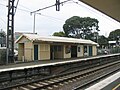 Former ground-level Platform 2 building prior to demolition, September 2005
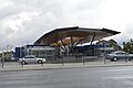 Station concourse and entrance, May 2014


References
edit- 1 2 3 4 Estimated Annual Patronage by Network Segment Financial Year 2005–2006 to 2018–19 Archived 17 April 2022 at the Wayback Machine Department of Transport
- 1 2 3 4 5 6 7 8 9 10 11 12 Railway station and tram stop patronage in Victoria for 2008–2021 Archived 17 December 2022 at the Wayback Machine Philip Mallis
- 1 2 3 4 Annual metropolitan train station patronage (station entries) Transport Victoria
- 1 2 "Nunawading". vicsig.net. Archived from the original on 23 April 2023. Retrieved 23 April 2023.
- ↑ "Nunawading Proclaimed A City". The Argus. Melbourne. 31 May 1945. Retrieved 28 June 2026 – via Trove.
- 1 2 "Nunawading". Victorian Places. Archived from the original on 2 December 2022. Retrieved 5 January 2023.
- ↑ Sinnatt, John (January 1990). "Level Crossing Protection". Somersault. Signalling Record Society Victoria. pp. 9–17.
- ↑ Network, Railways of Australia, September 1979, Vol.16 No.7 p.28
- ↑ Metlink: Closure of Nunawading Station from 8pm on Friday 18 December
- ↑ Lucas, Clay (16 September 2008). "Notorious crossing to be removed". The Age. Archived from the original on 18 September 2008. Retrieved 16 September 2008.
- ↑ "Springvale Road Rail Project". vicsig.net. Archived from the original on 1 May 2023. Retrieved 23 April 2023.
- ↑ "Springvale road and rail grade separation". Arup. Archived from the original on 11 March 2013. Retrieved 22 July 2013.
- ↑ "Lilydale Line". Public Transport Victoria.
- ↑ "Belgrave Line". Public Transport Victoria.
- ↑ "Belgrave Line". Transport Victoria. Retrieved 9 June 2026.
- ↑ "Lilydale Line". Transport Victoria. Retrieved 9 June 2026.
- ↑ "Belgrave Line". Transport Victoria. Retrieved 9 June 2026.
- ↑ "Lilydale Line". Transport Victoria. Retrieved 9 June 2026.
- ↑ "273 The Pines SC – Nunawading Station". Public Transport Victoria. Retrieved 23 April 2023.
- ↑ "902 Chelsea Railway Station – Airport West Shopping Centre (SMARTBUS Service)". Public Transport Victoria. Archived from the original on 23 April 2023. Retrieved 23 April 2023.
- ↑ "735 Box Hill to Nunawading". Public Transport Victoria.
External links
edit Media related to Nunawading railway station, Melbourne at Wikimedia Commons
- Melway map at street-directory.com.au
