
.JPG)

_(cropped).jpg)
As the historical primate city of what is now Argentina, the history of Buenos Aires has largely paralleled the history of the country as a whole. The current capital of Argentina has the distinction of having been founded twice, the first time by Pedro de Mendoza in 1536. This small and precarious settlement, beset from the outset by severe food shortages and conflict with the surrounding indigenous groups, was abandoned and destroyed only five years later, when its inhabitants fled to Asunción (in present-day Paraguay). From Asunción departed, in 1580, an expedition led by Juan de Garay, sent to carry out the second and definitive foundation of Buenos Aires. During its first two centuries of existence, the settlement was little more than a small and impoverished village on the fringes of the Spanish Empire, barred from trading freely through its port, which gave rise to a thriving contraband trade.
Pre-Hispanic indigenous presence
edit.jpg)
Although there was never a permanent indigenous settlement on the shores of the Río de la Plata, the vast Pampas grasslands within which Buenos Aires was founded had been inhabited for millennia by several local ethnic groups, which at the time of the arrival of the Europeans included the Querandí, Guaraní, Chaná and Mbeguá, among others.[1] As noted by Daniel Schavelzon: "Even though the Spaniards always considered the territory as a desierto—desert is the word that was used to define the hinterlands until the end of the 19th century—the territory in fact had other owners, namely, the natives."[2] The indigenous peoples who inhabited the Pampas plains were small groups of a few dozen individuals, led by chiefs with limited authority.[1] They were basically nomadic hunter-gatherers from the beginning of human occupation of the region (approximately 14,000 years ago) until the 15th century.[1] Small-scale agriculture could only be found in the area of the Paraná Delta (a few dozen kilometers from present-day Buenos Aires) and, since at least two millennia before the conquest, fishing had acquired a central role on the coasts of the Paraná-Plata, the Salado and the Colorado rivers, especially seasonally.[1] The original dwellers of the current territory of the city were specifically the Querandí, of which controversies persist regarding their actual population and ethnic composition.[2] The explorer Ulrich Schmidl, who was part of the first founding of Buenos Aires in 1536, wrote in his chronicles that the land where they settled belonged to the Querandí.[3] According to Schmidl, these people "'wandered all over the land, like gypsies do in German countries,' drank deer's blood in times of drought [and] their women covered their 'private parts with a cotton cloth'."[3]

Due to the intermittent occupation of the area, pre-Hispanic artifacts have been found within the city of Buenos Aires on very few occasions.[4] In 2014, the only documented pre-Hispanic archaeological site within the city was discovered by chance during a search for remains of the first Spanish settlements in the area, located in the south-west of the city on a low loessic hill about 300 metres from the old course of the Matanza–Riachuelo river, between the Ribera Sur Park and the Autódromo Oscar y Juan Gálvez.[5][6][7] Systematic excavations have exposed a late Holocene occupation surface, as thermoluminescence and radiocarbon analyses of ceramics indicate continuous or recurrent use of the site between roughly 1190 and 1536 CE, with mean ages around 800 years ago, placing the occupation several centuries before the Spanish colonisation of the area.[6][7] The La Noria site was not a permanent village but rather one or more seasonal base camps of "Pampean ceramolithic hunter-gatherers" who established temporary camps during spring and early summer on elevated ground overlooking the floodplain wetlands of the estuarine plain.[7] Excavations have recovered hundreds of ceramic sherds from cooking and serving vessels, lithic artefacts manufactured mainly from quartzites and silcretised limestones sourced in the Tandilia region and Uruguay, faunal remains dominated by pampas deer alongside guanaco, rhea and other mammals, as well as small pendants made on bone and shell, indicating a hunting-focused economy with boiling technologies and long-distance exchange networks but little use of local fish or estuarine resources despite the nearby wetlands.[7] La Noria has been highlighted by researchers and heritage advocates as an exceptional in situ testimony to the presence of indigenous peoples in what is now the city of Buenos Aires, challenging narratives that present the city as beginning with European settlement and underpinning proposals to create an archaeological interpretation centre on the site to make this pre-Hispanic past visible to the public.[5][6]

The available sources suggest that when the Spanish arrived at the Río de la Plata basin in the 16th century, there was a complex and volatile political landscape of native nations, who lived in diverse states of alliance and animosity.[8] According to Schavelzon, the city was established in an area that functioned as a frontier and point of contact between different indigenous cultures, mainly between the southern Guaraní and the so-called Pampa indians to the west, as well as other smaller groups such as the Chaná.[4] Schavelzon noted that they "would all share that area during the summer season to catch fish (...); when harvesttime came they would go away, leaving the Spaniards on their own. Even though their agricultural bases were unimportant, they did cultivate the fields, particularly with corn (maize). They were not nomadic like the Spaniards believed, but they moved along preestablished circuits depending on resources and on the seasons."[4] It is estimated that the local population in the Pampas region at the time of the conquest amounted to 55,000 people, while in the Paraná Delta to 10,000 and that Guaraní groups altogether could have amounted to 33,000 people.[4] The arrival of the Spanish produced a great dispersion of the native peoples, who escaped the confrontations and forced labor imposed by the conquistadors, to the extent that by the 17th century the "few Querandíes left were almost a curiosity".[4] As a result, the Guaraní in the neighboring northern region remained closely linked to the history of Buenos Aires and the Spanish until the 19th century, while the Pampa peoples maintained their distance and freedom through a continuous and relentless series of armed confrontations.[9]
The so-called Pampas indians were identified, from the 17th century onward, as the indigenous groups of the Pampean region who inhabited the campañas—the rural hinterlands surrounding the city of Buenos Aires—which were distinguished from another group known as the Serranos, who lived beyond the Pampas plains in upland regions that included parts of present-day San Luis and Córdoba, although this geographic criterion of distinction later became more complex as different classifications and ethnonyms came into use.[10] It has been suggested that the indigenous groups collectively labeled as "Pampas Indians" in later colonial sources were, in fact, the historical continuators of the Querandí and Guaraní peoples recorded during the early period of the conquest of Buenos Aires—a continuity supported, in part, by 17th-century lists of chiefs and their followers entrusted to the city.[10]
https://sedici.unlp.edu.ar/handle/10915/126923
https://library.si.edu/digital-library/book/losquerandesbrev00oute
1514–1580: Founding and destruction of the first Buenos Aires
edit
The first European explorers to arrive at the Río de la Plata were part of naval expeditions sent to the South Atlantic to survey the territory and look for a passage by water to the Pacific Ocean that would open a new spice trade route with the East Indies.[12][11] The first, albeit little-studied, precedent was the voyage of João de Lisboa and Estêvão Fróis in the service of the Kingdom of Portugal, during which they ventured into the Río de la Plata in July 1514, leaving written descriptions of "many good rivers" (probably the mouths of the Uruguay and Paraná rivers) and of their contact with the indigenous people of the region.[11][13] In 1514, the Crown of Castile appointed the chief pilot Juan Díaz de Solís to survey the cartography of the southern coast of the Americas in order to establish clear agreements with the Portuguese Empire.[14] Solís arrived and entered the present-day Río de la Plata, which he named Mar Dulce (Spanish for "freshwater sea").[14] In 1516, after the death of Solís, some members of the expedition managed to return to Spain, and based on their reports, the Mar Dulce received the name of Río de Solís (meaning "Solís river").[14] Two years later, the Venetian explorer Sebastian Cabot was appointed as Solís' successor when he accepted the position of chief pilot of the Crown of Castile, and in 1526 he undertook an expedition that returned to the Río de la Plata.[14] Cabot's contact with survivors of the Solís expedition in the area, who had managed to integrate into indigenous communities, as well as rumors of the travels of Aleixo Garcia, another castaway, gave rise to the Sierra de la Plata legend (Spanish for "mountain of silver"), an alleged mountain rich in silver that could be reached by going up the Paraná River.[15] The idea of the existence of this great source of silver was the driving force behind the following expeditions to the Río de la Plata, which by 1536 had already been given this name in reference to the legend,[16] meaning "river of silver" or "silver river" in Spanish and sometimes translated to English as River Plate.[17]


https://web.archive.org/web/20220121051711id_/https://journals.openedition.org/nuevomundo/59287
 The Monument to Pedro de Mendoza in Parque Lezama, in the vicinity where in 1536 he founded the first Buenos Aires.
 A map of southern South America made by Ignazio Danti c. 1570, featuring the Río de la Plata and Sancti Spiritu in the upper right.


1580–1776: Second founding and first two centuries of existence
edit
During its first two centuries of existence, Buenos Aires was barely a small, impoverished village.[18] A few years after its founding, a royal accountant described it as "the poorest city in the Indies".[19]
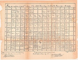 Original plan of the city projected by Juan de Garay in 1580, with the typical Spanish colonial grid pattern.
 View of Buenos Aires from the Río de la Plata, painted by an anonymous Dutch sailor c. 1628.
 View of Buenos Aires from the Río de la Plata as depicted by F. da Silva in 1734.
 Buenos Aires as depicted by Florian Baucke in 1749.
.jpg)
1776–1820: From colonial capital to revolutionary capital
edit
The creation of the Viceroyalty of the Río de la Plata and the designation of Buenos Aires as its capital profoundly impacted the history of the city and the entire region.[20] Buenos Aires, until then a bustling and growing trading village, added to its predictable commercial expansion by becoming a seat of political power, despite lacking a nobility, an audiencia, or the kind of established bureaucratic tradition found in Mexico City or Lima.[20] Pedro de Cevallos, who had previously served as Governor of Buenos Aires, was appointed as the first viceroy and that same year arrived from Spain to the Banda Oriental (transl. Eastern Bank; the area on the other side of the Río de la Plata that is currently Uruguay) at the head of an army with which he secured Spanish control of the territory after confronting the Portuguese.[20] Cevallos's victorious expedition proved advantageous for the newly designated capital of Buenos Aires, as it was accomplished without requiring a massive mobilization of the city's men and resources, unlike previous campaigns, and because the goods seized from the plundered and recaptured Colonia del Sacramento were granted to the city.[21] The city benefited once again in 1778, when it was granted permission to engage in commercial exchanges with any other port in Spain or Spanish America, leading to an uninterrupted flourishing of trade.[20] Confirming its growing importance, in 1782 the city became the seat of the Royal Audiencia of Buenos Aires, establishing itself as the center of the region's highest court of justice.[20] This development was accompanied by significant population growth, going from 24,000 residents in 1778 to at least 45,000 by 1810, with some modern estimates suggesting as many as 60,000, thereby ranking as the second largest urban center in Spanish South America after Lima.[20]

By the late 18th century, Buenos Aires displayed what historian Tulio Halperín Donghi described as a society "less renewed than its economy", in which marked commercial dynamism coexisted with the dominant groups' efforts to preserve Baroque-era mechanisms of social distinction that were increasingly ill-suited to a city on the periphery of the Spanish colonial world.[22] Although Buenos Aires society was undergoing steady renewal, with relatively open avenues for social mobility and a certain bourgeois character, it remained far from abandoning the patriarchal, class-based and corporate values that continued to structure social life.[22]
The city's urban landscape remained modest and low-lying, with only the church towers rising above the monotony of the surrounding buildings.[20] However, several streets began to be paved and illuminated at night, a royal college and a number of schools were established, and La Ranchería theater—founded in 1778—was built, only to be destroyed by fire in 1792.[20] In the early 1790s, construction was completed on a new residence for the viceroys within the fort, on the interior of the Cathedral, and on a bullring in the Monserrat district, which operated until the opening of the larger Retiro bullring, an important Mudejar-style structure inaugurated in 1801.[20] In 1803, the city's most imposing architectural feature was completed: the Recova, a great arcade that bisected the Plaza Mayor.[20] The city was organized into three concentric zones, the first being the established core that extended roughly one kilometer in each direction from the Plaza Mayor.[23] The elite resided around this central square, particularly to the south, while in other neighborhoods middle-class residents lived alongside members of the lower classes.[23] Most houses were single-story structures arranged around internal courtyards; the wealthiest families occupied entire dwellings, whereas in others rooms were rented out to multiple families.[23] The second ring lay over a kilometer from the Plaza Mayor, mainly to the west, and combined built-up areas with large vacant lots.[23] Over the following decades, the city gradually expanded into these modest neighborhoods.[23] The third ring was suburban and largely rural, where farms supplied fruits and vegetables, and where slaughterhouses, corrals and the port at the mouth of the Riachuelo were located.[23]
This period was thus marked by the growing prosperity and prominence of Buenos Aires as a city, which was further enhanced by the military fortunes gained during the English invasions of 1806 and 1807.[20]
 A well-off couple of Spaniards from Buenos Aires dressed in the fashionable majo style, painted by an anonymous traveler c. 1784–1806.
 View of the city from the southern shore of the Río de la Plata, painted by Fernando Brambila in 1794.
 Map of the city by Martín Boneo y Villalonga, 1801.
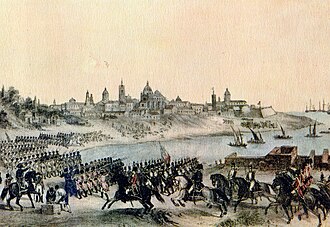 The siege of Buenos Aires during the British invasions of 1806.
 The open cabildo of 22 May 1810 during the May Revolution, as depicted by Pedro Subercaseaux in 1908.
 The Cabildo and present-day Plaza de Mayo as seen from the now-demolished Recova building, as depicted by Emeric Essex Vidal in 1817.


.jpg)
1820-1880: From provincial capital to federalized city
edit
 The funeral procession carrying Manuel Dorrego's body with the Metropolitan Cathedral in the background, 1829.
 View of the present-day Plaza de Mayo as depicted by Charles Pellegrini in 1831.
 The wagon market of the now-defunct Plaza Monserrat in the neighborhood of the same name, as depicted by Carlos Morel in 1840.
 View of Buenos Aires painted by Jean-Baptiste Henri Durand-Brager in 1841.
 Present-day Plaza de Mayo during the Fiestas Mayas, annual celebrations commemorating the May Revolution, as depicted by Charles Pellegrini in 1841.
 View of the city c. 1860 featuring the Aduana de Taylor building, later demolished in 1894.
 A typical scene on a street corner in Buenos Aires, painted by Prilidiano Pueyrredón in 1865.
 An episode of yellow fever in Buenos Aires as depicted by Juan Manuel Blanes in 1871.


1880-1955: Transformation into a modern metropolis
edit Insurgents in a building in the city center during the Revolution of the Park, July 1890.
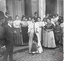 Protesters during the tenants' strike of 1907.
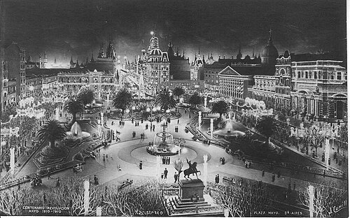 An illuminated Plaza de Mayo during the 1910 Argentina Centennial celebrations.
 Residents at the Immigrants' Hotel in 1910.
 The port as seen from the Customs House, 1915.
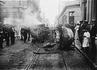 Photograph taken in the city center during the Tragic Week of 1919.
 Act from a revista porteña, the widely popular local style of revue, in the 1920s.
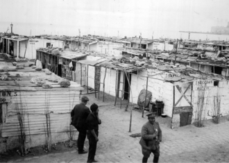
 View of the Comega Building on the corner of Alem and Corrientes streets, with the Safico Building in the back, c. 1930s.
 Aerial view of the inauguration of the Obelisco in 1936.
 The intersection of Corrientes and Florida streets in 1936.
 View of the city center to the north photographed by Horacio Coppola in 1936.
 The massive demonstration on 17 October 1945 demanding the release of Juan Perón, a foundational moment for the Peronist movement.
 The death of Eva Perón in 1952 led to a series of large commemorative marches in the city.


.jpg)


.jpg)


1955-2001
edit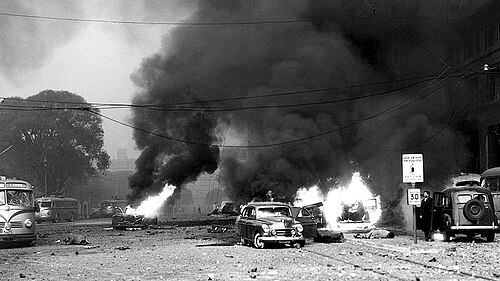 Destruction and victims during the bombing of Plaza de Mayo in 1955, the only air raid ever carried out on the city and the largest terrorist attack in the Argentina's history.
 Marta Minujín in La Menesunda, her and Rubén Santantonín's famous installation presented at the Di Tella Institute in 1965.
 View of the bar La Cueva c. 1965, one of the birthplaces of the rock nacional movement.
 View of the downtown Bar Moderno c. 1968, epicenter of the cosmopolitan and artistic youth of the time.
 View of the Palace of the Congress during the inauguration of Héctor José Cámpora, 25 May 1973.


.jpg)

2001-present
editSee also
editReferences
edit- 1 2 3 4 Otero 2012, p. 213.
- 1 2 Schavelzon 2002, p. 19.
- 1 2 Campetella 2008, p. 38.
- 1 2 3 4 5 Schavelzon 2002, p. 20.
- 1 2 Romero, Nicolás (28 October 2018). "Pueblo originario en la ciudad". Página/12 (in Spanish). Buenos Aires. Retrieved 30 November 2025.
- 1 2 3 Ini, Natalí (26 July 2019). "Revelan cómo vivían hace 800 años los habitantes prehispánicos de Buenos Aires". La Nación (in Spanish). Buenos Aires. Retrieved 30 November 2025.
- 1 2 3 4 Camino, Ulises; Schavelzon, Daniel; Azkárate, Agustín; Loponte, Daniel; Solaun, José Luis; Martínez, Angel; Sánchez, Iban; Cavallotto, José Luis (2018). "El sitio prehispánico La Noria, ciudad de Buenos Aires" (PDF). Revista de Antropología del Museo de Entre Ríos (in Spanish). 4 (2). Paraná: 84–110. ISSN 2347-033X. Archived from the original (PDF) on 30 April 2024. Retrieved 30 November 2025 – via CONICET.
- ↑ Campetella 2008, pp. 31–32.
- ↑ Schavelzon 2002, pp. 20–23.
- 1 2 Vollweiler, Sabrina Lorena (2020). "Nombres y rótulos étnicos en la región pampeana durante la segunda mitad del siglo XVII". Memoria Americana. Cuadernos de Etnohistoria (in Spanish). 28 (1). Buenos Aires: University of Buenos Aires: 42–58. ISSN 0327-5752. Retrieved 30 November 2025.
- 1 2 3 Apolinaire, Eduardo; Bastourre, Laura (2016). "Los documentos históricos de los primeros momentos de la conquista del Río de la Plata (siglos XVI-XVII): una síntesis etnohistórica comparativa" (PDF). Relaciones de la Sociedad Argentina de Antropología (in Spanish). XLI (2). Buenos Aires: Sociedad Argentina de Antropología: 319–351. ISSN 0325-2221. Retrieved 27 October 2025 – via CONICET.
- ↑ Fradkin 2012, p. 59.
- ↑ Politis, Gustavo (2014). "Las implicancias arqueológicas del Diario de Pero Lopes de Sousa (1531) durante su viaje al Río de la Plata y al Delta Inferior del Río Paraná". Revista del Museo de Antropología. 2 (7). Córdoba: Universidad Nacional de Cordoba: 317–326. doi:10.31048/1852.4826.v7.n2.9182. ISSN 1852-4826. Retrieved 29 October 2025 – via ResearchGate.
- 1 2 3 4 Fradkin 2012, p. 60.
- ↑ Fradkin 2012, pp. 60–61.
- ↑ Fradkin 2012, p. 61.
- ↑ Bulletin of the Pan American Union. Vol. 41. Washington, D. C.: Pan American Union. 1915. p. 663. Retrieved 16 March 2025 – via Google Books.
- ↑ Petrina 1998, p. 7.
- ↑ Luna 2006, p. 15.
- 1 2 3 4 5 6 7 8 9 10 11 Fradkin 2012, p. 276.
- ↑ Fradkin 2012, pp. 276–277.
- 1 2 Fradkin & Gelman 2015, p. 30.
- 1 2 3 4 5 6 Fradkin 2012, p. 277.
Bibliography
edit- Barreneche, Osvaldo, ed. (2014). Historia de la provincia de Buenos Aires: tomo 5. Del primer peronismo a la crisis de 2001 (PDF) (in Spanish). Buenos Aires: UNIPE: Editorial Universitaria; Edhasa. ISBN 978-987-628-304-5. Retrieved 15 August 2024 – via CLACSO.
- Campetella, María Andrea (2008). At the periphery of empire: Indians and settlers in the Pampas of Buenos Aires, 1580-1776 (PhD thesis). New Brunswick Rutgers, The State University of New Jersey. doi:10.7282/T3HX1D29. Retrieved 15 August 2024.
- Fradkin, Raúl O., ed. (2012). Historia de la provincia de Buenos Aires: tomo 2. De la Conquista a la crisis de 1820 (PDF) (in Spanish). Buenos Aires: UNIPE: Editorial Universitaria; Edhasa. ISBN 978-987-628-163-8. Retrieved 24 March 2024 – via CLACSO.
- Fradkin, Raúl O.; Gelman, Jorge (2015). Juan Manuel de Rosas. La construcción de un liderazgo político (in Spanish). Buenos Aires: Edhasa. ISBN 978-987-628-359-5.
- Lattes, Alfredo E., ed. (2010). Dinámica de una ciudad: Buenos Aires 1810-2010 (PDF) (in Spanish). Buenos Aires: Dirección General de Estadística y Censos. Gobierno de la Ciudad de Buenos Aires. ISBN 978-987-1037-95-7. Retrieved 10 November 2025.
- Luna, Félix (2006) [1993]. Breve historia de los Argentinos (in Spanish). Buenos Aires: Planeta. ISBN 950-49-1487-X. Retrieved 13 November 2025 – via Internet Archive.
- Palacio, Juan Manuel, ed. (2013). Historia de la provincia de Buenos Aires: tomo 4. De la federalización de Buenos Aires al advenimiento del peronismo: 1880-1943 (PDF) (in Spanish). Buenos Aires: UNIPE: Editorial Universitaria; Edhasa. ISBN 978-987-628-268-0. Retrieved 15 August 2024 – via CLACSO.
- Petrina, Alberto, ed. (1998). Buenos Aires. Guía de arquitectura. Ocho recorridos por la ciudad (PDF) (in Spanish) (2nd ed.). Buenos Aires; Seville: Gobierno de la Ciudad de Buenos Aires; Junta de Andalusia. ISBN 84-8095-158-3. Retrieved 10 August 2024.
- Otero, Hernán, ed. (2012). Historia de la provincia de Buenos Aires: tomo 1. Población, ambiente y territorio (PDF) (in Spanish). Buenos Aires: UNIPE: Editorial Universitaria; Edhasa. ISBN 978-987-628-162-1. Retrieved 24 March 2024 – via CLACSO.
- Schavelzon, Daniel (2002). The Historical Archaeology of Buenos Aires: A City at the End of the World (PDF). Translated by Alex Lomonaco. Kluwer Academic Publishers. ISBN 0-306-46064-5. Retrieved 15 August 2024.
- Ternavasio, Marcela, ed. (2013). Historia de la provincia de Buenos Aires: tomo 3. De la organización provincial a la federalización de Buenos Aires: 1821-1880 (PDF) (in Spanish). Buenos Aires: UNIPE: Editorial Universitaria; Edhasa. ISBN 978-987-628-217-8. Retrieved 15 August 2024 – via CLACSO.
- Vitalli, Olga; Pando, Horacio J. (1999). Historia del Río de la Plata (PDF) (in Spanish). Buenos Aires: Instituto de Arte Americano e Investigaciones Estéticas, FADU, University of Buenos Aires. Retrieved 7 September 2024.
External links
edit Media related to the history of Buenos Aires at Wikimedia Commons