You can help expand this article with text translated from the corresponding article in Ukrainian. (March 2025) Click [show] for important translation instructions.
|
Smila (Ukrainian: Сміла [ˈs⁽ʲ⁾milɐ] ⓘ) is a city located on Dnieper Upland near the Tyasmyn River, in Cherkasy Raion, Cherkasy Oblast of Ukraine.[3] The Tiasmyn River, a tributary of the Dnieper River, flows through the city.[4][5] In January 2022, the estimated population was 65,675.
Smila
Сміла | |
|---|---|
 The Cathedral of the Intercession of the Theotokos | |
 Flag  Coat of arms | |
 Smila Location of Smila  Smila Smila (Ukraine) | |
| Coordinates: 49°14′01″N 31°52′56″E / 49.23361°N 31.88222°E | |
| Country | |
| Oblast | Cherkasy Oblast |
| Raion | Cherkasy Raion |
| Hromada | Smila urban hromada |
| Founded | 1542 |
| City status | 1926 |
| Government | |
| • Mayor | Mr. Serhiy Ananko |
| Area | |
| • Land | 39.85 km2 (15.39 sq mi) |
| Elevation | 101 m (331 ft) |
| Population (2022) | |
• Total | 65,675 |
| 66,481 | |
| • Density | 1,648/km2 (4,268/sq mi) |
| [2] | |
| Time zone | UTC+2 (EET) |
| • Summer (DST) | UTC+3 (EEST) |
| Postal code | 20700 |
| Area code | +380 4733 |
| Sister cities | Bahacheve, Irpin, Jonava, Kovel, Newton, Vadul lui Vodă |
| Website | smila-rada |
Geography
editPopulation
edit| 1845 | 1860 | 1897 | 1926 | 1939 | 1959 | 1970 | 1979 | 1989 | 2001 | 2012 | 2021 |
|---|---|---|---|---|---|---|---|---|---|---|---|
| 8000 | 12 600 | 15 200 | 23 000 | 34 000 | 44 534 | 55 474 | 62 282 | 79 449 | 69 681 | 68 667 | 66,475 |
In 1989 the population of Smila was 77,500.[5]
In January 2022, the estimated population was 65,675, a 1.2% decrease from 2021.[2]
Language
editDistribution of the population by native language according to the 2001 census:[8]
| Language | Number | Percentage |
|---|---|---|
| Ukrainian | 61 186 | 89.10% |
| Russian | 6 956 | 10.13% |
| Other[a] | 529 | 0.77% |
| Total | 68 671 | 100.00% |
| a Those who did not indicate their native language or indicated a language that was native to less than 1% of the local population. |
History
editThis section needs expansion. You can help by adding missing information. (July 2023) |
Smila arose from an early Cossack settlement founded in the late 16th century. It later came under Polish rule.[5] Under the administration of Poland it was owned by the noble Lubomirski family. In 1759 and 1760 the city and its castle were attacked and captured by haidamaks.[9]
In 1881, 1883, and 1904 there were pogroms in Smila (Smela), during which several Jews lost their lives and much Jewish property was looted or destroyed. Jews had settled in Smila since the 18th century and at the turn of the 20th century they made up over half the population and owned most of the shops. Only a handful of Jews remain in Smila today.[10]
The construction of the Fastiv-Znamianka railway line spurred industrial growth in Smila- in 1910, the town had 23 factories and a population of 29 000.[5]
During the Second World War, the Wehrmacht deployed Stalag 345 near Smila to hold Soviet prisoners of war. The camp was kept near Smila from early 1941 until December 1943, when the camp was moved to Zagreb.[11]
In 1957, a machine repairs factory established in 1930 was repurposed to produce new machinery. The plant produced machines for food and transportation industries, and in 1972 it employed over a thousand workers.[5]
Until 18 July 2020, Smila was designated as a city of oblast significance and served as the administrative center of Smila Raion though it did not belong to the raion. The settlements of Ploske and Irdynivka were subordinated to Smila city council. As part of the administrative reform of Ukraine, which reduced the number of raions of Cherkasy Oblast to four, the city was merged into Cherkasy Raion.[12][13]
During the Russian invasion of Ukraine, Russian air strikes started a large fire within the city in October, 2022.[14] Air raid sirens sounded in the city as early as March, 2022.[15] A nearby Ukrainian fuel depot containing 100,000 tonnes of fuel was blown up the next day.[16]
Economy
editThe economic emphasis is on mechanical engineering, and the food industry is also important.[5][17] However, the town's population has generally declined since the 1980s.[17]
Smila is the transport hub for the surrounding region. Smila is where the Kyiv–Dnipro and Odesa–Russia rail routes cross, making Smila one of the most important railway junctions in Ukraine. The large station at the junction is named after Ukraine's national poet and artist, Taras Shevchenko.
Notable people
edit- Samuel (Shmuel) Malavsky – сantor.
- Oleksandr Kovpak – football player.
- Genia Averbuch – architect.
Twin towns – sister cities
editSmila is twinned with:[18][19]
 Bahacheve, Ukraine
- Irpin, Ukraine
 Jonava, Lithuania
- Kovel, Ukraine
 Newton, Iowa, United States
 Vadul lui Vodă, Moldova
Gallery
edit Female gymnasium building
 Assumption Church
 Church of the Holy Virgin
 Museum of Local History
 Technical Institute for Sugar Industry
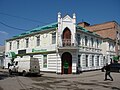 Bank building
 Shevchenko district
 Railway station
 Railway bridge
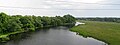 Tiasmyn River in Smila
![Nativity of Saint John the Baptist Church [uk]](http://wiki.nitrosworld.org/proxy-img/http%3A%2F%2Fupload.wikimedia.org%2Fwikipedia%2Fcommons%2Fthumb%2F5%2F51%2F%25D0%25A5%25D1%2580%25D0%25B0%25D0%25BC_%25D0%25BD%25D0%25B0_%25D1%2587%25D0%25B5%25D1%2581%25D1%2582%25D1%258C_%25D0%25A0%25D1%2596%25D0%25B7%25D0%25B4%25D0%25B2%25D0%25B0_%25D0%2586%25D0%25BE%25D0%25B0%25D0%25BD%25D0%25BD%25D0%25B0_%25D0%25A5%25D1%2580%25D0%25B5%25D1%2581%25D1%2582%25D0%25B8%25D1%2582%25D0%25B5%25D0%25BB%25D1%258F.jpg%2F120px-%25D0%25A5%25D1%2580%25D0%25B0%25D0%25BC_%25D0%25BD%25D0%25B0_%25D1%2587%25D0%25B5%25D1%2581%25D1%2582%25D1%258C_%25D0%25A0%25D1%2596%25D0%25B7%25D0%25B4%25D0%25B2%25D0%25B0_%25D0%2586%25D0%25BE%25D0%25B0%25D0%25BD%25D0%25BD%25D0%25B0_%25D0%25A5%25D1%2580%25D0%25B5%25D1%2581%25D1%2582%25D0%25B8%25D1%2582%25D0%25B5%25D0%25BB%25D1%258F.jpg)


_01.JPG)


![Nativity of Saint John the Baptist Church [uk]](http://wiki.nitrosworld.org/wiki/File:Храм_на_честь_Різдва_Іоанна_Хрестителя.jpg)
References
edit- ↑ "Смілянська міська територіальна громада" [Smila Urban Territorial Community] (PDF) (in Ukrainian). Archived from the original (PDF) on 2024-04-19.
- 1 2 Чисельність населення в місті Сміла [Population in the city of Smila]. index.minfin.com.ua (in Ukrainian). Retrieved 2023-07-04.
- ↑ "Смілянська територіальна громада" (in Ukrainian). decentralization.gov.ua.
- ↑ "Сміла".
{{cite web}}: CS1 maint: deprecated archival service (link) - 1 2 3 4 5 6 Struk, Danylo Husar (1993-12-15). Encyclopedia of Ukraine: Volume IV: Ph-Sr. University of Toronto Press. ISBN 978-1-4426-5126-5.
- ↑ "Smila Climate, Weather By Month, Average Temperature (Ukraine) - Weather Spark". weatherspark.com. Retrieved 2026-06-05.
- ↑ "Simulated historical climate & weather data for Smila". meteoblue. Retrieved 2026-06-05.
- ↑ "Рідні мови в об'єднаних територіальних громадах України" (in Ukrainian).
- ↑ Архів Коша Нової Запорозької Січі. Опис справ 1713-1776. Наукова думка. 1994. p. 64. ISBN 5120026745.
- ↑ History of Jewish Communities in Ukraine. https://jewua.org/smela/. 2019. Retrieved 7 October 2025.
- ↑ Megargee, Geoffrey P.; Hecker, Mel (2022-04-26). The United States Holocaust Memorial Museum Encyclopedia of Camps and Ghettos, 1933–1945, Volume IV: Camps and Other Detention Facilities Under the German Armed Forces. Indiana University Press. ISBN 978-0-253-06090-7.
- ↑ "Про утворення та ліквідацію районів. Постанова Верховної Ради України № 807-ІХ". Голос України (in Ukrainian). 2020-07-18. Retrieved 2020-10-03.
- ↑ "Нові райони: карти + склад" (in Ukrainian). Міністерство розвитку громад та територій України. 17 July 2020.
- ↑ "Power outages reported across Ukraine after latest Russian rocket attacks". UPI. Retrieved 2022-12-31.
- ↑ "Russia's invasion of Ukraine: List of key events from day 20". www.aljazeera.com. Retrieved 2023-07-04.
- ↑ "Russia's defence minister warns of 'uncontrolled escalation' in Ukraine conflict". France 24. 2022-10-23. Retrieved 2023-07-04.
- 1 2 Cybriwsky, Roman Adrian (2018-03-15). Along Ukraine's River: A Social and Environmental History of the Dnipro. Central European University Press. ISBN 978-963-386-204-9.
- ↑ "Міста побратими". smila-rada.gov.ua. Smila. Retrieved 2024-09-28.
- ↑ "Міста побратими". vatutine-gromada.gov.ua. Bahacheve. Retrieved 2024-09-28.
- (in Ukrainian) (1972) Історія міст і сіл Української CCP - Черкаська область (History of Towns and Villages of the Ukrainian SSR - Cherkasy Oblast), Kyiv.
External links
edit- (in Ukrainian) Official city website
- (in Ukrainian) Unofficial city website