The Nærøyfjord (or Nærøyfjorden, Urban East Norwegian: [ˈnæ̂ːrœʏˌfjuːɳ]) is a fjord in Aurland Municipality in Vestland county, Norway. It is a branch of the Aurlandsfjord, itself a branch of the Sognefjord.[1] The fjord is about 17 km (11 mi) long, and at its narrowest point it is about 250 m (820 ft) wide.[2][3]
| UNESCO World Heritage Site | |
|---|---|
 Nærøyfjord | |
 Interactive map of Nærøyfjord | |
| Official name | Nærøyfjord Area |
| Location | Aurland, Norway |
| Part of | West Norwegian Fjords – Geirangerfjord and Nærøyfjord |
| Criteria | Natural: (vii)(viii) |
| Reference | 1195-002 |
| Inscription | 2005 (29th Session) |
| Area | 51,802 ha (128,010 acres) |
| Coordinates | 60°56′37″N 6°55′53″E / 60.94361°N 6.93139°E |
 Nærøyfjord Location of Nærøyfjord in Norway  Nærøyfjord Nærøyfjord (Vestland) | |
The fjord is surrounded by steep mountains that rise to about 1,761 m (5,778 ft) above sea level.[1] South of the village of Bakka, the fjord narrows to less than 500 m (1,600 ft), while the distance between the mountain summits on each side is only about 3 km (1.9 mi).[4] The village of Gudvangen lies at the inner end of the fjord, where the river Nærøydalselvi enters the fjord from the valley of Nærøydalen.[1]
Geography and physical characteristics
editNærøyfjord is one of the narrowest arms of the Sognefjord system.[1] The steep valley sides rise almost directly from the water and are cut by waterfalls and hanging valleys, features that contribute to the fjord's dramatic landscape.[5][6]
According to older topographical descriptions, the fjord is very shallow at the narrow passage near Bakka, but becomes deeper farther inward.[7] In cold winters, the fjord has occasionally frozen over. Such cases were recorded in the 1920s and in 1962, when scheduled boats were unable to enter the fjord and instead had to navigate along the ice edge.[8]
Geology
editNærøyfjord was formed by glacial erosion during the Quaternary ice ages. Large glaciers carved deep and narrow valleys into the bedrock; after the ice retreated, these valleys were inundated by seawater, creating the fjords seen today.[9][5]
UNESCO describes the West Norwegian Fjords as displaying a full range of landforms related to active Pleistocene glaciation and post-glacial uplift, with steep fjord walls exposing polished bedrock in three-dimensional cross-section.[5] The geology of the area is dominated by ancient crystalline rocks that were extensively modified by glacial processes.[9]
World Heritage status
editIn 2005, the Nærøyfjord area, together with the Geirangerfjord area, was inscribed on the UNESCO World Heritage List as part of the property West Norwegian Fjords – Geirangerfjord and Nærøyfjord.[5] UNESCO cited the property's exceptional natural beauty and its outstanding example of fjord landscape shaped by glacial processes.[5][10]
The protected area around Nærøyfjord includes the Nærøyfjorden landscape protection area and a number of associated nature reserves in the municipalities of Aurland, Voss, Vik, and Lærdal.[11][12]
Scholarly work on UNESCO management has noted that the West Norwegian Fjords, including Nærøyfjord, are primarily framed internationally as a nature and landscape heritage site rather than as a cultural heritage site. The same research also notes that, unlike some transboundary marine World Heritage properties, the site is managed by a single state, Norway, which simplifies coordination of management measures.[13]
Ecology
editThe Nærøyfjord area forms part of a well-preserved ecosystem ranging from fjord waters to alpine mountain environments.[5][12] Its altitudinal variation supports forests, meadows, alpine vegetation, and associated fauna.[12] The protected landscape also includes a cultural landscape shaped by historic farming and settlement in otherwise steep terrain.[12]
Tourism and access
editNærøyfjord is one of the best-known tourist destinations in fjord Norway.[3] Cruises, kayaking, hiking, and combined rail-and-boat itineraries are among the most common ways of visiting the fjord.[3][14][15]
The main access points are Gudvangen and Flåm.[3][15] Fjord cruises between Gudvangen and Flåm pass through both Nærøyfjord and Aurlandsfjord, while road and rail links connect the area with the wider transport network of western Norway.[14][15] Travel promotion sources also describe the route as one of the most popular fjord experiences in Norway.[6]
The fjord has also received high-profile travel recognition. National Geographic's Destinations Rated coverage placed Norway's fjords region first in one of its global rankings of destinations.[16]
Cultural significance
editHistory of study
editDescriptions of Nærøyfjord and the surrounding landscape appeared in Norwegian topographical and statistical works in the late 19th and early 20th centuries. One of the early detailed printed accounts was published by Amund Helland in the Norges land og folk series.[7]
More recent scientific and heritage literature has discussed the West Norwegian Fjords, including Nærøyfjord, as an important area for the study of Quaternary glaciation, post-glacial uplift, slope processes, and the long-term evolution of fjord landscapes.[5][9]
In popular culture
editMedia gallery
edit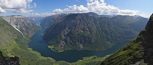 Nærøyfjorden from Bakkanosi
 Nærøyfjord with sightseeing boat
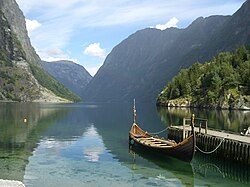 View from Gudvangen
 Gudvangen ferry
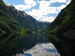 Nærøyfjord
 Nærøyfjord
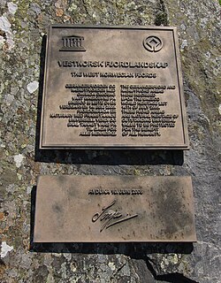 Plaquette at Bakka, signed by Queen Sonja of Norway on 10 June 2006


.jpg)

References
edit- 1 2 3 4 "Nærøyfjorden". Store norske leksikon (in Norwegian). Retrieved 2026-04-02.
- ↑ "Nærøyfjorden". Norgeskart.no (in Norwegian). Statens kartverk. Retrieved 2026-04-02.
- 1 2 3 4 "The UNESCO Nærøyfjord". Visit Norway. Retrieved 2026-04-02.
- ↑ "Bakka". Store norske leksikon (in Norwegian). Retrieved 2026-04-02.
- 1 2 3 4 5 6 7 "West Norwegian Fjords – Geirangerfjord and Nærøyfjord". UNESCO World Heritage Centre. Retrieved 2026-04-02.
- 1 2 "The Nærøyfjord". Fjord Norway. Retrieved 2026-04-02.
- 1 2 Helland, Amund (1901). Topographisk-statistisk beskrivelse over Nordre Bergenhus amt. Den almindelig del. Norges land og folk (in Norwegian).
- ↑ Førsund, Finn Borgen (1998). Dampen og kaia. Stoppestader for Fylkesbaatane i Sogn og Fjordane 1858–1998 (in Norwegian). Førde: Selja forlag.
- 1 2 3 "West Norwegian Fjords - Geologi" (PDF). Norsk Geologisk Forening. Retrieved 2026-04-02.
- ↑ "Decision 29 COM 8B.7 - West Norwegian Fjords". UNESCO World Heritage Centre. Retrieved 2026-04-02.
- 1 2 "Vestnorsk fjordlandskap". Store norske leksikon (in Norwegian). Retrieved 2026-04-02.
- 1 2 3 4 "Nærøyfjorden landskapsvernområde". Nærøyfjorden verneområdestyre (in Norwegian). Retrieved 2026-04-02.
- ↑ Kenterelidou, Clio; Galatsopoulou, Fani (2021). "Sustainable Biocultural Heritage Management and Communication: The Case of Digital Narrative for UNESCO Marine World Heritage of Outstanding Universal Value". Sustainability. 13 (3): 1–32. Bibcode:2021Sust...13.1449K. doi:10.3390/su13031449.
- 1 2 "Fjord Cruise Nærøyfjord". Fjord Norway. Retrieved 2026-04-02.
- 1 2 3 "Welcome to the West Norwegian Fjords - delområde Nærøyfjorden". Vestnorsk fjordlandskap. Retrieved 2026-04-02.
- ↑ "Photos: Best and Worst Destinations Rated". National Geographic. Retrieved 2026-04-02.
- 1 2 "Disney's Frozen: Inspired by Norway's beauty". The Globe and Mail. 26 November 2013. Retrieved 18 January 2014.
External links
edit Media related to Nærøyfjorden at Wikimedia Commons
- Nærøyfjord Website
- Official tourist information
This Vestland location article is a stub. You can help Wikipedia by adding missing information. |