Ninh Bình (Vietnamese pronunciation: [nīɲ ɓìɲ]) is a province of Vietnam in the Red River Delta region.[4] The province is known for natural and cultural attractions, including reserved parks in Cúc Phương National Park and Vân Long, grotto caves and rivers in Tràng An, Tam Cốc-Bích Động and Múa Caves, historic monuments in the Hoa Lư ancient capital, Vietnam's largest Buddhist worshipping complex (Bái Đính Temple), and the Phát Diệm Cathedral with "eclectic architectural style".
Ninh Bình | |
|---|---|
.jpg) _(37634801525).jpg) .jpg)       Bích Động valley, near Tam Cốc in Tràng An UNESCO World Heritage Site • Tràng An Scenic Landscape Complex • Phát Diệm Cathedral • Bái Đính Temple • Hoa Lư • Mountain Ngọc Mỹ Nhân • Cave Vân Trình • Cúc Phương National Park • Thung Nham | |
 Seal | |
| Nickname: Serenity | |
 Location of Ninh Bình within Vietnam | |
 Interactive map of Ninh Bình | |
| Coordinates: 20°15′N 105°50′E / 20.250°N 105.833°E | |
| Country | |
| Region | Red River Delta |
| Capital | Hoa Lư ward |
| Government | |
| • People's Council Chair | Đinh Văn Hùng |
| • People's Committee Chair | Đinh Văn Hùng |
| Area | |
• Total | 3,942.62 km2 (1,522.25 sq mi) |
| Population (2025)[1] | |
• Total | 4,412,264 |
| • Density | 1,119.12/km2 (2,898.51/sq mi) |
| Demographics | |
| • Ethnicities | Vietnamese, Mường, Tày, H'Mông |
| GDP[2] | |
| • Total | VND 47.205 trillion US$ 2.050 billion |
| Time zone | UTC+07:00 (ICT) |
| Area codes | 229 |
| ISO 3166 code | VN-18 |
| HDI (2020) | (15th) |
| Website | ninhbinh |
Geography
editNinh Bình is located to the south of the Northern Delta, between the Red and Ma rivers. It has a coastline abutting the Gulf of Tonkin.[5]
The population is 1,010,700 people (2022), with a total area of 1,412 km2 (545 mi2).[6]
Gallery
edit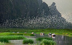
 Thung Nham Bird Park
 Limestone scenery
 Rice paddies
 Landscape near Ninh Bình
 Tam Cốc-Bích Động
 Hoa Lư - ancient capital
 Khê Hạ village and paddies


.jpg)

References
edit- 1 2 "Nghị quyết số 202/2025/QH15 của Quốc hội về việc sắp xếp đơn vị hành chính cấp tỉnh". quochoi.vn. Retrieved 2025-07-24.
- ↑ "Tình hình kinh tế, xã hội Ninh Bình năm 2018". Báo Ninh Bình, Đảng bộ tỉnh. Archived from the original on 15 October 2019. Retrieved 10 May 2020.
- ↑ "Human Development Index by province(*) by Cities, provincies and Year". General Statistics Office of Vietnam. Retrieved September 28, 2024.
- ↑ "Tổng quan Du lịch Ninh Bình". sodulich.ninhbinh.gov.vn. Retrieved 2023-11-13.
- ↑ "Điều kiện tự nhiên". ninhbinh.gov.vn. Retrieved 2023-11-13.
- ↑ Dân số Ninh Bình - Thông tin từ Tổng cục thống kê
External links
editWikimedia Commons has media related to Ninh Binh.