Kırşehir is a city in Turkey. It is the seat of Kırşehir Province and Kırşehir District.[2] Its population is 162,989 (2023).
Kırşehir | |
|---|---|
 Kentpark in Kırşehir | |
|
Coat of arms | |
 Kırşehir Location in Turkey  Kırşehir Kırşehir (Turkey Central Anatolia) | |
| Coordinates: 39°08′44″N 34°09′39″E / 39.14556°N 34.16083°E | |
| Country | Turkey |
| Province | Kırşehir |
| District | Kırşehir |
| Government | |
| • Mayor | Selahattin Ekicioğlu (CHP) |
| Elevation | 1,027 m (3,369 ft) |
| Population (2022)[1] | 150,700 |
| Time zone | UTC+3 (TRT) |
| Postal code | 40000 |
| Area code | 0386 |
| Website | www |
History
edit
The history of Kırşehir dates back to the Hittites. During the period of the Hittites, the basin of Kırşehir was known as the country of "Ahiyuva", meaning "the Land of the Achaeans", as the Greeks were known to the Hittites. This basin also took the name Cappadocia at the time of the Romans and Byzantines.
In antiquity, the settlement in the area of modern Kırşehir is identified with the ancient city of Mocissus (or Mokissós).[3] Following major reconstruction and fortification work in the 6th century during the reign of the Byzantine emperor Justinian I, the city was renamed Justinianopolis.[4][5]

Kırşehir was once known as Aquae Saravenae.[6] The Seljuks took the city in the 1070s and bestowed the current name. In Turkish, "Kır Şehri" means "steppe city" or "prairie city". It became the chief town of a sanjak in the Ottoman vilayet of Angora,[7] which possessed, c. 1912, 8,000 inhabitants, most of them Muslim Turks.[8]
In the 19th century, Kırşehir was attached to the sanjak of Ankara. From 1867 until 1922, Kırşehir was part of Angora vilayet. In 1924, Kırşehir was made capital of the new Kırşehir Province. Mustafa Kemal Atatürk visited the city in 1921 and 1931.
Historic buildings and structures
edit
.jpg)
.

Kesikköprü
editKesikköprü is one of the bridges built by the Seljuk Empire in Central Anatolia. It is on the way of Kırşehir-Konya, about 20 km (12.43 mi) to the south of Kırşehir, and across the River Kızılırmak with its 13 parts. Those who came from Izmir and tried to reach Sivas and Erzurum from Tokat passed over Kesikköprü. In the 17th and 18th centuries, the bridge took the name of Kesikköprü due to the fact that caravan roads were cut off by highwaymen.
There is an old Seljuk mosque built during the reign of either Mesud I or Kilij Arslan II. In the countryside is a ruined türbe (tomb) of a possible dervish during the times of either Seljuks or Ottomans.
The inscription on the bridge says it was built by Atabeg Izzu’d-Din Muhammed in 646 of the Hijrah/1248 of the Christian era during the rule of Keykavus, the son of Keyhüsrev. The inscription sunk in the river in 1953. The three-line inscription on the stone base can be read with difficulty:
Ressame bi-imaret hazihi el-kantara el-mubareke (fi eyyam khan) dawlet es-sultan el-azam, izzu-d dunya wa-d din, ebu'l feth Kaykaus bin Kaykhusraw Burhan emir el-mu’munin. El-mawla el-sahibu el-azam, atabek el-muazzam, nazım mesalih el-'alem, nasır el-enam, zubdet el-eyyam, Izz-eddin ebu'l meli Muhammed Zahir Ali Seljuk wa emir el-mu’minin a'azzellahu nasrahu wa a'la kadrehu fi shuhuri sene sitte wa arba'in wa sitte mia [646], hamiden li-Llah wa musallian 'ala nebiyyihi Muhammed wa aalihi wa sellem teslimen kethiran.
Ashik Pasha Mausoleum
editAşık Pasha Mausoleum is the tomb of the 14-century Sufi poet Aşık Pasha who died in 1332.[9]
Kırşehir Castle
editGeographical center of the world
edit


The village of Seyfe within Kırşehir district is considered the geographical center of Earth, as it lies at the intersection of the 39th parallel north and the 34th meridian east.[12]
Ecclesiastical history
editMetropolitan Archbishopric of Mocissus
editMocissus was also a Christian bishopric, and became a metropolitan see when, as Procopius (De ædif., V, iv) informs us, Justinian divided Cappadocia into three provinces and made this fortified site in north-western Cappadocia metropolis of Cappadocia Tertia, giving it the name of Justinianopolis.[8] Nothing else is known of its history, and its name should perhaps be written Mocessus. There is no doubt that the site of Mocissus, or Mocessus, is that which is occupied by the modern city of Kırşehir.[8] The metropolitanate was temporarily assumed by the Diocese of Caesarea in 1327, following its decline by the Anatolian Beyliks. In 1369 and in 1370 however, new metropolitans assumed Mocissus.[13]
Only a few of its bishops are known: the earliest, Peter, attended the Fifth Ecumenical Council (Second Council of Constantinople, 536);[clarification needed] the last, whose name is not known, was a Catholic, and was consecrated after the mid-15th century Catholic Council of Florence by Patriarch Metrophanes II of Constantinople.[8]
Demographics
editKırşehir is the administrative centre of Kırşehir Province and one of the principal urban settlements of Central Anatolia. The city has experienced steady population growth through rural-to-urban migration and its role as the province's administrative, educational, and economic centre.
As the largest settlement in the province, Kırşehir concentrates a significant proportion of the provincial population and serves as a regional hub for public services, commerce, and education.[14]
Economy
editThe economy of Kırşehir is based on a combination of agriculture, industry, services, and education. Historically, the surrounding region has been known for cereal cultivation and animal husbandry, which continue to contribute to the local economy.
In recent decades, manufacturing, food processing, construction materials, and small-scale industry have become increasingly important. The city also functions as a regional centre for trade and public administration, serving surrounding districts and rural communities.[15]
The presence of Ahi Evran University has further contributed to economic development by attracting students, academic staff, and related businesses.[16]
Education
editHigher education in Kırşehir is centred on Ahi Evran University, a public university named after Ahi Evran, the founder of the medieval Anatolian Ahi guild organization. The university offers programmes in engineering, medicine, agriculture, social sciences, and education.
The institution plays an important role in the city's educational, cultural, and economic life and serves students from across Central Anatolia.[17]
Culture
editKırşehir occupies an important place in the cultural history of Anatolia and is particularly associated with the traditions of the Ahi brotherhood, a medieval organization of craftsmen and merchants founded by Ahi Evran. The city remains an important centre of Ahi culture and hosts events commemorating its historical legacy.[18]
The city is also known for its contribution to Turkish folk music. Kırşehir was the home of the renowned folk poet and musician Neşet Ertaş, one of the most influential figures in the Anatolian bozlak musical tradition.[19]
Traditional folk music, storytelling, and seasonal celebrations continue to form part of the city's cultural identity.
Tourism
editTourism in Kırşehir is based on its historical heritage, thermal springs, and cultural attractions. Visitors are drawn to sites associated with the Ahi tradition, as well as monuments dating from the Seljuk and Ottoman periods.
The city is also known for its thermal tourism facilities, particularly in nearby spa areas that utilize mineral-rich thermal waters. Historical mosques, tombs, museums, and cultural centres constitute additional attractions for visitors.[20]
Transport
editKırşehir is connected to neighbouring provinces through a network of state highways linking the city with Ankara, Nevşehir, Kayseri, Aksaray, and Kırıkkale. Its central location within Anatolia has historically made it an important point along regional trade and travel routes.
Road transportation remains the principal means of access to the city, supporting both commercial activity and regional mobility.[21]
Titular see
editThe diocese was restored in 1895 as a titular archbishopric of the highest (Metropolitan) rank. It's vacant, having had the following incumbents:
- John Joseph Frederick Otto Zardetti (1895.05.25 – 1902.05.09)
- Giacomo Merizzi (1902.08.21 – 1916.03.22)
- Giovanni Battista Vinati (1916.07.31 – 1917.01.09)
- Adolf Fritzen (1919.07.31 – 1919.09.07)
- Lorenzo Schioppa (1920.08.20 – 1935.04.23)
- John Hugh MacDonald (1936.12.16 – 1938.03.05)
- Nicolas Cadi (1939.11.16 – 1941)
- Roger-Henri-Marie Beaussart (1943.12.10 – 1952.02.29)
- Vigilio Federico Dalla Zuanna, O.F.M. Cap. (1952.11.24 – 1956.03.04)
- Giovanni Jacono (1956.10.02 – 1957.05.26)
- Heinrich Wienken (1957.08.19 – 1961.01.21)
- Gabrijel Bukatko (1961.03.02 – 1964.03.24)
Climate
editKırşehir has a Mediterranean (Köppen climate classification: Csa) or continental climate (Trewartha climate classification: Dc), with cold, snowy winters and hot, dry summers. Light rainfall occurs year-round, except for late summer when rain is virtually absent.
Highest recorded temperature:40.5 °C (104.9 °F) on 14 August 2019
Lowest recorded temperature:−28.0 °C (−18.4 °F) on 6 January 1942[22]
| Climate data for Kırşehir (1991–2020, extremes 1930–2023) | |||||||||||||
|---|---|---|---|---|---|---|---|---|---|---|---|---|---|
| Month | Jan | Feb | Mar | Apr | May | Jun | Jul | Aug | Sep | Oct | Nov | Dec | Year |
| Record high °C (°F) | 19.0 (66.2) |
20.6 (69.1) |
28.0 (82.4) |
30.9 (87.6) |
34.5 (94.1) |
36.2 (97.2) |
40.2 (104.4) |
40.5 (104.9) |
39.0 (102.2) |
33.6 (92.5) |
26.2 (79.2) |
19.9 (67.8) |
40.5 (104.9) |
| Mean daily maximum °C (°F) | 4.9 (40.8) |
7.2 (45.0) |
12.2 (54.0) |
17.5 (63.5) |
22.5 (72.5) |
26.9 (80.4) |
30.7 (87.3) |
30.9 (87.6) |
26.7 (80.1) |
20.6 (69.1) |
13.0 (55.4) |
6.9 (44.4) |
18.3 (64.9) |
| Daily mean °C (°F) | 0.1 (32.2) |
1.5 (34.7) |
5.9 (42.6) |
10.8 (51.4) |
15.7 (60.3) |
20.0 (68.0) |
23.7 (74.7) |
23.9 (75.0) |
19.2 (66.6) |
13.5 (56.3) |
6.5 (43.7) |
2.1 (35.8) |
11.9 (53.4) |
| Mean daily minimum °C (°F) | −3.8 (25.2) |
−3.0 (26.6) |
0.5 (32.9) |
4.7 (40.5) |
9.2 (48.6) |
13.2 (55.8) |
16.5 (61.7) |
16.8 (62.2) |
12.1 (53.8) |
7.2 (45.0) |
1.2 (34.2) |
−1.7 (28.9) |
6.1 (43.0) |
| Record low °C (°F) | −28.0 (−18.4) |
−25.3 (−13.5) |
−21.8 (−7.2) |
−8.2 (17.2) |
−1.4 (29.5) |
2.6 (36.7) |
5.1 (41.2) |
5.0 (41.0) |
−1.2 (29.8) |
−6.6 (20.1) |
−21.5 (−6.7) |
−24.3 (−11.7) |
−28.0 (−18.4) |
| Average precipitation mm (inches) | 43.8 (1.72) |
31.2 (1.23) |
37.9 (1.49) |
42.7 (1.68) |
46.2 (1.82) |
37.5 (1.48) |
8.9 (0.35) |
11.8 (0.46) |
14.9 (0.59) |
30.6 (1.20) |
35.0 (1.38) |
44.9 (1.77) |
385.4 (15.17) |
| Average precipitation days | 12.3 | 10.53 | 11.13 | 10.97 | 12.37 | 8.03 | 2.2 | 1.83 | 3.77 | 7.1 | 8.27 | 12.7 | 101.2 |
| Average snowy days | 8.4 | 6 | 4.4 | 0.7 | 0 | 0 | 0 | 0 | 0 | 0.1 | 1.1 | 4.3 | 25 |
| Average relative humidity (%) | 79 | 73.8 | 66.7 | 62.7 | 60.6 | 54.9 | 46.9 | 46.6 | 50.5 | 61.2 | 71.1 | 79.2 | 62.8 |
| Mean monthly sunshine hours | 102.3 | 130.0 | 176.7 | 210.0 | 272.8 | 318.0 | 368.9 | 347.2 | 288.0 | 223.2 | 165.0 | 102.3 | 2,704.4 |
| Mean daily sunshine hours | 3.3 | 4.6 | 5.7 | 7.0 | 8.8 | 10.6 | 11.9 | 11.2 | 9.6 | 7.2 | 5.5 | 3.3 | 7.4 |
| Source 1: Turkish State Meteorological Service[23] | |||||||||||||
| Source 2: NCEI(humidity)[24] | |||||||||||||
Notable people
edit- Uğur Mumcu, investigative journalist
- Neşet Ertaş, Folk singer
- Lütfi Müfit Özdeş, politician
- Şemsi Yastıman, folk musician
- Nur al-Din ibn Jaja, Emir of Kırşehir from 1261 to 1277
- Asik Pasa, Ṣūfī spiritual leader, Turkish poet[25]
Gallery
edit View of Kırşehir from an airplane
 Ahi Evran Tomb front view
 Ahi Evran Tomb side view
 Apple farm in Kırşehir
 Cügün (Cogun) lake
 The ruins of the Üçayak Byzantine Church
 View of Kent Park at night
 View of the city during the day
 Winter in Hilla Park
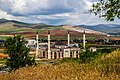 Construction of the new mosque in Özbağ in Kırşehir, Turkey
 Gondolas in Kentpark

.jpg)


Twin towns – sister cities
editReferences
edit- ↑ "Address-based population registration system (ADNKS) results dated 31 December 2022, Favorite Reports" (XLS). TÜİK. Retrieved 13 March 2023.
- ↑ İl Belediyesi Archived 2023-03-06 at the Wayback Machine, Turkey Civil Administration Departments Inventory. Retrieved 1 March 2023.
- ↑ "Mokissos". The Oxford Dictionary of Byzantium. Oxford University Press. 1991. Retrieved 5 June 2026.
- ↑ "KIRŞEHİR". TDV İslâm Ansiklopedisi. Retrieved 5 June 2026.
- ↑ Belke, Klaus; Restle, Marcell (1984). Tabula Imperii Byzantini, Band 2: Kappadokien. Österreichische Akademie der Wissenschaften.
- ↑ Lund University. Digital Atlas of the Roman Empire.
- ↑ Chisholm, Hugh, ed. (1911). . Encyclopædia Britannica. Vol. 15 (11th ed.). Cambridge University Press. p. 834.
- 1 2 3 4 Pétridès, Sophron (1911). . In Herbermann, Charles (ed.). Catholic Encyclopedia. Vol. 10. New York: Robert Appleton Company.
- ↑ Eyice, Semavi. "Âşık Paşa Türbesi" (in Turkish). İslam Ansiklopedisi. Retrieved 1 May 2020.
- ↑ T.C. Kırşehir Valiliği. "TARİHİ VE KÜLTÜREL DEĞERLER" (in Turkish). Retrieved 2023-02-14.
- ↑ Geoview. "Kırşehir Kalesi" (in Turkish). Retrieved 2023-02-14.
- ↑ Tüfekçi, İhsan (2022-12-27). "Is Türkiye Center Of The World? Where Is The Center? -". Destinations in Turkey. Retrieved 2023-07-10.
- ↑ Vryonis, Speros (1971). The Decline of Medieval Hellenism in Asia Minor and the Process of Islamisation from the Eleventh through the Fifteenth Century. Berkeley: California University Press. p. 292
- ↑ "Address-Based Population Registration System Results". Turkish Statistical Institute (TÜİK). Retrieved 7 June 2026.
- ↑ "Kırşehir Economic Profile". Kırşehir Governorship. Retrieved 7 June 2026.
- ↑ "About Ahi Evran University". Ahi Evran University. Retrieved 7 June 2026.
- ↑ "About Ahi Evran University". Ahi Evran University. Retrieved 7 June 2026.
- ↑ "Ahi Culture and Kırşehir". Kırşehir Provincial Directorate of Culture and Tourism. Retrieved 7 June 2026.
- ↑ "Neşet Ertaş". Türk Edebiyatı İsimler Sözlüğü. Retrieved 7 June 2026.
- ↑ "Places to Visit in Kırşehir". Kırşehir Provincial Directorate of Culture and Tourism. Retrieved 7 June 2026.
- ↑ "Kırşehir Geography and Transportation". Kırşehir Governorship. Retrieved 7 June 2026.
- ↑ "İllerimize Ait Genel İstatistik Verileri" (in Turkish). Turkish State Meteorological Service. Retrieved 10 July 2024.
- ↑ "Resmi İstatistikler: İllerimize Ait Mevism Normalleri (1991–2020)" (in Turkish). Turkish State Meteorological Service. Retrieved 6 July 2021.
- ↑ "World Meteorological Organization Climate Normals for 1991-2020: Kirsehir" (CSV). ncei.noaa.gov. National Oceanic and Atmosoheric Administration. Retrieved 19 July 2024.
WMO number: 17160
- ↑ "Aşık Paşa | Ottoman Empire, Poetry, Sufism". Encyclopedia Britannica. 1998-07-20. Retrieved 2023-10-15.
- ↑ "Kırşehir Remscheid ile Kardeş Şehir Oldu". Kırşehir Çiğdem. 11 February 2015. Retrieved 9 June 2026.
- ↑ "Kırşehir Belediyesi Kardeş Şehri Bosna Olovo'da Cami Yapıyor". Türk Dünyası Belediyeler Birliği. Retrieved 9 June 2026.
- ↑ "Kırşehir, Kardeş Şehirleri ile Daha Güçlü". Kırşehir Çiğdem. Retrieved 9 June 2026.
- ↑ "Kırşehir, Kardeş Şehirleri ile Daha Güçlü". Kırşehir Çiğdem. Retrieved 9 June 2026.
- ↑ "Kırşehir, Kardeş Şehirleri ile Daha Güçlü". Kırşehir Çiğdem. Retrieved 9 June 2026.
- ↑ "Kırşehir, Kardeş Şehirleri ile Daha Güçlü". Kırşehir Çiğdem. Retrieved 9 June 2026.
![]() This article incorporates text from a publication now in the public domain: Smith, William, ed. (1854–1857). "Mocisus". Dictionary of Greek and Roman Geography. London: John Murray.
This article incorporates text from a publication now in the public domain: Smith, William, ed. (1854–1857). "Mocisus". Dictionary of Greek and Roman Geography. London: John Murray.
External links
edit- GigaCatholic with titular incumbent biography links
- District governor's official website (in Turkish)
- District municipality's official website (in Turkish)
- Kirsehir Portal (in Turkish)