This article needs additional citations for verification. (May 2020) |
Huayxai (Lao: ຫ້ວຍຊາຍ, pronounced [hȕaj sáːj]; Thai and Northeastern Thai: ห้วยชาย, Thai pronunciation: [hûaj tɕāːj]) (also Huaysai, Huay Xai or Houay Xai) is a district and capital of Bokeo Province, Laos, on the border with Thailand.
Huayxai
ເມືອງຫ້ວຍຊາຍ เมืองห้วยชาย Houay Xai, Huaysai | |
|---|---|
| Huayxai District | |
 Ban Houayxai from the Mekong River | |
 Huayxai Location in Laos | |
| Coordinates: 20°15′47″N 100°26′1″E / 20.26306°N 100.43361°E | |
| Country | |
| Admin. division | Bokeo Province |
| Elevation | 398 m (1,306 ft) |
| Population (2015)[1] | |
• Total | 70,200 |
| Time zone | UTC+7 (ICT) |
| Climate | Aw |
The town lies on the Mekong River opposite Chiang Khong in Thailand. The Fourth Thai-Lao Friendship Bridge at Ban Huayxai, which opened in December 2013 and replaced ferry service across the river, is the northernmost road border crossing between the two countries. Asian Highway 3, which runs through Ban Huayxai, extends north to Yunnan Province of China and south to Chiang Rai Province of Thailand.
Huayxai has a domestic airport (HOE) with regular flights to Vientiane and Luang Prabang (depending on the season).
The town is the starting point for boats (speed and slow boats, freighters, luxury cruisers for tourists and others) on the Mekong River to Pakbeng, Luang Prabang and other destinations.[2]
Huayxai is home to the Gibbon Experience.[3] It is a series of ziplines and the world highest treehouses providing an overnight experience.[4]
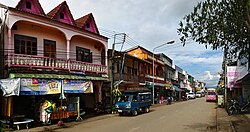 Town centre
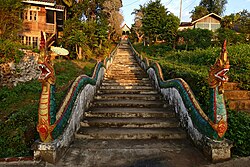 Stairs to the hill of the temple
 Vat Chom Khao Manilat
 Border crossing to Thailand


Climate
edit| Climate data for Houayxay (1990–2019) | |||||||||||||
|---|---|---|---|---|---|---|---|---|---|---|---|---|---|
| Month | Jan | Feb | Mar | Apr | May | Jun | Jul | Aug | Sep | Oct | Nov | Dec | Year |
| Mean daily maximum °C (°F) | 28.3 (82.9) |
31.0 (87.8) |
33.5 (92.3) |
34.2 (93.6) |
32.6 (90.7) |
31.8 (89.2) |
30.5 (86.9) |
30.5 (86.9) |
31.1 (88.0) |
30.8 (87.4) |
29.3 (84.7) |
27.3 (81.1) |
30.9 (87.6) |
| Mean daily minimum °C (°F) | 14.6 (58.3) |
15.6 (60.1) |
18.3 (64.9) |
21.2 (70.2) |
22.7 (72.9) |
23.6 (74.5) |
23.4 (74.1) |
23.2 (73.8) |
22.7 (72.9) |
21.1 (70.0) |
18.1 (64.6) |
15.5 (59.9) |
20.0 (68.0) |
| Average precipitation mm (inches) | 23 (0.9) |
19 (0.7) |
43 (1.7) |
112 (4.4) |
226 (8.9) |
207 (8.1) |
395 (15.6) |
412 (16.2) |
249 (9.8) |
109 (4.3) |
50 (2.0) |
23 (0.9) |
1,868 (73.5) |
| Source: Food and Agriculture Organization of the United Nations[5] | |||||||||||||
References
edit- ↑ "Results of Population and Housing Census 2015" (PDF). Lao Statistics Bureau. Retrieved 19 February 2024.
- ↑ "Slow Boat To Luang Prabang, Laos: How To Survive! 2023". www.backpackerswanderlust.com. 2 November 2023. Retrieved 1 December 2023.
- ↑ "Home". Gibbon Experience. Retrieved 1 December 2023.
- ↑ "Treehouses on top of the world: Zip-lining to lodgings in Laos". Washington Post. 12 April 2023. ISSN 0190-8286. Retrieved 1 December 2023.
- ↑ "Climatology and agroclimatology atlas of the Lao People's Democratic Republic" (PDF). Food and Agriculture Organization of the United Nations. Archived from the original (PDF) on 17 March 2024. Retrieved 17 March 2024.