Size of this preview: 500 × 483 pixels. Other resolution: 248 × 240 pixels.
Original file (500 × 483 pixels, file size: 165 KB, MIME type: image/png)
This is a file from the Wikimedia Commons. Information from its description page there is shown below.
Commons is a freely licensed media file repository. You can help.
Commons is a freely licensed media file repository. You can help.
Summary
| Description |
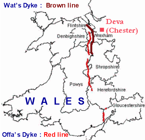
English: I have done a map of Wales with my software and added data about Wat's Dyke and Offa's Dyke.
Wat's Dyke Offa's Dyke |
| Date | |
| Source | Own work |
| Author | Paul0559 |
Licensing
| I, the copyright holder of this work, release this work into the public domain. This applies worldwide. In some countries this may not be legally possible; if so: I grant anyone the right to use this work for any purpose, without any conditions, unless such conditions are required by law. |
File history
Click on a date/time to view the file as it appeared at that time.
| Date/Time | Thumbnail | Dimensions | User | Comment | |
|---|---|---|---|---|---|
| current | 02:57, 8 July 2009 | | 500 × 483 (165 KB) | Paul0559 | Category:History of Galles Category:History of England |
| 03:40, 7 July 2009 |  | 500 × 483 (147 KB) | Paul0559 | {{Information |Description={{en|1=I have done a map of Wales with my software and added data about Wat's Dyke and Offa's Dyke.}} |Source=Own work |Author=Paul0559 |Date=June 2009 |Permission= |other_versions= }} <!--{{ImageUpload|full}} |
File usage
The following 2 pages use this file:
Global file usage
The following other wikis use this file:
- Usage on da.wikipedia.org
- Usage on de.wikipedia.org
- Usage on es.wikipedia.org
- Usage on eu.wikipedia.org
- Usage on fy.wikipedia.org
- Usage on hr.wikipedia.org
- Usage on it.wikipedia.org
- Usage on no.wikipedia.org
- Usage on ru.wikipedia.org
- Usage on simple.wikipedia.org
- Usage on uk.wikipedia.org