


Size of this preview: 500 × 445 pixels. Other resolution: 330 × 294 pixels.

Original file (420 × 374 pixels, file size: 25 KB, MIME type: image/jpeg)

This is a file from the Wikimedia Commons. Information from its description page there is shown below.
Commons is a freely licensed media file repository. You can help.

Commons is a freely licensed media file repository. You can help.
Summary
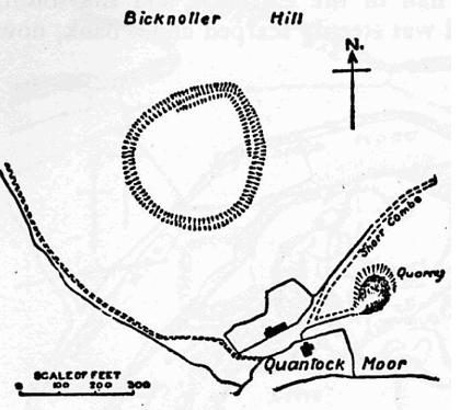
| Description | Map of earthworks at Trendle Ring, Bicknoller, Somerset, England. |
| Date | |
| Source | The Victoria History of the Counties of England, A History Of Somerset, Volume 2. |
| Author | Editor - W.Page; Chapter on Ancient Earthworks - C.H.Bothamley |
| Permission (Reusing this file) |
Copyright has expired in the United Kingdom, and is believed to be in the public domain. |
Licensing

|
This work is in the public domain in its country of origin and other countries and areas where the copyright term is the author's life plus 70 years or fewer.  You must also include a United States public domain tag to indicate why this work is in the public domain in the United States. You must also include a United States public domain tag to indicate why this work is in the public domain in the United States.
|
| This file has been identified as being free of known restrictions under copyright law, including all related and neighboring rights. | |
File history
Click on a date/time to view the file as it appeared at that time.
| Date/Time | Thumbnail | Dimensions | User | Comment | |
|---|---|---|---|---|---|
| current | 21:51, 21 December 2006 | | 420 × 374 (25 KB) | Mikhailfranco~commonswiki | {{Information |Description=Map of earthworks at Trendle Ring, Bicknoller, Somerset, England. |Source=The Victoria History of the Counties of England, A History Of Somerset, Volume 2. |Date=1911 |Author=Editor - W.Page; Chapter on Ancient Earthworks - C.H. |
File usage
The following 4 pages use this file:
Global file usage
The following other wikis use this file:
- Usage on www.wikidata.org
