Size of this preview: 640 × 427 pixels. Other resolution: 320 × 214 pixels.
Original file (640 × 427 pixels, file size: 64 KB, MIME type: image/jpeg)
This is a file from the Wikimedia Commons. Information from its description page there is shown below.
Commons is a freely licensed media file repository. You can help.
Commons is a freely licensed media file repository. You can help.
Summary
| Description |
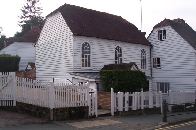
English: The Particular Baptist Chapel, Cranbrook On The Hill near St. David's Bridge. This Strict and Particular Baptist Chapel, has been converted from two cottages and used for worship since 1787. The round headed windows and the simple gravestones in the front are the only indication that this is something other than a humble weather-boarded cottage. |
| Date | |
| Source | From geograph.org.uk |
| Author | David Anstiss |
| Attribution (required by the license) | David Anstiss / The Particular Baptist Chapel, Cranbrook / |
| Camera location | | View this and other nearby images on: OpenStreetMap |
|---|
_heading:270.00&language=en)
| Object location | | View this and other nearby images on: OpenStreetMap |
|---|
_heading:270.00&language=en)
Licensing

|
This image was taken from the Geograph project collection. See this photograph's page on the Geograph website for the photographer's contact details. The copyright on this image is owned by David Anstiss and is licensed for reuse under the Creative Commons Attribution-ShareAlike 2.0 license.
|
This file is licensed under the Creative Commons Attribution-Share Alike 2.0 Generic license.
Attribution:
David Anstiss
- You are free:
- to share – to copy, distribute and transmit the work
- to remix – to adapt the work
- Under the following conditions:
- attribution – You must give appropriate credit, provide a link to the license, and indicate if changes were made. You may do so in any reasonable manner, but not in any way that suggests the licensor endorses you or your use.
- share alike – If you remix, transform, or build upon the material, you must distribute your contributions under the same or compatible license as the original.
|
This is a photo of listed building number 1068779. |
File history
Click on a date/time to view the file as it appeared at that time.
| Date/Time | Thumbnail | Dimensions | User | Comment | |
|---|---|---|---|---|---|
| current | 22:05, 2 March 2011 | | 640 × 427 (64 KB) | GeographBot | == {{int:filedesc}} == {{Information |description={{en|1=The Particular Baptist Chapel, Cranbrook On The Hill near St. David's Bridge. This Strict and Particular Baptist Chapel, has been converted from two cottages and used for worship since 1787. The rou |
File usage
The following 6 pages use this file:
Global file usage
The following other wikis use this file:
- Usage on azb.wikipedia.org
- Usage on de.wikipedia.org
- Usage on nl.wikipedia.org
- Usage on www.wikidata.org