


Size of this preview: 960 × 750 pixels. Other resolution: 330 × 258 pixels.

Original file (521 × 407 pixels, file size: 87 KB, MIME type: image/png)

This is a file from the Wikimedia Commons. Information from its description page there is shown below.
Commons is a freely licensed media file repository. You can help.

Commons is a freely licensed media file repository. You can help.
Summary
| Description |
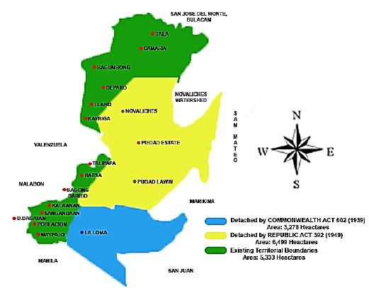
English: Territorial changes of Caloocan |
| Date | |
| Source | http://caloocancity.gov.ph/26-about-us/298-history2 |
| Author | Seventide |
Licensing

|
This work is in the public domain in the Philippines and possibly other jurisdictions because it is a work created by an officer or employee of the Government of the Philippines or any of its subdivisions and instrumentalities, including government-owned and/or controlled corporations, as part of their regularly prescribed official duties; consequently, any work is ineligible for copyright under the terms of Part IV, Chapter I, Section 171.11 and Part IV, Chapter IV, Section 176 of Republic Act No. 8293 and Republic Act No. 10372, as amended, unless otherwise noted. However, in some instances, the use of this work in the Philippines or elsewhere may be regulated by this law or other laws.
|

|
File history
Click on a date/time to view the file as it appeared at that time.
| Date/Time | Thumbnail | Dimensions | User | Comment | |
|---|---|---|---|---|---|
| current | 19:05, 26 April 2020 | | 521 × 407 (87 KB) | Seventide | Cross-wiki upload from en.wikipedia.org |
File usage
The following 3 pages use this file:
Global file usage
The following other wikis use this file:
- Usage on dtp.wikipedia.org
