
Size of this preview: 464 × 553 pixels. Other resolution: 201 × 240 pixels.
Original file (464 × 553 pixels, file size: 217 KB, MIME type: image/png)
This is a file from the Wikimedia Commons. Information from its description page there is shown below.
Commons is a freely licensed media file repository. You can help.
Commons is a freely licensed media file repository. You can help.
| Description |
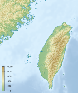
English: Topographic map of Taiwan. Français : Carte topographique de Taiwan.
한국어: 타이완의 지형도. 中文:台灣地形圖 閩南語 / Bân-lâm-gí:Tâi-uân tē-hîng-tôo |
||||||||||
| Date | |||||||||||
| Source | Own work | ||||||||||
| Author | Ksiom | ||||||||||
| Permission (Reusing this file) |
|

File history
Click on a date/time to view the file as it appeared at that time.
| Date/Time | Thumbnail | Dimensions | User | Comment | |
|---|---|---|---|---|---|
| current | 18:17, 23 October 2008 | | 464 × 553 (217 KB) | Ksiom | |
| 13:57, 3 October 2008 |  | 475 × 571 (200 KB) | Ksiom | {{Information |Description={{en|1=Topographic map of Taiwan.}} {{ko|1=타이완의 지형도.}} |Source=Own work by uploader |Author=Ksiom |Date=2008-08-09 |Permission={{GFDL-GMT}} |other_versions= }} Category:Maps of Taiwan [[Category |
File usage
The following 6 pages use this file:
Global file usage
The following other wikis use this file:
- Usage on ca.wikipedia.org
- Usage on cs.wikipedia.org
- Usage on es.wikipedia.org
- Usage on fr.wikipedia.org
- Usage on id.wikipedia.org
- Usage on ja.wikipedia.org
- Usage on ko.wikipedia.org
- Usage on la.wikipedia.org
- Usage on mad.wikipedia.org
- Usage on mn.wikipedia.org
- Usage on mr.wikipedia.org
- Usage on pt.wikipedia.org
- Predefinição:Info/Aeroporto
- Aeroporto Internacional de Taiwan Taoyuan
- Keelung
- Predefinição:Mapa de localização/Taiwan
- Forte Zeelândia (Taiwan)
- Pré-história de Taiwan
- Longtan
- Taiwu
- Aeroporto Internacional de Kaohsiung
- Ilha Verde (Taiwan)
- Ilha das Orquídeas
- Predefinição:Info/Aeroporto/doc
- Cabo Eluanbi
- Língua paiwan
- Predefinição:Mapa de Templos de Taiwan
- Usuário(a):Mariaclaramp/Testes
- Lista de templos de A Igreja de Jesus Cristo dos Santos dos Últimos Dias por localização
- Rio Tamsui
- Rio Zhuoshui
- Usage on ru.wikipedia.org
- Usage on th.wikipedia.org
- Usage on vi.wikipedia.org
- Usage on zh.wikipedia.org