
Size of this PNG preview of this SVG file: 685 × 600 pixels. Other resolutions: 274 × 240 pixels | 548 × 480 pixels | 878 × 768 pixels | 1,170 × 1,024 pixels | 2,340 × 2,048 pixels | 922 × 807 pixels.
Original file (SVG file, nominally 922 × 807 pixels, file size: 189 KB)
This is a file from the Wikimedia Commons. Information from its description page there is shown below.
Commons is a freely licensed media file repository. You can help.
Commons is a freely licensed media file repository. You can help.
Summary
Licensing
This file is licensed under the Creative Commons Attribution-Share Alike 3.0 Unported license.
- You are free:
- to share – to copy, distribute and transmit the work
- to remix – to adapt the work
- Under the following conditions:
- attribution – You must give appropriate credit, provide a link to the license, and indicate if changes were made. You may do so in any reasonable manner, but not in any way that suggests the licensor endorses you or your use.
- share alike – If you remix, transform, or build upon the material, you must distribute your contributions under the same or compatible license as the original.
File history
Click on a date/time to view the file as it appeared at that time.
| Date/Time | Thumbnail | Dimensions | User | Comment | |
|---|---|---|---|---|---|
| current | 14:06, 18 November 2022 | | 922 × 807 (189 KB) | GrandEscogriffe | more correct N/S stretching |
| 01:11, 28 June 2014 |  | 922 × 762 (164 KB) | Spesh531 | adding rivers shown in syria location map3 | |
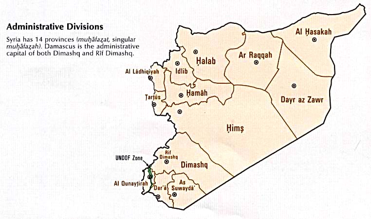
| 17:51, 16 October 2010 |  | 1,000 × 827 (240 KB) | Supreme Deliciousness | {{Information |Description={{en|1=Syria location map following the worldview per mainstream maps: # http://www.lib.utexas.edu/maps/middle_east_and_asia/syria_pol_2007.jpg # http://www.lib.utexas.edu/maps/middle_east_and_asia/syria_pol90.jpg # http://www |
File usage
The following 2 pages use this file:
Global file usage
The following other wikis use this file:
- Usage on ar.wikipedia.org
- Usage on bn.wikipedia.org
- Usage on fr.wikipedia.org
- Syrie
- Damas
- Alep
- Lattaquié
- Soufanieh
- Palais royal de Mari
- Maaloula
- Hama
- Kafroun
- Maarat al-Nouman
- Barrage de Tabqa
- Barrage d’al-Baath
- Barrage de Tichrine
- Monastère Notre-Dame de Seidnaya
- Monastère Morth Maryam de Tell Wardiyat
- Qatana
- Seidnaya
- Raqqa
- Idlib
- Chastel Blanc
- Safita
- Tartous
- Jablé
- Château de Tortose
- Forteresse d'Arima
- Homs
- Qardaha
- Kassab
- Qinnasrīn
- Qanaouat
- Modèle:Géolocalisation/Syrie
- Arslan Tash
- Banias (ville)
- Qouneitra
- Aéroport international de Damas
- Deraa
- Deir ez-Zor
- Masyaf
- Neirab
- Douma (Syrie)
- Musée national de Damas
- Projet:Cartographie/Géolocalisation/Maintenance/Images des pays
- Aéroport international d'Alep
- Aéroport international de Lattaquié
- Stade international d'Alep
- Stade de Khaled bin Walid
- Stade des Abbassides
View more global usage of this file.