Size of this preview: 800 × 521 pixels. Other resolutions: 320 × 209 pixels | 640 × 417 pixels | 1,024 × 668 pixels | 1,396 × 910 pixels.
Original file (1,396 × 910 pixels, file size: 369 KB, MIME type: image/gif)
This is a file from the Wikimedia Commons. Information from its description page there is shown below.
Commons is a freely licensed media file repository. You can help.
Commons is a freely licensed media file repository. You can help.
Summary
| Description |
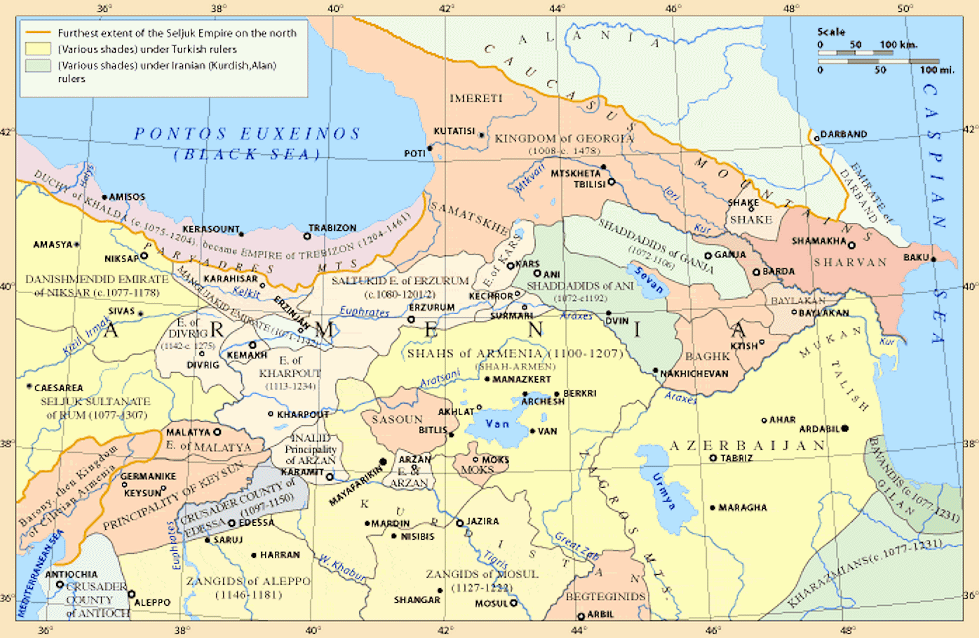
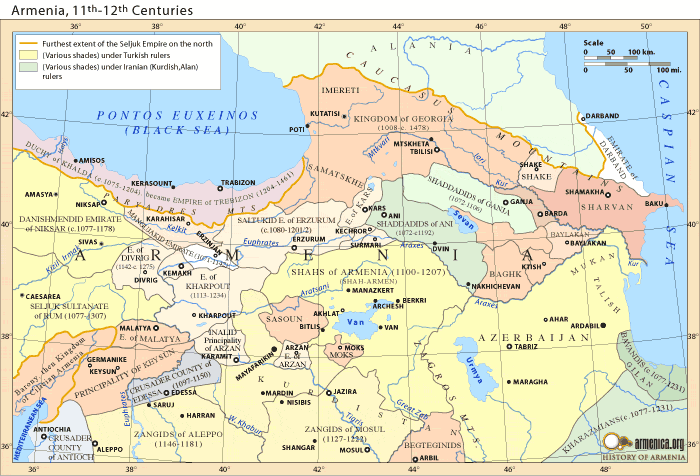
Deutsch: Die Schaddadiden zwischen dem 11. und 12. Jh.
English: Shaddadis, 11th–12th Centuries
Français : L'Shaddadie aux XIe et XIIe siècles, avec notamment les domaines des Cheddadides. L'Arménie aux XIe et XIIe siècles.
עברית: הממלכה הגאורגית (מצפון בכתום) במרחב הממלכות של המאה ה-11-המאה ה-12.
ქართული: შედადიდთა ტერიტორიები XI-XII საუკუნეებში.
Lietuvių: Šadadidų valdos XI-XII a. sandūroje.
Русский: Закавказье в XI-XII вв. |
| Date | Uploaded to Armenica.org before 7 December 2006 (archived version) |
| Source | |
| note | The original source of the Map is Robert H. Hewsen's "Armenia: A Historical Atlas" (2001), page 128 |
| Author | Armenica.org |

|
Attribution information, such as the author's name, e-mail, website, or signature, that was once visible in the image itself has been moved into the image metadata and/or image description page. This makes the image easier to reuse and more language-neutral, and makes the text easier to process and search for. Commons discourages placing visible author information in images.
|
Source
Licensing

|
Permission is granted to copy, distribute and/or modify this document under the terms of the GNU Free Documentation License, Version 1.2 or any later version published by the Free Software Foundation; with no Invariant Sections, no Front-Cover Texts, and no Back-Cover Texts. A copy of the license is included in the section entitled GNU Free Documentation License. |
| This file is licensed under the Creative Commons Attribution-Share Alike 3.0 Unported license. | ||
| ||
| This licensing tag was added to this file as part of the GFDL licensing update. |
This permission only applies to images existing on http://armenica.org/ as of 1 January 2007. Any later images do not fall under this permission!
File history
Click on a date/time to view the file as it appeared at that time.
| Date/Time | Thumbnail | Dimensions | User | Comment | |
|---|---|---|---|---|---|
| current | 09:43, 16 March 2024 | | 1,396 × 910 (369 KB) | Pataliputra! | Size, clarity |
| 16:20, 12 February 2022 |  | 698 × 455 (68 KB) | Abkhazian1 | Reverted to version as of 20:03, 11 April 2020 (UTC) - During the period 1008-1478 coastal lands of north-east black sea from modern Novomikhailovski village was included into the Kingdom of Georgia. There is no sense to arrange borders in this part of black sea coast connecting with Seljuks as Ashok Kerib is doing repeatedly. | |
| 23:07, 13 April 2020 |  | 700 × 476 (64 KB) | Ashok Kerib | Reverted to version as of 00:52, 15 July 2007 (UTC) Seljuks did not control Abkhazia, farther extend of the Seljuk conquest in South Caucasus was Imeretia(Egrisi) | |
| 20:03, 11 April 2020 |  | 698 × 455 (68 KB) | Ercwlff | Reverted to version as of 20:19, 6 April 2020 (UTC) rv suspicious user | |
| 22:11, 8 April 2020 |  | 698 × 455 (64 KB) | Ashok Kerib | Reverted to version as of 21:51, 8 April 2020 (UTC) Seljuks did not control Abkhazia, farther extend of the Seljuk conquest in South Caucasus was Imereta(Egrisi) | |
| 22:05, 8 April 2020 |  | 700 × 476 (64 KB) | Ashok Kerib | Reverted to version as of 00:52, 15 July 2007 (UTC) Seljuks did not control Abkhazia, farther extend of the Seljuk conquest in South Caucasus was Imereta(Egrisi) | |
| 21:51, 8 April 2020 |  | 698 × 455 (64 KB) | Ashok Kerib | Reverted to version as of 11:54, 17 May 2011 (UTC) Seljuks did not control Abkhazia, farther extend of the Seljuk conquest in South Caucasus was Imereta(Egrisi) | |
| 20:19, 6 April 2020 |  | 698 × 455 (68 KB) | Ercwlff | compare with any other source | |
| 11:54, 17 May 2011 |  | 698 × 455 (64 KB) | Quibik | removed the watermark, cropped the top caption and the thin border | |
| 00:52, 15 July 2007 |  | 700 × 476 (64 KB) | Hetoum I~commonswiki | {{Information |Description= |Source= |Date= |Author= |Permission= |other_versions= }} == Summary == {{ConfirmationImageOTRS|source=http://armenica.org/|otrs=2007010210006387}} Category:Armenica images == Licensing == {{GFDL}} |
File usage
The following 16 pages use this file:
- Anatolian beyliks
- Armenian Kingdom of Cilicia
- Emirate
- Emirate of Derbent
- Georgian–Seljuk wars
- Georgian–Shaddadid wars
- Jahan Shah bin Tughril
- Saltukids
- Shaddadids
- Shah-Armens
- Tughril ibn Kılıç Arslan II
- User:Falcaorib/Armenia, Azerbaijan and Georgia
- User:Falcaorib/Medieval Empires (1100-1200 AD)
- User:Falcaorib/Medieval Empires (1300-1500 AD)
- User:Falcaorib/Turkey and Ottoman Empire
- User:Georgiano/sandbox/Georgian Armenia
Global file usage
The following other wikis use this file:
- Usage on ar.wikipedia.org
- Usage on azb.wikipedia.org
- Usage on az.wikipedia.org
- Usage on az.wiktionary.org
- Usage on ba.wikipedia.org
- Usage on ca.wikipedia.org
- Usage on ce.wikipedia.org
- Usage on ckb.wikipedia.org
- Usage on de.wikipedia.org
- Usage on el.wikipedia.org
- Usage on eo.wikipedia.org
- Usage on es.wikipedia.org
- Usage on fa.wikipedia.org
- Usage on fi.wikipedia.org
- Usage on fr.wikipedia.org
- Usage on ha.wikipedia.org
- Usage on he.wikipedia.org
- Usage on hu.wikipedia.org
- Usage on hy.wikipedia.org
- Usage on hyw.wikipedia.org
- Usage on id.wikipedia.org
- Usage on it.wikipedia.org
- Usage on ja.wikipedia.org
- Usage on ka.wikipedia.org
View more global usage of this file.