Size of this preview: 344 × 598 pixels. Other resolutions: 138 × 240 pixels | 276 × 480 pixels | 441 × 768 pixels | 588 × 1,024 pixels | 2,000 × 3,479 pixels.
Original file (2,000 × 3,479 pixels, file size: 2.09 MB, MIME type: image/png)
This is a file from the Wikimedia Commons. Information from its description page there is shown below.
Commons is a freely licensed media file repository. You can help.
Commons is a freely licensed media file repository. You can help.
Summary
| Description |
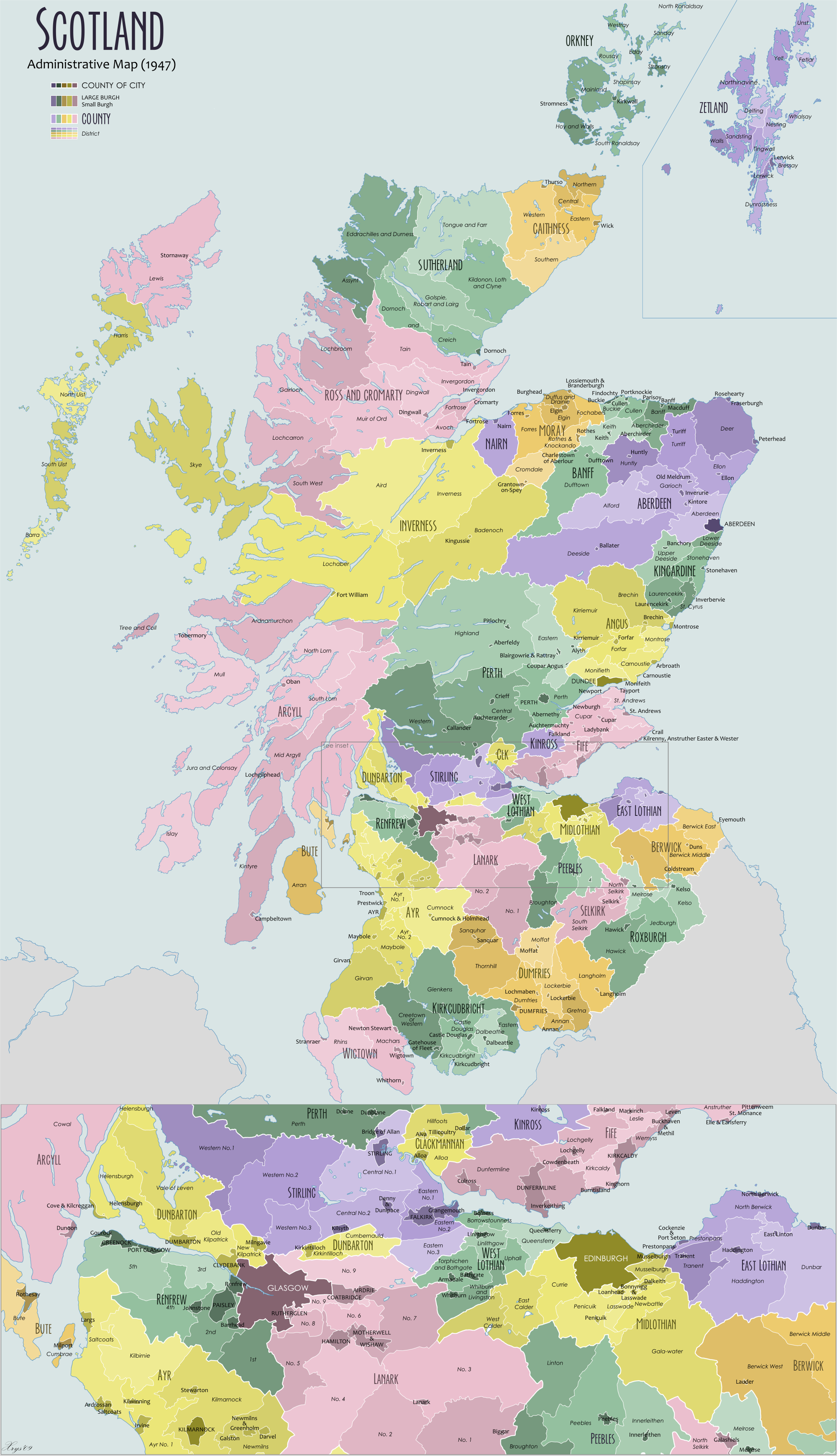
English: Administrative map of Scotland in 1947. Showing counties and districts, counties of cities, large and small Burghs |
| Date | |
| Source | Own work |
| Author | XrysD |
| Other versions |
Derivative works of this file: |

|
This image could be re-created using vector graphics as an SVG file. This has several advantages; see Commons:Media for cleanup for more information. If an SVG form of this image is available, please upload it and afterwards replace this template with
{{vector version available|new image name}}.It is recommended to name the SVG file “Scotland Administrative Map 1947.svg”—then the template Vector version available (or Vva) does not need the new image name parameter. |
Licensing
I, the copyright holder of this work, hereby publish it under the following licenses:

|
Permission is granted to copy, distribute and/or modify this document under the terms of the GNU Free Documentation License, Version 1.2 or any later version published by the Free Software Foundation; with no Invariant Sections, no Front-Cover Texts, and no Back-Cover Texts. A copy of the license is included in the section entitled GNU Free Documentation License. |
| This file is licensed under the Creative Commons Attribution-Share Alike 3.0 Unported license. | ||
| ||
| This licensing tag was added to this file as part of the GFDL licensing update. |
Copyleft: This work of art is free; you can redistribute it and/or modify it according to terms of the Free Art License. You will find a specimen of this license on the Copyleft Attitude site as well as on other sites.
|
You may select the license of your choice.
File history
Click on a date/time to view the file as it appeared at that time.
| Date/Time | Thumbnail | Dimensions | User | Comment | |
|---|---|---|---|---|---|
| current | 10:18, 17 October 2025 | | 2,000 × 3,479 (2.09 MB) | XrysD | Fixed typo: Parisoy-->Portsoy. Updated font for Aberdeen/Dundee |
| 11:08, 16 October 2025 |  | 2,000 × 3,479 (2.09 MB) | XrysD | Fixed typos Monifeith and Turiff. Fixed island near Alloa and Tiree | |
| 11:05, 10 November 2012 |  | 2,001 × 3,480 (2.32 MB) | XrysD | Fixed typo Borrowstouness->Borrowstounness | |
| 12:39, 14 June 2009 |  | 2,000 × 3,479 (2.56 MB) | XrysD | Corrected typo | |
| 12:04, 14 June 2009 |  | 2,000 × 3,479 (2.55 MB) | XrysD | {{Information |Description={{en|1=Administrative map of Scotland in 1947. Showing Counties and Districts, Counties of Cities, Large and Smal Burghs}} |Source=Own work by uploader |Author=XrysD |Date=2009-06-14 |Permission= |other_versions= |
File usage
The following 4 pages use this file:
Global file usage
The following other wikis use this file:
- Usage on de.wikipedia.org
- Usage on es.wikipedia.org
- Usage on it.wikipedia.org
- Usage on nn.wikipedia.org
- Usage on pl.wikipedia.org
- Usage on sl.wikipedia.org
- Usage on tr.wikipedia.org
- Usage on www.wikidata.org
- Usage on zh.wikipedia.org