

Size of this preview: 960 × 960 pixels. Other resolutions: 250 × 250 pixels | 500 × 500 pixels.
Original file (800 × 800 pixels, file size: 256 KB, MIME type: image/jpeg)

This is a file from the Wikimedia Commons. Information from its description page there is shown below.
Commons is a freely licensed media file repository. You can help.
Commons is a freely licensed media file repository. You can help.
Summary
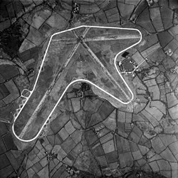
| Description | Vertical aerial view of RAF Brawdy, Pembrokeshire (UK). Although it was used as a satellite airfield by the nearby St David's at this time, Brawdy did not officially open until February 1944 when No. 517 Squadron RAF moved there to fly meteorological sorties over the Atlantic Ocean and the Western approaches. | |||
| Date | ||||
| Source |
|
|||
| Author | Group Captain E.C. Kidd, RAF |

.svg)




| Camera location |  | View this and other nearby images on: OpenStreetMap |  |
|---|

Licensing

|
This work created by the United Kingdom Government is in the public domain.
This is because it is one of the following:
HMSO has declared that the expiry of Crown Copyrights applies worldwide (ref: HMSO Email Reply)
|
 |
File history
Click on a date/time to view the file as it appeared at that time.
| Date/Time | Thumbnail | Dimensions | User | Comment | |
|---|---|---|---|---|---|
| current | 07:18, 12 May 2012 | | 800 × 800 (256 KB) | Cobatfor | == {{int:filedesc}} == {{Information |Description=Vertical aerial view of RAF Brawdy, Pembrokeshire (UK). Although it was used as a satellite airfield by the nearby St David's at this time, Brawdy did not officially open until February 1944 when No. 51... |
File usage
The following page uses this file:
Global file usage
The following other wikis use this file:
- Usage on tg.wikipedia.org
- Usage on www.wikidata.org
