
Size of this preview: 664 × 600 pixels. Other resolutions: 266 × 240 pixels | 531 × 480 pixels | 850 × 768 pixels | 1,134 × 1,024 pixels | 1,633 × 1,475 pixels.
Original file (1,633 × 1,475 pixels, file size: 794 KB, MIME type: image/png)
This is a file from the Wikimedia Commons. Information from its description page there is shown below.
Commons is a freely licensed media file repository. You can help.
Commons is a freely licensed media file repository. You can help.
Summary
| Description |
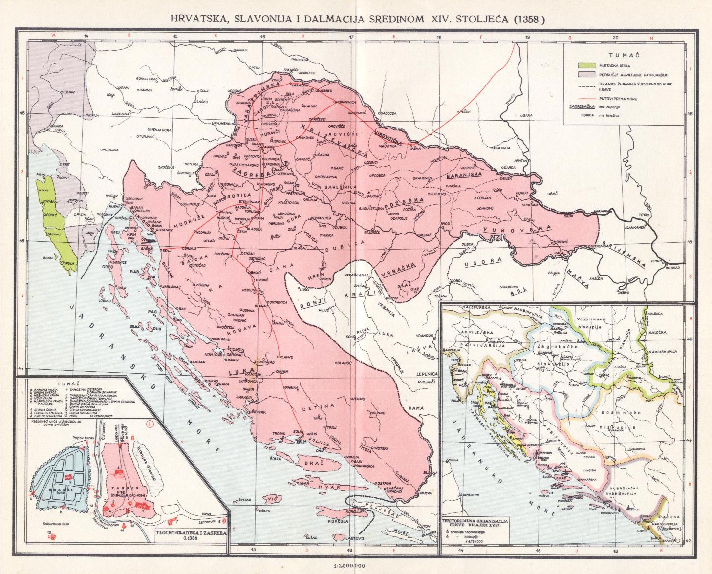
Hrvatski: Karta puteva u Hrvatskoj u kasnom srednjem vijeku, 14. st. (granice za vladavine Šubića).
https://upload.wikimedia.org/wikipedia/hr/1/10/Zadarski_mir.jpg https://tehnika.lzmk.hr/cestovni-promet/ https://kottke.org/19/02/a-detailed-map-of-medieval-trade-routes-in-europe-asia-and-africa https://bs.wikipedia.org/wiki/Putevi_u_srednjovjekovnoj_BosniEnglish: Map of paths in Croatia in the late medieval age, 14th century (borders during the reign of the Šubić's in Croatia)
https://upload.wikimedia.org/wikipedia/hr/1/10/Zadarski_mir.jpg https://tehnika.lzmk.hr/cestovni-promet/ https://kottke.org/19/02/a-detailed-map-of-medieval-trade-routes-in-europe-asia-and-africa https://bs.wikipedia.org/wiki/Putevi_u_srednjovjekovnoj_Bosni |
| Date | |
| Source | Own work |
| Author | Luigimini |
Licensing
I, the copyright holder of this work, hereby publish it under the following license:
This file is licensed under the Creative Commons Attribution-Share Alike 4.0 International license.
- You are free:
- to share – to copy, distribute and transmit the work
- to remix – to adapt the work
- Under the following conditions:
- attribution – You must give appropriate credit, provide a link to the license, and indicate if changes were made. You may do so in any reasonable manner, but not in any way that suggests the licensor endorses you or your use.
- share alike – If you remix, transform, or build upon the material, you must distribute your contributions under the same or compatible license as the original.
File history
Click on a date/time to view the file as it appeared at that time.
| Date/Time | Thumbnail | Dimensions | User | Comment | |
|---|---|---|---|---|---|
| current | 17:13, 4 October 2022 | | 1,633 × 1,475 (794 KB) | Luigimini | Ceste za Duvno i Livno. |
| 10:40, 16 September 2022 |  | 1,633 × 1,475 (787 KB) | Luigimini | Put do Šibenika, putevi u Sloveniji, ispravio Dubrovački put. https://hr.wikipedia.org/wiki/Datoteka:Hrvatsko-Ugarsko_Kraljevstvo.jpg | |
| 13:15, 7 September 2022 |  | 1,633 × 1,475 (765 KB) | Luigimini | Putevi u Slavoniji prema https://www.researchgate.net/figure/Major-settlements-and-trade-routes-in-late-medieval-Hungary_fig1_281490973 | |
| 16:09, 6 September 2022 |  | 1,633 × 1,475 (731 KB) | Luigimini | Uploaded own work with UploadWizard |
File usage
The following 2 pages use this file:
Global file usage
The following other wikis use this file:
- Usage on hr.wikipedia.org
- Usage on www.wikidata.org