Size of this preview: 800 × 333 pixels. Other resolutions: 320 × 133 pixels | 972 × 405 pixels.
Original file (972 × 405 pixels, file size: 514 KB, MIME type: image/png)
This is a file from the Wikimedia Commons. Information from its description page there is shown below.
Commons is a freely licensed media file repository. You can help.
Commons is a freely licensed media file repository. You can help.

|
This map image could be re-created using vector graphics as an SVG file. This has several advantages; see Commons:Media for cleanup for more information. If an SVG form of this image is available, please upload it and afterwards replace this template with
{{vector version available|new image name}}.It is recommended to name the SVG file “Paracel 88.svg”—then the template Vector version available (or Vva) does not need the new image name parameter. |
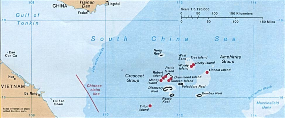
Source: [1] from the Perry-Castañeda Library Map Collection.
| This image is a work of a Central Intelligence Agency employee, taken or made as part of that person's official duties. As a Work of the United States Government, this image or media is in the public domain in the United States.
|

|
File history
Click on a date/time to view the file as it appeared at that time.
| Date/Time | Thumbnail | Dimensions | User | Comment | |
|---|---|---|---|---|---|
| current | 09:16, 23 November 2014 | | 972 × 405 (514 KB) | Pdfpdf | Straighten - rotate anticlockwise by 0.2 degrees. |
| 08:35, 26 May 2007 |  | 976 × 433 (1.21 MB) | Ratzer | Source: [http://www.lib.utexas.edu/maps/] from the [http://www.lib.utexas.edu/maps/ Perry-Castañeda Library Map Collection]. {{PD-USGov-CIA}} |
File usage
The following 3 pages use this file:
Global file usage
The following other wikis use this file:
- Usage on it.wikipedia.org
- Usage on ka.wikipedia.org
- Usage on nl.wikipedia.org
- Usage on pt.wikipedia.org
- Usage on th.wikipedia.org
- Usage on zh.wikipedia.org