Size of this preview: 712 × 338 pixels. Other resolution: 320 × 152 pixels.
Original file (712 × 338 pixels, file size: 109 KB, MIME type: image/png)
This is a file from the Wikimedia Commons. Information from its description page there is shown below.
Commons is a freely licensed media file repository. You can help.
Commons is a freely licensed media file repository. You can help.
Summary
| Description |
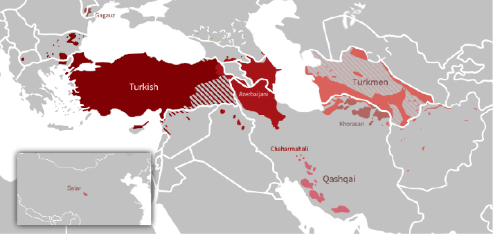
English: Map of the Oghuz branch of the Turkic Languages around the Middle East and Southeast Europe. |
||
| Date | |||
| Source | Own work | ||
| Author | GalaxMaps | ||
| Other versions |
|

Licensing
I, the copyright holder of this work, hereby publish it under the following license:
This file is licensed under the Creative Commons Attribution-Share Alike 4.0 International license.
- You are free:
- to share – to copy, distribute and transmit the work
- to remix – to adapt the work
- Under the following conditions:
- attribution – You must give appropriate credit, provide a link to the license, and indicate if changes were made. You may do so in any reasonable manner, but not in any way that suggests the licensor endorses you or your use.
- share alike – If you remix, transform, or build upon the material, you must distribute your contributions under the same or compatible license as the original.
File history
Click on a date/time to view the file as it appeared at that time.
| Date/Time | Thumbnail | Dimensions | User | Comment | |
|---|---|---|---|---|---|
| current | 09:38, 17 April 2024 | | 712 × 338 (109 KB) | Golden | update Karabakh |
| 09:37, 17 April 2024 |  | 830 × 394 (106 KB) | Golden | Reverted to version as of 18:27, 17 June 2023 (UTC) wrong file | |
| 09:36, 17 April 2024 |  | 1,572 × 881 (476 KB) | Golden | update Karabakh | |
| 18:27, 17 June 2023 |  | 830 × 394 (106 KB) | Golden | Reverted to version as of 16:19, 24 May 2022 (UTC) Got a source for that? Astara in Iran is Azeri-speaking. Areas you added in Azerbaijan (Yardimli and parts of Lankaran) are again Azeri-speaking. Need I remind you that all Talysh in Azerbaijan are bilingual in Azeri too? | |
| 12:02, 17 June 2023 |  | 830 × 394 (133 KB) | AryanTuranica | Removed Talysh areas incorrectly labelled as Azerbaijani. Added missing Turkmen regions in Iran. | |
| 16:19, 24 May 2022 |  | 830 × 394 (106 KB) | GalaxMaps | Redid the map and added labels | |
| 16:48, 22 December 2021 |  | 806 × 393 (102 KB) | Chepny | Reverted to version as of 19:27, 14 December 2021 (UTC) | |
| 17:48, 20 December 2021 |  | 804 × 393 (104 KB) | A poor son of Adam | Reverted to version as of 15:55, 6 December 2021 (UTC) | |
| 19:27, 14 December 2021 |  | 806 × 393 (102 KB) | Chepny | Reverted to version as of 19:25, 14 December 2021 (UTC) | |
| 19:25, 14 December 2021 |  | 804 × 393 (105 KB) | Chepny | Reverted to version as of 19:24, 14 December 2021 (UTC) |
File usage
The following 7 pages use this file:
Global file usage
The following other wikis use this file:
- Usage on ady.wikipedia.org
- Usage on av.wikipedia.org
- Usage on az.wikipedia.org
- Usage on ca.wikipedia.org
- Usage on es.wikipedia.org
- Usage on fa.wikipedia.org
- Usage on fr.wikipedia.org
- Usage on hi.wikipedia.org
- Usage on id.wikipedia.org
- Usage on li.wikipedia.org
- Usage on lv.wikipedia.org
- Usage on mk.wikipedia.org
- Usage on ru.wikipedia.org
- Usage on sr.wikipedia.org
- Usage on th.wikipedia.org
- Usage on tr.wikipedia.org