
Size of this preview: 509 × 599 pixels. Other resolutions: 204 × 240 pixels | 408 × 480 pixels | 652 × 768 pixels | 870 × 1,024 pixels | 1,454 × 1,712 pixels.
Original file (1,454 × 1,712 pixels, file size: 427 KB, MIME type: image/jpeg)
This is a file from the Wikimedia Commons. Information from its description page there is shown below.
Commons is a freely licensed media file repository. You can help.
Commons is a freely licensed media file repository. You can help.

|
This map image could be re-created using vector graphics as an SVG file. This has several advantages; see Commons:Media for cleanup for more information. If an SVG form of this image is available, please upload it and afterwards replace this template with
{{vector version available|new image name}}.It is recommended to name the SVG file “Mauritania rel95.svg”—then the template Vector version available (or Vva) does not need the new image name parameter. |


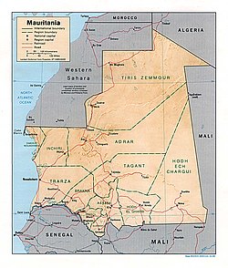
Shaded Relief Map of Mauritania
Source: [1] from the Perry-Castañeda Library Map Collection.
![[1]](http://www.lib.utexas.edu/maps/africa/mauritania_rel95.jpg)
| This image is a work of a Central Intelligence Agency employee, taken or made as part of that person's official duties. As a Work of the United States Government, this image or media is in the public domain in the United States.
|

|
File history
Click on a date/time to view the file as it appeared at that time.
| Date/Time | Thumbnail | Dimensions | User | Comment | |
|---|---|---|---|---|---|
| current | 08:37, 26 April 2007 | | 1,454 × 1,712 (427 KB) | Botev | Shaded Relief Map of Mauritania Source: [http://www.lib.utexas.edu/maps/africa/mauritania_rel95.jpg] from the [http://www.lib.utexas.edu/maps/mauritania.html Perry-Castañeda Library Map Collection]. {{PD-USGov-CIA}} [[Category:Maps |
File usage
The following 4 pages use this file:
Global file usage
The following other wikis use this file:
- Usage on ar.wikipedia.org
- Usage on avk.wikipedia.org
- Usage on eo.wikipedia.org
- Usage on fa.wikipedia.org
- Usage on it.wikipedia.org
- Usage on lfn.wikipedia.org
- Usage on pl.wikipedia.org
- Usage on uk.wikipedia.org
- Usage on ur.wikipedia.org
- Usage on www.wikidata.org
- Usage on zh.wikipedia.org