
Size of this preview: 800 × 509 pixels. Other resolutions: 320 × 204 pixels | 640 × 407 pixels | 1,024 × 651 pixels | 1,280 × 814 pixels | 1,676 × 1,066 pixels.
Original file (1,676 × 1,066 pixels, file size: 3.54 MB, MIME type: image/png)
This is a file from the Wikimedia Commons. Information from its description page there is shown below.
Commons is a freely licensed media file repository. You can help.
Commons is a freely licensed media file repository. You can help.
Summary
| Description |
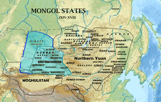
English: Map of the Oirat Confederation |
| Date | |
| Source | |
| Author | Khiruge |

Licensing
This file is licensed under the Creative Commons Attribution-Share Alike 4.0 International license.
- You are free:
- to share – to copy, distribute and transmit the work
- to remix – to adapt the work
- Under the following conditions:
- attribution – You must give appropriate credit, provide a link to the license, and indicate if changes were made. You may do so in any reasonable manner, but not in any way that suggests the licensor endorses you or your use.
- share alike – If you remix, transform, or build upon the material, you must distribute your contributions under the same or compatible license as the original.
File history
Click on a date/time to view the file as it appeared at that time.
| Date/Time | Thumbnail | Dimensions | User | Comment | |
|---|---|---|---|---|---|
| current | 09:39, 23 March 2023 | | 1,676 × 1,066 (3.54 MB) | Pataliputra! | text |
| 09:31, 23 March 2023 |  | 838 × 533 (466 KB) | Pataliputra! | tweak | |
| 09:24, 23 March 2023 |  | 838 × 533 (418 KB) | Pataliputra! | Uploaded a work by Khiruge from {{extracted from|File:Mongolia XVI.png}} with UploadWizard |
File usage
The following 5 pages use this file:
Global file usage
The following other wikis use this file:
- Usage on es.wikipedia.org
- Usage on it.wikipedia.org
- Usage on mn.wikipedia.org
- Usage on pt.wikipedia.org
- Usage on ru.wikipedia.org