
Size of this PNG preview of this SVG file: 340 × 330 pixels. Other resolutions: 247 × 240 pixels | 495 × 480 pixels | 791 × 768 pixels | 1,055 × 1,024 pixels | 2,110 × 2,048 pixels.
Original file (SVG file, nominally 340 × 330 pixels, file size: 84 KB)
This is a file from the Wikimedia Commons. Information from its description page there is shown below.
Commons is a freely licensed media file repository. You can help.
Commons is a freely licensed media file repository. You can help.
Summary
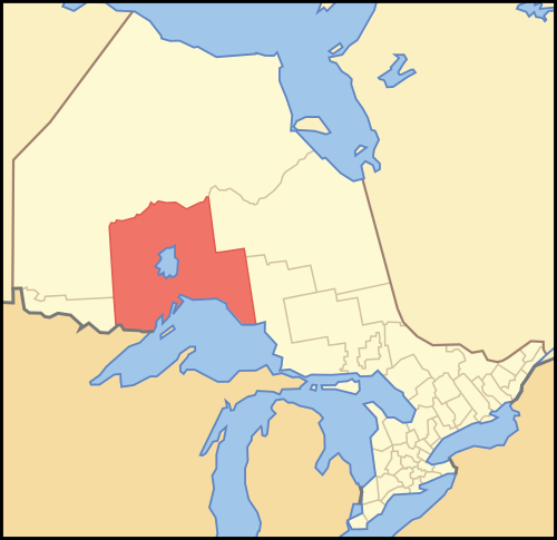
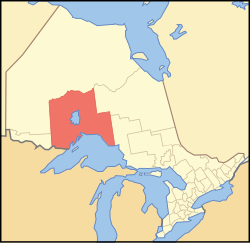
| Description | A map of Ontario highlighting Thunder Bay District |
| Date | |
| Source | Crop and trace of Image:Canada (geolocalisation).svg; trace of Image:Ontario subdivisions.PNG. |
| Author | Vidioman |
| Other versions | en:Image:Ontthb.PNG |
.svg)
Licensing
| I, the copyright holder of this work, release this work into the public domain. This applies worldwide. In some countries this may not be legally possible; if so: I grant anyone the right to use this work for any purpose, without any conditions, unless such conditions are required by law. |
File history
Click on a date/time to view the file as it appeared at that time.
| Date/Time | Thumbnail | Dimensions | User | Comment | |
|---|---|---|---|---|---|
| current | 15:53, 16 October 2007 | | 340 × 330 (84 KB) | Vidioman | {{Created with Inkscape}} {{Information |Description=A map of Ontario highlighting Thunder Bay District |Source=Crop and trace of Image:Canada (geolocalisation).svg; trace of [http://en.wikipedia.org/wiki/Image:O |
.svg)
File usage
More than 100 pages use this file. The following list shows the first 100 pages that use this file only. A full list is available.
- Allan Water (Ontario)
- Ambrose Lake (Thunder Bay District)
- Animbiigoo Zaagi'igan Anishinaabek
- Armstrong, Thunder Bay District, Ontario
- Aroland First Nation
- Beaver River (Thunder Bay District)
- Black Bay Peninsula
- Blackett Creek
- Blackett Lake (Ontario)
- Bluejay Creek (Pic River tributary)
- Bull Lake (Thunder Bay District)
- Canoe Lake (Barnard Creek)
- Canoe Lake (Syine Township)
- Caribou River (Thunder Bay District)
- Centennial Park (Thunder Bay)
- Cleaver Lake (Thunder Bay District)
- Conmee, Ontario
- Corrigan Creek (Ontario)
- De Lesseps Lake
- De Lesseps River
- Demijohn Lake
- Depot Creek (Thunder Bay District)
- Dog River (Ontario)
- Doran River
- East Gorham
- Edward Island (Lake Superior)
- Firesteel River (Ontario)
- Fox River (Thunder Bay District)
- Foxear Creek
- Gibson Lake (Thunder Bay District)
- Gillies, Ontario
- Ginoogaming First Nation
- Gumboot Lake
- Heathcote Lake
- Hewitson River
- Hillcrest Park (Thunder Bay)
- Hornblende Lake
- Hurkett
- Jojo Lake
- Kaministiquia
- Kashabowie
- Kashaweogama Lake
- La Verendrye Provincial Park
- Lac des Mille Lacs 22A1
- Lac des Mille Lacs 22A2
- Lac des Mille Lacs First Nation
- Lake Helen 53A
- Lambert Island
- List of townships in Ontario
- Lomond River (Ontario)
- Longcanoe Lake
- Lyne Lake
- Marchington River
- McKay Lake (Pic River)
- Miniss River
- Mojikit Lake
- Namaygoosisagagun First Nation
- Nicholls Lake
- Nokiiwin Tribal Council
- North Whitesand Lake
- Ojibway Nation of Saugeen
- Onaman Lake
- Osnaburgh 63A
- Partridge Lake (Fox River)
- Pays Plat First Nation
- Pic Mobert North
- Pic Mobert South
- Pick Lake (Thunder Bay District)
- Rainbow Falls Provincial Park
- Red Rock Indian Band
- Roslyn River
- Savant Lake (lake)
- Scum Lake (Ontario)
- Sedgman Lake Provincial Park
- Selassie Lake
- Seseganaga Lake
- Shabaqua
- Shabaqua Corners
- Shebandowan
- Smoothrock Lake
- Snowshoe Lake (Thunder Bay District)
- South Summit Lake (Ontario)
- St. Raphael River
- Sturgeon River (Black Bay Peninsula)
- Sturgeon River (Marchington River tributary)
- Summit Lake (Thunder Bay District)
- Swallow Lake (Matawin River)
- The Third Lake
- Thunder Bay District
- Welcome Islands (Lake Superior)
- Whiddon Lake (Ontario)
- Whiteclay Lake
- Whitefish Lake (Thunder Bay District)
- Whitefish River (Thunder Bay District)
- Whitesand Lake (Hewitson River)
- Whitesand Lake (Lake Nipigon)
- Whitesand River (Lake Nipigon)
- Wiegand River
- Winston Creek (Thunder Bay District)
- Winston Lake (Thunder Bay District)
View more links to this file.
Global file usage
The following other wikis use this file:
- Usage on arz.wikipedia.org
- Usage on de.wikipedia.org
- Usage on fa.wikipedia.org
- Usage on fr.wikipedia.org
- Usage on it.wikipedia.org
- Usage on no.wikipedia.org
- Usage on pl.wikipedia.org
- Usage on pnb.wikipedia.org
- Usage on ru.wikipedia.org
- Usage on sv.wikipedia.org
- Usage on uk.wikipedia.org
- Usage on ur.wikipedia.org
- Usage on www.wikidata.org
- Usage on zh.wikipedia.org