
Size of this PNG preview of this SVG file: 637 × 600 pixels. Other resolutions: 255 × 240 pixels | 510 × 480 pixels | 816 × 768 pixels | 1,088 × 1,024 pixels | 2,176 × 2,048 pixels | 1,107 × 1,042 pixels.
Original file (SVG file, nominally 1,107 × 1,042 pixels, file size: 6.8 MB)
This is a file from the Wikimedia Commons. Information from its description page there is shown below.
Commons is a freely licensed media file repository. You can help.
Commons is a freely licensed media file repository. You can help.
Summary
| Description |
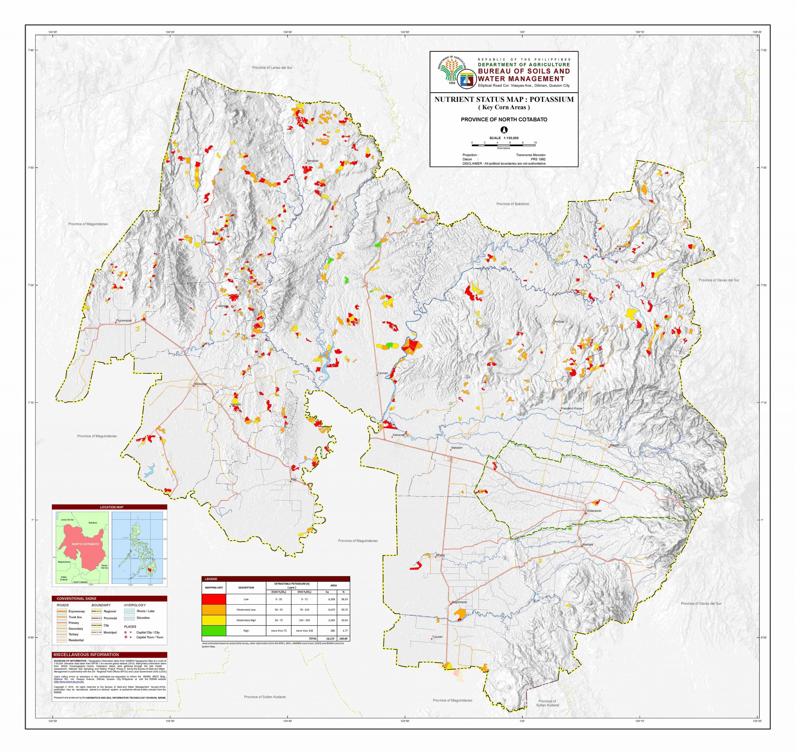
English: Map of the Province of Cotabato and the Bangsamoro Special Geographic Area (SGA) |
| Date | |
| Source |
|
| Author | Own work based on Hellerick's File:Philippines location map (square).svg |
.svg)
Licensing
This file is licensed under the Creative Commons Attribution-Share Alike 3.0 Unported license.
Attribution:
- You are free:
- to share – to copy, distribute and transmit the work
- to remix – to adapt the work
- Under the following conditions:
- attribution – You must give appropriate credit, provide a link to the license, and indicate if changes were made. You may do so in any reasonable manner, but not in any way that suggests the licensor endorses you or your use.
- share alike – If you remix, transform, or build upon the material, you must distribute your contributions under the same or compatible license as the original.
File history
Click on a date/time to view the file as it appeared at that time.
| Date/Time | Thumbnail | Dimensions | User | Comment | |
|---|---|---|---|---|---|
| current | 07:43, 14 April 2024 | | 1,107 × 1,042 (6.8 MB) | Hariboneagle927 | 8 new SGA towns |
| 12:14, 11 March 2023 |  | 1,107 × 1,042 (6.74 MB) | Hariboneagle927 | resized | |
| 12:10, 11 March 2023 |  | 285 × 268 (6.89 MB) | Hariboneagle927 | resize | |
| 12:07, 11 March 2023 |  | 103 × 103 (6.9 MB) | Hariboneagle927 | text | |
| 12:03, 11 March 2023 |  | 103 × 103 (6.85 MB) | Hariboneagle927 | Text | |
| 11:47, 11 March 2023 |  | 103 × 103 (6.84 MB) | Hariboneagle927 | Uploaded a work by {{own work}} based on {{U|Hellerick}}'s File:Philippines location map (square).svg from ;NAMRIA Topographical Map / Bureau of Soils and Water Management *[http://bswm.da.gov.ph/wp-content/uploads/north-cotabato-k-corn-ConvertImage-scaled.jpg North Cotabato Map] with UploadWizard |
.svg)
File usage
The following page uses this file:
Global file usage
The following other wikis use this file:
- Usage on tl.wikipedia.org