
Size of this PNG preview of this SVG file: 800 × 457 pixels. Other resolutions: 320 × 183 pixels | 640 × 366 pixels | 1,024 × 585 pixels | 1,280 × 732 pixels | 2,560 × 1,463 pixels | 1,984 × 1,134 pixels.
Original file (SVG file, nominally 1,984 × 1,134 pixels, file size: 632 KB)
This is a file from the Wikimedia Commons. Information from its description page there is shown below.
Commons is a freely licensed media file repository. You can help.
Commons is a freely licensed media file repository. You can help.
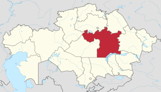
Summary
.svg)
.svg)
.svg)
.svg)
.svg)
.svg)
.svg)

-en.svg)

.svg)
.svg)
.svg)

_(US48).svg)
_(small_islands_magnified)_(-mini_map_-rivers).svg)
.svg)
_(extra_close)_(US48).svg)
.svg)
_(zoom).svg)

.svg)


_(UNMIK).svg)
.svg)
_(disputed_hatched).svg)
_(claimed_and_disputed_hatched).svg)
.svg)
.svg)
_(%2Ball_claims_hatched).svg)

.svg)
_(shade).svg)
_(shade)_(special_marker).svg)
_(-mini_map).svg)
_(-mini_map).svg)
_(-mini_map).svg)


.svg)

.svg)
Licensing
I, the copyright holder of this work, hereby publish it under the following license:
This file is licensed under the Creative Commons Attribution-Share Alike 3.0 Unported license.
- You are free:
- to share – to copy, distribute and transmit the work
- to remix – to adapt the work
- Under the following conditions:
- attribution – You must give appropriate credit, provide a link to the license, and indicate if changes were made. You may do so in any reasonable manner, but not in any way that suggests the licensor endorses you or your use.
- share alike – If you remix, transform, or build upon the material, you must distribute your contributions under the same or compatible license as the original.

|
I'd greatly appreciate, that you attribute this media file to Wikimedia Commons, if used outside Wikipedia or Commons. For use in publications such as books, newspapers, blogs, websites, please insert here the following line:
{{published|author= |date= |url= |title= |org= }}
|
File history
Click on a date/time to view the file as it appeared at that time.
| Date/Time | Thumbnail | Dimensions | User | Comment | |
|---|---|---|---|---|---|
| current | 19:58, 15 May 2025 | | 1,984 × 1,134 (632 KB) | NordNordWest | corr |
| 15:43, 4 October 2022 |  | 1,984 × 1,134 (837 KB) | NordNordWest | upd 2022 | |
| 12:58, 31 July 2011 |  | 1,984 × 1,134 (1.48 MB) | TUBS |
File usage
The following 60 pages use this file:
- 2016 Kazakh legislative election
- Abay District, Karaganda Region
- Akore
- Aksu-Ayuly
- Aktogay, Karaganda Region
- Aktogay District, Karaganda Region
- Baikadam (Karaganda Region)
- Baimyrza (Karaganda Region)
- Baitugan (Karaganda Region)
- Baitugan Rural District
- Balkhash (city)
- Batpakty (Karaganda Region)
- Begazy (village)
- Beldeutas
- Besoba (Karaganda Region)
- Botakara
- Bukhar-Zhyrau District
- Ghabiden Mustafin
- Intaly (Karaganda Region)
- Karagaily
- Karaganda
- Karaganda Region
- Karashoky (Karaganda Region)
- Karkaraly
- Karkaraly District
- Karynshi
- Kertindi
- Koktas (Karaganda Region)
- Koyandy
- Kyzyltu (Karkaraly District)
- List of first-level administrative divisions by area
- Matak, Kazakhstan
- Molodezhny, Karaganda Region
- Nura, Nura District
- Nura District
- Osakarovka
- Oshagandy (Karaganda Region)
- Priozersk, Kazakhstan
- Saran, Kazakhstan
- Sarybel District
- Semizbughy (village)
- Shabanbay Bi
- Shakhtinsk
- Shalkar (village)
- Sherubainura Reservoir
- Shet District
- Shunkyrkudyk
- Tasshoky (Bukhar-Zhyrau District)
- Tegisshildik
- Tegisshildik Rural District
- Temirtau
- Zhamanzhol
- Zhanakurylys (Karaganda Region)
- Zhananegiz
- Zhanatogan
- Zhanazhol (Karaganda Region)
- Zharly (Nurken Rural District)
- Zharly (Tegisshildik Rural District)
- User:Treetoes023/List of the largest country subdivisions by area
- Template:Karaganda Region
Global file usage
The following other wikis use this file:
- Usage on ace.wikipedia.org
- Usage on ar.wikipedia.org
- Usage on azb.wikipedia.org
- Usage on az.wikipedia.org
- Usage on be-tarask.wikipedia.org
- Usage on be.wikipedia.org
- Usage on bg.wikipedia.org
- Usage on ca.wikipedia.org
- Usage on ce.wikipedia.org
- Usage on crh.wikipedia.org
- Usage on cs.wikipedia.org
- Usage on de.wikipedia.org
- Usage on el.wikipedia.org
- Usage on eo.wikipedia.org
- Usage on es.wikipedia.org
- Usage on et.wikipedia.org
- Usage on eu.wikipedia.org
- Usage on fa.wikipedia.org
- Usage on fi.wikipedia.org
- Usage on frr.wikipedia.org
- Usage on fr.wikipedia.org
- Karaganda
- Témirtaou
- Oblys de Karaganda
- Liste des subdivisions par superficie
- Saran (Kazakhstan)
- Chakhtinsk
- Abaï (ville)
- District d'Abay (oblys de Karaganda)
- Balkhach (ville)
- District d'Aktogaï (oblys de Karaganda)
- District de Boukar-Jyraou
- District de Chet
- District de Sarybel
- District de Noura
- District de Karkaraly
- Karsakpay
- Modèle:Palette Oblys de Karaganda
- Botakara
- Priozersk (Kazakhstan)
- Ossakarovka
- Noura (district de Noura)
- Umitker
- Aqadir
- Ortaou
View more global usage of this file.