| Description |
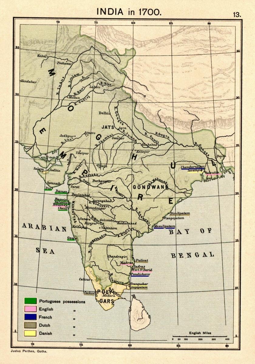
Map of India 1700 showing the Mughal Empire and European trading posts/factory towns from: Joppen, Charles [SJ.] (1907), A Historical Atlas of India for the use of High-Schools, Colleges, and Private Students, London, New York, Bombay, and Calcutta: Longman Green and Co. Pp. 16, 26 maps. Scanned from personal copy, reduced, and highlighted by Fowler&fowler«Talk» 23:38, 24 February 2009 (UTC) |
|---|---|
| Source |
Joppen, Charles [SJ.] (1907), A Historical Atlas of India for the use of High-Schools, Colleges, and Private Students, London, New York, Bombay, and Calcutta: Longman Green and Co. Pp. 16, 26 maps |
| Date |
1907 |
| Author |
Justus Perthes, Gotha./Charles Joppen |
| Permission (Reusing this file) |
See below.
|

This file might not be in the public domain outside the United States and should not be transferred to Wikimedia Commons unless it can be verified to be in the public domain in its country of first publication and that at least 70 years have elapsed since the author died. Commons requires that images be free in the source country and in the United States.
If this file is in the public domain outside the United States, add
|pdsource=yes to this template to hide this warning.If this file is not in the public domain in the source country but will become so in the future, add
|out_of_copyright_in= and then the year its copyright will expire.Please do not transfer to Wikimedia Commons without my permission (for example, if I am on Wikibreak, then please wait for my return) and without making sure that you have the correct uploading information. Fowler&fowler«Talk» 18:43, 8 June 2009 (UTC)
This image or media file is available on the Wikimedia Commons as Image:Joppen1907India1700a.jpg, where categories and captions may be viewed. While the license of this file may be compliant with the Wikimedia Commons, an editor has requested that the local copy be kept too. This file does not meet CSD F8 and should not be tagged as a Commons duplicate. If you desire to nominate it for deletion, notify the tagging editor.
File history
Click on a date/time to view the file as it appeared at that time.
| Date/Time | Thumbnail | Dimensions | User | Comment | |
|---|---|---|---|---|---|
| current | 16:17, 18 April 2010 | | 840 × 1,200 (224 KB) | Beao (talk | contribs) | Removed watermark. |
| 23:38, 24 February 2009 |  | 840 × 1,200 (204 KB) | Fowler&fowler (talk | contribs) | {{Information |Description=Map of India 1700 showing the Mughal Empire and European trading posts/factory towns from: {{Harvard reference|last=Joppen|first=Charles [SJ.]|year=1907|title=A Historical Atlas of India for the use of High-Schools, Colleges, an |
You cannot overwrite this file.
File usage
The following file is a duplicate of this file (more details):
- File:Joppen1907India1700a.jpg from Commons
The following 19 pages use this file:
- Elihu Yale
- Emperor of Hindustan
- Golden Age of India
- History of India
- Indian nationalism
- Mughal Empire
- Muslim conquests in the Indian subcontinent
- Polygar
- Presidencies and provinces of British India
- Two-nation theory
- Uzbeks in Pakistan
- Zabt
- Talk:Mughal Empire/Archive 4
- User:Falcaorib/India and Pakistan
- User:Falcaorib/Modern Empires (1500-1800 AD)
- User:Fowler&fowler
- Wikipedia:Reference desk/Archives/Humanities/2020 December 22
- Wikipedia:VideoWiki/Biryani
- Draft:Historiographic Periodization and Colonial Nomenclature in South Asia