
Size of this preview: 330 × 547 pixels.
Original file (298 × 494 pixels, file size: 27 KB, MIME type: image/png)

This is a file from the Wikimedia Commons. Information from its description page there is shown below.
Commons is a freely licensed media file repository. You can help.
Commons is a freely licensed media file repository. You can help.

|
This map image could be re-created using vector graphics as an SVG file. This has several advantages; see Commons:Media for cleanup for more information. If an SVG form of this image is available, please upload it and afterwards replace this template with
{{vector version available|new image name}}.It is recommended to name the SVG file “Illinois flooding disaster areas, April 2013.svg”—then the template Vector version available (or Vva) does not need the new image name parameter. |
| Description |
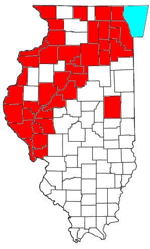
English: Map showing Illinois counties declared disaster areas as a result of flooding in April 2013, as of the morning of 19 April. |
||
| Date | |||
| Source | Map taken from here; information taken from here; map is an Own work | ||
| Author | Nyttend | ||
| Permission (Reusing this file) |
|



File history
Click on a date/time to view the file as it appeared at that time.
| Date/Time | Thumbnail | Dimensions | User | Comment | |
|---|---|---|---|---|---|
| current | 05:52, 21 April 2013 | | 298 × 494 (27 KB) | Nyttend | {{Information |Description={{en|Map showing Illinois counties declared disaster areas as a result of flooding in April 2013, as of the morning of 19 April.}} |Source=Map taken from [http://www2.census.gov/geo/maps/general_ref/cousub_outline/cen2k_pgsz/... |
File usage
The following page uses this file:
