Size of this preview: 960 × 508 pixels. Other resolutions: 330 × 175 pixels | 960 × 508 pixels | 1,280 × 677 pixels.
Original file (1,096 × 580 pixels, file size: 168 KB, MIME type: image/jpeg)
This is a file from the Wikimedia Commons. Information from its description page there is shown below.
Commons is a freely licensed media file repository. You can help.
Commons is a freely licensed media file repository. You can help.
Summary
| Description |
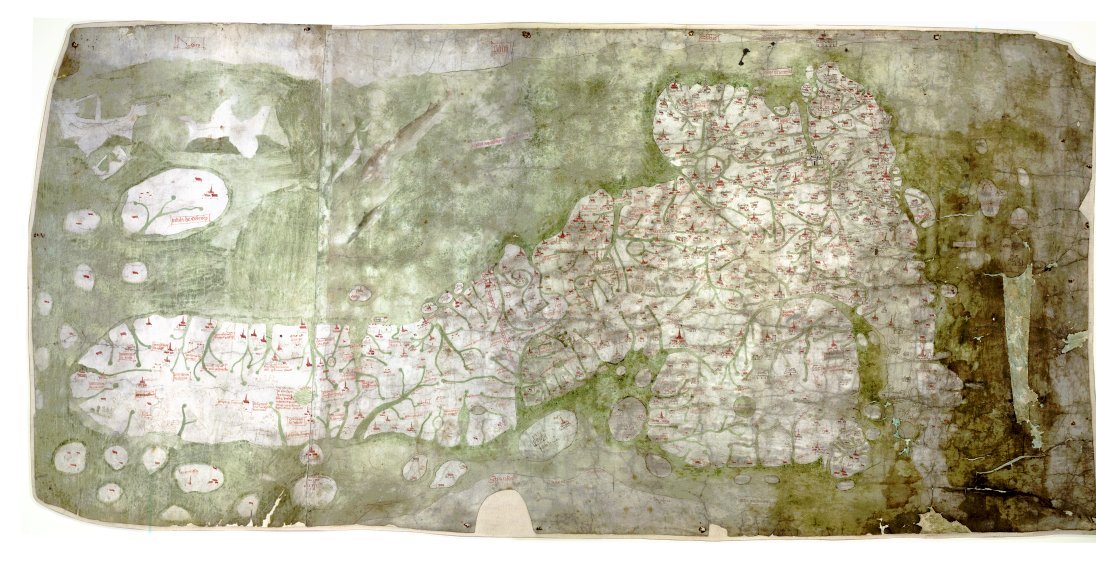
English: The Gough Map or Bodleian Map is a road map of Great Britain, dating from around 1360. The Gough Map is the oldest extant map of the roads of medieval Britain. It is about 115 x 56cm large and was made around 1360. It is named after Richard Gough, who donated the map to the Bodleian Library in 1809. East is on the top. |
| Date | 1370s |
| Source | anonymous, Scan by the Bodleian Library |
| Author | Unknown author |
| Permission (Reusing this file) |
PD-old |
| Other versions | Higher resolution scan at File:Gough_Kaart_(hoge_resolutie).jpg |
.jpg)
| This file comes from the Bodleian Libraries, a group of research libraries in Oxford University. This tag does not indicate the copyright status of the attached work. A normal copyright tag is still required. See Commons:Licensing. |
Links
- The Gough Map archive copy at the Wayback Machine Bodleian Library information page
- Britain's first road map Oxford University Magazine 18,2 (2006)
- Interactive Map archive copy at the Wayback Machine, joint effort of Queen's University Belfast and Bodleian Library
Licensing
|
This is a faithful photographic reproduction of a two-dimensional, public domain work of art. The work of art itself is in the public domain for the following reason:
The official position taken by the Wikimedia Foundation is that "faithful reproductions of two-dimensional public domain works of art are public domain".
This photographic reproduction is therefore also considered to be in the public domain in the United States. In other jurisdictions, re-use of this content may be restricted; see Reuse of PD-Art photographs for details. | ||||
File history
Click on a date/time to view the file as it appeared at that time.
| Date/Time | Thumbnail | Dimensions | User | Comment | |
|---|---|---|---|---|---|
| current | 12:03, 7 May 2007 | | 1,096 × 580 (168 KB) | Mauss | {{Information |Description=The Gough Map or Bodleian Map is a road map of Great Britain, dating from around 1360. |Source= |Date= |Author= |Permission=PD-old |other_versions= }} |
File usage
The following 2 pages use this file:
Global file usage
The following other wikis use this file:
- Usage on hr.wikipedia.org
- Usage on ko.wikipedia.org
- Usage on sh.wikipedia.org
- Usage on sr.wikipedia.org