


Size of this preview: 960 × 533 pixels. Other resolutions: 330 × 183 pixels | 960 × 533 pixels | 1,280 × 711 pixels.


Original file (1,225 × 680 pixels, file size: 451 KB, MIME type: image/png)

This is a file from the Wikimedia Commons. Information from its description page there is shown below.
Commons is a freely licensed media file repository. You can help.

Commons is a freely licensed media file repository. You can help.
Summary
| Description | |
| Date | |
| Source |
Own work Map created using:
some additional sources:
and these symbols: |
| Author | Thoroe |
| Permission (Reusing this file) |
Map data (c) OpenStreetMap (and) contributors, CC-BY-SA |


| Object location |  | View this and other nearby images on: OpenStreetMap |  |
|---|


|
This map has been made or improved in the German Kartenwerkstatt (Map Lab). You can propose maps to improve as well.
|
Licensing


This file is licensed under the Creative Commons Attribution-Share Alike 2.0 Generic license.
Attribution:
Thomas Römer/OpenStreetMap data
- You are free:
- to share – to copy, distribute and transmit the work
- to remix – to adapt the work
- Under the following conditions:
- attribution – You must give appropriate credit, provide a link to the license, and indicate if changes were made. You may do so in any reasonable manner, but not in any way that suggests the licensor endorses you or your use.
- share alike – If you remix, transform, or build upon the material, you must distribute your contributions under the same or compatible license as the original.
File history
Click on a date/time to view the file as it appeared at that time.
| Date/Time | Thumbnail | Dimensions | User | Comment | |
|---|---|---|---|---|---|
| current | 12:41, 16 July 2020 | | 1,225 × 680 (451 KB) | Ras67 | unnecessary black frame cropped |
| 16:28, 4 November 2010 |  | 1,251 × 694 (435 KB) | Thoroe | fix | |
| 13:47, 4 November 2010 |  | 1,251 × 694 (433 KB) | Thoroe | + Planungen Stuttgart21/NBS + Lage S-Bahn-Strecke korrigiert + Stadt-/Gemeindegrenzen | |
| 10:12, 7 August 2010 |  | 1,250 × 694 (253 KB) | Thoroe | Straßenführung korrigiert (Brücke über A8 oben links) | |
| 16:54, 6 August 2010 |  | 1,250 × 694 (253 KB) | Thoroe | Markierungen auf Startbahn | |
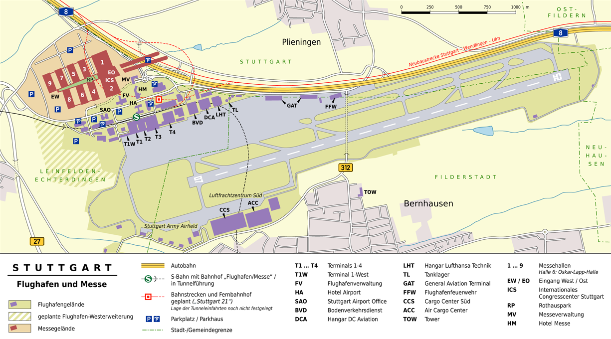
| 14:44, 6 August 2010 |  | 1,250 × 694 (251 KB) | Thoroe | {{Information |Description={{en|1=Map of Stuttgart Airport and adjacent Stuttgart Trade Fair, Germany}} {{de|1=Karte des Stuttgarter Flughafens und der bena |
File usage
The following 4 pages use this file:
Global file usage
The following other wikis use this file:
- Usage on bn.wikipedia.org
- Usage on de.wikipedia.org
- Usage on de.wikivoyage.org
- Usage on en.wikivoyage.org
- Usage on fa.wikipedia.org
- Usage on fr.wikipedia.org
- Usage on hu.wikipedia.org
- Usage on id.wikipedia.org
- Usage on mk.wikipedia.org
- Usage on nl.wikipedia.org
- Usage on pl.wikipedia.org
- Usage on pl.wikivoyage.org
- Usage on th.wikipedia.org
- Usage on uk.wikipedia.org
